Issue Date: Thursday, August 16th, 2018
Issue Time: 1:15 PM MDT
Valid Dates: 8/17 – 8/31
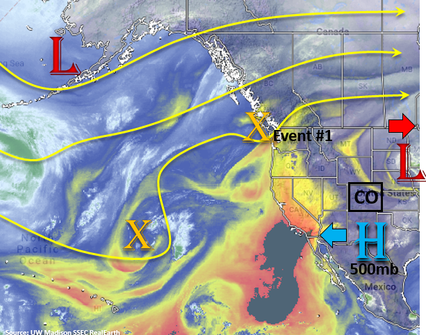
As pointed out in the FTB this morning, the remnants of the last trough are now over the Midwest and the system will continue to push eastward. In its wake, an arid air mass has pushed into northern Colorado. Beginning Friday morning, increased moisture will arrive to this region (east of the Divide) as SE surface winds return with an approaching shortwave. With weak surface winds aloft, there is an Elevated Threat to start this FTO period. Moisture trapped under the ridge over southwest Colorado will again spark another round of afternoon thunderstorms favoring the San Juan and southern Central Mountains on Friday.
On Saturday, the upper-level trough marked in the water vapor imagery below begins to move inland and displace/breakdown the weak ridge. Positive vorticity advection (PVA) on the east side of the trough will provide a large amount of lift for widespread thunderstorms. Early Saturday, showers will begin over the Northwest Slope and increase north to south by early afternoon. By the mid-afternoon hours, the trough will arrive to the eastern mountains where upslope flow and daytime heating are occurring. A line of convergence is expected to produce a strong line of thunderstorms over the adjacent plains by early afternoon with plenty of thunderstorm action over the higher terrains as well. Threats include large hail, damaging winds and heavy rainfall. While moisture over the mountains won’t be quite as deep as over the adjacent plains, rain rates are expected to be high enough to cause flooding concerns near recent burn scars. Steering winds should be quick with the mid-level jet streak, so widespread flooding over the mountains is not a concern at this time. Though these details may change over the next couple of runs. Dew points over the eastern plains could reach 60F, so there are flooding concerns despite swift southeast movement of the storms.
Sunday, activity looks to calm down a bit as the trough drops a cold front over the state. This is expected to draw in some dry air with northerly flow, cap convection and bring much cooler temperatures. While no strong convection is forecast, there is a chance for some stratiform rain associated with the front. To start next week, the ridge begins to build north of Colorado once again. A second trough forms over the Pacific Northwest, but at this time, the models lift the trough north. This should keep northwesterly flow over the state and increase the chances for upper-level disturbances to pass through the state each afternoon through the end of the week. The big question each day will be the availability of low-level moisture. At this time there should be enough residual moisture under the ridge to the west and daily southeasterly flow to the east that mountain convection will be possible each afternoon. There is not enough confidence at this time to forecast anything more than No Apparent Threat.
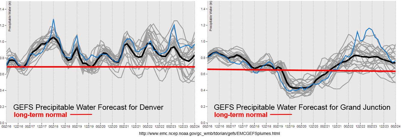
Quite a jump in Precipitable Water (PW) for Denver starting tomorrow as southeasterly surface flow returns. Not much change for western Colorado. With steering flows aloft being light again tomorrow, burn scars will be monitored closely. On Saturday, PW begins to drop off statewide with the exception of the far eastern plains. Western movement of the 500mb high is expected to decrease rainfall chances over western Colorado until next week when the ridge begins to build and the 500mb high shifts east again. Not much confidence in low-level moisture after Tuesday as the GEFS shows a lot of variability both east and west. This likely has to do with how strong the ridge rebuilds and the location of its axis. All details that are nearly impossible to pinpoint this far out. Nonetheless, there should be enough moisture for daily rounds of thunderstorms with the diurnal flow.
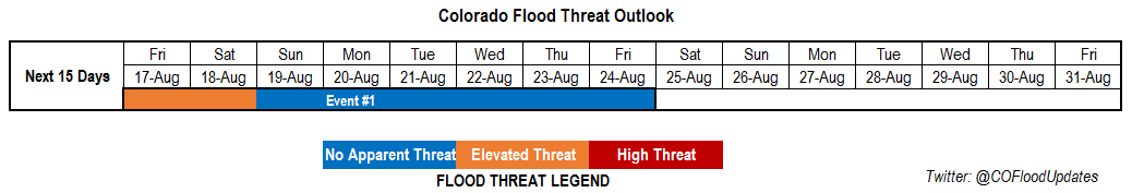
Below we describe the identified precipitation event of this FTO in more detail.
Event #1: Friday (8/17) – Friday (8/24)
Elevated Threat/ No Apparent Threat for severe weather on Saturday and potential heavy rainfall over the eastern plains.
Elevated Threat for Friday as slow steering winds aloft and low-level moisture combine over eastern Colorado. Not much change in PW over the southwest corner of the state, but slow steering winds could cause problems for the 416/Burro burn areas. Saturday looks to have the best potential for flooding as the approach trough brings widespread PVA and strong upper-level winds. While steering flow will increase, large scale lift will promote widespread thunderstorm development. This will be most problematic over the eastern plains where high PW could lead to widespread, heavy rainfall, large hail and damaging winds associated with the line of convection. After Saturday, Sunday should bring a break in heavy rainfall as dry air moves in behind the trough. Some stratiform rain may occur with the passage of the cold front, but this is not expected to cause any flooding issues at this time. Monday to Friday of next week, the ridge begins to build north of Colorado. The strength and location of the ridge is a little hard to determine at this time, but there could be a couple days with a flood threat next week. There should at least be enough moisture for daily rounds of thunderstorms with the diurnal flow. Please check back to Monday’s FTO for more details.