Issue Date: Monday, August 27th, 2018
Issue Time: 12:25 PM MDT
Valid Dates: 8/28 – 9/11
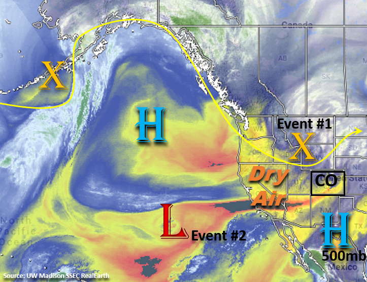
This is expected to be a fairly slow FTO period with dry air being entrained into Colorado due to westerly flow aloft and limiting the heavy rainfall potential. The subtropical high continues to sit over the Pacific with several troughs passing on its north side. These troughs are expected to stay north of the state for this FTO with the exception of the current trough to our north. Today into tomorrow the axis of the trough will affect the northern portion of the state. Today, the main threats will be gusty winds and low relative humidity combining to create critical fire weather. Tonight, the passage of a cold front will increase relative humidity values and reduce high temperatures over the eastern plains for Tuesday. This should in turn reduce the critical fire weather for tomorrow.
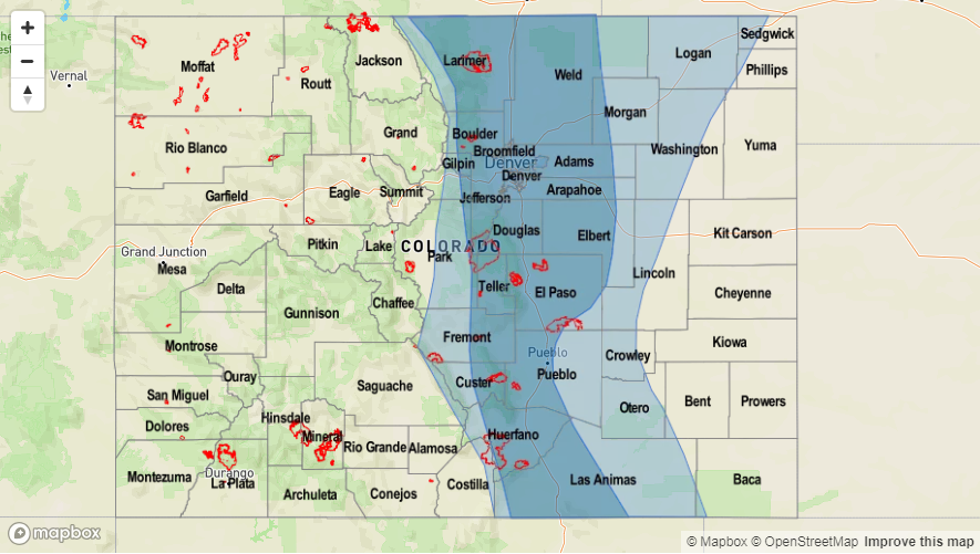
For Tuesday, an upper-level jet oriented from the southwest to northeast will set up over southern Wyoming. With the air mass being near saturation after the passing cold front and northern Colorado being located in the right entrance region of the jet streak, shower and thunderstorm development is expected over the Front Range, Urban Corridor and portions of the Northeast Plains. At the same time, post-frontal upslope flow is expected to increase showers along the Palmer Divide and Southeast Mountains. Storm motion to the southeast will be fairly swift, so widespread flooding is not expected with this band of showers and thunderstorms. Please tune into the FTB tomorrow as increased moisture and slower steering winds may lead to storms producing some localized flooding threats further south.
After Tuesday, westerly flow aloft will return to the state, which will scour out moisture over eastern Colorado and promote downsloping winds. Moisture will also be limited over western Colorado, so the only threat will be a few light showers along and near the Continental Divide each afternoon. The zonal flow aloft will also begin to return warmer temperatures through the end of this week. Early Saturday morning, a weak cold front may drop across the eastern plains. With a weak trough progged to move through the state in the afternoon and upslope flow increasing behind the front, showers and thunderstorms may return to the forecast. While moisture will be limited, this may help trigger a few isolated thunderstorms capable of producing gusty winds. Flow aloft turns more southwesterly on Sunday as a trough moves onto the west coast (Event #2). This flow aloft is expected to increase subtropical moisture across the state, which will cause an uptick in thunderstorm and shower coverage over the holiday weekend. By Monday, flow will become westerly again, so afternoon storm chances will decrease Monday into Tuesday.
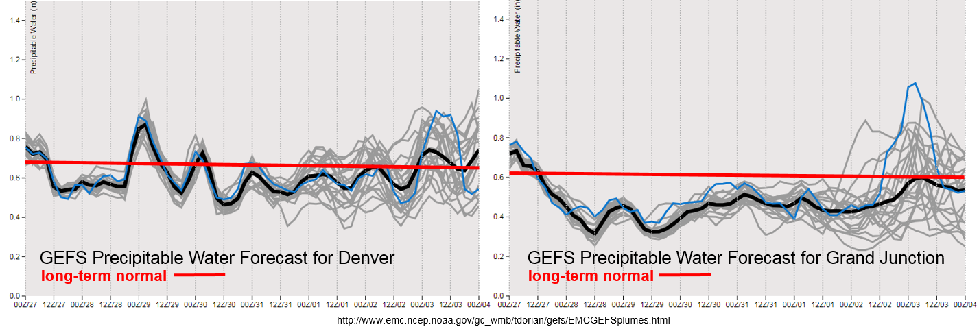
As forecast, exceptionally dry air has worked its way into Colorado with the westerly flow aloft. Precipitable Water (PW) values are expected to drop off and remain below average for western Colorado through the end of the week. Subtropical moisture return for this weekend is still questionable as the GEFS PW plumes show a lot of variation between the members. There is also quite a bit of spread at the end of the week over eastern Colorado though there seems to be a slight upward trend. So, at this time there is No Apparent Threat for Event #2. PW over eastern Colorado does look to increase after the cold front passage later tonight. This may cause some localized heavy rainfall tomorrow though, at this time, widespread flooding is not expected. Scroll down below to find out more about the two identified precipitation event of this FTO.
Event #1: Tuesday (8/28)
No Apparent Threat as post-frontal upslope flow and upper dynamics combine over eastern Colorado for afternoon and evening rainfall.
A strong cold front is forecast to drop over eastern Colorado overnight. This will help return low-level moisture for tomorrow afternoon’s upslope flow regime, so expect showers and thunderstorms to return to the forecast for the eastern mountains and Palmer Ridge. At the same time, a southwest to northeast oriented jet will slowly drop south into northern Colorado. With this area under the right entrance region, upper divergence will promote upward motion. So a band of showers will likely develop in the afternoon and evening oriented in the same manner. Fairly quick motion to the southeast should limit the flooding potential, but some localized flooding may be possible depending on the instability that can build and how much low-level moisture returns. Over the Southeast Mountains and adjacent plains, slower storm motion may be an issue for recent burn scars and urban areas. At this time there is No Apparent Threat, but be sure to tune into the FTB tomorrow as small changes in the details may affect the flood forecast. Over western Colorado, low-level moisture is expected to decrease with the entrainment of drier air. There still may be a chance for some light showers over the Northern Mountains nears the Continental Divide, but flooding is not expected.
Event #2: Saturday (9/1) – Sunday (9/2)
No Apparent Threat as southwesterly flow returns with another trough moving into California.
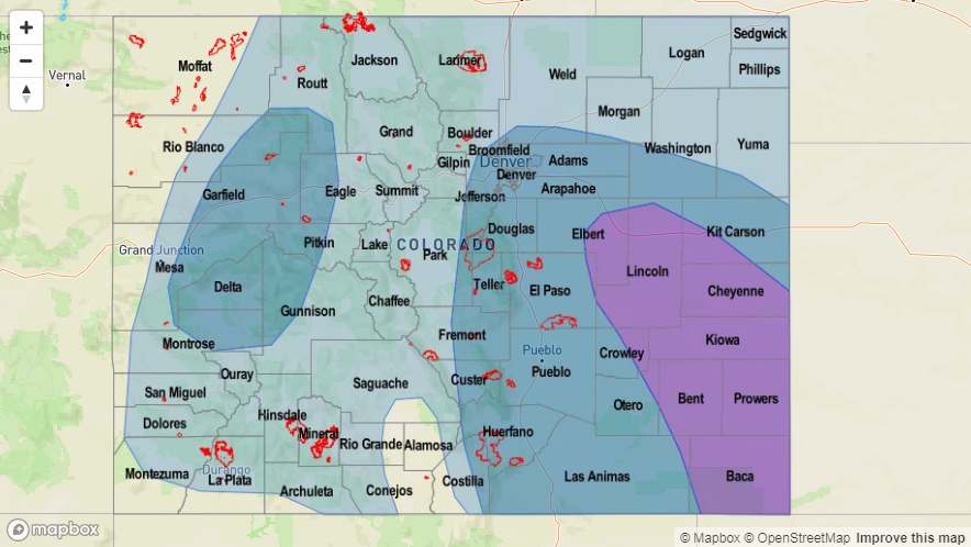
On Saturday morning, models show a weak cold front passing over eastern Colorado. Upslope flow and a shortwave moving through the state on Saturday afternoon may help trigger some more widespread storm development. However, low-level moisture is still expected to be somewhat limited, so the main threat will be gusty winds and dangerous lightning. By Sunday flow aloft turns more southwesterly, which may allow a bit more subtropical moisture to return to the state. Unsure of how much moisture will return, but an uptick in afternoon storm activity statewide is anticipated. At this time there is No Apparent Threat though that may change by the next FTO. The higher low-level moisture values are short-lived as downsloping winds return on Monday and Tuesday. This will push the higher dew points east and cause a downturn in afternoon storm activity.


