Issue Date: Monday, August 20th, 2018
Issue Time: 1:45 PM MDT
Valid Dates: 8/21 – 9/4
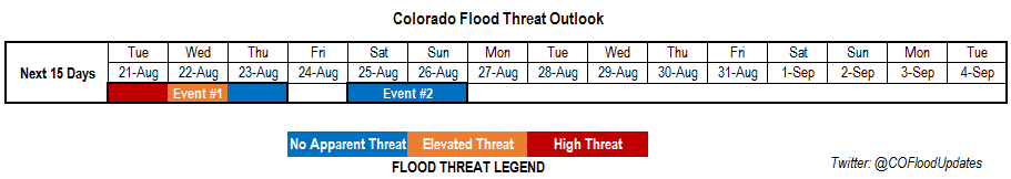
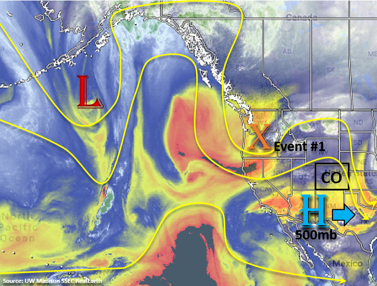
High flood threat along with an Elevated flood threat to start this FTO period as a traditional monsoon pattern sets up and a subtropical moisture plume surges north across the state (Event #1). It has been awhile since we’ve seen this pattern, which will bring some much needed rainfall to northwest corner of the state where a severe drought is in full swing. The upper trough over the Pacific Northwest will slightly push the ridge and center of the 500mb high to the east on Tuesday and allow for an influx of subtropical moisture both east and west of the Continental Divide. The trough will also eject a strong shortwave over the state, which should enhance vertical motion and create more widespread showers and thunderstorms over the higher terrains in the afternoon. High instability and moderate shear will bring a threat for some more severe storms over the far Southeast Plains. Slow steering winds under the ridge will allow storms to produce very heavy rainfall rates in the moisture-rich environment. This will be especially dangerous for recent burn scars over the next couple of days. The high remains over TX through Wednesday evening, which will continue the Elevated flood threat for Wednesday. One reason for the Elevated threat is that heavy rainfall on Tuesday may saturate soils in places and increase runoff on Wednesday. Also, steeper terrains may also have loosened soils, which would mean it would not take much rainfall to trigger additional mud flows and debris slides. However, the Elevated threat for Wednesday is a bit more complicated than it initially seems. Overnight rainfall on Tuesday may make storms more isolated on Wednesday and greatly limit instability over areas. Please tune into the Flood Threat Bulletin on Wednesday morning as the details of the small details for the forecast will become more clear.
By Thursday, the trough moves eastward and brushes the northern border of Colorado. At this time, westerly flow will increase and begin to dry out the air mass, which will cause a downtick in thunderstorm activity. On Friday, westerly flow will increase even more and should dry out the air mass enough to give us a break from rainfall. On Saturday, Event #2 begins as flow aloft turns more southwesterly and pulls high moisture back into the state. The 500mb high builds over eastern TX and southeasterly flow at the surface will return high dew points to eastern Colorado. There is also a chance for subtropical moisture to return over the southwestern corner depending on where the 500mb sets up. Weak flow aloft should return the chance for heavy rainfall, but at this time, there is No Apparent threat. By Monday, the high moves over the southeast US and strong southeasterly flow aloft will pull in a very arid air mass over the state. All in all, the start to next week is expected be cool and dry at this time.
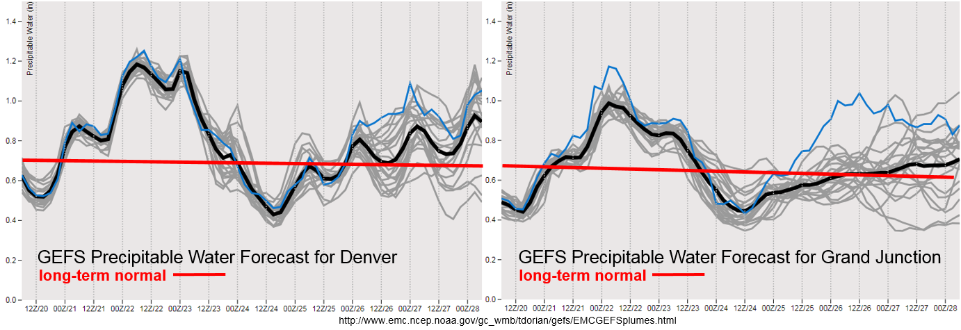
Extremely high PW values working their way north with this next monsoon surge. A strong anomalous surface high will work its way down from the north, which is always a precursor to heavy rainfall over Colorado. PW values over Denver will be about as high as they get for this time of year. The daily max for Denver is about 1.25 inches, and we will be getting very close that record. For Grand Junction we will easily be in the 90th percentile for this time year. With slow steering winds aloft, heavy widespread rainfall is likely tomorrow. The forecast is a little more complicated for Wednesday, but the high moisture sticks around, which will bring an Elevated flood threat. Moisture decreases in the wake of the trough until Saturday and Sunday where the GEFS hints at a return of low-level moisture. Quite a bit of spread for western Colorado, which means some of the members of the ensemble have subtropical moisture returning and others do not. Good consensus that showers and thunderstorms will be on the rise over eastern Colorado, though how much moisture will return is unknown. At this time there is No Apparent threat.
Below we describe the two identified precipitation event of this FTO in more detail.
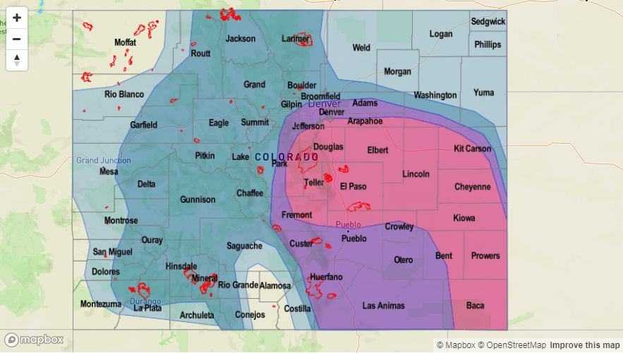
Event #1: Tuesday (8/21) – Thursday (8/23)
High Threat / Elevated Threat / No Apparent Threat as a typical monsoon pattern sets up and a subtropical moisture plume moves north.
High/Elevated Threat for Tuesday – Wednesday of this week. The 500mb subtropical high sets up over Texas, which will pull ample subtropical moisture north into the state. This means there will be a good chance for some wetting rains over the northwest corner of the state, which very much needs the precipitation. However, rain rates may also be high enough to cause some flooding issues. Slow steering winds aloft and a passing shortwave mean widespread, heavy rainfall is likely tomorrow. Over the Southeast Plains, a couple of severe storms are possible with the main threats being strong winds, severe hail and heavy rainfall. Burn scars will be especially vulnerable to flooding over the next couple of days. Threats over the steeper terrains include mud flows, debris slides and local stream flooding. Over the lower elevations, flooding of low-lying streets, field ponding and arroyo flooding are all possible. The flood threat for Tuesday will likely be overnight as upper-level jet will continue to promote upward motion in the high moisture environment. This may make the forecast for Wednesday a bit more complicated, but there should be some breaks in cloud cover that allow instability to build for another round of afternoon thunderstorms. The most likely area for thunderstorm development and heavy rainfall on Wednesday will be over the southern high terrains. Please tune into the FTB tomorrow for a more detailed forecast and more precise location of the heavy rainfall.

Event #2: Saturday (8/18) – Sunday (8/19)
No Apparent Threat as southwesterly flow aloft begins to pull subtropical moisture back into the state.
Event #2 of this FTO still has a lot of details that are in the works, but there will likely be in uptick in thunderstorm activity over eastern Colorado. Flow aloft will turn from westerly to more southwesterly and surface flow over eastern CO will become more southeasterly this weekend. This should begin to pull in higher dew points to eastern Colorado, though how much is still unknown at this time. There is also a chance for subtropical moisture to return to southwest CO. At this time, this would mostly be problematic for the recent burn scars. Nonetheless, expecting increasing showers this weekend after a break from rainfall on Friday. Trends in the subtropical moisture return will be monitored closely with future model runs, and new details will be incorporated into Thursday’s FTO.