FTO 09-10-2018: Drying Trend Begins with Critical Fire Weather likely Wednesday and Thursday

Issue Date: Monday, September 10th, 2018
Issue Time: 1:00 PM MDT
Valid Dates: 9/11 – 9/25

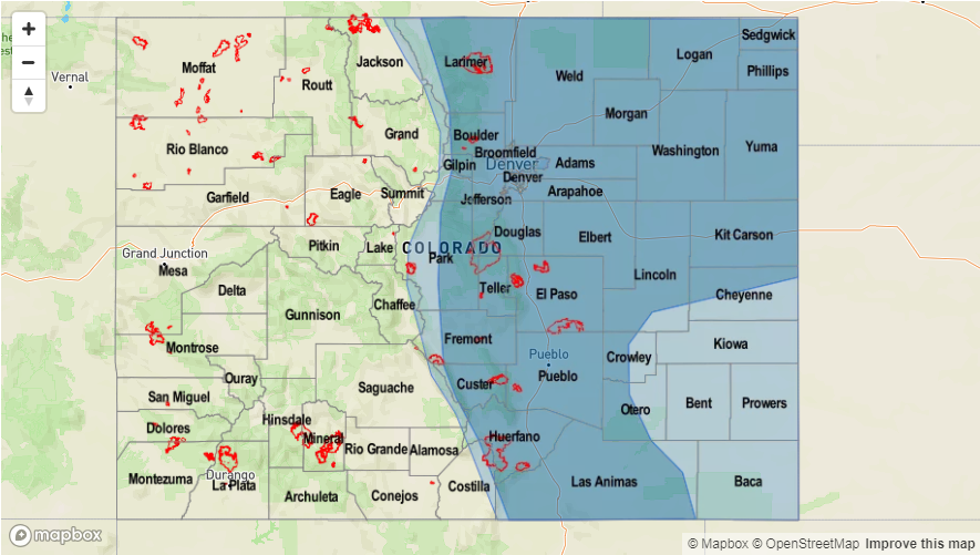
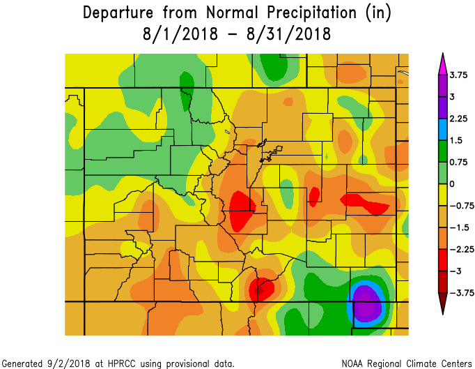
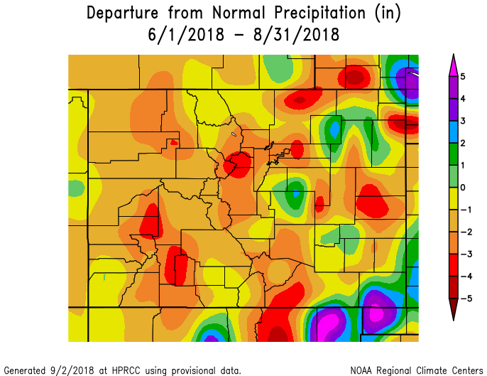
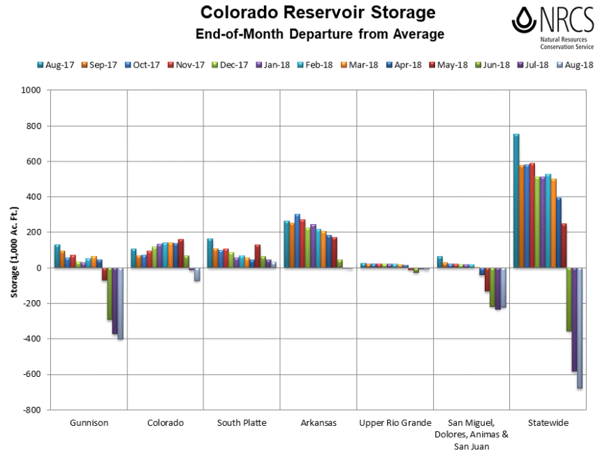
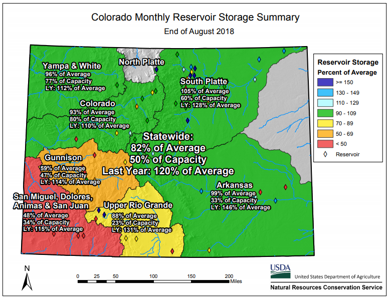
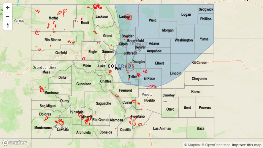
We’ve been monitoring the reservoir storage since the beginning of May since it was such a low snowpack season for the majority of the state. With a weak 2018 monsoon season over western Colorado as well, the southwest corner of the state is currently experiencing exceptional drought conditions with the majority of western Colorado (and the Southeast Mountains) undergoing extreme drought conditions. Below is the end-of-month departure from average (Aug 2017-Aug 2018) as well as a monthly reservoir storage summary for August. Compared to this time last year, statewide reservoir storage is 38% lower. Currently, statewide reservoir storage average is at 82%, which is about 700,000 acre feet below normal. The Blue Mesa Reservoir (Gunnison River Basin) has been in the news lately as it is at 37% of normal capacity. This is the lowest water level seen since 1987. Overall, still seeing below normal storage in the Gunnison and San Miguel/Dolores/Animas/San Juan basins. While there has been slight improvement in the latter basin, it is still about 50% of average. The Colorado and Upper Rio Grande basins are also slightly negative, which is contributing to the statewide deficit. The above average temperatures seen so far in September and warm forecast this week will likely continue to chip away at the storage.

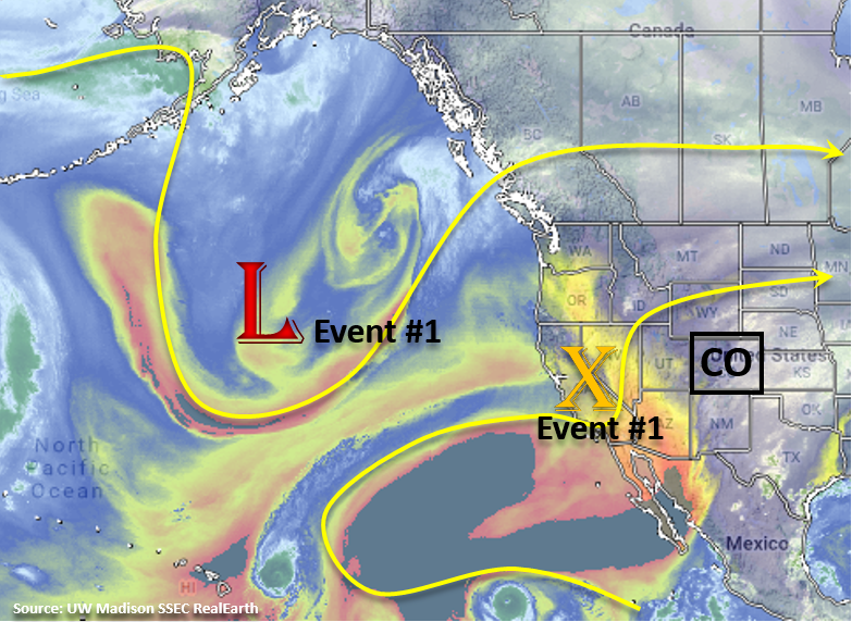
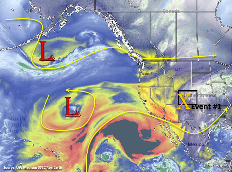
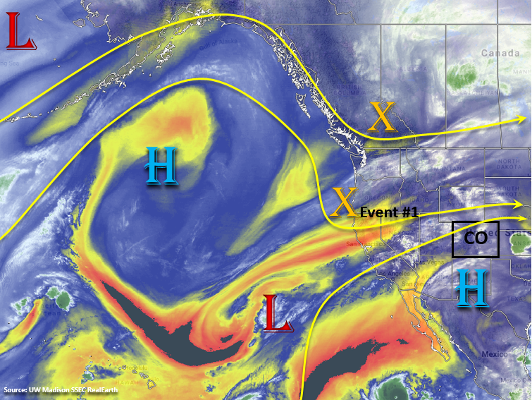
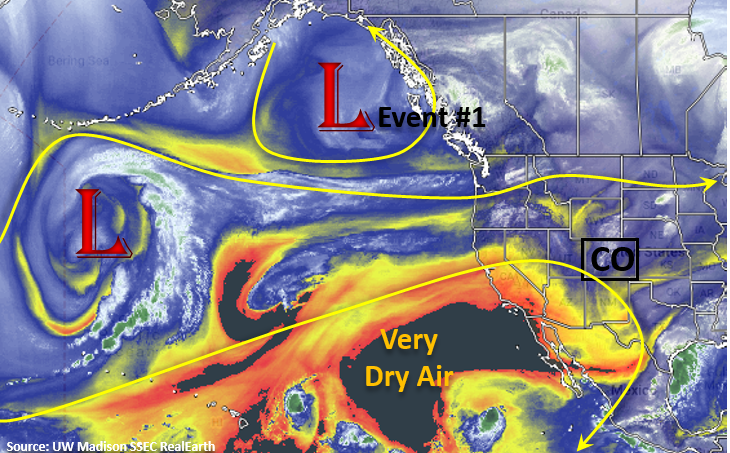
The forecast from Thursday’s FTO is still on track. Westerly upper-level flow begins today and will continue through tomorrow under a weak ridging pattern. This will continue to push the higher moisture to the east, though some residual moisture could produce some patchy showers over the higher terrains on Tuesday (Event #1). A shortwave will move through the state as well, which may help produce widespread, afternoon cloud cover over the high terrains. By Wednesday, upper-level flow will turn southwesterly as a positively tilted trough builds over the west coast. This will continue to entrain a very dry air mass from the southwest (AZ/NM) seen in the water vapor imagery below. So by Wednesday, southwesterly flow should mix out all the residual moisture under the ridge, so not expecting any measureable rainfall. Instead, forecasting plentiful sunshine and warmer temperatures through the start of this weekend.

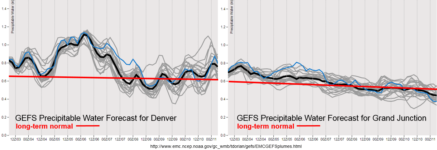
By Wednesday, an upper-level jet oriented southwest to northeast will move into the northwest corner and west-central portion of the state. With warmer temperatures and low relative humidity in place, stronger surface winds will likely produce some critical fire weather over the state focused over this region. Strong winds may also mix down to the surface over the eastern plains during this period, which could cause some fire weather issues here as well. Please tune back into the FTB on Wednesday and Thursday for more details as a Red Flag Warning will likely be necessary. The GFS is still showing the west coast trough moving through the state at the end of next weekend (Event #2), so their will likely be some moisture return with the shortwave and an uptick in afternoon thunderstorm activity. At this time there is No Apparent Threat for flooding during this FTO.

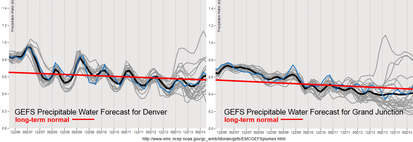
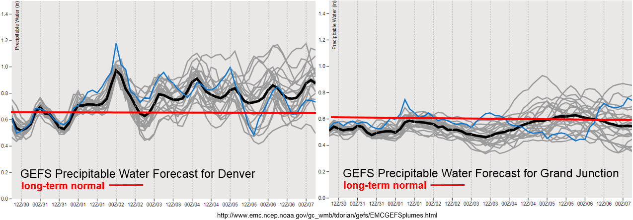
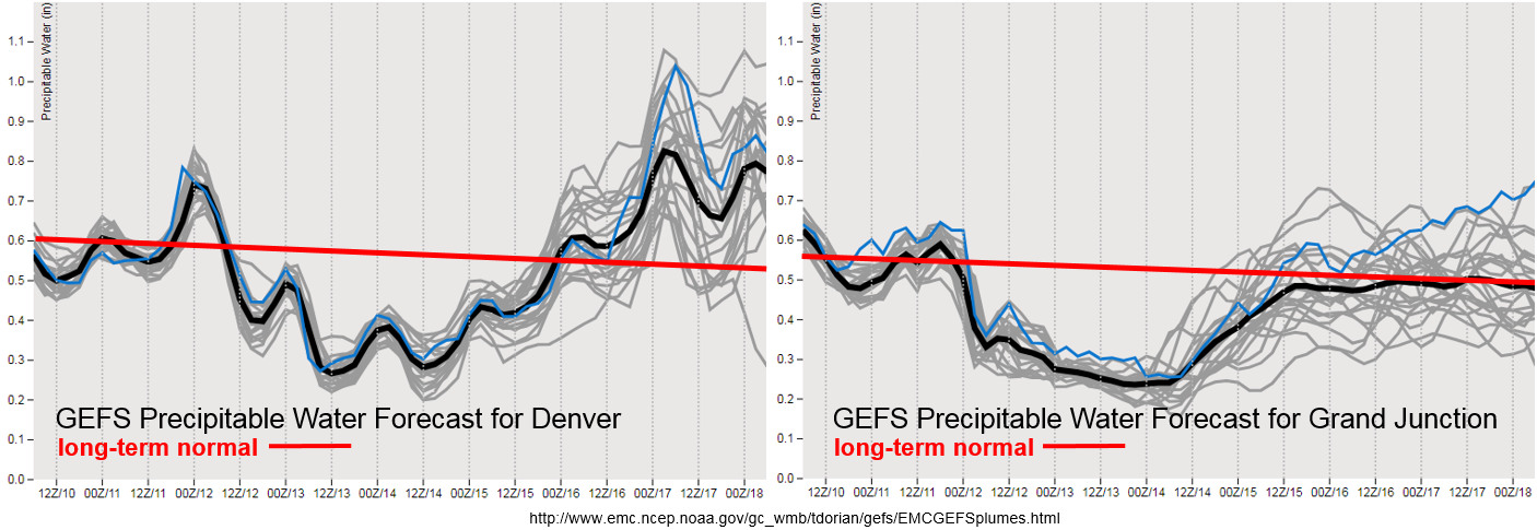
The diurnal low-level moisture cycle shows high enough values on Tuesday for some possible showers and weak thunderstorms over the high terrains. They will likely be focused over the southern Front Range and Southeast Mountains, though a storm or two could form over the San Juan Mountains. Over the adjacent plains, a couple storms may survive and produce some light rainfall over the Palmer Ridge and Northeast Plains. After Wednesday, PW values drop off quite a bit statewide. This should give us a break from rainfall until the trough moves through at the end of next weekend. While moisture return looks weak over western Colorado this weekend, there is an upward trend in PW values over eastern Colorado. While it will likely not reach 1 inch (and cause flooding issues), above average seasonal PW values will likely cause an uptick in storm activity over the higher terrains. Steering winds are forecast to be quick enough that burn scar flash flooding should be avoided (at this time). Please tune back into Thursday’s FTO as models will likely come into better agreement with timing of the trough passage and magnitude/timing of the moisture return.

Below we describe the two identified precipitation event of this FTO in more detail.

Event #1: Tuesday (9/10)

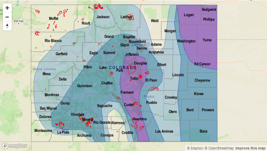
No Apparent Threat as residual moisture under the ridge produces one more day of isolated showers and weak thunderstorms over the mountains and Northeast Plains.

Storm activity should be similar or less than this afternoon as dry air continues to be entrained over the state. None the less, some isolated showers are possible over the higher terrains with residual moisture under the ridge. The passage of an afternoon shortwave will also help to increase cloud cover over the mountains and adjacent plains tomorrow afternoon. Max 1-hour rain rates should stay below flood threat criteria for recent burn areas with higher rainfall totals north of the burn scars. With temperatures near 90F at the lower elevations and low dew point values, rainfall over the I-25 corridor is not likely. If the storms are able to stay together as they move into the Northeast Plains and eastern Palmer Ridge regions (help from the shortwave), dew points in the high 40Fs may help produce some light rain.

Legend

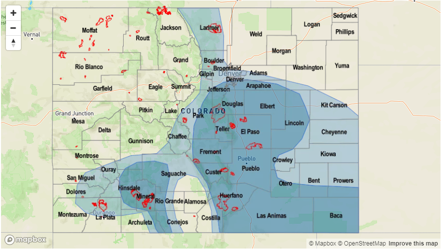
Event #2: Sunday (9/16) – Tuesday (9/18)

No Apparent Threat as a second trough moves eastward from a nearly stationary position this week and brings a boost to low-level moisture.

A little better confidence that a couple shortwaves will move through northern Colorado during this period. A boost to low-level moisture will also be likely though values should stay under 1 inch. Not much low-level moisture return for western Colorado, so there is a better chance for rainfall over the Front Range, Southeast Mountains, Palmer Ridge and Northeast Plains. Still quite a bit of uncertainty as to how much moisture will return for storm coverage and intensity, so at this time we’ll just say there should be an uptick in afternoon shower and thunderstorm activity. Please tune back to Thursday’s FTO for more information and changes to this forecast.


Legend

FTO 09-06-2018: Scattered Storms for this Weekend then a Break in Rainfall Activity

Issue Date: Thursday, September 6th, 2018
Issue Time: 1:15 PM MDT
Valid Dates: 9/7 – 9/21

Before starting the FTO, we’re going to take a quick look at August precipitation and temperature compared to normal across the state. The image below shows the Northwest Slope and Southeast Plains receiving quite a bit of rainfall. The more than average Northwest Slope rainfall was likely due to multiple systems clipping the northern border, while the above average precipitation over Baca and Las Animas was due to a couple systems that dropped heavy rainfall. Temperatures for August (not shown) were below average over eastern Colorado, which makes a lot of sense due to the active weather pattern and lots of mornings with a stratus deck. Western Colorado was above average with the Grand Valley, Southwest Slope and western Central Mountains 3-4F above normal.

The second image below shows the departure from normal precipitation from June 1st – August 31st, which covers the main portion of the monsoon season. Despite above average precipitation over the Northwest Slope in August, overall precipitation is 1 to 3 inches below normal for the season. That’s likely due to not too many monsoon moisture surges making it that far north. Generally, and discussed before, it was a slow monsoon season for western Colorado. There were only a couple classic monsoon setups, which is why precipitation is about 3 to 4 inches below normal in these areas. Over eastern Colorado, Gulf of Mexico moisture was present more from June through August (comparatively), thus there are some pockets of above normal precipitation for the season. Overall, the Southeast Mountains and Front Range (along with all mountain areas) were quite dry, which helped support an active fire season.

The broad upper-level trough mentioned in Monday’s FTO continues to influence the weather over Colorado and is marked in the water vapor imagery below. The extremely dry air has started to make its way into AZ and Mexico, which will come into play next week. Overall, still experiencing some weak steering winds, which paired with high low-level moisture of the state has caused a couple of days of heavy rainfall. For Friday into Saturday (Event #1), the upper-level trough begins to move east and the Colorado light northwesterly flow aloft becomes much stronger. This, paired with a bit more dry air, will keep flood chances low this weekend. On Saturday into Sunday, some residual moisture under the ridge will likely spark some overnight showers associated with the passing trough in the mountains and then another round of afternoon thunderstorms over the higher terrains.

Westerly flow takes over on Monday as a weak ridge/zonal pattern begins to build over the state. Expecting some cooler temperatures to start the work week as cold front passes through the state behind the trough. Downsloping winds aloft will promote drying through the start of next week and start to push the higher moisture east. Mid-week, upper-level flow will turn southwesterly as a positively tilted trough builds over the west coast and Pacific Northwest. This will continue to entrain a dry air mass from the southwest (AZ/NM), so next week should be fairly quiet as far as rainfall. Fire danger will likely increase with higher temperatures and low relative humidity as well. Some stronger surfaces winds over the northwest corner of the state on Wednesday and Thursday could cause critical fire weather. Please tune back into the FTO on Monday for more details. The GFS is still showing the west coast trough moving through the state next weekend (Event #2), but at this time there is low confidence in this solution as well as with availability of low-level moisture for heavy rainfall.

Low-level moisture drops off quite a bit over eastern Colorado on Friday, with less of a decrease over western Colorado. With this, we should see a downtick in storm activity over the higher terrains with little to no flood threat. With slow steering winds, burn scar flash flooding is still a concern over the southern high terrains, so please tune into the FTB tomorrow for a more in-depth analysis. Slight increase in moisture for Saturday night both east and west of the Continental Divide associated with the passing trough. This should cause an uptick in storm activity and may provide some light overnight precipitation in the mountains. Then, the drying trend begins through next week. Denver returns to more seasonal PW values with Grand Junction dropping to below average later in the week. Thus, after Saturday, there is little to no threat for flooding.

Event #1: Friday (9/7) – Sunday (9/9)

No Apparent Threat as the upper-level trough begins to move eastward and brushes the northern border of Colorado.

Storm activity on Friday is expected to decrease as more dry air in entrained into the state. The best chance for afternoon storms will be over the southern high terrains. Flooding is not expected at this time, though recent burn scars may be vulnerable due to slower steering winds. On Saturday, moisture increases some with the passing trough. At this time, not expecting too much instability, but there will likely be an increase in afternoon storms over the northern high terrains with a couple stronger thunderstorms possible. Faster steering winds aloft should help to decrease the flood threat. There is also a potential for rainfall over the eastern plains as the system moves eastward and continues to provide upper-level support for some thunderstorms. Sunday, not expecting much rain, but some residual moisture may trigger a couple isolated storms over the southern high terrains. Storms will likely be confined along and near the Continental Divide. Due to the entrainment of drier air, storms that do form this weekend will have the potential for some gusty outflow winds and also produce dangerous lightning.

Legend
Event #2: Saturday (9/15) – Sunday (9/16)

No Apparent Threat as the second trough moves eastward from a nearly stationary position next week.

Again, little to no confidence in this forecast, but it looks like the next trough will still move eastward sometime next weekend. This will likely increase moisture over the state and could cause an uptick in storm activity after a week of negligible rainfall. Not much confidence in mid- and low-level moisture either, so there is No Apparent Threat at this time. There is still too little confidence in the forecast to produce a precipitation map. Just like last week, please tune back into Monday’s FTO as models will likely come to more agreement or at least start trending toward a similar solution.


FTO 09-03-2018: Slow Steering Winds and High Low-Level Moisture Combine for an Elevated Flood Threat

Issue Date: Monday, September 3rd, 2018
Issue Time: 1:20 PM MDT
Valid Dates: 9/4 – 9/18

Quite an interesting pattern in the water vapor imagery below. Colorado is caught between the flow to the north and south, so weak steering winds aloft are forecast for the first part of this FTO. Currently, an upper-level trough is over the four corners and will continue to influence the weather over the next couple of days with slow movement to the northeast. Extra energy with this upper-level low will help make afternoon showers more widespread and help continue the chances for storms after sundown. Over the next couple of days, upslope flow will continue, which will bring afternoon showers and thunderstorms into the forecast (Event #1). A cold front is expected to move through the area on Tuesday evening, which may help trigger some stronger storms over the eastern plains with increased convergence and should help moisten the low-levels for another round of afternoon storms on Wednesday over the higher terrains. Some snow may even be possible over the highest elevations on Wednesday evening. Also seen in the water vapor imagery is a lot of dry air (yellow, orange and black). This drier air is expected to move into the state starting Friday, which should start to limit the chances for rainfall this weekend into next week. Westerly flow aloft increases starting Monday, so stronger dry air entrainment and downsloping winds should keep measureable rainfall chances low for the start of next week. There are quite a few differences between the GEFS members after mid-next week, so there will only be one FTO event for this forecast.

Should be an active start to the week. While flow aloft is quite weak, it remains from the southeast, which will allow upper-level shortwaves to rotate through the state each day. Low-level moisture will also remain high over the eastern plains with southeasterly surface flow. PW values are expected to be well above average through Thursday as seen in the GEFS PW plumes below. Tuesday afternoon, northerly flow near the Front Range is expected produce a line of convergence over the Northeast Plains where it meets the southeasterly surface flow. This will allow some stronger storms to develop over the eastern plains in a high moisture environment. With slow steering winds aloft, heavy rainfall will be possible. A cold front pushes through the state on Tuesday evening and the GEFS shows PW values to increase over eastern Colorado well above the 90th percentile for this time of year. Thus, an Elevated Flood Threat has been issued for the next two days.

By Thursday, moisture begins to decrease and flow aloft on Friday turns more northwesterly. Throughout the weekend, the flow becomes more northerly, which starts the entrainment of the dry air seen in the water vapor imagery above. A small disturbance may cause some isolated showers on Sunday as it passes through the state, but with low-level moisture on the decrease, minimal rainfall is expected with the high-based storms. Monday through Wednesday of next week, entrainment of the dry air with westerly flow aloft should bring PW values much closer to average for this time of year. Some high-based, isolated storms are possible over the higher terrains though measurable rainfall should remain nominal.

Over western Colorado, moisture steadily decreases over the next week. So outside the slight chance for a Low threat over the 416/Burro burn scars tomorrow, flooding is not expected. Wednesday, some lighter rainfall is possible over the higher terrains though it will become more isolated in nature. Starting Sunday, PW values are forecast to be under 0.5 inches. Models are currently showing the upper jet setting up along the CO/WY border at this time. This may bring back fire danger to the northern portion of the state if the stronger winds mix down to the surface, especially over the Northwest Slope and Northern Mountains. More on this in Thursday’s FTO. Scroll below to read more details about the lone event of this FTO.

Event #1: Tuesday (9/4) – Thursday (9/6)

Elevated/No Apparent Threat as PW values remain near and above the 90th percentile over eastern Colorado the next couple of days.

Weak southwesterly flow aloft will keep an active weather pattern over the state, and it will allow multiple shortwaves to rotate through each day. If timed correctly, these shortwaves may help produce more widespread storm action. Southeasterly surface flow over the eastern plains should keep high low-level moisture in place with weak steering winds aloft through Thursday. On Tuesday, a cold front will drop through the state and convergence along the front will allow some stronger storms to develop over the eastern plains. These storms could produce mildly severe weather and heavy rainfall that may cause flooding issues for local streams and low-lying roads. Post-frontal upslope flow on Wednesday will likely create some heavy rainfall pockets over the Front Range and Southeast Mountains. Threats include mud flows, debris slides and local stream flooding with recent burn scars being extra vulnerable. Although moisture starts to decrease on Thursday, another round of afternoon storms over the higher terrains is possible. The most likely area for storms is over the Southeast Mountains, which will again expose recent burn scars to a potential flood threat. Please check back to the FTB each day this week for a more detailed forecast.

Legend

FTO 08-30-2018: Uptick in Storm Coverage to Start the Holiday Weekend

Issue Date: Thursday, August 30th, 2018
Issue Time: 10:30 AM MDT
Valid Dates: 8/31 – 9/14

The water vapor imagery below shows a continuation of the trough – ridge – trough pattern over the eastern Pacific and western North America similar to Monday. As various troughs rotate around the high and drop into the Great Basin, they will produce an active weather period of 1 to 2 days over Colorado before moving eastward. Also seen in the water vapor imagery is a lot of dry air (yellow and orange). The troughs that have been moving through the area over the last week or so have only been brining minimal increases in moisture. With the 500mb high anchored west of Texas, the entrainment of dry air continues and limits rainfall chances over the state. The elongated trough associated with Event #1 is currently moving eastward into CA. Beginning tomorrow the tough moves into the Great Basin and by Friday afternoon begins to turn flow aloft from westerly to more southwesterly through Saturday. This will force the high eastward and will allow Precipitable Water (PW) to increase over the state from west to east returning the chances for rainfall this weekend. There is divergence between the GEFS members after Saturday, though moisture should stay high enough for showers and thunderstorms to return to the forecast each afternoon over the eastern high terrains through Tuesday.

Therefore, we expect a more active holiday weekend in terms of showers and thunderstorms when compared to this week. Today there will be elevated fire danger across the northwest corner of the state with stronger winds mixing to the surface and low relative humidity values. By Friday, low-level moisture increases over the San Juan Mountains, which means there is a chance for some weak showers and thunderstorms along and near the Continental Divide. PW values are anticipated to stay below 0.75 inches, so there is No Apparent Flood Threat. Looking at the PW values over Grand Junction, at this time, it doesn’t seem that the higher moisture will make it too far north. So although there may be an increase in cloud cover over the Central and Northern Mountains, the possibility for wetting rains is low. However, with increased shortwave activity, an isolated storm or two is possible over the Central Mountains. Moisture is on the rise east of the Divide as well, so some high-based storms are possible during the afternoon.

On Saturday, PW values look to increase quite a bit over eastern Colorado with southeasterly surface winds returning behind the front. However, shallow moisture return and dry air entrainment may be possible looking at the water vapor imagery above and using a persistent forecast. Expecting storms to form over the mountains in the early afternoon hours and move east throughout the afternoon and evening. Storm motion at this time is forecast to be fairly slow, so there may need to be an increase for the flood threat on Saturday. However, details in instability will be important as high clouds are expected behind the front. The lack of knowledge in the details means No Apparent Threat is issued, but please tune back into the FTB on Saturday as an upgrade is possible. The increase in subtropical moisture over the southwest corner of the state is short-lived, so not expecting much (if any) rainfall after Friday.

Into next week, model members really start to diverge from one another. For western Colorado, the chances for afternoon rainfall will be low, though an isolated, weak storm is possible over the higher terrains during the afternoon hours. Moisture should stay high enough that there will be a higher chance for isolated showers and thunderstorms over the eastern high terrains each afternoon. Low-level moisture will be the key ingredient, which will need to assessed each morning. So please tune back into the FTO on Monday as model guidance will likely come into more agreement by then. Scroll below to read more details about the identified precipitation events of this FTO.

Event #1: Friday (8/31) – Tuesday (9/4)

No Apparent Threat as post-frontal upslope flow and upper dynamics combine for showers and thunderstorms over the holiday weekend.

Southwesterly flow aloft will return to the forecast starting tomorrow, which will increase low-level moisture from west to east across the state. Friday, some isolated storms are possible over the eastern San Juan Mountains with high-based storms likely over eastern Colorado. At this time there is No Apparent Threat as storms should be far enough east to not track over the 416/Burro burn scars. Saturday looks to be the most active day of the weekend with surface southeasterly flow returning low-level moisture behind the front. Forecasting storms to return to the eastern high terrains and track eastward throughout the afternoon and evening. Slow steering winds may create problems over the recent burn scars in the Southeast Mountains. Please tune back into the FTB on Saturday for more details. Sunday looks to be a bit quieter, though some isolated storms over the eastern high terrains are possible. Starting next week, models diverge quite a bit from one another. However, moisture looks to remain high enough east of the Divide for isolated afternoon storms over the higher terrains each afternoon.


Legend

Event #2: Friday (9/7) – Sunday (9/9)

No Apparent Threat as another trough digs over the west coast and returns low-level moisture with southwesterly flow.

While there is not much confidence in this forecast, I thought it might be worth mentioning that another trough may move over the west coast into the Great Basin at the end of next week. By Thursday, models show a ridge building over the state. On Friday, the ridge shifts eastward as a trough approaches from the west. This could increase southwest flow and moisture, which would upturn the chances for rainfall once again from Friday through Sunday. There is little to no confidence in the forecast, so no precipitation map has been created. Please tune back into Monday’s FTO as models will likely come to more agreement or at least start trending toward a similar solution.