Issue Date: Thursday, August 30th, 2018
Issue Time: 10:30 AM MDT
Valid Dates: 8/31 – 9/14

The water vapor imagery below shows a continuation of the trough – ridge – trough pattern over the eastern Pacific and western North America similar to Monday. As various troughs rotate around the high and drop into the Great Basin, they will produce an active weather period of 1 to 2 days over Colorado before moving eastward. Also seen in the water vapor imagery is a lot of dry air (yellow and orange). The troughs that have been moving through the area over the last week or so have only been brining minimal increases in moisture. With the 500mb high anchored west of Texas, the entrainment of dry air continues and limits rainfall chances over the state. The elongated trough associated with Event #1 is currently moving eastward into CA. Beginning tomorrow the tough moves into the Great Basin and by Friday afternoon begins to turn flow aloft from westerly to more southwesterly through Saturday. This will force the high eastward and will allow Precipitable Water (PW) to increase over the state from west to east returning the chances for rainfall this weekend. There is divergence between the GEFS members after Saturday, though moisture should stay high enough for showers and thunderstorms to return to the forecast each afternoon over the eastern high terrains through Tuesday.
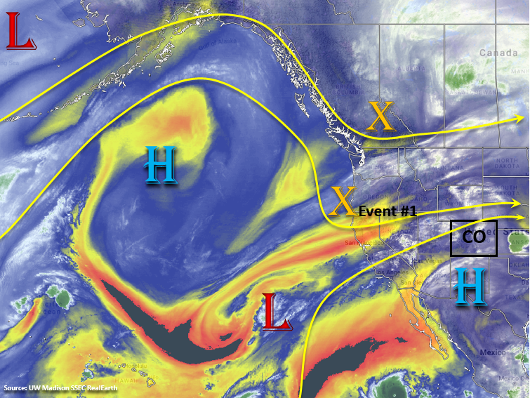
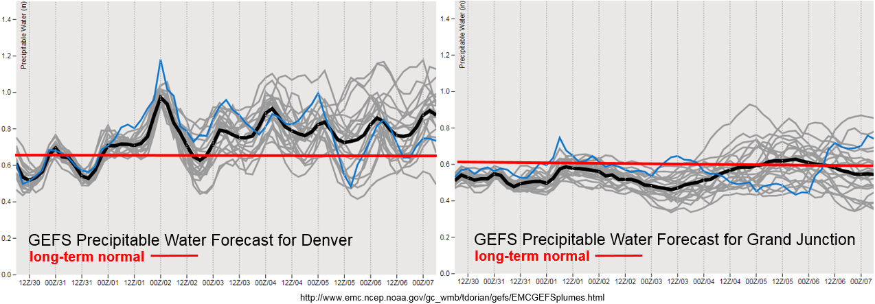
Therefore, we expect a more active holiday weekend in terms of showers and thunderstorms when compared to this week. Today there will be elevated fire danger across the northwest corner of the state with stronger winds mixing to the surface and low relative humidity values. By Friday, low-level moisture increases over the San Juan Mountains, which means there is a chance for some weak showers and thunderstorms along and near the Continental Divide. PW values are anticipated to stay below 0.75 inches, so there is No Apparent Flood Threat. Looking at the PW values over Grand Junction, at this time, it doesn’t seem that the higher moisture will make it too far north. So although there may be an increase in cloud cover over the Central and Northern Mountains, the possibility for wetting rains is low. However, with increased shortwave activity, an isolated storm or two is possible over the Central Mountains. Moisture is on the rise east of the Divide as well, so some high-based storms are possible during the afternoon.
On Saturday, PW values look to increase quite a bit over eastern Colorado with southeasterly surface winds returning behind the front. However, shallow moisture return and dry air entrainment may be possible looking at the water vapor imagery above and using a persistent forecast. Expecting storms to form over the mountains in the early afternoon hours and move east throughout the afternoon and evening. Storm motion at this time is forecast to be fairly slow, so there may need to be an increase for the flood threat on Saturday. However, details in instability will be important as high clouds are expected behind the front. The lack of knowledge in the details means No Apparent Threat is issued, but please tune back into the FTB on Saturday as an upgrade is possible. The increase in subtropical moisture over the southwest corner of the state is short-lived, so not expecting much (if any) rainfall after Friday.
Into next week, model members really start to diverge from one another. For western Colorado, the chances for afternoon rainfall will be low, though an isolated, weak storm is possible over the higher terrains during the afternoon hours. Moisture should stay high enough that there will be a higher chance for isolated showers and thunderstorms over the eastern high terrains each afternoon. Low-level moisture will be the key ingredient, which will need to assessed each morning. So please tune back into the FTO on Monday as model guidance will likely come into more agreement by then. Scroll below to read more details about the identified precipitation events of this FTO.
Event #1: Friday (8/31) – Tuesday (9/4)
No Apparent Threat as post-frontal upslope flow and upper dynamics combine for showers and thunderstorms over the holiday weekend.
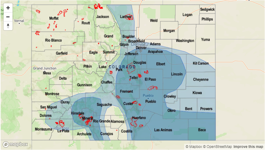
Southwesterly flow aloft will return to the forecast starting tomorrow, which will increase low-level moisture from west to east across the state. Friday, some isolated storms are possible over the eastern San Juan Mountains with high-based storms likely over eastern Colorado. At this time there is No Apparent Threat as storms should be far enough east to not track over the 416/Burro burn scars. Saturday looks to be the most active day of the weekend with surface southeasterly flow returning low-level moisture behind the front. Forecasting storms to return to the eastern high terrains and track eastward throughout the afternoon and evening. Slow steering winds may create problems over the recent burn scars in the Southeast Mountains. Please tune back into the FTB on Saturday for more details. Sunday looks to be a bit quieter, though some isolated storms over the eastern high terrains are possible. Starting next week, models diverge quite a bit from one another. However, moisture looks to remain high enough east of the Divide for isolated afternoon storms over the higher terrains each afternoon.

Event #2: Friday (9/7) – Sunday (9/9)
No Apparent Threat as another trough digs over the west coast and returns low-level moisture with southwesterly flow.
While there is not much confidence in this forecast, I thought it might be worth mentioning that another trough may move over the west coast into the Great Basin at the end of next week. By Thursday, models show a ridge building over the state. On Friday, the ridge shifts eastward as a trough approaches from the west. This could increase southwest flow and moisture, which would upturn the chances for rainfall once again from Friday through Sunday. There is little to no confidence in the forecast, so no precipitation map has been created. Please tune back into Monday’s FTO as models will likely come to more agreement or at least start trending toward a similar solution.