Issue Date: Monday, September 3rd, 2018
Issue Time: 1:20 PM MDT
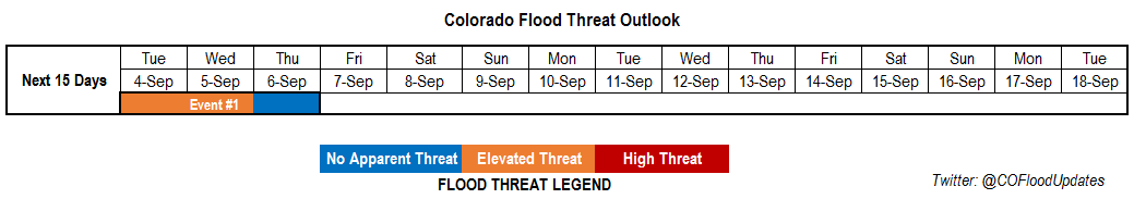
Valid Dates: 9/4 – 9/18
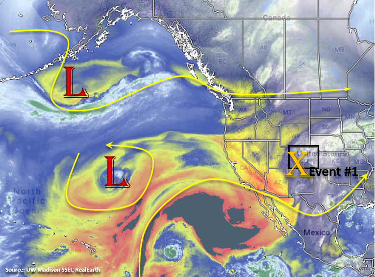
Quite an interesting pattern in the water vapor imagery below. Colorado is caught between the flow to the north and south, so weak steering winds aloft are forecast for the first part of this FTO. Currently, an upper-level trough is over the four corners and will continue to influence the weather over the next couple of days with slow movement to the northeast. Extra energy with this upper-level low will help make afternoon showers more widespread and help continue the chances for storms after sundown. Over the next couple of days, upslope flow will continue, which will bring afternoon showers and thunderstorms into the forecast (Event #1). A cold front is expected to move through the area on Tuesday evening, which may help trigger some stronger storms over the eastern plains with increased convergence and should help moisten the low-levels for another round of afternoon storms on Wednesday over the higher terrains. Some snow may even be possible over the highest elevations on Wednesday evening. Also seen in the water vapor imagery is a lot of dry air (yellow, orange and black). This drier air is expected to move into the state starting Friday, which should start to limit the chances for rainfall this weekend into next week. Westerly flow aloft increases starting Monday, so stronger dry air entrainment and downsloping winds should keep measureable rainfall chances low for the start of next week. There are quite a few differences between the GEFS members after mid-next week, so there will only be one FTO event for this forecast.
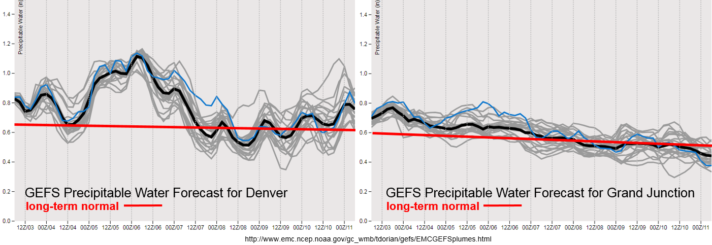
Should be an active start to the week. While flow aloft is quite weak, it remains from the southeast, which will allow upper-level shortwaves to rotate through the state each day. Low-level moisture will also remain high over the eastern plains with southeasterly surface flow. PW values are expected to be well above average through Thursday as seen in the GEFS PW plumes below. Tuesday afternoon, northerly flow near the Front Range is expected produce a line of convergence over the Northeast Plains where it meets the southeasterly surface flow. This will allow some stronger storms to develop over the eastern plains in a high moisture environment. With slow steering winds aloft, heavy rainfall will be possible. A cold front pushes through the state on Tuesday evening and the GEFS shows PW values to increase over eastern Colorado well above the 90th percentile for this time of year. Thus, an Elevated Flood Threat has been issued for the next two days.
By Thursday, moisture begins to decrease and flow aloft on Friday turns more northwesterly. Throughout the weekend, the flow becomes more northerly, which starts the entrainment of the dry air seen in the water vapor imagery above. A small disturbance may cause some isolated showers on Sunday as it passes through the state, but with low-level moisture on the decrease, minimal rainfall is expected with the high-based storms. Monday through Wednesday of next week, entrainment of the dry air with westerly flow aloft should bring PW values much closer to average for this time of year. Some high-based, isolated storms are possible over the higher terrains though measurable rainfall should remain nominal.
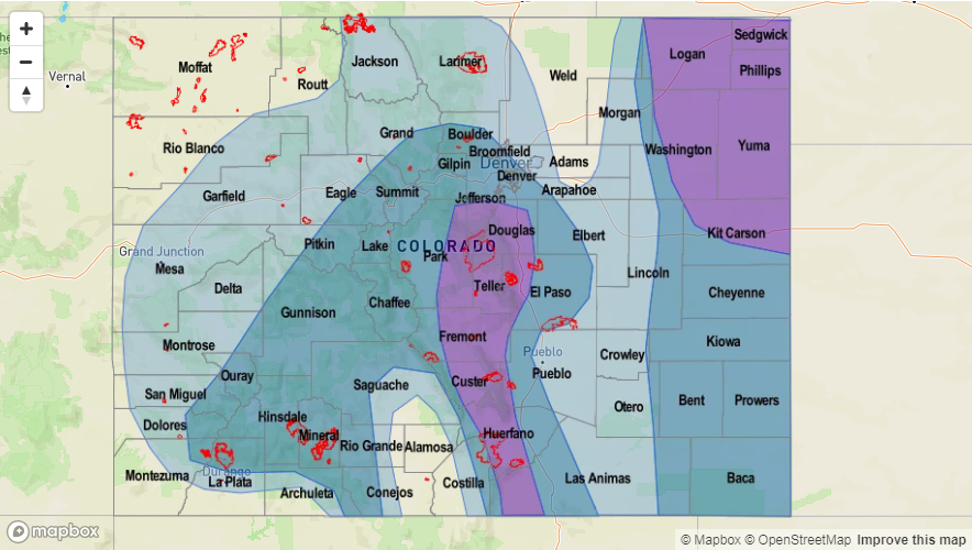
Over western Colorado, moisture steadily decreases over the next week. So outside the slight chance for a Low threat over the 416/Burro burn scars tomorrow, flooding is not expected. Wednesday, some lighter rainfall is possible over the higher terrains though it will become more isolated in nature. Starting Sunday, PW values are forecast to be under 0.5 inches. Models are currently showing the upper jet setting up along the CO/WY border at this time. This may bring back fire danger to the northern portion of the state if the stronger winds mix down to the surface, especially over the Northwest Slope and Northern Mountains. More on this in Thursday’s FTO. Scroll below to read more details about the lone event of this FTO.
Event #1: Tuesday (9/4) – Thursday (9/6)
Elevated/No Apparent Threat as PW values remain near and above the 90th percentile over eastern Colorado the next couple of days.
Weak southwesterly flow aloft will keep an active weather pattern over the state, and it will allow multiple shortwaves to rotate through each day. If timed correctly, these shortwaves may help produce more widespread storm action. Southeasterly surface flow over the eastern plains should keep high low-level moisture in place with weak steering winds aloft through Thursday. On Tuesday, a cold front will drop through the state and convergence along the front will allow some stronger storms to develop over the eastern plains. These storms could produce mildly severe weather and heavy rainfall that may cause flooding issues for local streams and low-lying roads. Post-frontal upslope flow on Wednesday will likely create some heavy rainfall pockets over the Front Range and Southeast Mountains. Threats include mud flows, debris slides and local stream flooding with recent burn scars being extra vulnerable. Although moisture starts to decrease on Thursday, another round of afternoon storms over the higher terrains is possible. The most likely area for storms is over the Southeast Mountains, which will again expose recent burn scars to a potential flood threat. Please check back to the FTB each day this week for a more detailed forecast.