Issue Date: Thursday, September 6th, 2018
Issue Time: 1:15 PM MDT
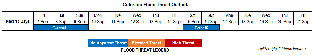
Valid Dates: 9/7 – 9/21
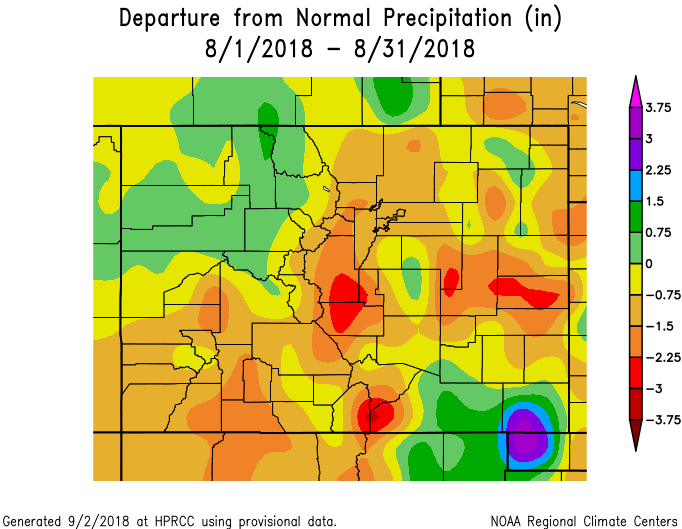
Before starting the FTO, we’re going to take a quick look at August precipitation and temperature compared to normal across the state. The image below shows the Northwest Slope and Southeast Plains receiving quite a bit of rainfall. The more than average Northwest Slope rainfall was likely due to multiple systems clipping the northern border, while the above average precipitation over Baca and Las Animas was due to a couple systems that dropped heavy rainfall. Temperatures for August (not shown) were below average over eastern Colorado, which makes a lot of sense due to the active weather pattern and lots of mornings with a stratus deck. Western Colorado was above average with the Grand Valley, Southwest Slope and western Central Mountains 3-4F above normal.
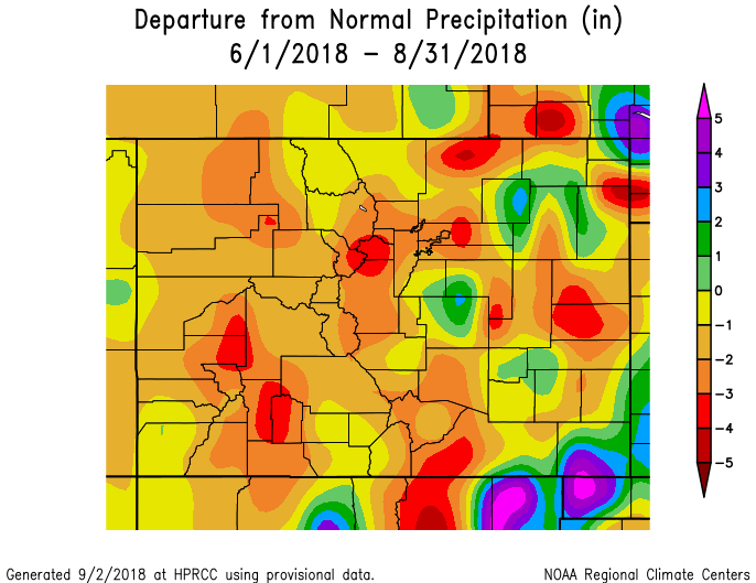
The second image below shows the departure from normal precipitation from June 1st – August 31st, which covers the main portion of the monsoon season. Despite above average precipitation over the Northwest Slope in August, overall precipitation is 1 to 3 inches below normal for the season. That’s likely due to not too many monsoon moisture surges making it that far north. Generally, and discussed before, it was a slow monsoon season for western Colorado. There were only a couple classic monsoon setups, which is why precipitation is about 3 to 4 inches below normal in these areas. Over eastern Colorado, Gulf of Mexico moisture was present more from June through August (comparatively), thus there are some pockets of above normal precipitation for the season. Overall, the Southeast Mountains and Front Range (along with all mountain areas) were quite dry, which helped support an active fire season.
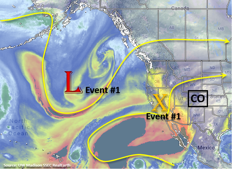
The broad upper-level trough mentioned in Monday’s FTO continues to influence the weather over Colorado and is marked in the water vapor imagery below. The extremely dry air has started to make its way into AZ and Mexico, which will come into play next week. Overall, still experiencing some weak steering winds, which paired with high low-level moisture of the state has caused a couple of days of heavy rainfall. For Friday into Saturday (Event #1), the upper-level trough begins to move east and the Colorado light northwesterly flow aloft becomes much stronger. This, paired with a bit more dry air, will keep flood chances low this weekend. On Saturday into Sunday, some residual moisture under the ridge will likely spark some overnight showers associated with the passing trough in the mountains and then another round of afternoon thunderstorms over the higher terrains.
Westerly flow takes over on Monday as a weak ridge/zonal pattern begins to build over the state. Expecting some cooler temperatures to start the work week as cold front passes through the state behind the trough. Downsloping winds aloft will promote drying through the start of next week and start to push the higher moisture east. Mid-week, upper-level flow will turn southwesterly as a positively tilted trough builds over the west coast and Pacific Northwest. This will continue to entrain a dry air mass from the southwest (AZ/NM), so next week should be fairly quiet as far as rainfall. Fire danger will likely increase with higher temperatures and low relative humidity as well. Some stronger surfaces winds over the northwest corner of the state on Wednesday and Thursday could cause critical fire weather. Please tune back into the FTO on Monday for more details. The GFS is still showing the west coast trough moving through the state next weekend (Event #2), but at this time there is low confidence in this solution as well as with availability of low-level moisture for heavy rainfall.
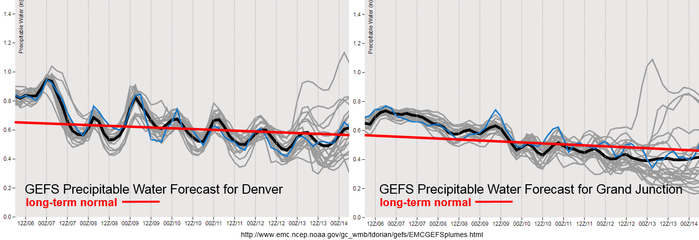
Low-level moisture drops off quite a bit over eastern Colorado on Friday, with less of a decrease over western Colorado. With this, we should see a downtick in storm activity over the higher terrains with little to no flood threat. With slow steering winds, burn scar flash flooding is still a concern over the southern high terrains, so please tune into the FTB tomorrow for a more in-depth analysis. Slight increase in moisture for Saturday night both east and west of the Continental Divide associated with the passing trough. This should cause an uptick in storm activity and may provide some light overnight precipitation in the mountains. Then, the drying trend begins through next week. Denver returns to more seasonal PW values with Grand Junction dropping to below average later in the week. Thus, after Saturday, there is little to no threat for flooding.
Event #1: Friday (9/7) – Sunday (9/9)
No Apparent Threat as the upper-level trough begins to move eastward and brushes the northern border of Colorado.
Storm activity on Friday is expected to decrease as more dry air in entrained into the state. The best chance for afternoon storms will be over the southern high terrains. Flooding is not expected at this time, though recent burn scars may be vulnerable due to slower steering winds. On Saturday, moisture increases some with the passing trough. At this time, not expecting too much instability, but there will likely be an increase in afternoon storms over the northern high terrains with a couple stronger thunderstorms possible. Faster steering winds aloft should help to decrease the flood threat. There is also a potential for rainfall over the eastern plains as the system moves eastward and continues to provide upper-level support for some thunderstorms. Sunday, not expecting much rain, but some residual moisture may trigger a couple isolated storms over the southern high terrains. Storms will likely be confined along and near the Continental Divide. Due to the entrainment of drier air, storms that do form this weekend will have the potential for some gusty outflow winds and also produce dangerous lightning.

Event #2: Saturday (9/15) – Sunday (9/16)
No Apparent Threat as the second trough moves eastward from a nearly stationary position next week.
Again, little to no confidence in this forecast, but it looks like the next trough will still move eastward sometime next weekend. This will likely increase moisture over the state and could cause an uptick in storm activity after a week of negligible rainfall. Not much confidence in mid- and low-level moisture either, so there is No Apparent Threat at this time. There is still too little confidence in the forecast to produce a precipitation map. Just like last week, please tune back into Monday’s FTO as models will likely come to more agreement or at least start trending toward a similar solution.