FTO 05-23-2019: Break in Rainfall with Warm Temperatures Forecast to Start the Holiday Weekend

Issue Date: Thursday, May 23rd, 2019
Issue Time: 11:45PM MDT
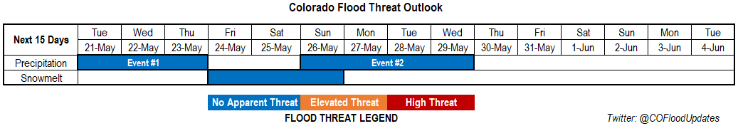
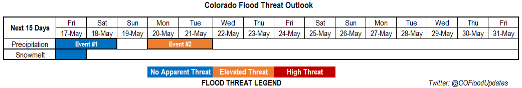
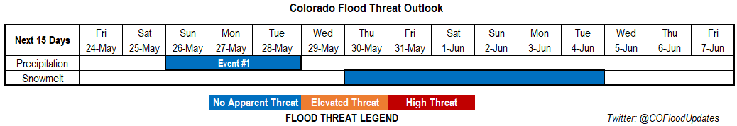
Valid Dates: 5/24 – 6/7

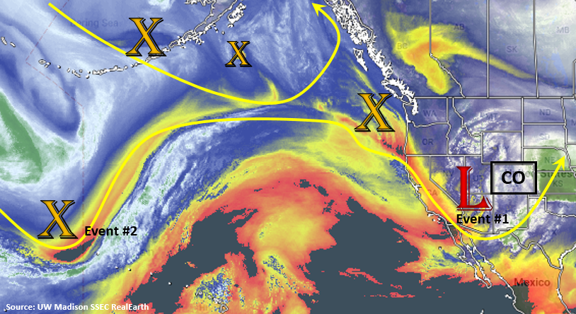
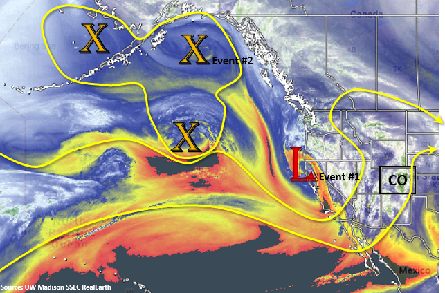
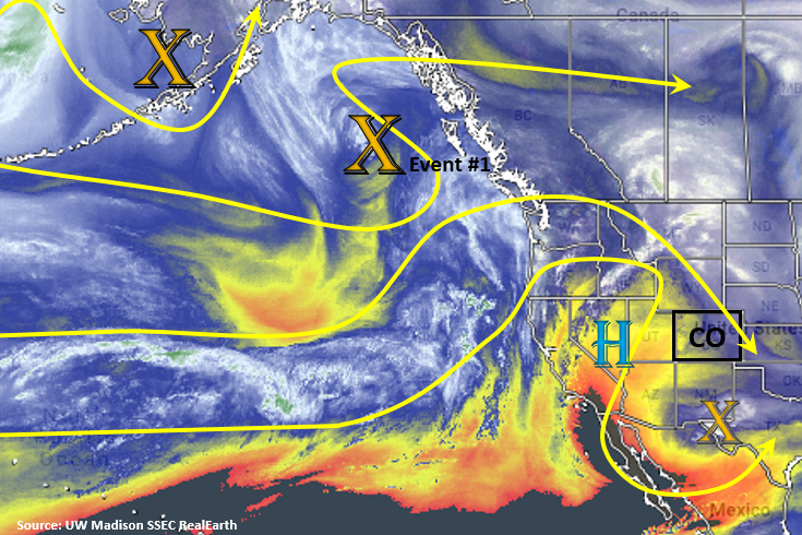
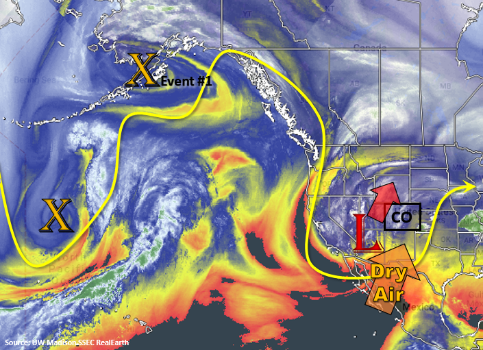
The water vapor imagery below shows the low that will affect our weather today into tonight as it moves swiftly to the northeast. In its wake, dry air will work into the area confining scattered thunderstorms to the higher terrains tomorrow with limited coverage. Saturday, the dry air mass shown with the orange arrow below will be well in place with southwest flow, which should allow only minimal afternoon convection over the mountains. This and the building ridge will also allow temperatures to rebound back into the 70°Fs for the lower elevations. Event #1 begins on Sunday afternoon into Monday as the next trough moves through the state. Over the weekend, this trough will deepen to our west, which will increase southwesterly flow over the state. Currently, the GFS is tracking the system on a more southerly path, similar to Event #1 of the last FTO. This will increase widespread shower and thunderstorm activity Monday into Tuesday with severe weather possible over the far eastern plains on Sunday afternoon. Temperatures are also forecast to cool off on Tuesday as another cold front passes through the state sometime during Monday afternoon or evening. Depending on timing this could also cause severe weather over the eastern plains. With cooler temperatures on Tuesday into Tuesday night, expect rain to turn to snow in the high country at a lower elevation.

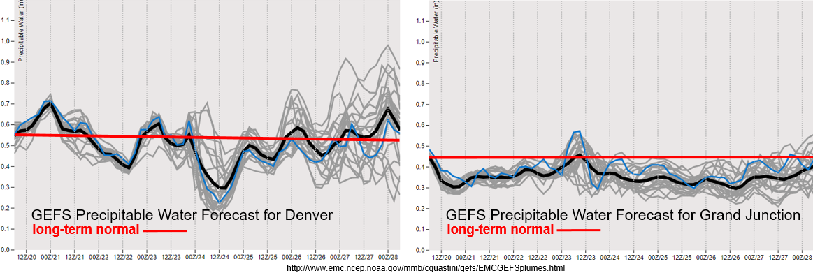
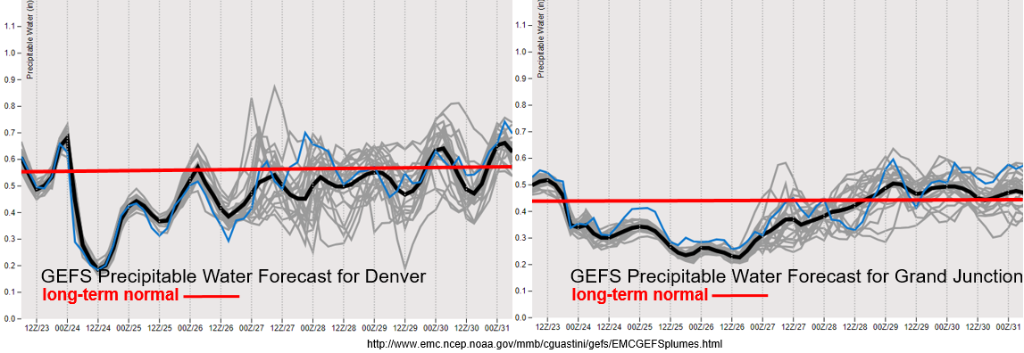
Below the GEFS Precipitable Water forecasts for Denver (left) and Grand Junction (right) show dry air filling in very quickly after the current system passes. This will allow temperatures to rebound tomorrow into the weekend with only an isolated threat for PM thunderstorms over the higher terrains. On Memorial Day, PW rebounds to near normal values, which should cause the uptick in storm activity. Event #1 looks to be warmer than the last two troughs, so snow will likely only occur on Tuesday over the mountains due to the passage of the cold front. Near normal (black line vs red line), PW is expected through the end of the week, though some spread is noted. This should keep scattered showers and thunderstorms in the forecast for the mountains, but widespread rainfall is not forecast.

Snowpack:

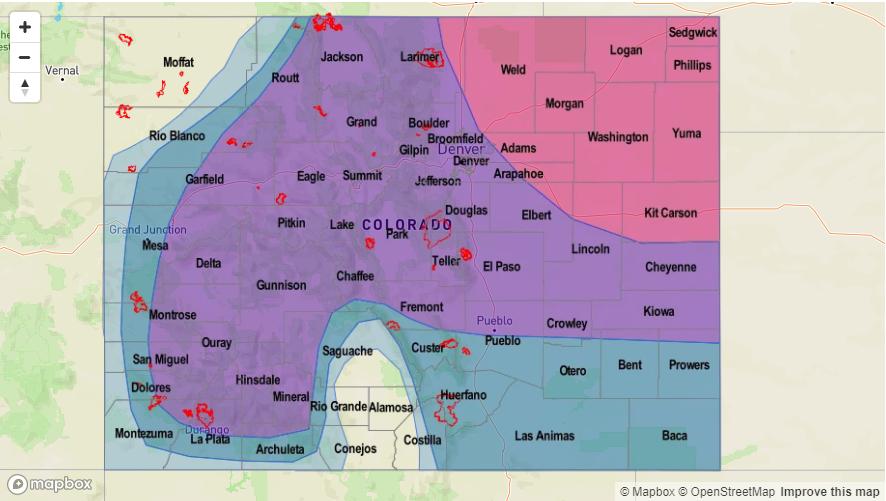
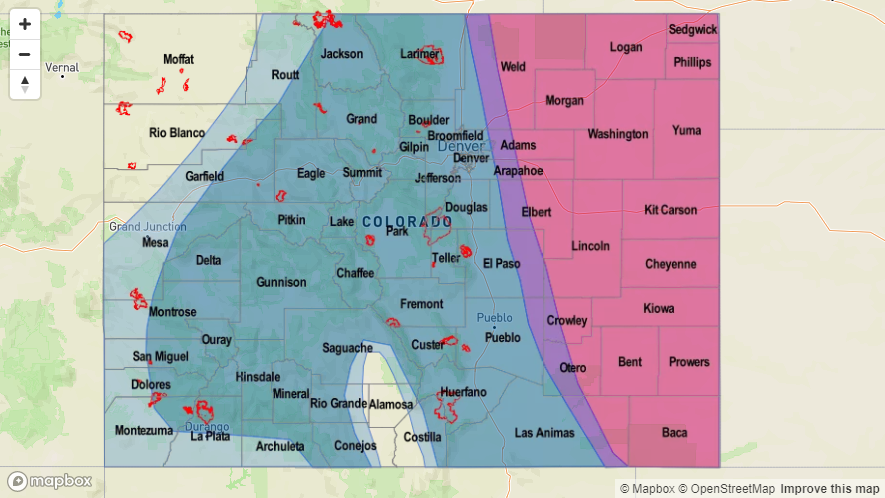
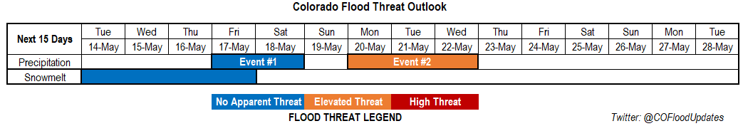
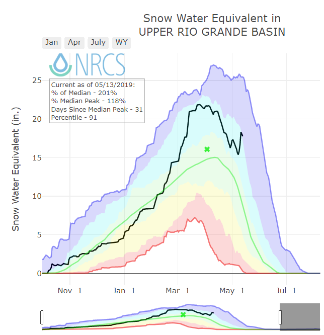
Cold air continues to reside over the state, which has stopped the melt out of the snowpack this week. Most gages have retreated from the Action Stage and snowfall has likely increased the SWE. At the current date, we are 159% of normal snowpack statewide, which is slightly inflated due to the late melt out. While there will be some heating this weekend, there won’t be enough consecutive days of heating to cause any serious melting. After Event #1, the amplified trough/ridge pattern seems to slow down. With more seasonable temperatures and an increasing ridge or zonal pattern forecast over the area, melting should increase by the end of next week. At this time, there is No Apparent Threat due to the drop off in gages this week.

Event #1: Sunday (5/26) – Tuesday (5/28)

No Apparent Threat for widespread rainfall Monday and Tuesday as the next trough moves across the state.

Sunday afternoon, a shortwave trough is noted in the GFS over the eastern plains that is semi associated with the approaching trough. Should this occur in an area with higher dew points (the dry line in Colorado), there is a chance for isolated severe weather over the southeast corner of the state. Large hail and strong winds would be the main threat with local, heavy rainfall possible. Monday, moisture, mid-level ascent and the left exit region of the jet should return widespread showers and thunderstorms to the forecast. A cold front is forecast to drop through the state on Monday evening, which could cause severe weather over the Northwest Plains. This will be watched closely, although there is low confidence this far out. Showers continue Tuesday favoring the Front Range for the highest accumulations due to post-frontal upslope flow. With PW values near climatology, widespread flooding is not forecast. It may be possible for some local heavy rainfall over the adjacent and eastern plains, so please tune back into the FTO on Monday.

Legend

FTO 05-20-2019: Persistent West Coast Troughs Continue the Unsettled Weather Pattern and Promote Cold Temperatures to Start the Week

Issue Date: Monday, May 20th, 2019
Issue Time: 1:10PM MDT
Valid Dates: 5/21 – 6/4

Very cold and unsettled weather to start the week. The low pressure system located to our west will continue to move into southeast Colorado this evening, which should keep widespread showers and snowfall going through Tuesday afternoon and evening (Event #1 pt1). Heaviest precipitation amounts are expected to be over the northeast quadrant of Colorado with snow overnight along the Palmer Ridge. After the low moves to our east on Tuesday, a second vorticity maximum drops south and returns southwesterly flow into the area (Event #1 pt2). So there will be brief pause in precipitation before this next system moves in on Wednesday and Thursday. As with the last systems, precipitation will start over western Colorado and move eastward on Wednesday and Thursday. Temperatures aren’t quite as cold either with this next wave, so snow should be limited to the highest terrains. On Thursday afternoon, severe weather may be possible over the eastern plains as models indicate a dry line setting up over the Southeast Plains.

The next system (Event #2) occurs as another vorticity maximum makes its way around the omega block seen in the water vapor imagery below. This will form another trough to the west that will affect the state at the beginning of next week. Models indicate an uptick in moisture beginning on Sunday evening and lasting through Wednesday. The best chance for widespread rainfall will be on Monday and Tuesday as the low traverses north of Colorado.

Below is the GEFS Precipitable Water forecasts for Denver (left) and Grand Junction (right). PW remains below climatology (0.45 inches) for the next week over western Colorado, so expect storms and showers to continue to be high-based. This means less rainfall making it to the surface with some gusty winds possible under the stronger storms. For Denver, after Tuesday you can start to see a slight downtick in moisture until Event #1 pt2 comes into play. Overall, there is no heavy rainfall threat for Event #1. For Event #2, the GEFS shows large uncertainty in PW over eastern Colorado. This is common a week out, but at this time there is No Apparent Flood threat for Event #2. The PW anomaly will continued to be monitored closely with updates added to Thursday’s FTO.

Cold air really put a cork in the melt out of the snowpack the last couple of days. With colder air arriving tonight and the chilly, unsettled atmospheric pattern in place, not expecting much melting the next week or so. There is a warm up to more climatological values at the end of this week, so some melting during the day may cause small rivers to start to rise. However, melting will be limited with overnight lows still hovering around freezing. There is no threat of riverine flooding at this time.

Event #1: Tuesday (5/21) – Thursday (5/23)

No Apparent Threat as ongoing showers and snow are forecast the next couple of days.

Ongoing showers and snow are expected tonight into tomorrow associated with the low over Nevada/Utah. Tomorrow, the low should be located over the southeast plains near the border and move toward the northeast throughout the day. This should continue rain and snow through the afternoon hours over the northeast quadrant of the state with the wrap around precipitation. A lull in precipitation is likely until the next trough arrives on Wednesday though some storms will likely pop up over the mountains tomorrow afternoon. Not too much low level moisture associated with this next system, and it looks to be a bit warmer, so snow should be confined to the highest terrains. On Thursday, models indicate a dry line setting up over the eastern plains. This could bring some severe weather to the area; however, the exact placement of the dry line is hard to nail down this far out. Possible threats include large hail, strong winds and a possible tornado. With PW values well below the 1 inch mark, flooding is not expected.

Legend

Event #2: Sunday (5/26) – Wednesday (5/29)

No Apparent Threat as unsettled weather continues with another trough to the west.

After a warm up over the weekend, storms return to the forecast at the beginning of next week. Expecting this system to mostly cause accumulation in the mountains, though some heavier rain and severe weather could be possible over the adjacent plains during the afternoon and evening hours if timing lines up. Temperatures continue to look to be a lot warmer with this system (relative to the current one), so  snow should be confined to the highest terrains. The jets pulls the system to the northeast fairly quickly, so widespread flooding is not anticipated. As for the daily threat there is still a lot of spread in PW from the models, but at this time we will forecast no flood threat.

Legend

FTO 05-16-2019: Active Spring Pattern Continues into Next Week

Issue Date: Thursday, May 16th, 2019
Issue Time: 1:30PM MDT
Valid Dates: 5/17 – 5/31

Today’s SSEC RealEarth water vapor imagery continues to show a very dynamic and lively upper level pattern. Event #1 is taking shape as the west coast trough begins to slowly move eastward. By Friday, the upper trough will be located just to our west. As the image shows, not a lot of low level moisture in the area or around the low, so not expecting flooding with this system. By Friday afternoon, a lee trough will set up over eastern Colorado. With the dry line setting up east of this feature, storms over the mountains and adjacent plains should be high-based, which will limit accumulation. There is a slight chance for a couple severe thunderstorms over the Northeast Plains associated with convergence on the northwest side of the surface low. The chance for storms continues into Saturday as a cold front returns some low level moisture during the morning and a second shortwave passes through during the day from west to east. Widely scattered storms (snow and rainfall) are forecast over the mountains and adjacent plains, but severe weather is unlikely and accumulations are expected to stay under flood threat criteria.

Event #2 starts to form over the Gulf of Alaska with the conglomeration of several vorticity centers. This will form another trough that will affect the state at the beginning of next week. The latest runs of the GFS are placing a surface low over the Colorado, New Mexico and Oklahoma border. With cooler temperatures, this could mean some heavy snowfall for the Front Range and rain for the adjacent plains, so an Elevated Threat has been issued. Still plenty of time for the low to shift north or south, which would modify the areas of greatest accumulation. Also, the snow level will be monitored closely as this would also impact the threat level. Tuesday, showers and snow are likely to continue until the system pushes east. Please tune into Monday’s FTO and FTB for evolving details.

With multiple cold fronts moving through the state over the next week or so, there should be a brief pause in the melt out of the snowpack. Small streams will start to approach bankfull today and tomorrow, but the impending cool weather should allow surface levels to begin to drop starting on Saturday. Some warming is expected after Event #2, but with an active pattern expected, melting is not expected to accelerate for long or cause any major flooding issues.

Event #1: Friday (5/17) – Saturday (5/18)

No Apparent Threat as the next trough moves eastward from the west coast.

Moisture has started to slightly increase today with the approaching system and will continue to do so as the trough traverses east. Tomorrow, chances increase for rain and thunderstorms with some snow possible at the highest elevations. In the morning a line of storms will develop with a wave over western Colorado. With southwest steering winds, the storms will favor the Front Range as the wave travels eastward. Enhanced convergence and moisture along the Cheyenne Ridge will allow some higher amounts to fall over the northern Urban Corridor and Front Range. A couple severe thunderstorms are also possible over the Northeast Plains tomorrow afternoon on the northwest side of the surface low. Max 1-hr rain rates up to 0.8 inches may be possible with these storms. Saturday, cooler temperatures should produce snow or cold rain over the higher terrains and rainfall from weak thunderstorms over the adjacent eastern plains. Flooding is not expected.

Legend

Event #2: Monday (5/20) – Tuesday (5/21)

Elevated Threat as the active pattern continues and produces a surface low over the Colorado/New Mexico border.

Still lacking confidence in the details of this next pattern. This is mainly because slight movements in the low and changes to temperatures will impact where and how accumulations forms. However, widespread precipitation is forecast to start next week as the next trough forms to the west. With the current GFS track, the highest accumulations from this system will be over the Front Range, Urban Corridor and Palmer Ridge. The Northern Mountains will also likely have some decent accumulation with the current, more southern track. Hard to tell how much the cold front on Tuesday will cool things off, so can’t nail down the freezing level quite yet. However, if the majority of the precipitation can fall as snow on Tuesday, the Elevated Flood threat will be limited to Monday.

Legend

FTO 05-13-2019: Gorgeous Week Ahead with Storm Chances Increasing into this Weekend

Issue Date: Monday, May 13th, 2019
Issue Time: 11:30PM MDT
Valid Dates: 5/14 – 5/28

Cool start to the month of May across the state with the active pattern. Precipitation totals have also been above average for the higher terrains. The last weather system temporarily stopped the spring melting and added to the already high snowpack with the Central, Southeast and San Juan Mountains receiving the bulk of the snow accumulation. See the Upper Rio Grande Basin’s SWE (Snow Water Equivalent) below. With above average temperatures expected at the beginning of this week, we should start to see the melting of the snowpack pick back up at the higher elevations. At this time, flooding outside of minor flooding of small streams, is not expected.

Below is the SSEC RealEarth water vapor imagery from UW Madison, which shows a very active pattern lining up over the North Pacific. Currently, there is cutoff vorticity max over Texas and New Mexico mentioned in the last FTO. This should stay well south of the state as the high pressure begins to build in from the west. With residual moisture under the ridge, weak thunderstorm activity over the higher terrains is possible each afternoon with the diurnal heating pattern. Event #1 begins as the two vorticity maximums combine (marked X’s in the North Pacific) and a large trough moves in over the west coast and pushes east. Flow aloft will switch to southwesterly on Thursday, which should pull in drier air seen in the image below and limit precipitation chances. Higher moisture is expected on Friday as the ridge slides east, and a front on Saturday should help return low level moisture to the plains. This is expected cause an uptick in thunderstorm activity.

A lull in the pattern occurs Sunday into Monday before the next trough moves in from the west coast (Event #2; not marked above). The GFS is showing a trough west of Colorado at the beginning of next week, which could bring widespread rainfall to western Colorado. While, PW values aren’t looking too impressive at this time, multiple rounds of rain and a melting snowpack could cause some flooding issues. Still quite a bit of time for the details of this system to develop, but there is an Elevated Threat issued for this FTO.

Event #1: Friday (5/17) – Saturday (5/18)

No Apparent Threat as a trough moves eastward from the coast bringing favorable dynamics to area for severe thunderstorms.

Moisture will start to increase towards the end of the week as the trough moves eastward and sits west of Colorado. This will increase the chances of rain and thunderstorms to start next weekend. Saturday, models are showing a cold front drop through the plains, which may increase low level moisture. The GEFS moisture plumes are also indicating an increase in PW values out east. With plentiful lift and dynamics during the afternoon, paired with the moisture return, severe thunderstorms may be possible on Saturday over eastern Colorado. Activity Saturday night is also possible over the eastern plains if upper dynamics align properly. Mostly this would be isolated and associated with an overnight MCS in a boarding state. This could cause some very heavy rainfall totals near the Colorado/Kansas/Nebraska borders should activity spill back to the west. Please tune back in on Thursday for an update as the No Apparent Threat may be upgrade for Saturday.

Legend

Event #2: Monday (5/20) – Wednesday (5/22)

Elevated Threat as a slow moving trough sits to the west of Colorado next week.

Again, lacking confidence in the details of this next pattern, but widespread precipitation may be possible for western Colorado at the beginning of next week if the nearly stationary trough plays out. With snowpack high and temperatures rising, there could be a threat for some minor flooding. At this time, there is an Elevated Flood threat. However, if low level moisture is lacking and rainfall is gradual enough, flooding may not be an issue. Please tune back into the FTO on Thursday for evolving details.

Legend