Issue Date: Thursday, May 16th, 2019
Issue Time: 1:30PM MDT
Valid Dates: 5/17 – 5/31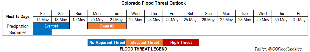
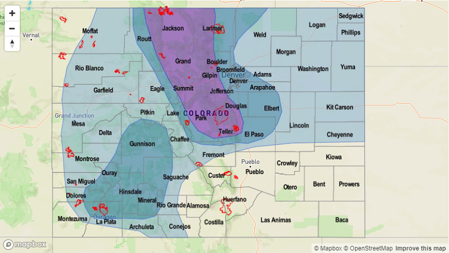
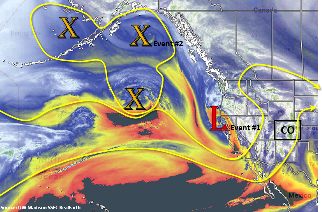
Today’s SSEC RealEarth water vapor imagery continues to show a very dynamic and lively upper level pattern. Event #1 is taking shape as the west coast trough begins to slowly move eastward. By Friday, the upper trough will be located just to our west. As the image shows, not a lot of low level moisture in the area or around the low, so not expecting flooding with this system. By Friday afternoon, a lee trough will set up over eastern Colorado. With the dry line setting up east of this feature, storms over the mountains and adjacent plains should be high-based, which will limit accumulation. There is a slight chance for a couple severe thunderstorms over the Northeast Plains associated with convergence on the northwest side of the surface low. The chance for storms continues into Saturday as a cold front returns some low level moisture during the morning and a second shortwave passes through during the day from west to east. Widely scattered storms (snow and rainfall) are forecast over the mountains and adjacent plains, but severe weather is unlikely and accumulations are expected to stay under flood threat criteria.
Event #2 starts to form over the Gulf of Alaska with the conglomeration of several vorticity centers. This will form another trough that will affect the state at the beginning of next week. The latest runs of the GFS are placing a surface low over the Colorado, New Mexico and Oklahoma border. With cooler temperatures, this could mean some heavy snowfall for the Front Range and rain for the adjacent plains, so an Elevated Threat has been issued. Still plenty of time for the low to shift north or south, which would modify the areas of greatest accumulation. Also, the snow level will be monitored closely as this would also impact the threat level. Tuesday, showers and snow are likely to continue until the system pushes east. Please tune into Monday’s FTO and FTB for evolving details.
With multiple cold fronts moving through the state over the next week or so, there should be a brief pause in the melt out of the snowpack. Small streams will start to approach bankfull today and tomorrow, but the impending cool weather should allow surface levels to begin to drop starting on Saturday. Some warming is expected after Event #2, but with an active pattern expected, melting is not expected to accelerate for long or cause any major flooding issues.
Event #1: Friday (5/17) – Saturday (5/18)
No Apparent Threat as the next trough moves eastward from the west coast.
Moisture has started to slightly increase today with the approaching system and will continue to do so as the trough traverses east. Tomorrow, chances increase for rain and thunderstorms with some snow possible at the highest elevations. In the morning a line of storms will develop with a wave over western Colorado. With southwest steering winds, the storms will favor the Front Range as the wave travels eastward. Enhanced convergence and moisture along the Cheyenne Ridge will allow some higher amounts to fall over the northern Urban Corridor and Front Range. A couple severe thunderstorms are also possible over the Northeast Plains tomorrow afternoon on the northwest side of the surface low. Max 1-hr rain rates up to 0.8 inches may be possible with these storms. Saturday, cooler temperatures should produce snow or cold rain over the higher terrains and rainfall from weak thunderstorms over the adjacent eastern plains. Flooding is not expected.

Event #2: Monday (5/20) – Tuesday (5/21)
Elevated Threat as the active pattern continues and produces a surface low over the Colorado/New Mexico border.
Still lacking confidence in the details of this next pattern. This is mainly because slight movements in the low and changes to temperatures will impact where and how accumulations forms. However, widespread precipitation is forecast to start next week as the next trough forms to the west. With the current GFS track, the highest accumulations from this system will be over the Front Range, Urban Corridor and Palmer Ridge. The Northern Mountains will also likely have some decent accumulation with the current, more southern track. Hard to tell how much the cold front on Tuesday will cool things off, so can’t nail down the freezing level quite yet. However, if the majority of the precipitation can fall as snow on Tuesday, the Elevated Flood threat will be limited to Monday.