FTO 08-29-2019: Hot and Mostly Dry Labor Day Weekend

Issue Date: Thursday, August 29th, 2019
Issue Time: 1:50PM MDT
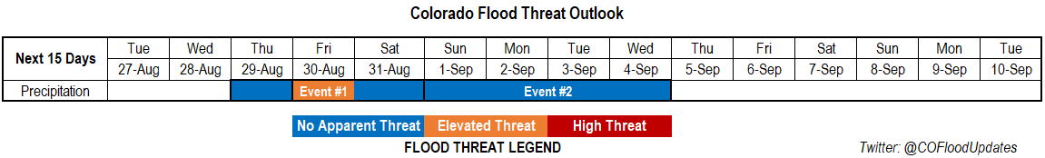
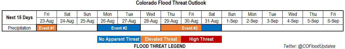
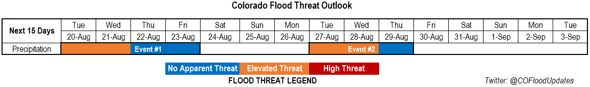
Valid Dates: 8/30 – 9/13

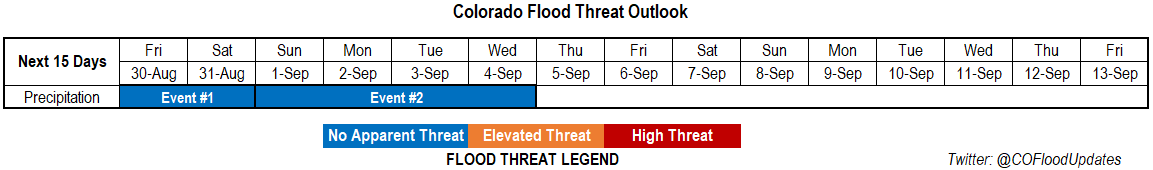
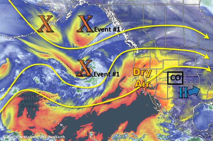
Event #1 is currently underway with a weak cold front moving through eastern Colorado associated with the passage of a trough. Easterly surface flow behind the front should start to return moisture to the area for more measurable rainfall on Friday. Guidance not indicating deep or widespread moisture return at this time. With steering flows between 15 and 20 mph and most of the eastern plains capped, there is No Apparent Threat for flooding. Some low level moisture hangs on through Saturday, but as the ridge begins to rebuild over the state, storms should be rather isolated in nature with only isolated pops over the southern high terrains forecast. Gusty winds and lightning are expected to be the main threats.

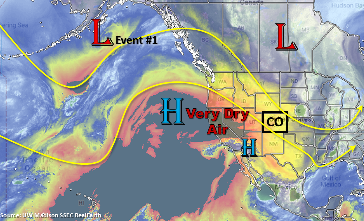
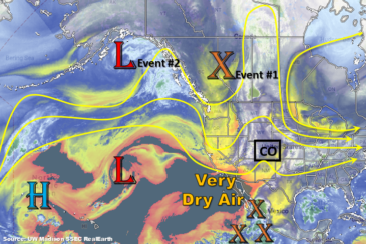
The ridge remains overhead until the next trough starts to move into the Pacific Northwest on Monday. The dry air over the western US seen below moves into western Colorado by Monday, which limits measurable rainfall chances and returns fire danger. The passing trough returns some moisture to Northeast Plains and Urban Corridor behind a cold front on Tuesday. Thus, Tuesday will be the best chance for measurable rain with Event #2. On Wednesday, it looks like some moisture could sneak into the southwest corner of the state, which would return showers and thunderstorms to the San Juan Mountains and higher elevations of the Southwest Slope. At this time, there is No Apparent Threat for flooding.

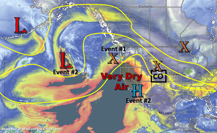
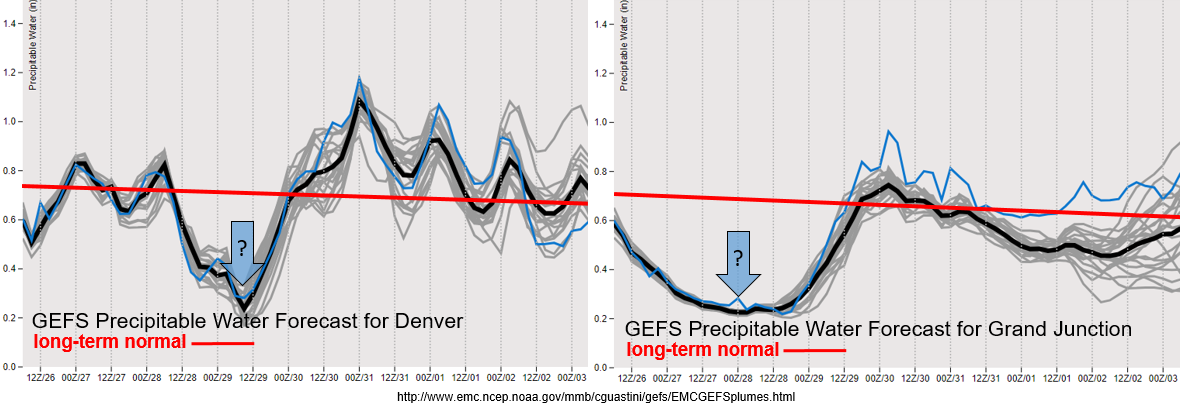
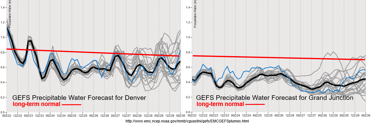
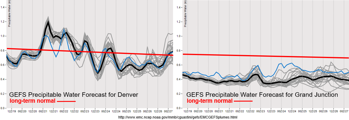
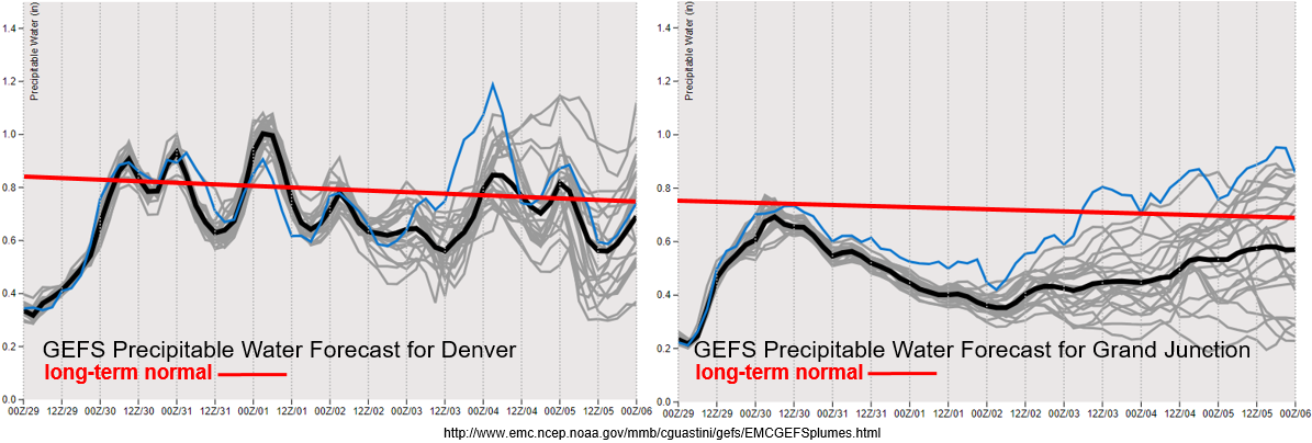
Recovery of near record low PW values over Denver has begun with easterly surface flow behind the cold front. PW values return to more seasonable values through Sunday with hot temperatures anticipated statewide until the cold front drops through on Tuesday. At that point, there is quite a bit of spread in PW values by model members due to the uncertainty of the strength of Event #2. Doesn’t look to be a large surge of moisture even with the worst case scenario, so at this time there is No Apparent Threat. Over western Colorado, moisture begins to return this afternoon with the passing trough, but quickly begins to drop back off. That means there will be elevated fire danger through this weekend, which could last through the mid-next week. It does look like the jet stays well to our north, so critical fire weather may be avoided. Passing shortwaves will be monitored each day as they could help spark some dry thunderstorms or periods of gusty surface winds.

Event #1: Friday (8/30) – Saturday (8/31)

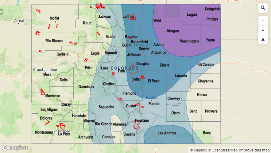
No Apparent Threat as surface winds behind a cold front promotes moisture to return to the state from the east for afternoon scattered showers.

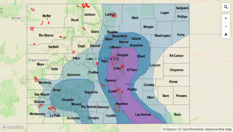
Moisture return still looks to be greatest on Friday, but the threat level has dropped off quite a bit. This is due to more confidence the eastern plains will be capped. Best moisture looks to be east of I-25 tomorrow afternoon, so burn areas over the Southeast Mountains should be in good shape. Of course, if the details change – for example the plains no longer looked capped, they will be highlighted in tomorrow’s FTB. A couple severe storms tomorrow can’t be ruled out over the Palmer Divide with gusty winds as the main threat. With steering flows at 15 to 20 mph, the heavy rainfall threat is limited in coverage. Saturday, the ridge begins to build back to the north, so expected unseasonably warm temperatures once again through Monday. A pretty good cap looks to be over the state, so just expecting some weak, isolated storms over the southern high terrains, which includes the Raton Ridge.

Legend

Event #2: Sunday (9/1) – Wednesday (9/5)

No Apparent Threat with the best chance for measurable rainfall on Tuesday and Wednesday.

Should be a quiet Labor Day weekend and holiday as the very dry air mass shifts into western Colorado Sunday into Monday. The growing ridge will promote some very hot temperatures as well, so be sure to take that into account for activities on Monday. Not much residual moisture under the ridge for widespread storms driven by diurnal flow, but there may be enough for some isolated, weak storms each afternoon over the mountains. Temperatures cool off and rain returns to the forecast on Tuesday with the passage of the next cold front. The best chance for measurable rain and thunderstorms will be over the Urban Corridor and Northeast Plains. On Wednesday, guidance is indicating a slight PW surge over the southwest corner of the state. This would return afternoon showers to the San Juan Mountains, and if it occurs, could be problematic for the 416 burn area. Hopefully there is adequate moisture or dry thunderstorms could be the other alternative, which would raise fire concerns. Low confidence in the forecast details this far out with the weak system, so be sure to tune back in to the FTO on Monday.

Legend

FTO 08-26-2019: Couple Day Break in Hot Temperatures before Heat & Storms Return

Issue Date: Monday, August 26th, 2019
Issue Time: 1:00PM MDT
Valid Dates: 8/27 – 9/10

Event #3 of Thursday’s FTO has now become Event #1. There will be one more day (Tuesday) with northwest flow over the state, which will push another cold front through and give way to slightly below average high temperatures. By Wednesday, the 500mb ridge begins to rebuild over the western US, which will mark the next warm up. Temperatures will likely bounce back to the 90°Fs over the lower elevations before the next trough pushes through on Thursday. Looking for rain to return to the forecast first over western Colorado (Thursday) and then to the eastern mountains on Friday and Saturday. Not expecting widespread, heavy rainfall at this time, but rainfall amounts could cause issues for recent burn areas. The best moisture return will be on Friday behind the next (slightly weaker) cold front, so an Elevated flood threat to be issued for this day. Rainfall chances begin to decrease on Saturday as the ridge rebuilds with the best chance for accumulation over the Southeast Mountains and Raton Ridge. Not currently thinking there will be a threat to burn areas over the Southeast Mountains on Saturday, but a lot can change this far out in a forecast.

Event #2 immediately follows Event #1, which begins as a western Colorado event and transitions to the Front Range and Northeast Plains Wednesday and Thursday. Mid-level energy rotating around the high and a PW surge to our east will cause rainfall to return to the western high terrains. The bulk of the moisture looks to be west of the state to begin, but as the ridge axis is pushed slightly eastward by the next trough, this would push some of that moisture into the state. It looks to be a fairly strong ridge that sets up during Event #2, so expecting abnormally high temperatures again with a moderate diurnal temperature swing.

A very dry air mass (black in the water vapor imagery above) begins to move over the state with the northwesterly to westerly flow aloft the next couple of days. We will come close, and may even set, the daily minimum PW records for Denver and Grand Junction (see the blue arrows below). During this period for Denver, the record is between 0.3 and 0.33 inches and for Grand Junction, the record is between 0.25 and 0.27 inches. Thankfully, surface winds aren’t looking to be too strong, so widespread, critical fire weather is not anticipated at this time. Quite the moisture return east and west of the Continental Divide behind the front. Still not quite sure about the depth of the moisture, so this will be something to watch. Nonetheless, storms should reappear in the forecast beginning on Thursday.

Event #1: Thursday (8/29) – Saturday (8/31)

Elevated Threat/No Apparent Threat as a passing trough pushes the ridge axis east and allows moisture to return to the state behind a cold front for afternoon scattered storms.

This event will first begin over western Colorado on Thursday and then transition to the eastern mountains on Friday (and possibly Saturday). Moisture return looks highest behind the front on Friday, so this is when the greatest heavy rainfall threat will be. Models have been decreasing the intensity of the trough over our state the last few days, but a lot of details could change the couple of days. Not too worried about widespread flooding, but rain rates could be high enough to cause issues over the recent burn areas. Please tune into the FTO on Thursday as there will be much more confidence in a 1-day forecast. It looks to dry out and warm up over the weekend as the ridge builds overhead, so it should be a beautiful Labor Day weekend for camping and outdoor activities.

Legend

Event #2: Sunday (9/1) – Thursday (9/5)

No Apparent Threat due to weak moisture return as the ridging pattern is broken down.

Not a ton of confidence in this forecast due to it beginning a week out, but an active storm pattern looks to return for Event #2. Right now it looks to mainly be a western Colorado event, which would be great since this region has gotten very dry over the last month or so. Unfortunately, there is equal chance that if storms return to the forecast and PW is only around a half inch (see guidance above), dry thunderstorms would cause some fire concerns. Please check back into the forecast on Thursday as it will likely become clearer which scenario will play out.

Legend

FTO 08-22-2019: Severe Storms likely for Eastern CO on Friday, but then Hot Temperatures and Dry Weather Return for the Weekend

Issue Date: Thursday, August 22nd, 2019
Issue Time: 2:00PM MDT
Valid Dates: 8/23 – 9/6

Event #1 of this FTO is a continuation of the Event #1 from the last FTO. There will be one more day with an Elevated flood threat (Friday) as the trough finishes pushing to the east of the state. Mid-level energy, associated with the trough, will combine with high moisture near the CO/KS border, CAPE and a low level jet for some evening, severe thunderstorms. With PW forecast to be around 1.2 inches by that time, heavy rainfall will be possible with these storms along with large hail and gusty winds. We dry out and look rain-free this weekend as flow becomes northwesterly with the high building off the west coast. This will pull in the dry air (yellow colors) to our northwest seen in the water vapor imagery below. Also looking at some very hot temperatures again this weekend, but relief is on the way Monday when a cold front pushes through.

Not much moisture associated with the front (Event #2), though there will likely be some scattered storms over the high terrains behind the front on Monday and Tuesday. Cooler temperatures should help keep the plains stable (no storms). So at this time, there is No Apparent flood threat. Another break in rainfall activity on Wednesday as another stronger cold front slides through the state with the stormy, northwest flow pattern. This should keep things stable with the GFS still pushing out high temperatures in the 60°Fs and low 70°Fs. Of course the strength and timing of the front is hard to gage this far out. There looks to be a bit of PW surge over eastern Colorado as the subtropical high attempts to set up over the NM/AZ/TX panhandle region on Thursday and Friday. With more seasonable temperatures, unsure how much CAPE will build and how fast storm motion will be, but for now we’ll go with an Elevated threat.

Not much change to the PW plumes from the last FTO. Denver starts to drop off below climatology PW values after tonight with fairly low PW values through Monday. The model is having a little trouble deciding what the moisture return will be behind the front (spread in the left figure at the end). Either way, likely aren’t looking at values reaching over 1 inch, which is a good indicator of heavy rainfall potential. To the west, it remains very dry. Not good considering the drought has returned over the Northwest and Southeast Slopes. Passing jets and tightening pressure gradients will be watched closely for this area as that will trigger critical fire weather. Could see another Red Flag Warning for tomorrow over the northwest corner of the state as southwest surface winds look to reach the 10 to 20 mph range and relative humidity will be in the teens again. Please check in with the NWS Pueblo office or read the FTB tomorrow for the latest. Winds are forecast to pick back up on Sunday, so there is another chance for critical fire weather then.

Event #1: Friday (8/23)

Elevated Threat the passing trough mixes with favorable thunderstorm dynamics and high moisture over the eastern plains.

A couple severe thunderstorms are likely again tomorrow late afternoon/evening over the eastern plains as storms form over the Palmer and Raton Ridges and move east. Large hail and damaging winds will be the main threats along with heavy rainfall. There is a chance for a tornado over the Northeast corner of the state, but the threat looks to be higher over the Nebraska Panhandle if the cap can break. Storm motion will be more westerly, so the storms that fire on the Cheyenne Ridge should stay in Nebraska. A severe storm is also possible over the Southeast Plains, though heavier rainfall looks to be south and east of the state on the other side of the dryline. Back to the west, storms will be high-based and produce gusty outflow winds and cloud cover rather than heavy rainfall due to dew points in the 20°Fs (east of the dryline). A little better moisture holds on over the CO/NE/WY intersect, so highest totals back to the west are forecast to be here. Not thinking this will need to be more than a Low threat (eastern plains). Confidence is little low that a threat will need to be issued as steering flows are likely going to be fast enough to limit the flood threat.

Legend

Event #2: Monday (8/26) – Tuesday (8/27)

No Apparent Threat with mostly stable conditions behind a cold front.

Behind the passage of a cold front, a little moisture means storms could return to the mountains. The plains look to remain capped with a stable air mass in place. There is a good chance the whole state may only see an increase in cloud cover, which depends on the depth of the moisture return. Either way, there is No Apparent Threat for this event. No map has been draw due to totals remaining under 0.5 inches.

Event #3: Thursday (8/29) – Saturday (8/31)

Elevated Threat/No Apparent Threat as a weak PW surge (possibly) sets up over eastern Colorado.

After what will hopefully be our first glimpse at fall (Wednesday) the subtropical high looks to set up over NM/TX Panhandle/AZ on Thursday. This would pull in some higher PW values over eastern CO. The northwest pattern could easily send shortwaves through the state during the afternoon hours, which could increase the chances for more widespread, heavy rainfall. Severe potential not looking as good since temperatures will limit the amount of CAPE that can build. Steering winds over the eastern plains will also likely keep storms from dropping too much rainfall over one area. However, storms will likely be slow moving over the southern high terrains, which could be problematic for recent burn areas. Time will tell what happens with this event as confidence in a forecast this far out is low.

Legend

FTO 08-19-2019: Elevated Flood Threat for the Next Two Days Before the Drying Trend Begins

Issue Date: Monday, August 19th, 2019
Issue Time: 2:10PM MDT
Valid Dates: 8/20 – 9/3

Event #1 begins tomorrow, which is actually a semi-continuation of today’s weather pattern. The 500mb ridge axis continues to build northward with the center of the high shifting slightly to the west. This will keep temperatures hot again with only some slight cooling indicated by models over the Urban Corridor. A surface low is expected to develop over the far eastern plains (possibly western Kansas), which will pull in high moisture on its east and north side as it wraps around the low in a counterclockwise manner. This should help return high dew points and PW values back to the Northeast Plains. The one question is the depth of this moisture, which will be better answered by tomorrow’s FTB. Meanwhile, some mid-level energy will move across the state from Utah and Wyoming, which will trigger more widespread activity over this moisture rich area. Expecting some severe thunderstorms on Tuesday along with some heavy rainfall due to slow steering winds. A cold front begins to move south over eastern Colorado on Wednesday morning. Post frontal upslope flow will return heavy rainfall chances to the mountains and immediate adjacent plains, which could cause some issues for recent burn areas over the Southeast Mountains. PW values begin to drop off Thursday and Friday as mid-level flow becomes more zonal, so the Elevated threat decreases at that time.

Should be a quiet weather weekend with high PW to our west, east, and south. Tuesday into Wednesday, flow aloft becomes more northwesterly as high pressure begins to build off the Pacific Coast. Models showing a cold front dropping south, and with mid-level energy likely, heavy rainfall chances return. Unsure how deep this moisture return would be behind the front and strength of the steering flow (likely fairly fast), thus the hesitation to go above an Elevated flood threat at this time. Looks like some elevated moisture could sneak in over the southwest corner as well, so we’ll keep an eye on this for the 416 burn area. Overall, Event #2 looks like it might give us a taste of fall.

Climatological PW values looks to decline as the monsoon begins to shut off for the season (red line). There is a strong moisture return for eastern Colorado during Event #1 with PW values in the 90th percentile for this time of year. The forecast below indicates a strong easterly component to the low level winds for the high moisture to make it back to Denver tomorrow afternoon. Keep in mind PW was measured at 0.52 inches in the soundings Monday morning. With slower steering winds forecast for tomorrow afternoon, storms over the Northeast Plains have the potential to drop a lot of rainfall. It also looks like there is potential for some overnight, heavy rainfall for the far northeast corner of the state if the cap is broken. Please tune into the FTB tomorrow for the latest. After Wednesday, moisture looks to decline to below average with a very dry weekend ahead.

To the west, the dry air seen in the water vapor imagery above continues to keep PW values well below average. On Tuesday/Wednesday, PW may increase over the southwest corner, so we’ll be watching that closely. Not thinking there will be much fire weather danger until (perhaps) Event #2. For that event, models are currently placing the jet to our north, so that should keep critical fire weather out of the forecast. However, if this feature sags south at all, there may be a brief window where a Red Flag Warning could be issued. Of course this forecast is for mid to end of next week, so a lot can still change in the details.

Event #1: Tuesday (8/20) – Friday (8/23)

Elevated Threat/No Apparent Threat for a surface low pulling in high moisture over the Northeast Plains and mixing with mid-level energy rotating around the ridge from Utah and Wyoming.

Looking to be another hot one tomorrow with the ridge well in place over the state. A lee cyclone looks to pull in higher moisture to the Northeast Plains. Further south over the eastern plains, better moisture looks to be over Kansas, so the potential flood threat area will be on the smaller side. Northeast Plain’s moisture paired with mid-level energy rotating around the high means there is a chance for some heavy rainfall, but only if the waves are timed correctly and moisture isn’t mixed out. A couple severe thunderstorms would also be likely in this scenario, which would be capable of producing large hail (best guess is 1.75 inches at this time), strong winds and heavy rainfall. Some models indicting storms will continue over the far northeast corner of the state overnight with the low level jet (possibly) kicking in to provide lift. Wednesday, post frontal upslope flow will return the heavy rainfall threat to the mountains. With rain rates likely greater than 0.5 inches, there is the potential for flooding issues over the Spring Creek burn area. Of course this is only if storms track over the scar, so details will be clearer on Wednesday morning. The threat decreases Thursday into Friday with measurable rainfall mainly projected for the eastern mountains and immediate adjacent plains.

Legend


Event #2: Tuesday (8/27) – Thursday (8/29)

Elevated Threat/No Apparent Threat as we potentially get our first taste of fall.

Flow aloft switches back to the northwest for this event, which will send a strong cold front through the state sometime on Tuesday or Wednesday. The GFS is indicating much below average temperatures behind the front at this time, which will feel a lot like fall. There will likely be a quick return of moisture behind the front, which could cause some widespread storms over the eastern plains.  This will only come to fruition if the front passes during peak heating. The reality is, this is probably looking more like an eastern mountains, plus San Juan Mountain, event with some rainfall spilling over into the immediate adjacent plains. Only time will tell if those mid to upper 60°Fs high temperatures verify behind the front on Wednesday. Personally, I’m looking forward to it.

Legend