Issue Date: Thursday, August 29th, 2019
Issue Time: 1:50PM MDT
Valid Dates: 8/30 – 9/13
Event #1 is currently underway with a weak cold front moving through eastern Colorado associated with the passage of a trough. Easterly surface flow behind the front should start to return moisture to the area for more measurable rainfall on Friday. Guidance not indicating deep or widespread moisture return at this time. With steering flows between 15 and 20 mph and most of the eastern plains capped, there is No Apparent Threat for flooding. Some low level moisture hangs on through Saturday, but as the ridge begins to rebuild over the state, storms should be rather isolated in nature with only isolated pops over the southern high terrains forecast. Gusty winds and lightning are expected to be the main threats.
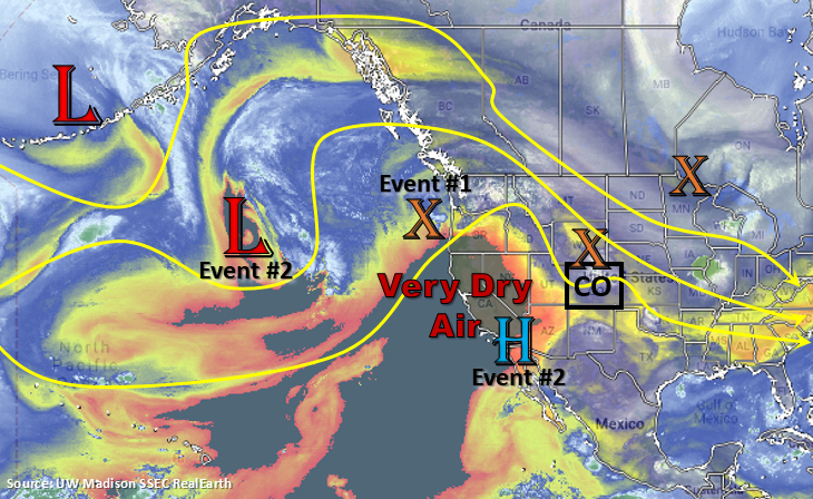
The ridge remains overhead until the next trough starts to move into the Pacific Northwest on Monday. The dry air over the western US seen below moves into western Colorado by Monday, which limits measurable rainfall chances and returns fire danger. The passing trough returns some moisture to Northeast Plains and Urban Corridor behind a cold front on Tuesday. Thus, Tuesday will be the best chance for measurable rain with Event #2. On Wednesday, it looks like some moisture could sneak into the southwest corner of the state, which would return showers and thunderstorms to the San Juan Mountains and higher elevations of the Southwest Slope. At this time, there is No Apparent Threat for flooding.
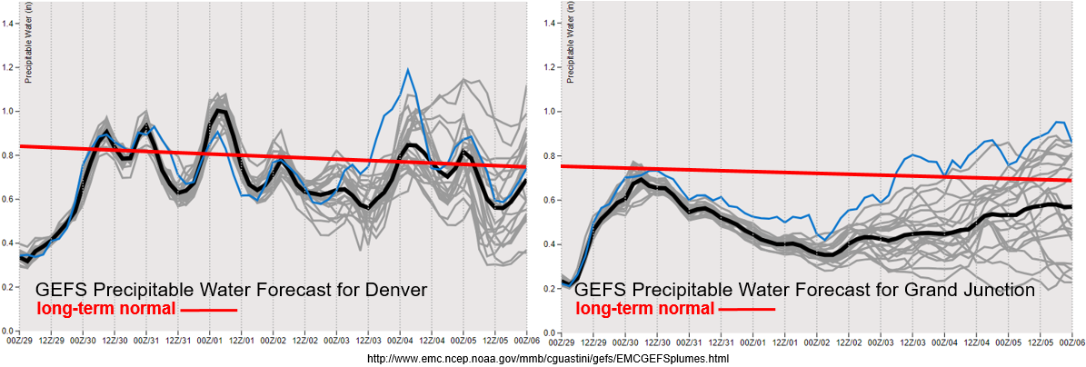
Recovery of near record low PW values over Denver has begun with easterly surface flow behind the cold front. PW values return to more seasonable values through Sunday with hot temperatures anticipated statewide until the cold front drops through on Tuesday. At that point, there is quite a bit of spread in PW values by model members due to the uncertainty of the strength of Event #2. Doesn’t look to be a large surge of moisture even with the worst case scenario, so at this time there is No Apparent Threat. Over western Colorado, moisture begins to return this afternoon with the passing trough, but quickly begins to drop back off. That means there will be elevated fire danger through this weekend, which could last through the mid-next week. It does look like the jet stays well to our north, so critical fire weather may be avoided. Passing shortwaves will be monitored each day as they could help spark some dry thunderstorms or periods of gusty surface winds.
Event #1: Friday (8/30) – Saturday (8/31)
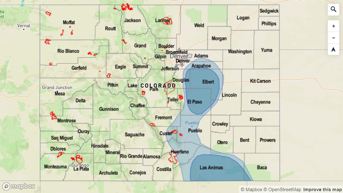
No Apparent Threat as surface winds behind a cold front promotes moisture to return to the state from the east for afternoon scattered showers.
Moisture return still looks to be greatest on Friday, but the threat level has dropped off quite a bit. This is due to more confidence the eastern plains will be capped. Best moisture looks to be east of I-25 tomorrow afternoon, so burn areas over the Southeast Mountains should be in good shape. Of course, if the details change – for example the plains no longer looked capped, they will be highlighted in tomorrow’s FTB. A couple severe storms tomorrow can’t be ruled out over the Palmer Divide with gusty winds as the main threat. With steering flows at 15 to 20 mph, the heavy rainfall threat is limited in coverage. Saturday, the ridge begins to build back to the north, so expected unseasonably warm temperatures once again through Monday. A pretty good cap looks to be over the state, so just expecting some weak, isolated storms over the southern high terrains, which includes the Raton Ridge.
Event #2: Sunday (9/1) – Wednesday (9/5)
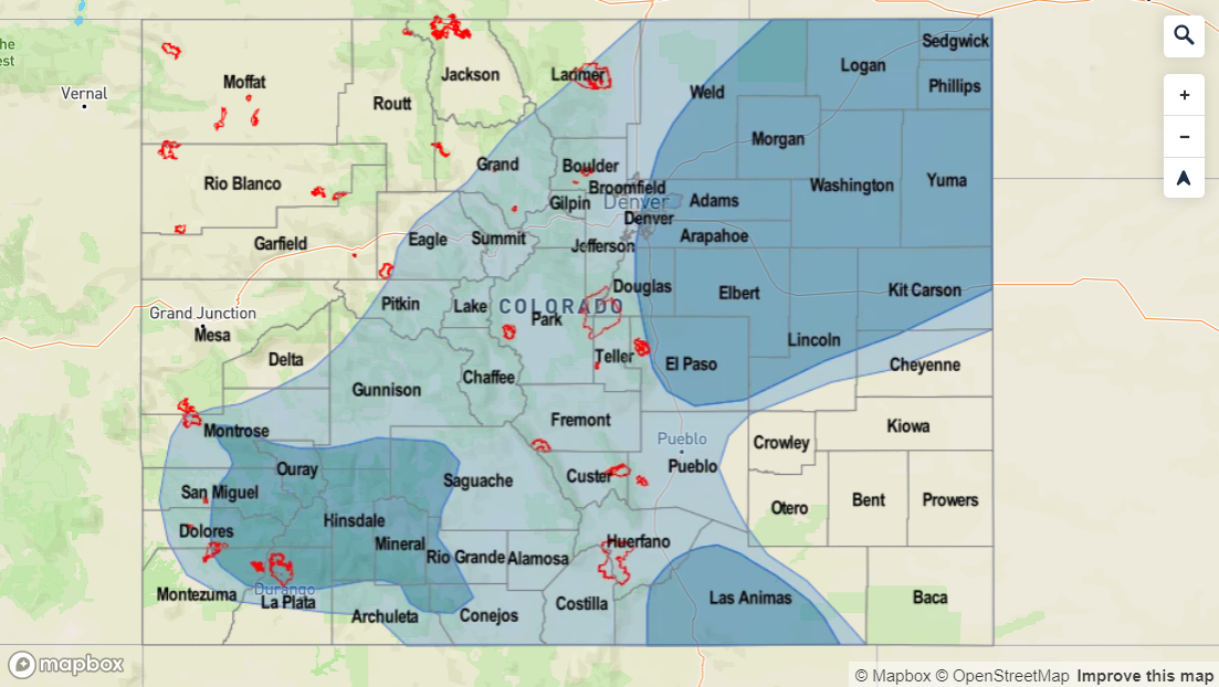
No Apparent Threat with the best chance for measurable rainfall on Tuesday and Wednesday.
Should be a quiet Labor Day weekend and holiday as the very dry air mass shifts into western Colorado Sunday into Monday. The growing ridge will promote some very hot temperatures as well, so be sure to take that into account for activities on Monday. Not much residual moisture under the ridge for widespread storms driven by diurnal flow, but there may be enough for some isolated, weak storms each afternoon over the mountains. Temperatures cool off and rain returns to the forecast on Tuesday with the passage of the next cold front. The best chance for measurable rain and thunderstorms will be over the Urban Corridor and Northeast Plains. On Wednesday, guidance is indicating a slight PW surge over the southwest corner of the state. This would return afternoon showers to the San Juan Mountains, and if it occurs, could be problematic for the 416 burn area. Hopefully there is adequate moisture or dry thunderstorms could be the other alternative, which would raise fire concerns. Low confidence in the forecast details this far out with the weak system, so be sure to tune back in to the FTO on Monday.


