Issue Date: Thursday, August 22nd, 2019
Issue Time: 2:00PM MDT
Valid Dates: 8/23 – 9/6
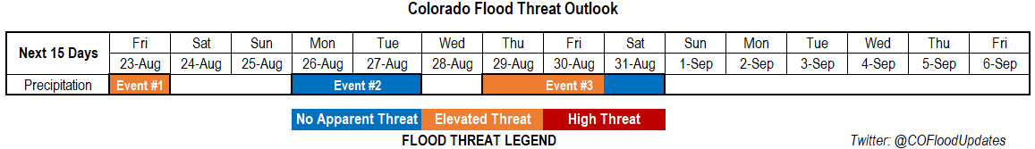
Event #1 of this FTO is a continuation of the Event #1 from the last FTO. There will be one more day with an Elevated flood threat (Friday) as the trough finishes pushing to the east of the state. Mid-level energy, associated with the trough, will combine with high moisture near the CO/KS border, CAPE and a low level jet for some evening, severe thunderstorms. With PW forecast to be around 1.2 inches by that time, heavy rainfall will be possible with these storms along with large hail and gusty winds. We dry out and look rain-free this weekend as flow becomes northwesterly with the high building off the west coast. This will pull in the dry air (yellow colors) to our northwest seen in the water vapor imagery below. Also looking at some very hot temperatures again this weekend, but relief is on the way Monday when a cold front pushes through.
Not much moisture associated with the front (Event #2), though there will likely be some scattered storms over the high terrains behind the front on Monday and Tuesday. Cooler temperatures should help keep the plains stable (no storms). So at this time, there is No Apparent flood threat. Another break in rainfall activity on Wednesday as another stronger cold front slides through the state with the stormy, northwest flow pattern. This should keep things stable with the GFS still pushing out high temperatures in the 60°Fs and low 70°Fs. Of course the strength and timing of the front is hard to gage this far out. There looks to be a bit of PW surge over eastern Colorado as the subtropical high attempts to set up over the NM/AZ/TX panhandle region on Thursday and Friday. With more seasonable temperatures, unsure how much CAPE will build and how fast storm motion will be, but for now we’ll go with an Elevated threat.
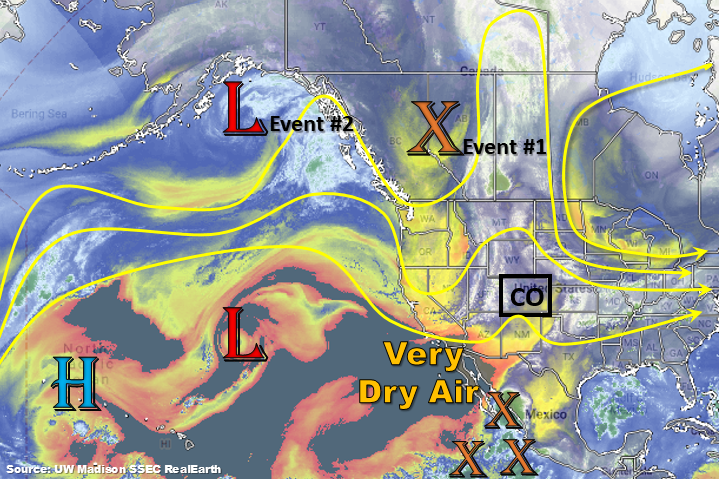
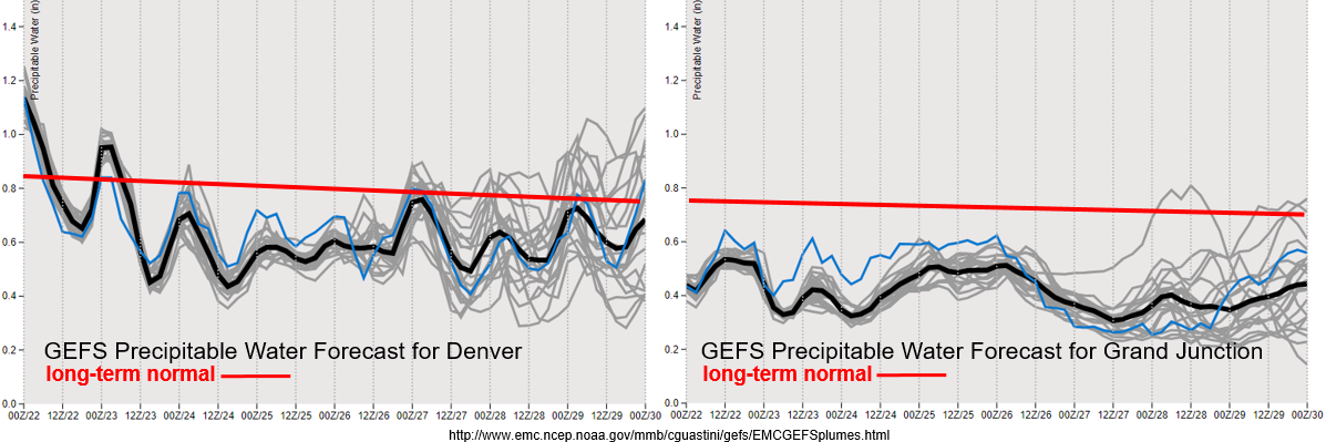
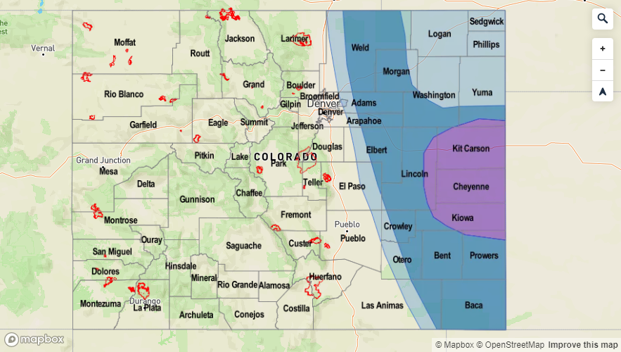
Not much change to the PW plumes from the last FTO. Denver starts to drop off below climatology PW values after tonight with fairly low PW values through Monday. The model is having a little trouble deciding what the moisture return will be behind the front (spread in the left figure at the end). Either way, likely aren’t looking at values reaching over 1 inch, which is a good indicator of heavy rainfall potential. To the west, it remains very dry. Not good considering the drought has returned over the Northwest and Southeast Slopes. Passing jets and tightening pressure gradients will be watched closely for this area as that will trigger critical fire weather. Could see another Red Flag Warning for tomorrow over the northwest corner of the state as southwest surface winds look to reach the 10 to 20 mph range and relative humidity will be in the teens again. Please check in with the NWS Pueblo office or read the FTB tomorrow for the latest. Winds are forecast to pick back up on Sunday, so there is another chance for critical fire weather then.
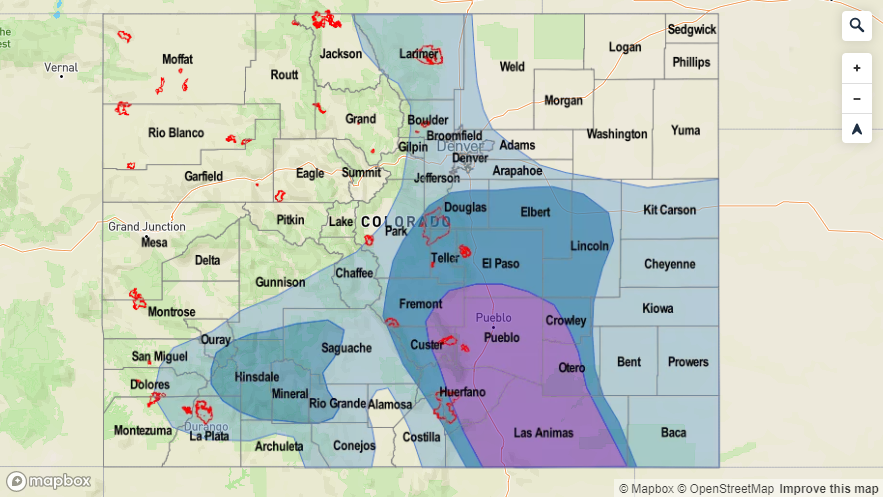
Event #1: Friday (8/23)
Elevated Threat the passing trough mixes with favorable thunderstorm dynamics and high moisture over the eastern plains.
A couple severe thunderstorms are likely again tomorrow late afternoon/evening over the eastern plains as storms form over the Palmer and Raton Ridges and move east. Large hail and damaging winds will be the main threats along with heavy rainfall. There is a chance for a tornado over the Northeast corner of the state, but the threat looks to be higher over the Nebraska Panhandle if the cap can break. Storm motion will be more westerly, so the storms that fire on the Cheyenne Ridge should stay in Nebraska. A severe storm is also possible over the Southeast Plains, though heavier rainfall looks to be south and east of the state on the other side of the dryline. Back to the west, storms will be high-based and produce gusty outflow winds and cloud cover rather than heavy rainfall due to dew points in the 20°Fs (east of the dryline). A little better moisture holds on over the CO/NE/WY intersect, so highest totals back to the west are forecast to be here. Not thinking this will need to be more than a Low threat (eastern plains). Confidence is little low that a threat will need to be issued as steering flows are likely going to be fast enough to limit the flood threat.

Event #2: Monday (8/26) – Tuesday (8/27)
No Apparent Threat with mostly stable conditions behind a cold front.
Behind the passage of a cold front, a little moisture means storms could return to the mountains. The plains look to remain capped with a stable air mass in place. There is a good chance the whole state may only see an increase in cloud cover, which depends on the depth of the moisture return. Either way, there is No Apparent Threat for this event. No map has been draw due to totals remaining under 0.5 inches.
Event #3: Thursday (8/29) – Saturday (8/31)
Elevated Threat/No Apparent Threat as a weak PW surge (possibly) sets up over eastern Colorado.
After what will hopefully be our first glimpse at fall (Wednesday) the subtropical high looks to set up over NM/TX Panhandle/AZ on Thursday. This would pull in some higher PW values over eastern CO. The northwest pattern could easily send shortwaves through the state during the afternoon hours, which could increase the chances for more widespread, heavy rainfall. Severe potential not looking as good since temperatures will limit the amount of CAPE that can build. Steering winds over the eastern plains will also likely keep storms from dropping too much rainfall over one area. However, storms will likely be slow moving over the southern high terrains, which could be problematic for recent burn areas. Time will tell what happens with this event as confidence in a forecast this far out is low.