Issue Date: Monday, August 19th, 2019
Issue Time: 2:10PM MDT
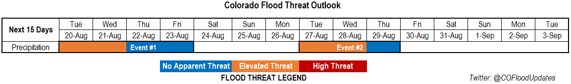
Valid Dates: 8/20 – 9/3
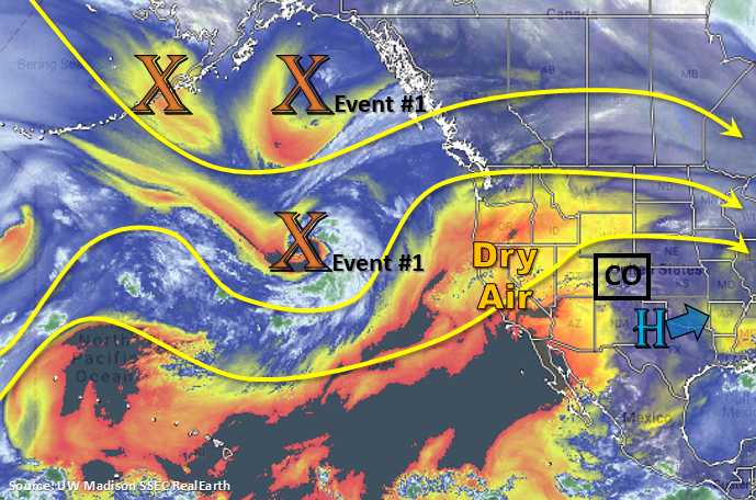
Event #1 begins tomorrow, which is actually a semi-continuation of today’s weather pattern. The 500mb ridge axis continues to build northward with the center of the high shifting slightly to the west. This will keep temperatures hot again with only some slight cooling indicated by models over the Urban Corridor. A surface low is expected to develop over the far eastern plains (possibly western Kansas), which will pull in high moisture on its east and north side as it wraps around the low in a counterclockwise manner. This should help return high dew points and PW values back to the Northeast Plains. The one question is the depth of this moisture, which will be better answered by tomorrow’s FTB. Meanwhile, some mid-level energy will move across the state from Utah and Wyoming, which will trigger more widespread activity over this moisture rich area. Expecting some severe thunderstorms on Tuesday along with some heavy rainfall due to slow steering winds. A cold front begins to move south over eastern Colorado on Wednesday morning. Post frontal upslope flow will return heavy rainfall chances to the mountains and immediate adjacent plains, which could cause some issues for recent burn areas over the Southeast Mountains. PW values begin to drop off Thursday and Friday as mid-level flow becomes more zonal, so the Elevated threat decreases at that time.
Should be a quiet weather weekend with high PW to our west, east, and south. Tuesday into Wednesday, flow aloft becomes more northwesterly as high pressure begins to build off the Pacific Coast. Models showing a cold front dropping south, and with mid-level energy likely, heavy rainfall chances return. Unsure how deep this moisture return would be behind the front and strength of the steering flow (likely fairly fast), thus the hesitation to go above an Elevated flood threat at this time. Looks like some elevated moisture could sneak in over the southwest corner as well, so we’ll keep an eye on this for the 416 burn area. Overall, Event #2 looks like it might give us a taste of fall.
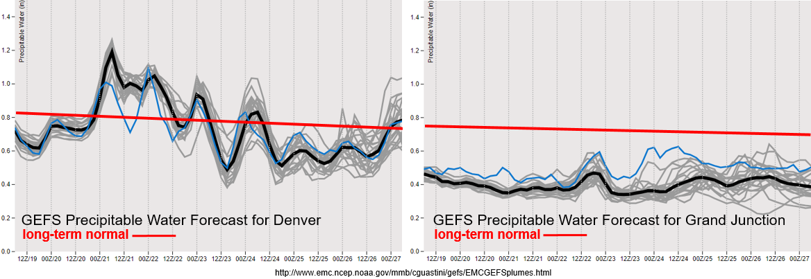
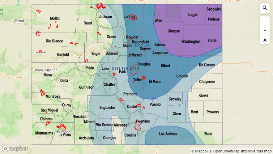
Climatological PW values looks to decline as the monsoon begins to shut off for the season (red line). There is a strong moisture return for eastern Colorado during Event #1 with PW values in the 90th percentile for this time of year. The forecast below indicates a strong easterly component to the low level winds for the high moisture to make it back to Denver tomorrow afternoon. Keep in mind PW was measured at 0.52 inches in the soundings Monday morning. With slower steering winds forecast for tomorrow afternoon, storms over the Northeast Plains have the potential to drop a lot of rainfall. It also looks like there is potential for some overnight, heavy rainfall for the far northeast corner of the state if the cap is broken. Please tune into the FTB tomorrow for the latest. After Wednesday, moisture looks to decline to below average with a very dry weekend ahead.
To the west, the dry air seen in the water vapor imagery above continues to keep PW values well below average. On Tuesday/Wednesday, PW may increase over the southwest corner, so we’ll be watching that closely. Not thinking there will be much fire weather danger until (perhaps) Event #2. For that event, models are currently placing the jet to our north, so that should keep critical fire weather out of the forecast. However, if this feature sags south at all, there may be a brief window where a Red Flag Warning could be issued. Of course this forecast is for mid to end of next week, so a lot can still change in the details.
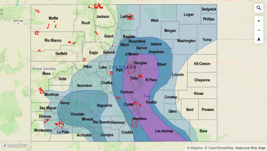
Event #1: Tuesday (8/20) – Friday (8/23)
Elevated Threat/No Apparent Threat for a surface low pulling in high moisture over the Northeast Plains and mixing with mid-level energy rotating around the ridge from Utah and Wyoming.
Looking to be another hot one tomorrow with the ridge well in place over the state. A lee cyclone looks to pull in higher moisture to the Northeast Plains. Further south over the eastern plains, better moisture looks to be over Kansas, so the potential flood threat area will be on the smaller side. Northeast Plain’s moisture paired with mid-level energy rotating around the high means there is a chance for some heavy rainfall, but only if the waves are timed correctly and moisture isn’t mixed out. A couple severe thunderstorms would also be likely in this scenario, which would be capable of producing large hail (best guess is 1.75 inches at this time), strong winds and heavy rainfall. Some models indicting storms will continue over the far northeast corner of the state overnight with the low level jet (possibly) kicking in to provide lift. Wednesday, post frontal upslope flow will return the heavy rainfall threat to the mountains. With rain rates likely greater than 0.5 inches, there is the potential for flooding issues over the Spring Creek burn area. Of course this is only if storms track over the scar, so details will be clearer on Wednesday morning. The threat decreases Thursday into Friday with measurable rainfall mainly projected for the eastern mountains and immediate adjacent plains.

Event #2: Tuesday (8/27) – Thursday (8/29)
Elevated Threat/No Apparent Threat as we potentially get our first taste of fall.
Flow aloft switches back to the northwest for this event, which will send a strong cold front through the state sometime on Tuesday or Wednesday. The GFS is indicating much below average temperatures behind the front at this time, which will feel a lot like fall. There will likely be a quick return of moisture behind the front, which could cause some widespread storms over the eastern plains. This will only come to fruition if the front passes during peak heating. The reality is, this is probably looking more like an eastern mountains, plus San Juan Mountain, event with some rainfall spilling over into the immediate adjacent plains. Only time will tell if those mid to upper 60°Fs high temperatures verify behind the front on Wednesday. Personally, I’m looking forward to it.