FTO 05-11-2020: Brief Pause before Storm Activity Increases Again

Issue Date: Monday, May 11th, 2020
Issue Time: 2:45PM MDT
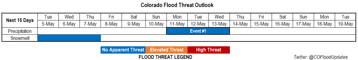
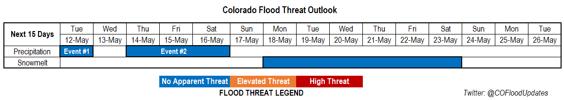
Valid Dates: 5/12 – 5/26

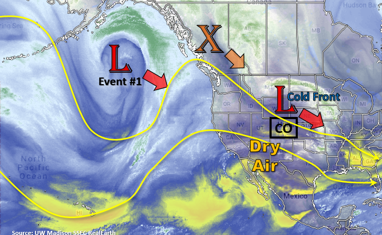
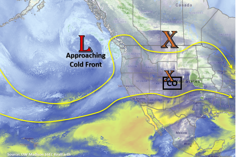
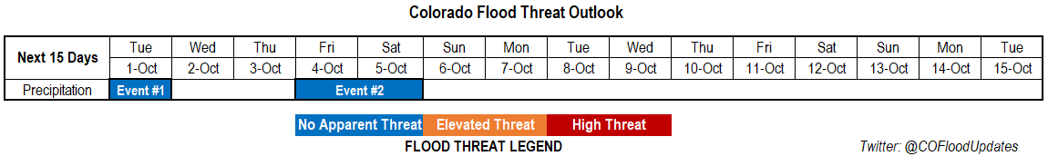
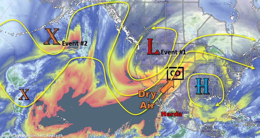
Seen in the water vapor imagery below a nice northward surge of subtropical moisture. This and the shortwave over western/central Colorado are responsible for today and tonight’s precipitation. Not a lot of complaints here as this moisture is very much needed, and the cooler temperatures have been nice change of pace. Some lingering moisture over eastern Colorado and a fast-moving shortwave (lift) will conclude Event #1 tomorrow with isolated afternoon storms forecast. Westerly flow aloft will push the highest moisture (green dashed line) east of the state, so there is No Apparent flood threat.

Flow aloft behind the current shortwave quickly turns southwesterly and begins to advect a dry air mass across the state. This has already prompted a Red Flag Warning for the lower elevations of the Grand Valley and Southwest Slope tomorrow afternoon. A Fire Weather Watch has been issued for the San Luis Valley for Tuesday afternoon as well. Expecting fire danger to remain elevated for these regions through Thursday with a peak and more widespread fire weather on Wednesday for the state.

Event #2 begins on Thursday as the lobe of vorticity over Canada passes to our north and flattens the ridge. A cold front overnight on Wednesday will help return moisture to eastern Colorado for storms on Thursday afternoon. Following this system is the Low off the California coast, which will pass to our north Friday into Saturday. Another passing cold front at this time will keep the low-level moisture in place over northern and eastern Colorado. Additionally, a jet over the northern Colorado boarder will help provide lift for some stronger, more widespread storm activity on Friday. A couple severe storms will be possible over the eastern plains on Thursday and Friday. It will begin to dry out and heat up following this weekend as a strong Low sets up off the coast of California and produces southwest flow, so fire danger is expected to escalate once again.

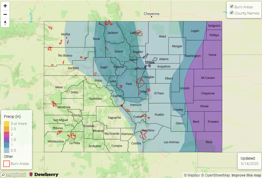
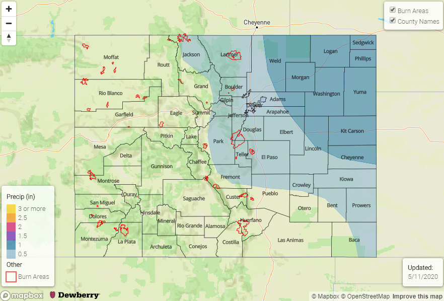
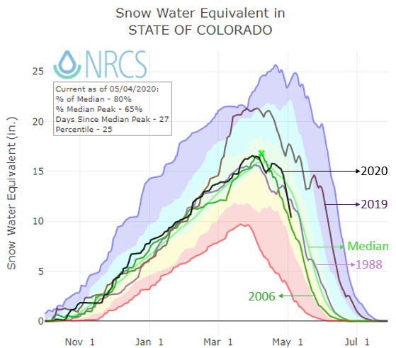
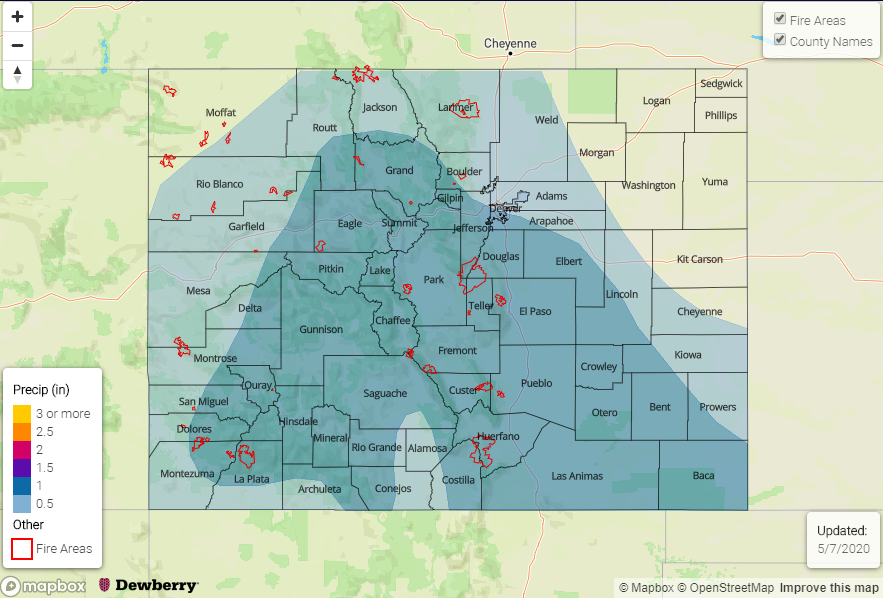
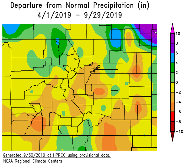
Streamflow over northern and central Colorado will start to increase next week with the warm up. At this time there isn’t any flooding anticipated, and overall large-scale flooding concerns are low this season. Further south, not expecting much more in terms of streamflow increases due to a large majority of the snow pack already being melted and dry soils (less runoff). Both will help keep the threat of riverine flooding very low this season over these regions.

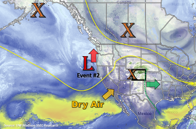
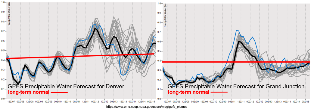
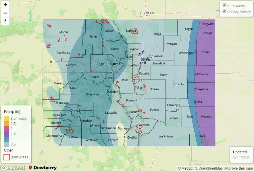
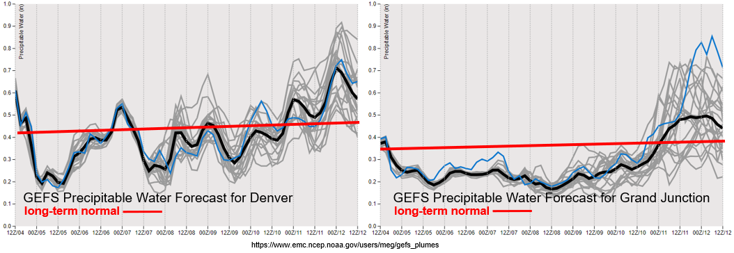
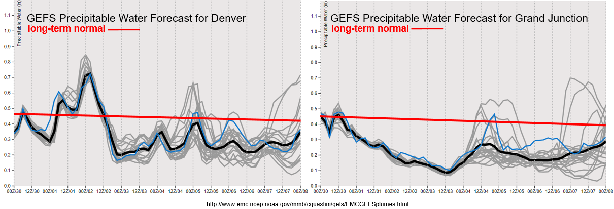
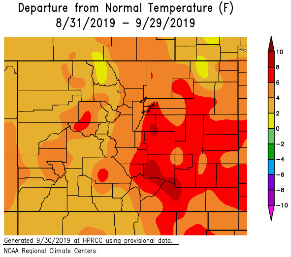
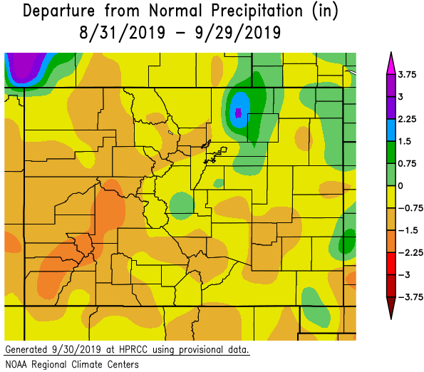
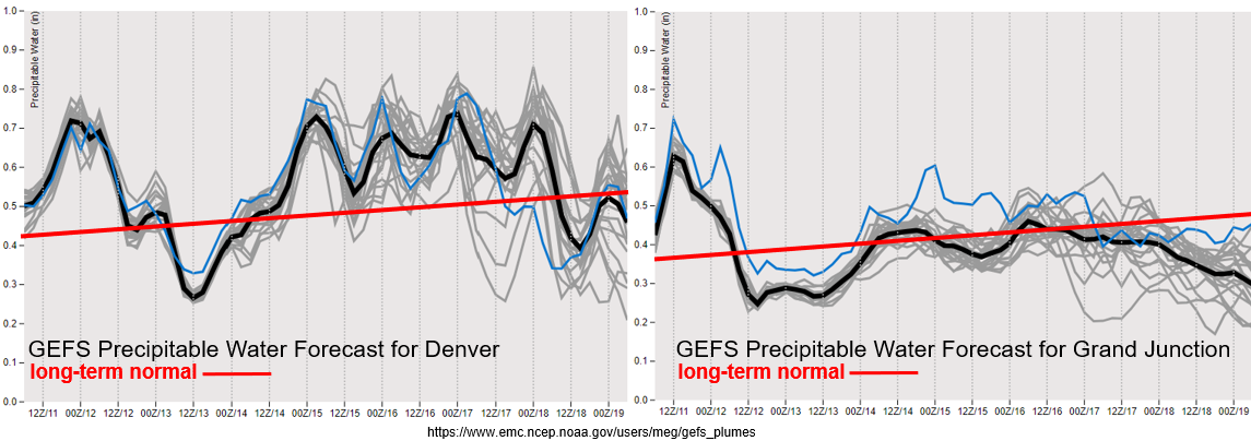
Huge drop off in moisture behind today’s system over western Colorado (right). Hence the uptick in fire danger over the next couple days with increased surface winds forecast. This dry air works into eastern by tomorrow night with the westerly flow, and both areas are below normal when compared to climatology. The passing systems later this week return surface moisture, and therefore storm chances, to eastern Colorado. Western Colorado will remain drier during this same period, although the northern mountains and Northwest Slope may see some light rainfall due to its proximity to the passing systems. Overall, PW values are well under an inch across the majority of the state, so not expecting flooding issues at this time. PW values over the far eastern plains will be watched closely, but at this time they don’t seem to rise much above an inch.

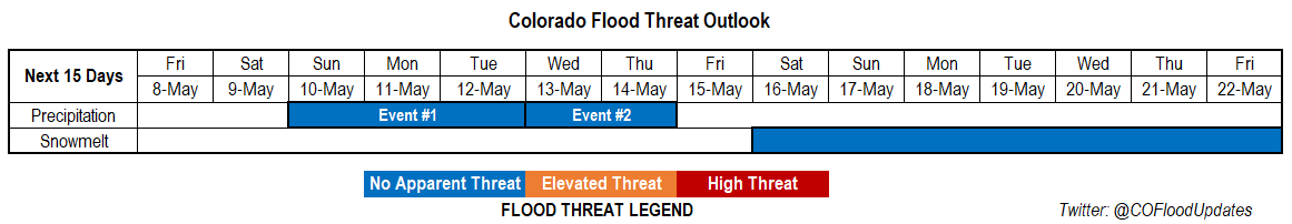
Event #1: Tuesday (5/12)

No Apparent Threat as lingering moisture provides a chance for scattered afternoon showers over the eastern plains.

A surface low over the eastern plains will help create some convergence for isolated, afternoon storms on its southeast side. For the most part, expecting these storms be high-based, with more wind than heavy rainfall. A couple of the storms could be severe with the main threat being 1-inch hail and gusty outflow winds. With their quick pace westward, there is No Apparent threat for flooding. The most likely area for accumulation is over the eastern Palmer Ridge and Baca County at this time. Tune into the FTB tomorrow for more details.

Event #2: Thursday (5/14) Saturday (5/16)

No Apparent Threat as multiple shortwave pass north of the state and break down the ridging pattern.

An active pattern is forecast for the end of this week with flow becoming more zonal aloft. This zonal pattern will allow for a couple cold fronts to move through the state, which will help return afternoon storms to the forecast for northern and eastern Colorado by increasing low-level moisture. At this time, the strongest storms are forecast for Friday afternoon and evening with the passage of a cold front over the eastern plains. Of course, the front will have to pass through during the period of maximum instability (late afternoon/evening). Details will likely evolve, so be sure to tune back in on Thursday for an update. The main threats for severe storms on Thursday and Friday will be hail, dangerous lightning and strong winds gusts due to the high storm bases. With storm motion increasing Thursday into Friday, due to the jet being overhead, and higher moisture values to our east, flooding is not forecast.

FTO 05-07-2020: Relief from the Heat is on it’s Way & Storms Return to Start Next Week

Issue Date: Thursday, May 7th, 2020
Issue Time: 2:20PM MDT
Valid Dates: 5/8 – 5/22

Taking a look at the water vapor imagery below from UW Madison, you can see the current low pressure system that is producing today’s elevated and critical fire weather. Behind the system, a strong cold front will drop south, which will help produce cooler temperatures on Friday. Flow over the weekend remains northwesterly, and another vorticity maximum drops south into our area. Once again there is not a lot of moisture, so it will just help to cool the high temperatures to more normal values (mid to upper 60Fs for the lower elevations).

By early next week the Low over the Gulf of Alaska starts to move southeast. This will push the ridge axis west and place it in a favorable pattern to pull moisture northward from the Gulf of California and Gulf of Mexico. Event #1 will begin on Sunday over the mountains with increasing coverage of showers into Monday. Moisture may stick around over the eastern plains on Tuesday, thus the threat continues. Event #2 quickly follows Event #1 as flow turns more southwesterly and a weak disturbance is pulled through the state. Storms should be confined to eastern Colorado favoring the Front Range, Urban Corridor, Northeast Plains and Palmer Ridge if there is enough moisture available. At this time, there is No Apparent threat for either event. As far as snowmelt, should start to see an increase in flows starting next week as warmer temperatures take hold. There is No Apparent threat for now, just wanted to highlight there may be some nuisance low-land flooding in a week or two.

Quite the change in the GEFS precipitable water plumes starting on Sunday both east and west of the Continental Divide. Values will be well above normal with moisture sticking around over eastern Colorado after Tuesday. Depending on the timing of the system, some convection over western Colorado on Monday may be possible. The dry soils should have no trouble soaking up the moderate amounts of precipitation, but we’ll watch out for potential stronger storms that may track over the Lake Christine burn area in the daily FTB. So be sure to tune in!

Just wanted to take a quick moment to look at the current drought situation. The drought map on the right is from Tuesday and the one on the left is from the same time in 2018. So, while we’re not looking at quite as dry of a start to spring, there are still some areas of concern. One of them is the San Luis Valley area and eastern San Juan Mountains. It has been incredibly dry over this area, and the last 2 months have been the driest on record. That dryness has carried over to the Southeast Plains which went from D1 (abnormally dry) to D3 (extreme drought) over the same period. Hopefully next week’s rain (Event #1) can start to help the drought situation out over these regions. At this time, we are looking at higher fire danger this summer, so please keep this in mind with your daily activities. For a rundown of fire terminology and Red Flag Warning criteria, head over to today’s SPM.

Event #1: Sunday (5/10) – Tuesday (5/12)

No Apparent Threat as moisture increases from the south with the ridge axis over eastern Colorado.

Showers and thunderstorms look to return to the majority of the state during this event. Expecting an increase in thunderstorm activity over the mountains on Sunday. From Sunday night into Monday morning, coverage of storms is expected to increase from west to east. There is a chance for some embedded convection on Monday in western Colorado and the mountains, so the FTB will watch this closely. Not thinking there will be much of an overall flood threat, but rain rate thresholds may be high enough to cause flooding problems over the Lake Christine burn area. Very much looking forward to this precipitation with most of it being a nice stratiform rainfall. Expect some snow over the highest elevations on Sunday night just due to the colder temperatures. On Tuesday, there may be a chance for some severe weather over the far eastern plains, but it’s a little too early to hammer out any of the details. This is the only reason the flood threat was extended an extra day.


Event #2: Wednesday (5/12) – Thursday (5/14)

No Apparent Threat as a vorticity max pulls through the state with elevated moisture over northern and eastern Colorado.

Quickly occurring after Event #1 is Event #2. Flow aloft will become southeasterly for this event and some mid-level energy looks to move through the state. This will likely cause scattered thunderstorms over the higher terrains (northern Mountains and Front Range). Activity will likely spread into the eastern plains on both days as there will likely be surface lows forming over eastern Colorado. It’s a bit too early to know exactly what moisture will look like, but the slight downward trend in the GEFS plumes indicates that (at this time) there will be No Apparent flood threat for the storms.

FTO 05-04-2020: Mostly Dry Conditions and Warm Weather Continue through Mother’s Day Weekend

Issue Date: Monday, May 4th, 2020
Issue Time: 3PM MDT
Valid Dates: 5/5 – 5/19

Not a whole lot happening for this season’s first FTO. With the growing ridge over Colorado expect temperatures to increase 2 to 4F each day through Thursday. By late Thursday, a cold front starts to drop south as some vorticity breaks off the low in the visible satellite imagery below. Not expecting a lot of storms to accompany the front at this time. The cold front will knock down high temperatures on Friday and some weak afternoon storms may be possible over the mountains in the afternoon. Over the weekend, expecting temperatures to warm back up as flow aloft turns from the northwest to westerly. A few afternoon storms will be possible over the Front Range, Central and Southeast Mountains as moisture slightly increases, although coverage is expected to be spotty. Sometime between next Monday and Wednesday, flow aloft will turn more southwesterly as another shortwave approaches the state for Event #1. This won’t be long lived, but it should bring some much need rainfall to western and southwestern Colorado. April around those parts was the driest on record, and over the last 3 months, the San Luis Valley has also been experiencing increasing drought conditions.

Below are the GEFS precipitable water plumes for Denver (left) and Grand Junction (right). As mentioned above, you can start to see an increase in moisture going into Monday of next week. Quite a bit of variability (spread between the gray lines) for Grand Junction, so tune back into the FTO on Thursday for the latest. Additionally, with low PW values and increasing winds on Wednesday and Thursday, there could be elevated fire danger. Be sure to keep up with the latest Red Flag Warnings by checking in with your local NWS office.

Winter Recap

With a warm couple of months in March and April, the snowpack has already started to melt quite a bit for early May. You can see the statewide SWE for Colorado in black below and its steep downward trend since late April. Overall, not a bad snow year as it was very close to the 1981-2010 median value. Of course, parts of the southwest were drier than the Northern and Central Mountains. It looks like the melt out will occur sometime between late May and early June if the downward trend continues to look like 2006. Currently, there are some elevated flows over northern Colorado, which had the most snowfall and spring precipitation this year. Including a couple events over the last couple of days. Elevated flows are forecast along Elkhead Creek and Slater Fork Creek for the next couple of days. Not expecting them to go above bankfull conditions at this time, but levels will remain elevated and there may be some nuisance lowland flooding. The Illinois River near Rand, CO beat it’s record height of 2.6 feet (currently at 2.69 feet).

This second image breaks up the snowpack by month. If you remember last season, we had some big March storms that really pushed the SWE past 100% of normal. Not quite the story this year with December being the snowiest month. Those early season October storms can also be seen for WY2020. As mentioned above, overall we are looking at a good spring runoff with reservoirs mostly filled up. Southwest Colorado reservoirs are still a bit lower than the rest, but they are still at least above 70% of capacity.

Event #1: Monday (5/11) – Wednesday (5/13)

No Apparent Threat as moisture increases with southwest flow and a shortwave pass over the state.

Still quite a bit of change can happen over this next week, but it looks like a good wetting rainfall for the state is coming our way. This very needed rainfall for the western slope and southern Colorado, and it will hopefully help the increasing drought conditions. Reminder, these areas have been very dry over the last month or more. Still quite a bit of uncertainty, but the higher elevations of the southern mountains and adjacent eastern plains should receive the highest totals. More details on Thursday as this next system continues to develop.

FTO 09-30-2019: Critical Fire Weather Continues with a Slight Chance for Isolated Rainfall Tomorrow

Issue Date: Monday, September 30th, 2019
Issue Time: 2:10PM MDT
Valid Dates: 10/1– 10/15

Fire danger continues to remain high over the state as the low deepens over the Pacific Northwest and mixes high winds down to the surface. The southwest flow will continue to pull in a very dry air mass over the majority of the state from the southwest over the next couple of days. This can be seen in the water vapor imagery below with the shades of yellow and orange. The jet remains overhead through Wednesday before the low passes to our north and a ridge begins to slide in from the west. Thus, pockets of Elevated and Critical Fire weather are forecast through this period. Overnight cold fronts on Monday and Tuesday will help keep temperatures more seasonable to start this week and could produce some light rainfall for the northeast corner of the state each night. Moisture return from the fronts and cooler temperatures may keep fire danger lower over these locations.

On Tuesday, enhanced convergence along a stalled out front may help produce some moderate afternoon rainfall over the eastern border in the vicinity of Cheyenne and Kiowa County. Meanwhile, over the southeast US, a subtropical high is pulling in higher PW values on its west side. Some of this moist air mass may make its way northward by early Tuesday morning, which could produce rainfall over eastern Baca and Prowers Counties. Should the moisture surge continue northward tomorrow morning over this area, there is a possibility for some heavy rainfall to occur from the morning into the early afternoon. Rain rates should be gradual enough (lower instability) and over a limited area that major flooding should be avoided. Thus, the No Apparent Threat for Event #1. Dry air and subsidence follow the trough’s passage, so it should be quiet on the rain front through the end of this week with high temperatures increasing Wednesday and Thursday.

The next low (Event #2) swings rather quickly from west to east over Canada at the end of this week. There doesn’t look to be a lot of moisture with this event, and with the main axis to our north there is No Apparent Flood Threat at this time. There will likely be a small increase in moisture as the system approaches, so forecast scattered showers (and snow at the highest elevations) to return to the northern high terrains on Friday and Saturday. If the system is on the drier end, Critical Fire weather could be possible as the surface gradient tightens. An overnight cold front will drop in behind the low Friday night into Saturday, so fall-like weather is anticipated to start this weekend. It should be a great weekend to get out and enjoy the changing leaves!

PW has already started to drop off over western Colorado behind the temporary, post-frontal moisture increase. It will remain well below average through next weekend, and with the jet overhead, fire weather (critical or elevated) is likely tomorrow and Wednesday. Be sure to tune into to your local NWS office for the latest. Over eastern Colorado, there is a slight moisture return behind the frontal passages on Monday and Tuesday evening. With PW still below 0.8 inches, light rainfall and cloud cover will likely be all the atmosphere can muster. PW drops off drastically after Tuesday night and remains well below average the rest of the week. Thus, there will likely be a brief increase in fire danger over eastern Colorado as well. Still quite a lot of variability for moisture return during Event #2, but even if PW can reach 0.7 inches (east), the system will likely only produce scattered showers over the high terrains.

Below are the temperature and precipitation statistics for September. Not surprisingly, it was above to much above average in regards to temperature for the month. The southern Urban Corridor (Colorado Springs to Pueblo) saw temperatures as much as 8-10°F above normal! Precipitation over this same area was 0.75 to 1.5 inches below normal, which means they had only about half of their normal rainfall for September. It was the driest over western Colorado where some areas only were 1.5 to 2.25 inches below normal. Weld County received above average precipitation as well as isolate locations over the eastern border. Climatology for these regions in September is about 1 to 1.5 inches.

Since April 1st (bottom panel), most of Colorado is at/slightly above or below normal precipitation. There are a couple pockets over the northern border that did really well for the season, but overall above average temperatures and below average rainfall (after June) really started to dry things out. The San Juan Mountains, Raton Ridge and portions of the Palmer Ridge/Northeast Plains are 4 to 6 inches below normal for this period. Thus, the D1 drought has returned to the southwest corner (including the western San Juan Mountains) as well as to the Central Mountains near the Continental Divide. All of western Colorado and nearly all of the mountains are in the D0 drought stage. This lack of rainfall is also seen in the decrease of streamflow, which can be found here: USGS daily streamflow conditions.

Event #1: Tuesday (10/1)

No Apparent Threat as the low drops a cold front south and a minor PW surge occurs over the southeast corner of the state.

Looking at much cooler temperatures north of the cold front on Tuesday. This will return some low level moisture as well, so some light showers, fog and cloud cover will be possible over northeast Colorado on Tuesday morning, which includes the northern Front Range. Additional, heavier rainfall will be possible over the Southeast Plains (CO/KS border) tomorrow. The first area to focus on will be the southeast corner as higher PW pushes in the area from morning to early afternoon. The second area to watch, during the afternoon, will be along the stalled out front. Heaviest rainfall is forecast here if the frontal rainfall can push far enough back west (not capped). A couple severe storms may be possible in this area with the main threats being gusty outflow winds and severe hail. South of the front, temperatures will be in the 80°Fs, so looking at quite the temperature gradient over eastern Colorado. Additional overnight rainfall is possible over northeast Colorado as another front pushes south on Tuesday evening. There is No Apparent Flood Threat for any of the rainfall during this period.

Legend

Event #2: Friday (10/4) – Saturday (10/5)

No Apparent Threat as another trough pushes from west to east to the north.

Confidence for moisture return (magnitude) is low for this event, but ensemble guidance is showing enough moisture return for at least scattered storms over the northern mountains on Friday. The tropical moisture plume (from the last FTO) looks to remain south and east for this event, with higher confidence in that statement than the last FTO. Thus, there is No Apparent Flood Threat issued. Some scattered storms may possible with residual moisture over the mountains on Saturday, but cooler temperatures will likely keep rain rates low. There is equal chance westerly flow aloft will scour out the remaining moisture and return the fire threat. Due to a strong cold front passage Friday night, a dusting of snow at the highest elevations cannot be rule out. A map is not drawn below due to totals from the system remaining under 0.5 inches.