Issue Date: Monday, May 4th, 2020
Issue Time: 3PM MDT
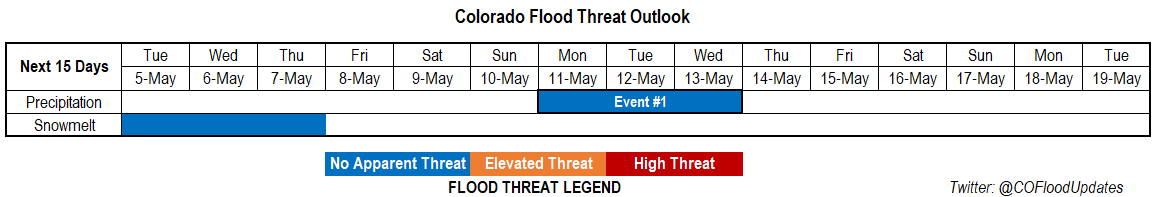
Valid Dates: 5/5 – 5/19
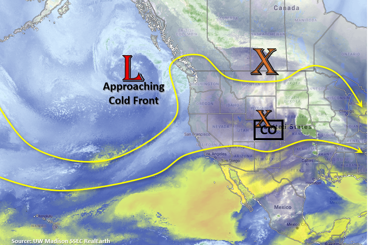
Not a whole lot happening for this season’s first FTO. With the growing ridge over Colorado expect temperatures to increase 2 to 4F each day through Thursday. By late Thursday, a cold front starts to drop south as some vorticity breaks off the low in the visible satellite imagery below. Not expecting a lot of storms to accompany the front at this time. The cold front will knock down high temperatures on Friday and some weak afternoon storms may be possible over the mountains in the afternoon. Over the weekend, expecting temperatures to warm back up as flow aloft turns from the northwest to westerly. A few afternoon storms will be possible over the Front Range, Central and Southeast Mountains as moisture slightly increases, although coverage is expected to be spotty. Sometime between next Monday and Wednesday, flow aloft will turn more southwesterly as another shortwave approaches the state for Event #1. This won’t be long lived, but it should bring some much need rainfall to western and southwestern Colorado. April around those parts was the driest on record, and over the last 3 months, the San Luis Valley has also been experiencing increasing drought conditions.
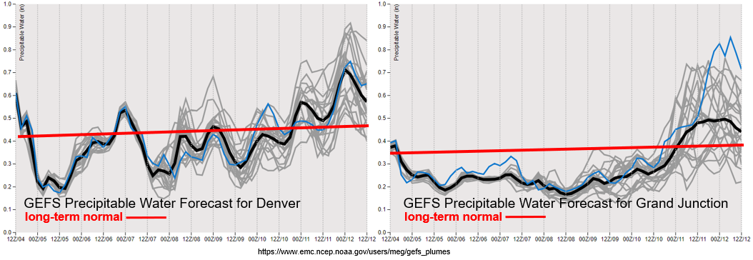
Below are the GEFS precipitable water plumes for Denver (left) and Grand Junction (right). As mentioned above, you can start to see an increase in moisture going into Monday of next week. Quite a bit of variability (spread between the gray lines) for Grand Junction, so tune back into the FTO on Thursday for the latest. Additionally, with low PW values and increasing winds on Wednesday and Thursday, there could be elevated fire danger. Be sure to keep up with the latest Red Flag Warnings by checking in with your local NWS office.
Winter Recap
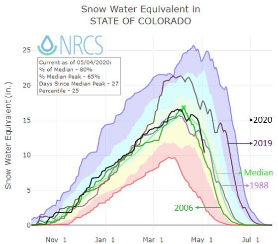
With a warm couple of months in March and April, the snowpack has already started to melt quite a bit for early May. You can see the statewide SWE for Colorado in black below and its steep downward trend since late April. Overall, not a bad snow year as it was very close to the 1981-2010 median value. Of course, parts of the southwest were drier than the Northern and Central Mountains. It looks like the melt out will occur sometime between late May and early June if the downward trend continues to look like 2006. Currently, there are some elevated flows over northern Colorado, which had the most snowfall and spring precipitation this year. Including a couple events over the last couple of days. Elevated flows are forecast along Elkhead Creek and Slater Fork Creek for the next couple of days. Not expecting them to go above bankfull conditions at this time, but levels will remain elevated and there may be some nuisance lowland flooding. The Illinois River near Rand, CO beat it’s record height of 2.6 feet (currently at 2.69 feet).
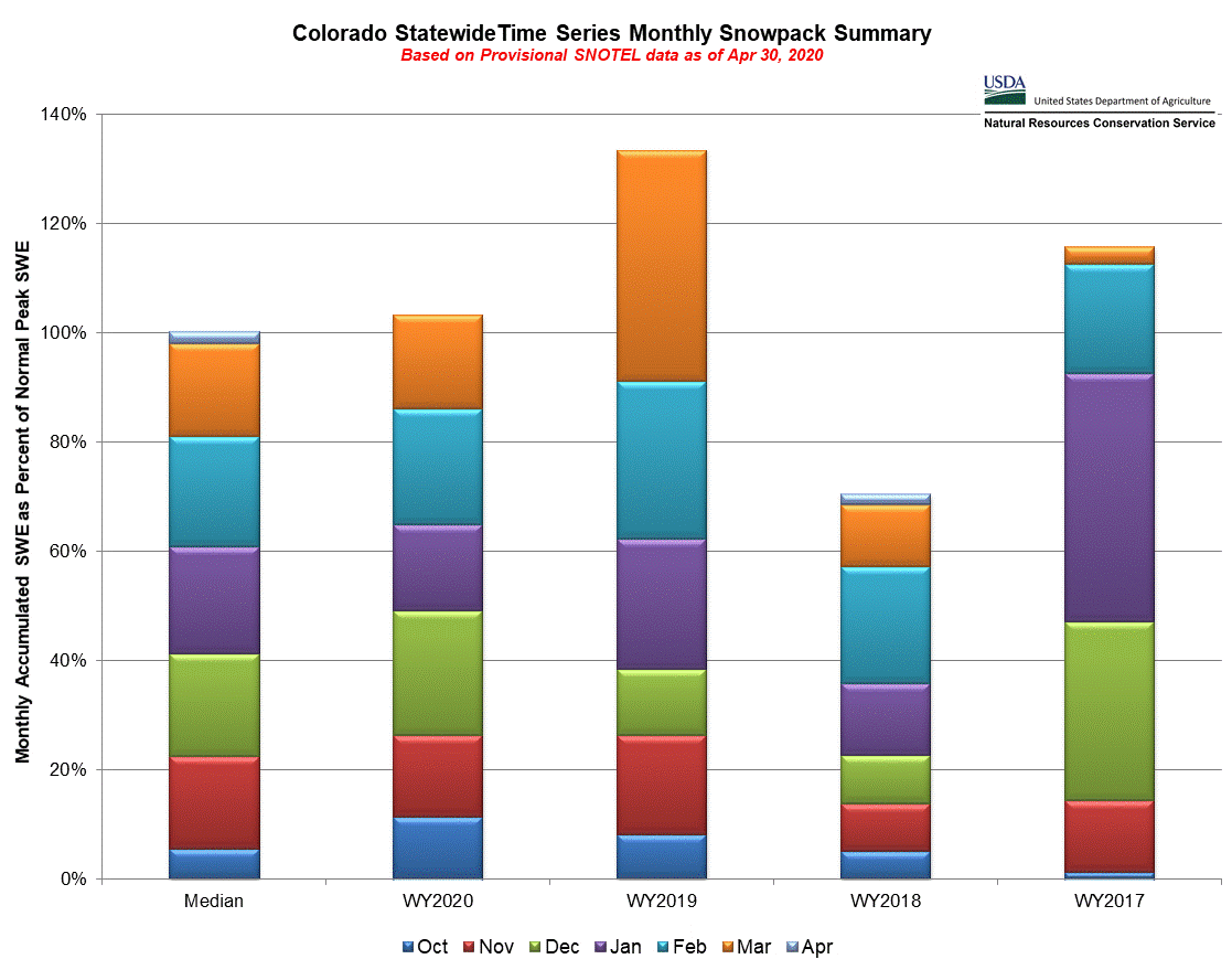
This second image breaks up the snowpack by month. If you remember last season, we had some big March storms that really pushed the SWE past 100% of normal. Not quite the story this year with December being the snowiest month. Those early season October storms can also be seen for WY2020. As mentioned above, overall we are looking at a good spring runoff with reservoirs mostly filled up. Southwest Colorado reservoirs are still a bit lower than the rest, but they are still at least above 70% of capacity.
Event #1: Monday (5/11) – Wednesday (5/13)
No Apparent Threat as moisture increases with southwest flow and a shortwave pass over the state.
Still quite a bit of change can happen over this next week, but it looks like a good wetting rainfall for the state is coming our way. This very needed rainfall for the western slope and southern Colorado, and it will hopefully help the increasing drought conditions. Reminder, these areas have been very dry over the last month or more. Still quite a bit of uncertainty, but the higher elevations of the southern mountains and adjacent eastern plains should receive the highest totals. More details on Thursday as this next system continues to develop.