Issue Date: Thursday, May 7th, 2020
Issue Time: 2:20PM MDT
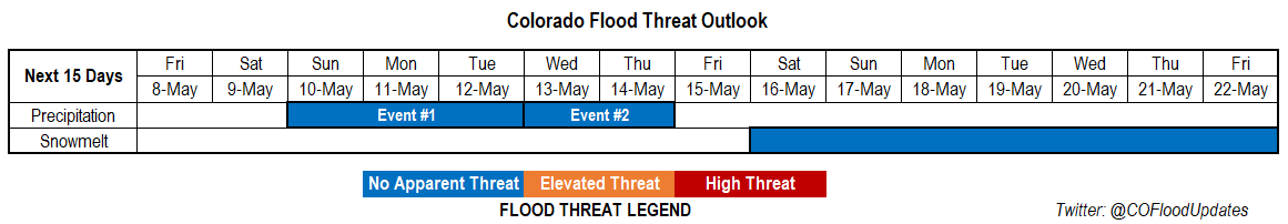
Valid Dates: 5/8 – 5/22
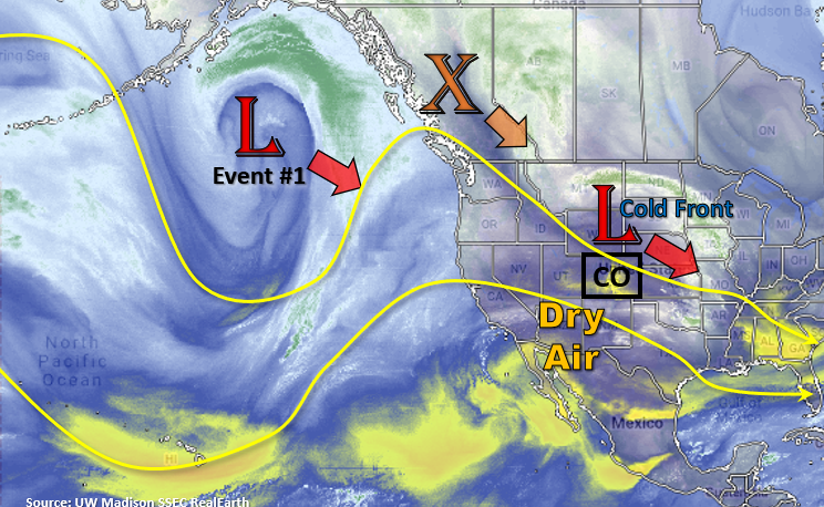
Taking a look at the water vapor imagery below from UW Madison, you can see the current low pressure system that is producing today’s elevated and critical fire weather. Behind the system, a strong cold front will drop south, which will help produce cooler temperatures on Friday. Flow over the weekend remains northwesterly, and another vorticity maximum drops south into our area. Once again there is not a lot of moisture, so it will just help to cool the high temperatures to more normal values (mid to upper 60Fs for the lower elevations).
By early next week the Low over the Gulf of Alaska starts to move southeast. This will push the ridge axis west and place it in a favorable pattern to pull moisture northward from the Gulf of California and Gulf of Mexico. Event #1 will begin on Sunday over the mountains with increasing coverage of showers into Monday. Moisture may stick around over the eastern plains on Tuesday, thus the threat continues. Event #2 quickly follows Event #1 as flow turns more southwesterly and a weak disturbance is pulled through the state. Storms should be confined to eastern Colorado favoring the Front Range, Urban Corridor, Northeast Plains and Palmer Ridge if there is enough moisture available. At this time, there is No Apparent threat for either event. As far as snowmelt, should start to see an increase in flows starting next week as warmer temperatures take hold. There is No Apparent threat for now, just wanted to highlight there may be some nuisance low-land flooding in a week or two.
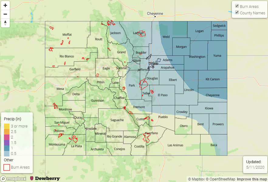
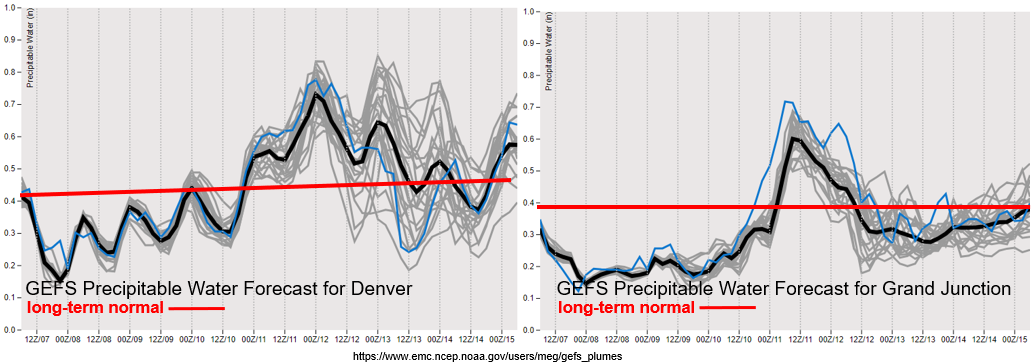
Quite the change in the GEFS precipitable water plumes starting on Sunday both east and west of the Continental Divide. Values will be well above normal with moisture sticking around over eastern Colorado after Tuesday. Depending on the timing of the system, some convection over western Colorado on Monday may be possible. The dry soils should have no trouble soaking up the moderate amounts of precipitation, but we’ll watch out for potential stronger storms that may track over the Lake Christine burn area in the daily FTB. So be sure to tune in!
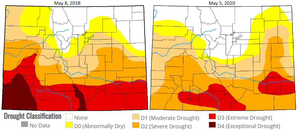
Just wanted to take a quick moment to look at the current drought situation. The drought map on the right is from Tuesday and the one on the left is from the same time in 2018. So, while we’re not looking at quite as dry of a start to spring, there are still some areas of concern. One of them is the San Luis Valley area and eastern San Juan Mountains. It has been incredibly dry over this area, and the last 2 months have been the driest on record. That dryness has carried over to the Southeast Plains which went from D1 (abnormally dry) to D3 (extreme drought) over the same period. Hopefully next week’s rain (Event #1) can start to help the drought situation out over these regions. At this time, we are looking at higher fire danger this summer, so please keep this in mind with your daily activities. For a rundown of fire terminology and Red Flag Warning criteria, head over to today’s SPM.
Event #1: Sunday (5/10) – Tuesday (5/12)
No Apparent Threat as moisture increases from the south with the ridge axis over eastern Colorado.
Showers and thunderstorms look to return to the majority of the state during this event. Expecting an increase in thunderstorm activity over the mountains on Sunday. From Sunday night into Monday morning, coverage of storms is expected to increase from west to east. There is a chance for some embedded convection on Monday in western Colorado and the mountains, so the FTB will watch this closely. Not thinking there will be much of an overall flood threat, but rain rate thresholds may be high enough to cause flooding problems over the Lake Christine burn area. Very much looking forward to this precipitation with most of it being a nice stratiform rainfall. Expect some snow over the highest elevations on Sunday night just due to the colder temperatures. On Tuesday, there may be a chance for some severe weather over the far eastern plains, but it’s a little too early to hammer out any of the details. This is the only reason the flood threat was extended an extra day.
Event #2: Wednesday (5/12) – Thursday (5/14)
No Apparent Threat as a vorticity max pulls through the state with elevated moisture over northern and eastern Colorado.
Quickly occurring after Event #1 is Event #2. Flow aloft will become southeasterly for this event and some mid-level energy looks to move through the state. This will likely cause scattered thunderstorms over the higher terrains (northern Mountains and Front Range). Activity will likely spread into the eastern plains on both days as there will likely be surface lows forming over eastern Colorado. It’s a bit too early to know exactly what moisture will look like, but the slight downward trend in the GEFS plumes indicates that (at this time) there will be No Apparent flood threat for the storms.