Issue Date: Monday, September 30th, 2019
Issue Time: 2:10PM MDT
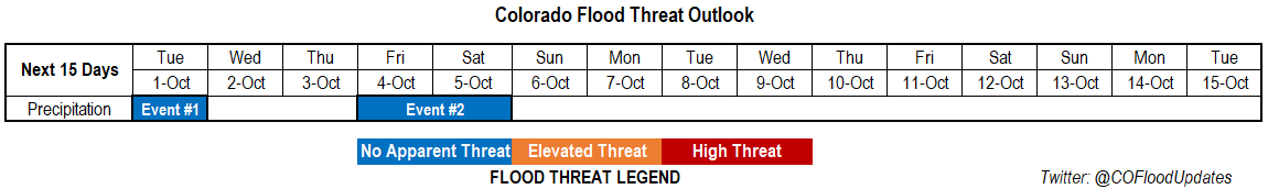
Valid Dates: 10/1– 10/15
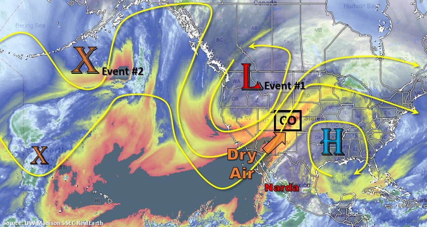
Fire danger continues to remain high over the state as the low deepens over the Pacific Northwest and mixes high winds down to the surface. The southwest flow will continue to pull in a very dry air mass over the majority of the state from the southwest over the next couple of days. This can be seen in the water vapor imagery below with the shades of yellow and orange. The jet remains overhead through Wednesday before the low passes to our north and a ridge begins to slide in from the west. Thus, pockets of Elevated and Critical Fire weather are forecast through this period. Overnight cold fronts on Monday and Tuesday will help keep temperatures more seasonable to start this week and could produce some light rainfall for the northeast corner of the state each night. Moisture return from the fronts and cooler temperatures may keep fire danger lower over these locations.
On Tuesday, enhanced convergence along a stalled out front may help produce some moderate afternoon rainfall over the eastern border in the vicinity of Cheyenne and Kiowa County. Meanwhile, over the southeast US, a subtropical high is pulling in higher PW values on its west side. Some of this moist air mass may make its way northward by early Tuesday morning, which could produce rainfall over eastern Baca and Prowers Counties. Should the moisture surge continue northward tomorrow morning over this area, there is a possibility for some heavy rainfall to occur from the morning into the early afternoon. Rain rates should be gradual enough (lower instability) and over a limited area that major flooding should be avoided. Thus, the No Apparent Threat for Event #1. Dry air and subsidence follow the trough’s passage, so it should be quiet on the rain front through the end of this week with high temperatures increasing Wednesday and Thursday.
The next low (Event #2) swings rather quickly from west to east over Canada at the end of this week. There doesn’t look to be a lot of moisture with this event, and with the main axis to our north there is No Apparent Flood Threat at this time. There will likely be a small increase in moisture as the system approaches, so forecast scattered showers (and snow at the highest elevations) to return to the northern high terrains on Friday and Saturday. If the system is on the drier end, Critical Fire weather could be possible as the surface gradient tightens. An overnight cold front will drop in behind the low Friday night into Saturday, so fall-like weather is anticipated to start this weekend. It should be a great weekend to get out and enjoy the changing leaves!
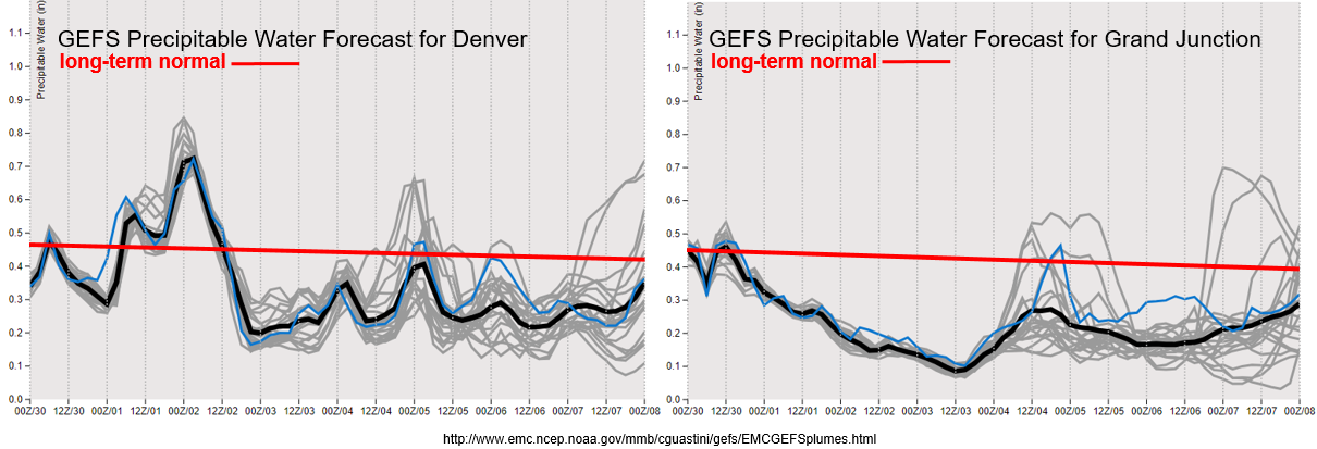
PW has already started to drop off over western Colorado behind the temporary, post-frontal moisture increase. It will remain well below average through next weekend, and with the jet overhead, fire weather (critical or elevated) is likely tomorrow and Wednesday. Be sure to tune into to your local NWS office for the latest. Over eastern Colorado, there is a slight moisture return behind the frontal passages on Monday and Tuesday evening. With PW still below 0.8 inches, light rainfall and cloud cover will likely be all the atmosphere can muster. PW drops off drastically after Tuesday night and remains well below average the rest of the week. Thus, there will likely be a brief increase in fire danger over eastern Colorado as well. Still quite a lot of variability for moisture return during Event #2, but even if PW can reach 0.7 inches (east), the system will likely only produce scattered showers over the high terrains.
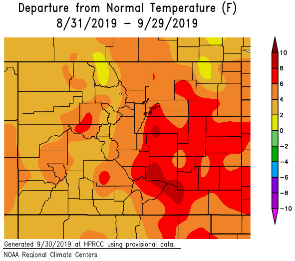
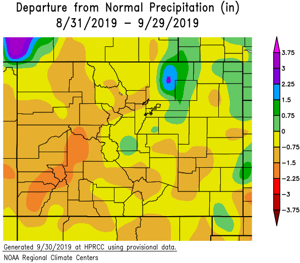
Below are the temperature and precipitation statistics for September. Not surprisingly, it was above to much above average in regards to temperature for the month. The southern Urban Corridor (Colorado Springs to Pueblo) saw temperatures as much as 8-10°F above normal! Precipitation over this same area was 0.75 to 1.5 inches below normal, which means they had only about half of their normal rainfall for September. It was the driest over western Colorado where some areas only were 1.5 to 2.25 inches below normal. Weld County received above average precipitation as well as isolate locations over the eastern border. Climatology for these regions in September is about 1 to 1.5 inches.
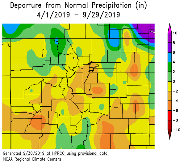
Since April 1st (bottom panel), most of Colorado is at/slightly above or below normal precipitation. There are a couple pockets over the northern border that did really well for the season, but overall above average temperatures and below average rainfall (after June) really started to dry things out. The San Juan Mountains, Raton Ridge and portions of the Palmer Ridge/Northeast Plains are 4 to 6 inches below normal for this period. Thus, the D1 drought has returned to the southwest corner (including the western San Juan Mountains) as well as to the Central Mountains near the Continental Divide. All of western Colorado and nearly all of the mountains are in the D0 drought stage. This lack of rainfall is also seen in the decrease of streamflow, which can be found here: USGS daily streamflow conditions.
Event #1: Tuesday (10/1)
No Apparent Threat as the low drops a cold front south and a minor PW surge occurs over the southeast corner of the state.
Looking at much cooler temperatures north of the cold front on Tuesday. This will return some low level moisture as well, so some light showers, fog and cloud cover will be possible over northeast Colorado on Tuesday morning, which includes the northern Front Range. Additional, heavier rainfall will be possible over the Southeast Plains (CO/KS border) tomorrow. The first area to focus on will be the southeast corner as higher PW pushes in the area from morning to early afternoon. The second area to watch, during the afternoon, will be along the stalled out front. Heaviest rainfall is forecast here if the frontal rainfall can push far enough back west (not capped). A couple severe storms may be possible in this area with the main threats being gusty outflow winds and severe hail. South of the front, temperatures will be in the 80°Fs, so looking at quite the temperature gradient over eastern Colorado. Additional overnight rainfall is possible over northeast Colorado as another front pushes south on Tuesday evening. There is No Apparent Flood Threat for any of the rainfall during this period.

Event #2: Friday (10/4) – Saturday (10/5)
No Apparent Threat as another trough pushes from west to east to the north.
Confidence for moisture return (magnitude) is low for this event, but ensemble guidance is showing enough moisture return for at least scattered storms over the northern mountains on Friday. The tropical moisture plume (from the last FTO) looks to remain south and east for this event, with higher confidence in that statement than the last FTO. Thus, there is No Apparent Flood Threat issued. Some scattered storms may possible with residual moisture over the mountains on Saturday, but cooler temperatures will likely keep rain rates low. There is equal chance westerly flow aloft will scour out the remaining moisture and return the fire threat. Due to a strong cold front passage Friday night, a dusting of snow at the highest elevations cannot be rule out. A map is not drawn below due to totals from the system remaining under 0.5 inches.