FTO 08-31-2020: Dry Weather with On & Off Warm Temperatures Forecast

Issue Date: Monday, August 31st, 2020
Issue Time: 1:40PM MDT
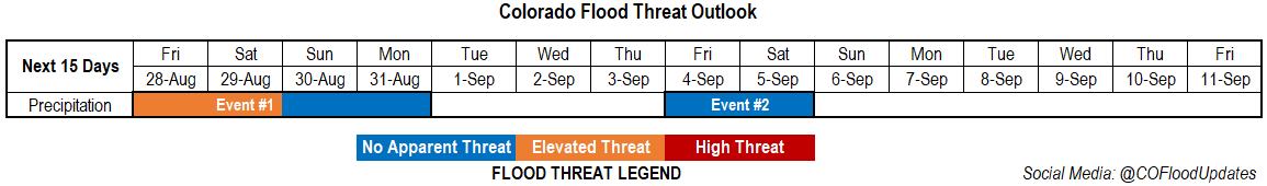
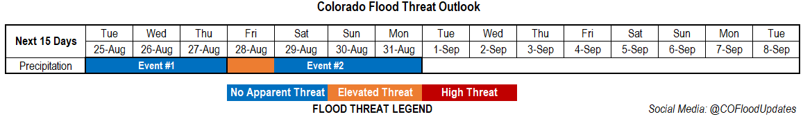
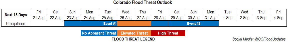
Valid Dates: 9/1– 9/15

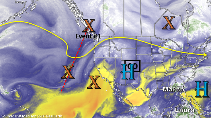
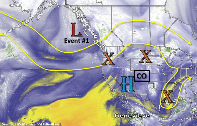
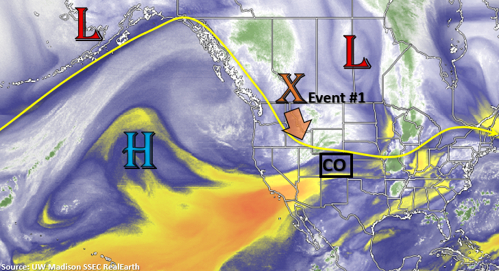
An upper shortwave trough will continue to plunge south and cut itself off from the main flow by tomorrow (Event #1). This feature will bring some cooler temperatures to western Colorado as well as some overnight rainfall for the mountains on Monday. By Tuesday morning, the rainfall and upper level energy will be over the southern mountains. As the rain pushes east into the Southeast Plains and the Raton Ridge by mid-morning, some cloud cover and light rainfall should be expected. Tomorrow afternoon, outside of a chance for rainfall over the Southeast Mountains and southern San Juan Mountains, it should be dry and cool across the state. There is No Apparent threat for this event, although rain rates will be watched closely as storms could form over the recent burn areas in the Southeast Mountains. Rain rates will be dependent on how much instability can form after the shortwave moves through.

Dry northwest flow will fill in behind the shortwave trough as the High builds into NV/CA. As the subtropical High strengths throughout the week, dry and warm conditions are forecast. Occasional weak fronts will likely move through the northwest flow, which could briefly cool the afternoon temperatures over eastern Colorado. It looks to heat up and stay warm out west until a strong front moves through at the end of this weekend on the east side of an amplified ridge pattern. There’s low confidence in Event #2, but if it does occur, it will likely be short-lived.

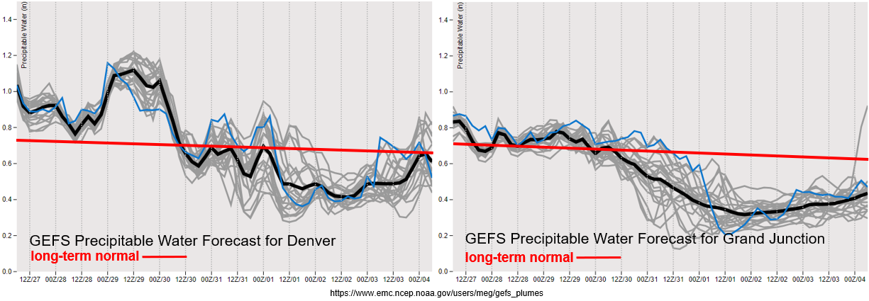
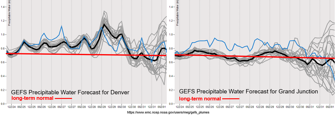
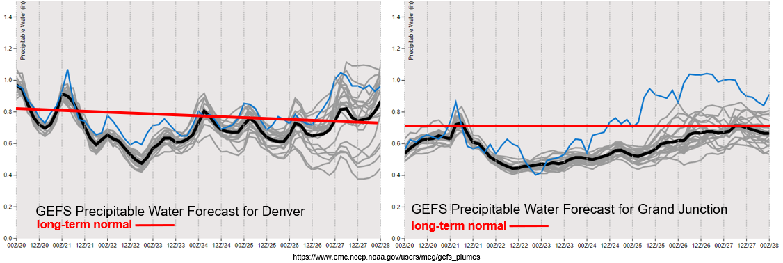
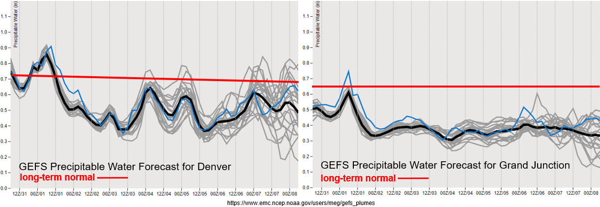
PW values plummet after the shortwave moves through, and both areas east and west of the Continental Divide are at below normal values by tomorrow afternoon. PW stays well below normal over western Colorado through the end of this week, so there will be little to no chance for rainfall. Thankfully under the ridging pattern, surface winds should stay milder. However, warming temperatures and low relative humidity will keep fire danger elevated with the overly dry fuels.

There’s a slight increase in PW over Denver mid-week, which is likely from a weak front moving through the area. This may return scattered, weak showers to the mountains, but with a dry boundary layer, little to no rainfall is forecast at this time. The next increase in PW (Event #2) at least has the potential to return higher PW values to the plains, which could increase the chances for some moderate rainfall. This would only occur if the system has decent low-level moisture return and the front drops through the state at the right time of day. There’s low confidence in both of these forecast elements this far out.

Event #1: Tuesday (9/1)

No Apparent threat as isolated storms return to the southern mountains behind the passing trough.

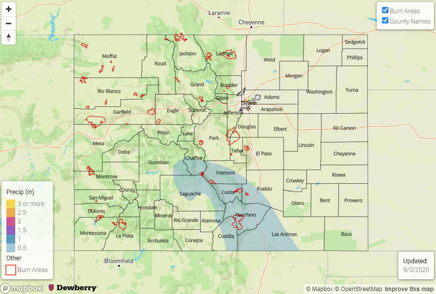
Overall, it will finally be cool statewide with mostly rain free conditions forecast for Tuesday. Rainfall chances tomorrow should stick to the southern mountains and favor the Southeast Mountains. At this time, mid-level energy doesn’t look widespread and unsure how much instability will be able to form by the afternoon. Therefore, storms should have some smaller storms cores and less instability to work with, which will limit their heavy rainfall potential. If a storm forms directly over a burn area (Spring Creek, Decker), there’s an increased risk for flash flooding with the slow storm movement. These burn areas will be closely monitored in tomorrow’s FTB, but chances for exceeding thresholds with the pop-like convection is on the lower end. So, No Apparent threat has been issued.

Event #2: Sunday – Monday (9/69/7)

No Apparent threat as a stronger shortwave moves southward on the east side of a ridging pattern.

Since there is such low confidence in model members this far out, still choosing not to draw a map. For the most part, the rainfall chances will be highest over the eastern plains where some moderate rainfall could develop. If the front can drop through at peak heating, there may be a chance for some more widespread thunderstorms. Unsure how far back west the low-level moisture will hang on, but scattered pops over the eastern mountains seem reasonable. Mostly just wanted to point out when the next cool down will occur as temperatures will be on the rise under the ridge, especially over western Colorado. At this time, there is No Apparent flood threat.

FTO 08-27-2020: Cool and Dry Conditions around the Corner after an Elevated Flood Threat

Issue Date: Thursday, August 27th, 2020
Issue Time: 2:50PM MDT
Valid Dates: 8/28– 9/11

Early tomorrow morning, a cold front quickly dips south as a trough passes to our north. Expecting some decent moisture return with the boundary over eastern Colorado along with gusty northerly winds over the plains as it passes overhead. This should reduce high temperatures over the eastern portion of the state with little to no change in high temperatures expected over western Colorado. On Sunday night, the Low marked in the image below will drop a very strong cold front over the state, which will finally break down the stubborn subtropical High and give us our first taste of fall. Perfect timing for the start of meteorological fall on September 1st. From Monday into Tuesday, a quieter weather pattern will take over with little to no rain forecast. It looks like another fall-like front and rainfall will come through at the end of next week (Event #2), but confidence this far out is much lower.

Over Denver, PW values surge to over an inch tomorrow behind the front and are forecast to remain elevated through Saturday. This will cause an Elevated flood threat to be issued with a focus on the eastern mountains and plains from about the Palmer Ridge and south. That will also mean an increased flood threat for the recent burn areas over the Southeast Mountains and possibly others further north (Front Range), so stay tuned for the latest in the FTB. There’s a large drop off in moisture after Saturday, but some stratiform rain will be possible with the incoming system at the end of the weekend over the mountains.

Over western Colorado, PW remains around average until Sunday. That means some scattered storms should be expected over the highest peaks similar to today. Highest totals and more coverage of storms are anticipated along and near the Continental Divide and over the southern San Juan Mountains. Statewide, it should really dry out after Monday with little to no rainfall forecast next week. Hoping the jet will stay further north, as the models currently indicate, to keep the fire danger lower with the return of hot and dry conditions by Wednesday.

I have included the GEFS 2-meter temperature at Denver (bottom image), so you can see just how much temperatures decrease behind the strong cold front. A little uncertainty (red oval) about how quickly the high temperatures will rebound, but the cooler temperatures are relatively short-lived. Expecting highs to drop over western Colorado as well with this front, so finally everyone gets a break from the heat.

DEN 2-meter Temps (below)

Just wanted to do a quick drought update since a new map came out on Tuesday. Colorado now has a large area under D3 (Extreme Drought) conditions or ~36% of the state. There’s a small area of Kiowa County experiencing D4 (Exceptional Drought) conditions. Hoping for some beneficial rainfall over the Raton Ride/Southeast Plains tomorrow night as an MCS may potentially set up. The dryness of August puts most of the mountains and western Colorado below 25% of normal precipitation for the month. The majority of the state is below 50% of normal precipitation for August, and the southern Front Range/western Palmer Ridge is greater than 2.25 inches below normal over the last 30 days. Paired with temperatures being 2 to 6F above normal, the worsening drought conditions are not surprising. For comparison, on the left is the drought map at the start of the FTB season.

Event #1: FridayMonday (8/28 – 8/31)

Elevated/No Apparent threat as a cold front returns moisture to eastern Colorado and is expected to produce some heavy rainfall south.

The northerly winds behind the front will turn more easterly tomorrow afternoon, and with an increase in moisture, some heavier rain is anticipated. More scattered storms are forecast over the western high terrains for the next couple of days. An area of concern for this event is rainfall over recent burn areas, which is especially true over the Southeast Mountains. Be sure to tune into the FTB for the latest on the flood threat each day. As storms move off the mountains, expect an increase in intensity as well. So, some weak severe thunderstorms will also be possible tomorrow afternoon over the adjacent plains, which includes the I-25 corridor. Right now, the largest threat for flooding looks to be over the Southeast Mountains and Raton Ridge where the front seems to stall out. As the storms move east, an MCS will likely set up and rain could linger overnight. This would be great for the Raton Ridge and Southeast Plains, as long as there isn’t too much rainfall at once.

Event #2: Friday – Monday (8/28 – 8/31)

No Apparent threat as the next system pushes south and returns some moisture and cooler temperatures.

I didn’t draw a map for this event as there is low confidence in this forecast. I just wanted to mention when precipitation might return to the forecast as well as some cooler temperatures. It’ll be a warm and dry stretch after Monday, but hopefully it won’t be long-lived as northwest flow aloft could drop another system south by the end of next week.

FTO 08-24-2020: Afternoon Storms for the Mountains with an Elevated Flood Threat to End the Work Week

Issue Date: Monday, August 24th, 2020
Issue Time: 2:30PM MDT
Valid Dates: 8/25– 9/8

It has been hot the last few days, and the heat is expected to continue until a cold front drops through the state at the end of this week. There’s a positively tilted trough to our west (red dotted line) that will start to move inland today. This will help weaken the ridge and push the axis in a more favorable position to pull more subtropical moisture northward. With daily rounds of rain forecast the next couple of days due to increased mid and upper level moisture, expect the boundary layer to moisten, which will allow for higher totals to reach the ground each afternoon over the mountains.

Lee troughing over the plains is also forecast, but it looks like it will be pretty well capped unless there’s a strong, well-timed shortwave that moves through. Best chance for storms over this area will be at the end of the week. Late Thursday into Friday, a cold front drops south, which looks to return some higher surface moisture. With more westerly steering flow aloft, storms have the potential to survive over the plains as they move off the mountains. An Elevated flood threat has been issued. From Saturday into Monday, expect storm coverage to decrease each afternoon as a strong trough dips south and starts to push a dry air mass into the state.

Looking at near and slightly above average PW from tomorrow into Friday morning. This will help produce daily rounds of rainfall over the mountains. Gusty outflow winds and local, dry lightning will still be a concern before more wetting rainfall occurs Wednesday over western Colorado. On Friday, there’s a big increase in PW over eastern Colorado associated with that cold front. Extra sub-tropical moisture should also be over the Great Plains, so some extra moisture could be drawn into the state Friday and Saturday with south/southeasterly surface flow. Another reason for the Elevated flood threat. Lots of disagreement between model members by next week, but if the PW values follow the low-end members, there could be an increase in fire weather conditions.

Event #1: Tuesday – Thursday (8/25 – 8/27)

No Apparent threat as mid and upper level moisture move over the state and return storms to the mountains each afternoon.

No Apparent threat for Event #1 as mid and upper level moisture increases across the state with some extra mid-level energy moving through the flow. Storms for the most part will be high-based, so not thinking there’s a large flood threat at this time. Increasing wetting rains are anticipated on Wednesday and Thursday, which will be good for the ongoing fires over the mountains. Going to add the new burn areas to the threat map tomorrow, so we can keep an eye on those. The Grizzly Creek fire will be monitored the most closely the rest of the season as Glenwood Canyon is already dangerous with its steep, rocky slopes.

Event #2: Friday – Monday (8/28 – 8/31)

Elevated/No Apparent threat as a front helps return some low-level moisture to eastern Colorado.

This shouldn’t be a prolonged Elevated event, but with increased moisture and slower steering winds under the ridge, storms may be able to produce some flooding on Friday. After a likely break in widespread rainfall over the mountains on Thursday, precipitation chances will increase over a larger area again. The Southeast Mountain burn areas will be monitored closely as well as some of the newer burn areas. Without much upper air support, the threat for severe weather is on the lower end over the plains, but be sure to check back on Thursday as details will likely change for this event.

FTO 08-20-2020: A Couple Days of Drying Before Storms Return to the Forecast

Issue Date: Thursday, August 20th, 2020
Issue Time: 2:45PM MDT
Valid Dates: 8/21– 9/4

The stubborn ridging pattern will hang on and persist through this weekend even with a strong incoming trough from the Pacific Northwest. With the High to our west, a drier air mass will be over the state to start this weekend, so is should stay mostly rain-free tomorrow and Saturday with some isolated convection possible over the southern mountains. By Sunday, the High moves into the 4-corners region and Genevieve moves northward. This is expected to bring some mid-level energy and slightly more moisture into the state for scattered afternoon storms over eastern mountains and adjacent plains. This typical afternoon rainfall pattern should continue into next week with the chances for rain increasing over western Colorado after Monday.

By mid-week, the weather gets a little more interesting as a tropical disturbance from the Gulf of Mexico could move into the High Plains and a cold front drops south. There’s a lot of divergence in model runs, but thought it was worth mentioning and why an Elevated flood threat has been issued. It’s likely that an Elevated threat will just be needed on one of those two days. Event #2 begins on Saturday as residual moisture is recycled and will help produce scattered afternoon storms. The amount of residual moisture (related to the coverage of storms) will be directly tied to the tropical disturbance’s path. So, confidence in the forecast is pretty low this far out.

We’ve finally come to that time of year where climatological (average) PW values start to decline again. It doesn’t mean that some late season PW surges aren’t possible, but the window for the monsoon season rainfall is closing. Overall, not an impressive year for the monsoon rainfall as indicated by the worsening and large area of the drought. Over Denver and eastern Colorado, the decrease in PW described above can be seen over the next couple of days before PW returns to a more seasonal value. By the end of the forecast period, you start to see the divergence (indicating uncertainty) between the different model runs associated with that tropical disturbance.

A similar pattern can be seen over western Colorado (right side). So, expecting storms (and rainfall) to increase in coverage after Monday. Until then, storms that develop over western CO with the help of passing shortwaves will produce more wind and dry lightning, which is not good with the ongoing fires and dry fuels. Really hoping the wetting rainfall in the GEFS forecast comes to be realized. The ECMWF is also showing an increase in the coverage of storms, but with less measurable rain, which is typical. It is encouraging to see an upward trend in more widespread showers from both models though.

Event #1: SundayThursday (8/23 – 8/27)

Elevated/No Apparent as leftover tropical disturbances start to make their way northward and help increase moisture.

No Apparent threat to start Event #1 as storms start to increase in coverage on Sunday. It isn’t until Tuesday or Wednesday before the chance for wetting rainfall returns to western Colorado. Until then, above average temperatures and dry conditions are expected to continue. Possibly a slight decrease in high temperatures starting on Saturday over the San Juan Mountains and Southwest Slope. Increasing, high temperatures should be expected over eastern Colorado this next week, so it will be a bit of a heat wave. Over the mountains, daily rounds of storms will be possible favoring the southern and eastern terrains. With more northerly steering flow, storms will likely stick closer to the mountains. Lee troughs may help set up some convergence boundaries over the plains, so additional storms could fire in these areas, but warm air aloft will most likely keep convection capped. As always, if storms do fire, they will likely have slightly higher rainfall totals and some severe storms could be possible, but those details can be found in the daily FTB as its hard to tell where the dryline will set up. Higher rainfall totals and greater coverage of storms is forecast by mid-week. This would be really welcomed for the mountains, but totals are bit hard to estimate this far out.

Event #2: Saturday – Monday (8/29 – 8/31)

No Apparent threat as residual moisture is recycled under the ridge.

Not too concerned about this event for now. Looks like recycled moisture trapped under the ridge will continue to help trigger afternoon storms over the mountains. Currently, it is looking like this event will favor the northern mountains with more dry conditions south. Again, what happens during this period will be strongly dependent on the tropical system that moves through (or doesn’t) later next week, so confidence is lower. A drying trend is hinted at in the models by the end of this event, hence the shortness of the event.