Issue Date: Thursday, August 20th, 2020
Issue Time: 2:45PM MDT
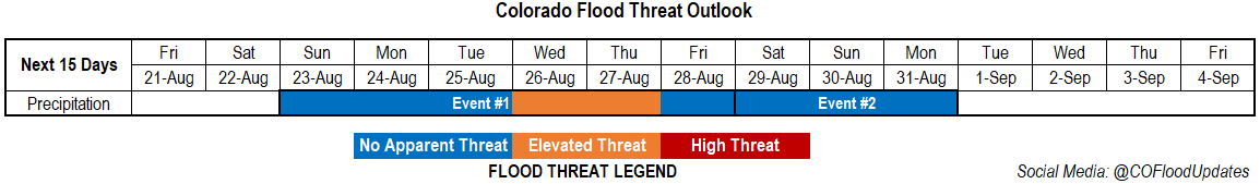
Valid Dates: 8/21– 9/4
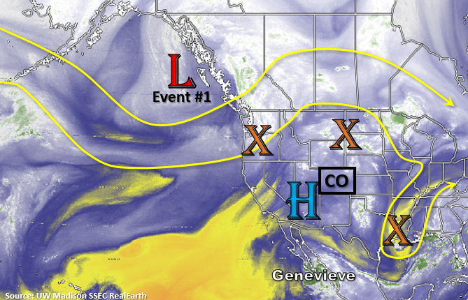
The stubborn ridging pattern will hang on and persist through this weekend even with a strong incoming trough from the Pacific Northwest. With the High to our west, a drier air mass will be over the state to start this weekend, so is should stay mostly rain-free tomorrow and Saturday with some isolated convection possible over the southern mountains. By Sunday, the High moves into the 4-corners region and Genevieve moves northward. This is expected to bring some mid-level energy and slightly more moisture into the state for scattered afternoon storms over eastern mountains and adjacent plains. This typical afternoon rainfall pattern should continue into next week with the chances for rain increasing over western Colorado after Monday.
By mid-week, the weather gets a little more interesting as a tropical disturbance from the Gulf of Mexico could move into the High Plains and a cold front drops south. There’s a lot of divergence in model runs, but thought it was worth mentioning and why an Elevated flood threat has been issued. It’s likely that an Elevated threat will just be needed on one of those two days. Event #2 begins on Saturday as residual moisture is recycled and will help produce scattered afternoon storms. The amount of residual moisture (related to the coverage of storms) will be directly tied to the tropical disturbance’s path. So, confidence in the forecast is pretty low this far out.
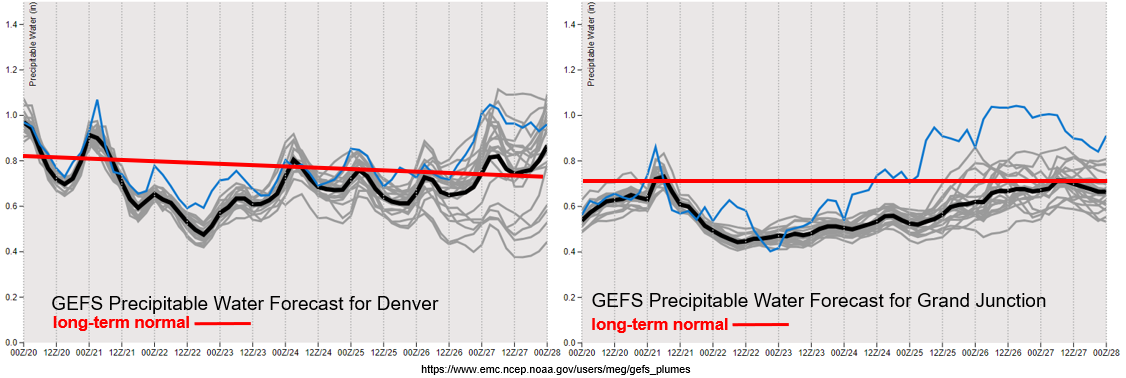
We’ve finally come to that time of year where climatological (average) PW values start to decline again. It doesn’t mean that some late season PW surges aren’t possible, but the window for the monsoon season rainfall is closing. Overall, not an impressive year for the monsoon rainfall as indicated by the worsening and large area of the drought. Over Denver and eastern Colorado, the decrease in PW described above can be seen over the next couple of days before PW returns to a more seasonal value. By the end of the forecast period, you start to see the divergence (indicating uncertainty) between the different model runs associated with that tropical disturbance.
A similar pattern can be seen over western Colorado (right side). So, expecting storms (and rainfall) to increase in coverage after Monday. Until then, storms that develop over western CO with the help of passing shortwaves will produce more wind and dry lightning, which is not good with the ongoing fires and dry fuels. Really hoping the wetting rainfall in the GEFS forecast comes to be realized. The ECMWF is also showing an increase in the coverage of storms, but with less measurable rain, which is typical. It is encouraging to see an upward trend in more widespread showers from both models though.
Event #1: Sunday – Thursday (8/23 – 8/27)
Elevated/No Apparent as leftover tropical disturbances start to make their way northward and help increase moisture.
No Apparent threat to start Event #1 as storms start to increase in coverage on Sunday. It isn’t until Tuesday or Wednesday before the chance for wetting rainfall returns to western Colorado. Until then, above average temperatures and dry conditions are expected to continue. Possibly a slight decrease in high temperatures starting on Saturday over the San Juan Mountains and Southwest Slope. Increasing, high temperatures should be expected over eastern Colorado this next week, so it will be a bit of a heat wave. Over the mountains, daily rounds of storms will be possible favoring the southern and eastern terrains. With more northerly steering flow, storms will likely stick closer to the mountains. Lee troughs may help set up some convergence boundaries over the plains, so additional storms could fire in these areas, but warm air aloft will most likely keep convection capped. As always, if storms do fire, they will likely have slightly higher rainfall totals and some severe storms could be possible, but those details can be found in the daily FTB as its hard to tell where the dryline will set up. Higher rainfall totals and greater coverage of storms is forecast by mid-week. This would be really welcomed for the mountains, but totals are bit hard to estimate this far out.
Event #2: Saturday – Monday (8/29 – 8/31)
No Apparent threat as residual moisture is recycled under the ridge.
Not too concerned about this event for now. Looks like recycled moisture trapped under the ridge will continue to help trigger afternoon storms over the mountains. Currently, it is looking like this event will favor the northern mountains with more dry conditions south. Again, what happens during this period will be strongly dependent on the tropical system that moves through (or doesn’t) later next week, so confidence is lower. A drying trend is hinted at in the models by the end of this event, hence the shortness of the event.