Issue Date: Thursday, August 27th, 2020
Issue Time: 2:50PM MDT
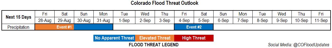
Valid Dates: 8/28– 9/11
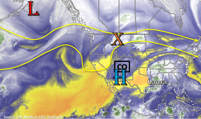
Early tomorrow morning, a cold front quickly dips south as a trough passes to our north. Expecting some decent moisture return with the boundary over eastern Colorado along with gusty northerly winds over the plains as it passes overhead. This should reduce high temperatures over the eastern portion of the state with little to no change in high temperatures expected over western Colorado. On Sunday night, the Low marked in the image below will drop a very strong cold front over the state, which will finally break down the stubborn subtropical High and give us our first taste of fall. Perfect timing for the start of meteorological fall on September 1st. From Monday into Tuesday, a quieter weather pattern will take over with little to no rain forecast. It looks like another fall-like front and rainfall will come through at the end of next week (Event #2), but confidence this far out is much lower.
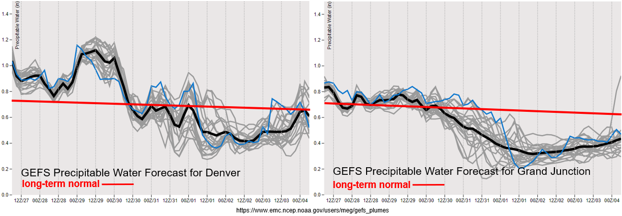
Over Denver, PW values surge to over an inch tomorrow behind the front and are forecast to remain elevated through Saturday. This will cause an Elevated flood threat to be issued with a focus on the eastern mountains and plains from about the Palmer Ridge and south. That will also mean an increased flood threat for the recent burn areas over the Southeast Mountains and possibly others further north (Front Range), so stay tuned for the latest in the FTB. There’s a large drop off in moisture after Saturday, but some stratiform rain will be possible with the incoming system at the end of the weekend over the mountains.
Over western Colorado, PW remains around average until Sunday. That means some scattered storms should be expected over the highest peaks similar to today. Highest totals and more coverage of storms are anticipated along and near the Continental Divide and over the southern San Juan Mountains. Statewide, it should really dry out after Monday with little to no rainfall forecast next week. Hoping the jet will stay further north, as the models currently indicate, to keep the fire danger lower with the return of hot and dry conditions by Wednesday.
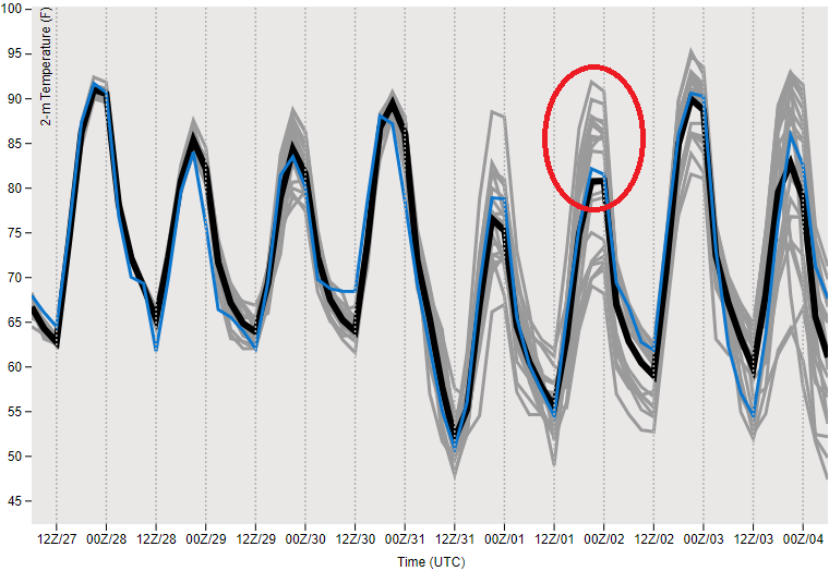
I have included the GEFS 2-meter temperature at Denver (bottom image), so you can see just how much temperatures decrease behind the strong cold front. A little uncertainty (red oval) about how quickly the high temperatures will rebound, but the cooler temperatures are relatively short-lived. Expecting highs to drop over western Colorado as well with this front, so finally everyone gets a break from the heat.
DEN 2-meter Temps (below)
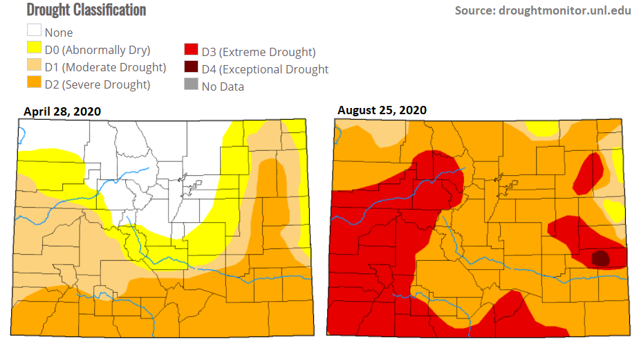
Just wanted to do a quick drought update since a new map came out on Tuesday. Colorado now has a large area under D3 (Extreme Drought) conditions or ~36% of the state. There’s a small area of Kiowa County experiencing D4 (Exceptional Drought) conditions. Hoping for some beneficial rainfall over the Raton Ride/Southeast Plains tomorrow night as an MCS may potentially set up. The dryness of August puts most of the mountains and western Colorado below 25% of normal precipitation for the month. The majority of the state is below 50% of normal precipitation for August, and the southern Front Range/western Palmer Ridge is greater than 2.25 inches below normal over the last 30 days. Paired with temperatures being 2 to 6F above normal, the worsening drought conditions are not surprising. For comparison, on the left is the drought map at the start of the FTB season.
Event #1: Friday – Monday (8/28 – 8/31)
Elevated/No Apparent threat as a cold front returns moisture to eastern Colorado and is expected to produce some heavy rainfall south.
The northerly winds behind the front will turn more easterly tomorrow afternoon, and with an increase in moisture, some heavier rain is anticipated. More scattered storms are forecast over the western high terrains for the next couple of days. An area of concern for this event is rainfall over recent burn areas, which is especially true over the Southeast Mountains. Be sure to tune into the FTB for the latest on the flood threat each day. As storms move off the mountains, expect an increase in intensity as well. So, some weak severe thunderstorms will also be possible tomorrow afternoon over the adjacent plains, which includes the I-25 corridor. Right now, the largest threat for flooding looks to be over the Southeast Mountains and Raton Ridge where the front seems to stall out. As the storms move east, an MCS will likely set up and rain could linger overnight. This would be great for the Raton Ridge and Southeast Plains, as long as there isn’t too much rainfall at once.
Event #2: Friday – Monday (8/28 – 8/31)
No Apparent threat as the next system pushes south and returns some moisture and cooler temperatures.
I didn’t draw a map for this event as there is low confidence in this forecast. I just wanted to mention when precipitation might return to the forecast as well as some cooler temperatures. It’ll be a warm and dry stretch after Monday, but hopefully it won’t be long-lived as northwest flow aloft could drop another system south by the end of next week.