FTO 09-28-2020: Prolonged Dry Period with Fall-like Temperatures

Issue Date: Monday, September 28th, 2020
Issue Time: 2:30PM MDT
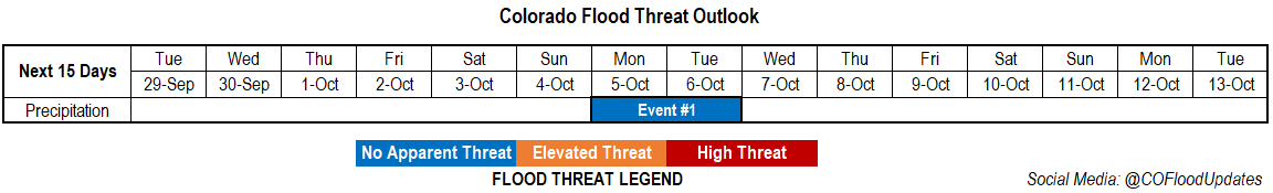
Valid Dates: 9/29 – 10/13

This is the last FTO for the 2020 season.

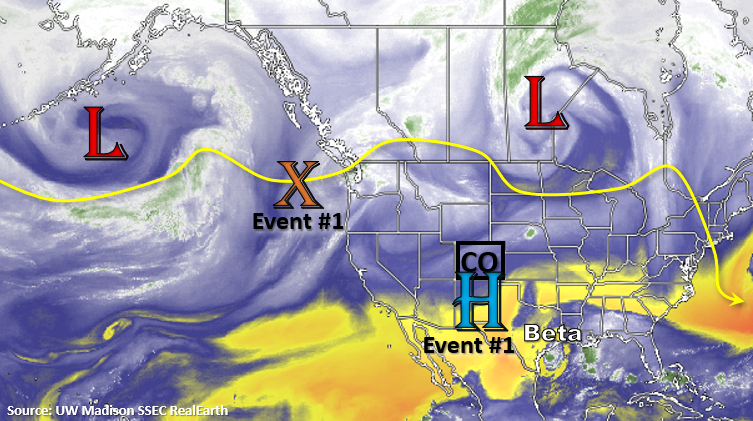
A prolonged dry period is the most on point way to end this flood season, due to the well below average precipitation that has occurred this year. An amplified ridge has set up over the western US, and this ridge will remain in place through early next week. This should keep a very dry air mass overhead. Northwesterly and northerly flow will push mid-level energy through the state on and off this week. Rather than increasing the chances for precipitation as they pass through, they will only help keep temperatures more seasonable. The first of the cold fronts drops through on Wednesday, and the next, over this weekend. Precipitation chances look like they may increase as the ridge begins to break down early next week (for a day). However, only very light precipitation will be possible along the northern Continental Divide, and there is an equal chance that no precipitation occurs. That means No Apparent threat is issued for the last event of the warm season.

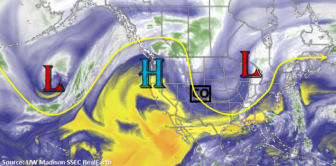
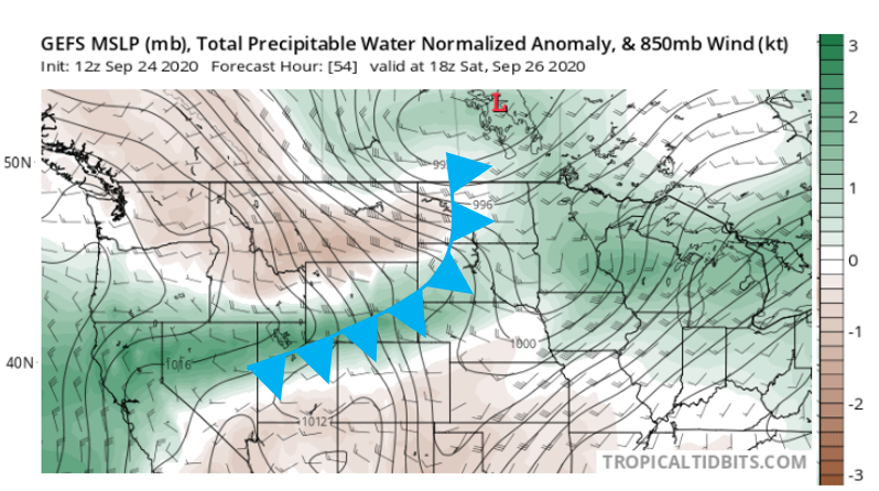
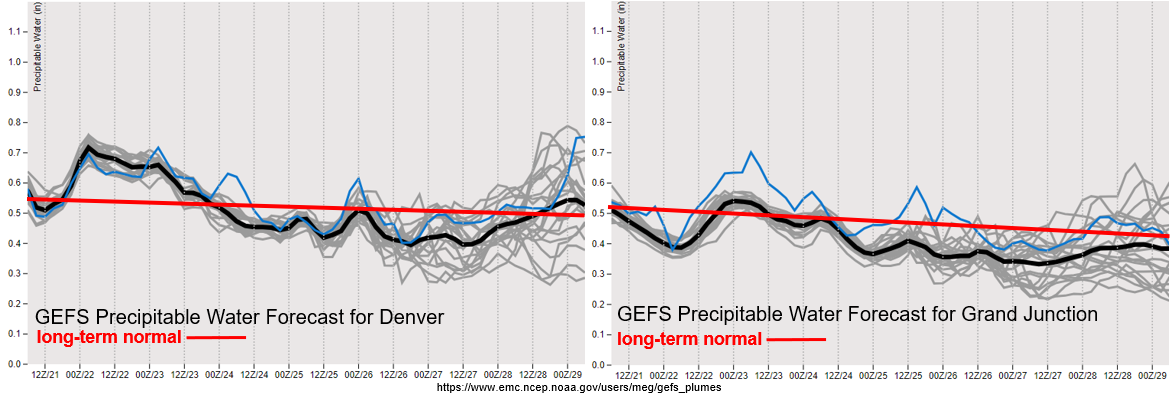
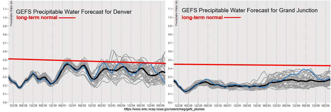
It will be very dry this next week over western Colorado, where PW (right) remains well below average. This is due to the dry air mass (yellow above) being pushed overhead with the eastward movement of the High. During the first part of the week, surface winds will start to die down; however, by this weekend, elevated fire conditions are possible as a jet streak potentially sets up over the state again.

To the east, PW remains below average with some variation in model solutions by the end of the week. Either way, PW values will likely remain near or below normal (0.50 inches), which will keep rainfall out of the forecast. Stronger surface winds may mix down the surface later this week as the jet meanders, so there is a possibility for elevated fire conditions. This will be tracked in the daily FTBs through Wednesday.

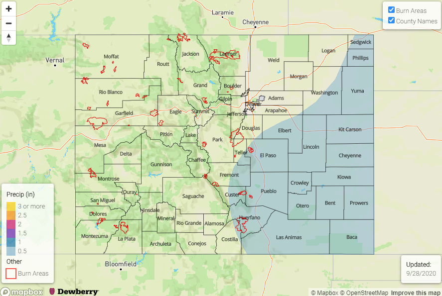
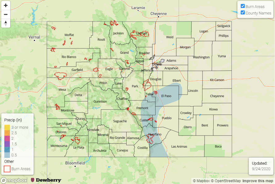
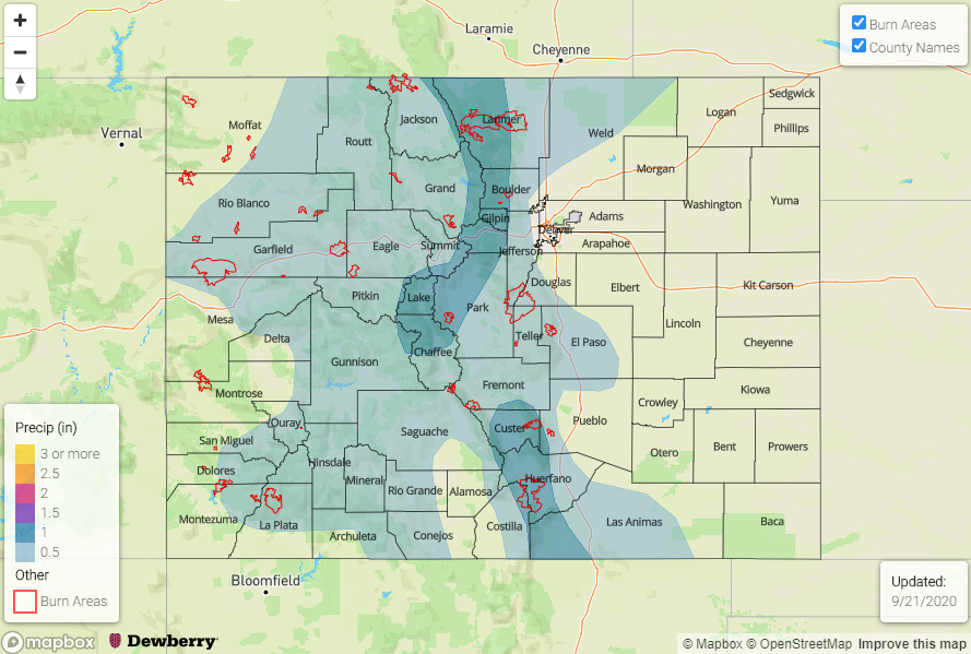
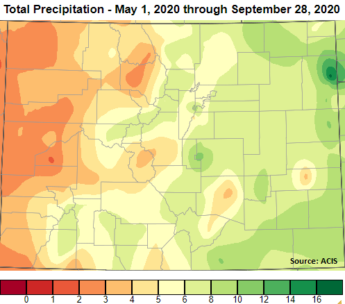
Below is a quick look at the total precipitation that has fallen from May 1st to present. Much of western Colorado has received less than 4 inches of precipitation for the period, but a couple large precipitation events over the San Juan Mountains boosted them into the 6 to 8 inch range. Also, distinctive in the map is the bulls-eye over Yuma County. Extreme rainfall fell over that area on July 23rd, and 6.3 inches was observed in Wray. So, this added a significant amount to the total precipitation for the period.

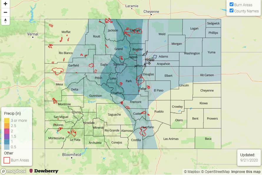
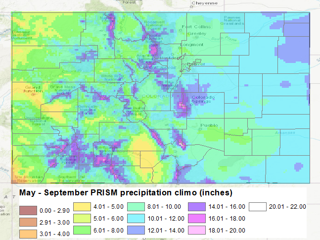
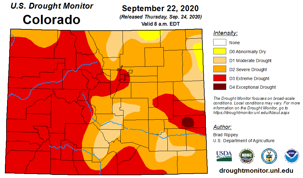
Below the first image (middle) is the average precipitation from May to September from PRISM (30-year normal). Overall, Colorado had well below average precipitation for the season. This led to an extended and worsening drought (bottom image). At the start of the season, only 11% of the state was in D3-D4 category. That percentage has increased 38%, and now half of the state has reached the D3-D4 category. At the beginning of the season, only 23% of the state was under no drought conditions, but that dropped to 0% by August after a quiet monsoon season. Not surprisingly, this led to a very active fire season and two new fires (Pine Gulch and Cameron Peak) broke into the top 3 largest Colorado wildfires of all time.
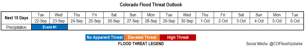
 

Event #1: MondayTuesday (10/510/6)

No Apparent flood threat as the ridge breaks down and returns minimal moisture to state.

No map has been drawn since it is highly likely precipitation totals will remain below 0.50 inches, and possibly, no precipitation at all will be recorded for this event. Best chance for some accumulation will be along and near the northern half of the Continental Divide. A rain/snow mix may be possible due to cooler temperatures at the highest elevations. As expected, there is No Apparent flood threat issued.

FTO 09-24-2020: Elevated/Critical Fire Weather Forecast with only a Small Window for Precipitation

Issue Date: Thursday, September 24th, 2020
Issue Time: 3PM MDT
Valid Dates: 9/25 – 10/9

The main weather concern over the next couple of days will be critical and elevated fire weather as the shortwave trough and associated jet move inland. This will help tighten the pressure gradient over the state and produce windy conditions on both Friday and Saturday. Elevated and critical fire weather are forecast within the pink dashed line below where high temperatures will help create low humidity as this relatively dry system approaches. A Red Flag Warning has already been issued for tomorrow over the northwest quadrant of the state.

Sometime on Saturday or early Sunday, a cold front will dig south as an omega block begins to set up over the western US. This is expected to help lower the fire danger and cool temperatures off for Sunday. This will also be the only window for precipitation chances to increase. Colorado should be on the east side of this feature next week, so increasing northwesterly flow aloft will help disturbances pass through the flow. Very dry air fills in behind the front, so no precipitation is forecast, just more seasonable temperatures.

Below is the GEFS PW anomaly (green is positive) and 850mb winds forecast for Saturday afternoon. There is a slight moisture increase along and right behind the front, but a lot of dry air behind that. That translates to a limited window for increased precipitation chances. Light precipitation will be possible along and behind the front as it passes overhead. The GEFS keeps conditions drier on Sunday, but the ECM has been trending towards a wetter solution as a stronger front develops over the state. Either way, there is No Apparent flood threat as the rainfall will likely be more stratiform in nature. For this event, areas east of the Continental Divide will have a greater chance for accumulation.

Event #2, more or less, is just to mark when the omega block begins to break down. This will be when the chances for precipitation return, and likely marks the beginning of cooler weather. Until then, expect dry conditions with on and off temperature fluctuations as cold fronts ever so often pass through the northwesterly flow. At least it will begin to feel more like fall this next week.

Event #1: SaturdaySunday (9/26 – 9/27)

No Apparent flood threat as a cold front drops through the state and will help generate lift for some showers.

Not much precipitation is expected for Event #1, and the majority of the accumulation will likely be over eastern Colorado. It’s also likely that we won’t reach 0.50 inches as the map indicates below. This polygon just marks the area with the greatest chance for measurable accumulation. If the system follows the GEFS solution, little to no rainfall is expected and the best chances for accumulation will be over the far eastern plains.  If the developing front is a little stronger and wetter, some accumulation can be expected over the Southeast Mountains and elevated ridges. Either way, there is No Apparent flood threat due to more stratiform precipitation being forecast. Expect temperatures to be cooler on Sunday and into next week, but not before some 90Fs over the lower elevations on Friday and Saturday.

FTO 09-21-2020: Scattered Storms before Dry and Warm Conditions Take Hold

Issue Date: Monday, September 21st, 2020
Issue Time: 2PM MDT
Valid Dates: 9/22 – 10/6

Tropical Storm Beta can be seen in the water vapor imagery below near Texas. Beta should be making landfall in Texas later today/tonight, and slow storm motion is expected to produce local flooding issues over that area and also over southeast Louisiana. Over Colorado, a weak upper level ridge will begin to build in from the west today behind the departing trough, which can be seen over Manitoba below. Over the next couple of days, moisture and mid-level energy will rotate counterclockwise around the monsoon High to our south. This will allow scattered diurnal driven storms to develop over the mountains each afternoon. Little to no rainfall is expected for the valleys and adjacent plains as storms will likely dissipate as they move off the mountains. Additionally, a weak shortwave/trough (orange “X”) will move inland from the west, which could supply some added lift for more widespread storms on Tuesday. With steering winds becoming more westerly tomorrow, storms may spill into the immediate adjacent plains, but will likely only produce measurable rainfall over the elevated ridges.

The elevated PW values over the state last for a couple of days before they fall to below normal values for late September (image below), which will reduce the chances of precipitation. Moisture return for Event #1 also looks to be larger east of the Continental Divide, which will mean greater coverage of storms. With the surface layer remaining on the drier end, higher cloud bases will allow for more evaporation to occur, which should keep rainfall accumulations below 0.75 inches tomorrow. So, there is No Apparent flood threat issued. Linger moisture on Wednesday may allow for another round of isolated storms over the mountains, but little to no accumulation is expected.

The ridging pattern maintains itself for the rest of the week, so dry and warming conditions are forecast. A peak in high temperatures is anticipated on Thursday (west) and Friday (east), so expect temperatures to be a couple degrees warmer during this period. The next incoming trough (south of Alaska) will pass north of us this weekend, but it looks to be a rather dry system. This means the chances for precipitation will not increase, and high surface winds could cause elevated and critical fire weather conditions with another lee cyclone developing. Additionally, cooler temperatures are likely behind the trough as it drops a cold front through the state this weekend. Moving into next week, flow becomes northwesterly behind the trough, so the cooler temperatures are likely hang around. Reminder that the flood season ends on September 30th, so Monday’s FTO will be the last of this season.

Event #1: Tuesday – Wednesday (9/22 – 9/23)

No Apparent flood threat as a shortwave and weak subtropical moisture combine for showers and weak thunderstorms.

Event #1 continues tomorrow with scattered storms anticipated over the mountains and eastern ridges. With moisture a little bit higher east, there’s a better chance for a couple thunderstorms to develop over the eastern mountains and Palmer/Raton Ridge. Storms will again be smaller in size but greater in coverage when compared to today, but the higher totals in the storm cores should continue to be isolated. Brief, gusty outflow winds and lightning will continue to be the main threats from the stronger storms that develop. Valleys and the adjacent plains may see a few sprinkles, but the more likely scenario is just an increase in cloud cover. As instability drops off with the setting sun, storm coverage will quickly begin to decrease. There is No Apparent flood threat issued.

FTO 09-17-2020: A Couple More Days of Mild Weather Before a Pattern Change

Issue Date: Thursday, September 17th, 2020
Issue Time: 2:40PM MDT
Valid Dates: 9/18 – 10/2

The persistent ridge will begin to break down this weekend. This is expected to return scattered showers to the mountains, and there may be a little rainfall for the lower elevations next week. The Low to our west will finally start to move inland tomorrow (Event #1), but as it tracks eastward it was also lift to the north. So, this means less rainfall over the weekend, and light precipitation should be confined to the northern mountains and Northwest Slope. Mid-level energy moves into the Four Corners region behind the trough, which should keep scattered showers in the forecast through mid-next week. This area of lift and increased moisture looks like it will slide south Thursday and Friday, so some scattered precipitation may be possible over the southern mountains, but it should be rain-free elsewhere. A more fall-like trough moves across the state after that (Event #2), so expecting precipitation chances to pick back up across the state. Long-term models are showing a lot of disagreement with the details for Event #2, so confidence is fairly low in the forecast.

A couple more days of this mild and smoky weather before the Low arrives. This should increase moisture across the state to more normal values for this time of year, and help clear out some of the smoke with flow aloft shifting from the southwest. As the trough lifts north over the Great Basin, the jet stream could cause some stronger winds over western Colorado on Saturday (central and north). This can be seen in the 10-m wind speeds below reaching between 20 and 25 mph. While relative humidity will be a little higher further north, over central Colorado there could be some spotty elevated fire conditions. Lee troughing means that increased winds are also expected over the eastern plains. The plumes are also indicating a brief downtick in moisture on Sunday, which should keep showers mostly out of the forecast before picking back up over the mountains early next week. Overall, not looking like a ton of moisture with this system. The GFS continues to show the most rainfall activity, but there is No Apparent flood threat.

Event #1: Saturday – Wednesday (9/19 – 9/23)

No Apparent threat as cut off Low pushes the ridge south and brings scattered storms back to the mountains.

Looking like some increased cloud cover, slightly more seasonable temperatures, and an uptick in air quality this weekend. Scattered storms will return to the northern mountains and Northwest Slope Saturday evening, along with increased surface winds during the day. This could lead to some elevated fire conditions where relative humidity is lower. With the dry boundary layer, thinking rainfall efficiencies will be on the lower end, so there is No Apparent flood threat. A weak cold front on Saturday night will help to start to clear the smoke out and may cool temperatures a couple of degrees on Sunday over northern Colorado. Sunday will likely be pretty quiet on the rainfall front and storms that do form will likely produce little wetting rainfall over the mountains. Monday through Wednesday, scattered storms return to the forecast with some mid-level vorticity and moisture that linger in the area. Rainfall totals will again be on the lower end, but rain rates for burn areas will be watched on Tuesday and Wednesday. With steering flows gaining back a northerly and westerly component by Wednesday, storms may spill into the immediate, adjacent plains. Scattered storms may linger over the southern mountains on Thursday and Friday, but lighter totals are anticipated at this time.

Event #2: Saturday – Sunday (9/26 – 9/27)

No Apparent threat as the next fall-like Low drops south across the state.

Low confidence this far out for the details of this forecast, but all models are showing another stronger trough moving across the state. The strength of the Low is unknown, but it will likely be another fall-like cool off as the end of September nears. All models are showing some rainfall for this event, and the majority of the rainfall will likely be over the higher terrains. The GFS, as usual, is showing the most rainfall for this event. Be sure to tune back in next week as the forecast details will continue to change.