Issue Date: Monday, September 21st, 2020
Issue Time: 2PM MDT
Valid Dates: 9/22 – 10/6
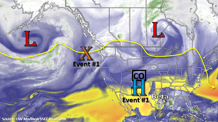
Tropical Storm Beta can be seen in the water vapor imagery below near Texas. Beta should be making landfall in Texas later today/tonight, and slow storm motion is expected to produce local flooding issues over that area and also over southeast Louisiana. Over Colorado, a weak upper level ridge will begin to build in from the west today behind the departing trough, which can be seen over Manitoba below. Over the next couple of days, moisture and mid-level energy will rotate counterclockwise around the monsoon High to our south. This will allow scattered diurnal driven storms to develop over the mountains each afternoon. Little to no rainfall is expected for the valleys and adjacent plains as storms will likely dissipate as they move off the mountains. Additionally, a weak shortwave/trough (orange “X”) will move inland from the west, which could supply some added lift for more widespread storms on Tuesday. With steering winds becoming more westerly tomorrow, storms may spill into the immediate adjacent plains, but will likely only produce measurable rainfall over the elevated ridges.
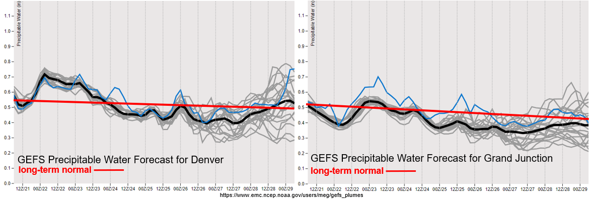
The elevated PW values over the state last for a couple of days before they fall to below normal values for late September (image below), which will reduce the chances of precipitation. Moisture return for Event #1 also looks to be larger east of the Continental Divide, which will mean greater coverage of storms. With the surface layer remaining on the drier end, higher cloud bases will allow for more evaporation to occur, which should keep rainfall accumulations below 0.75 inches tomorrow. So, there is No Apparent flood threat issued. Linger moisture on Wednesday may allow for another round of isolated storms over the mountains, but little to no accumulation is expected.
The ridging pattern maintains itself for the rest of the week, so dry and warming conditions are forecast. A peak in high temperatures is anticipated on Thursday (west) and Friday (east), so expect temperatures to be a couple degrees warmer during this period. The next incoming trough (south of Alaska) will pass north of us this weekend, but it looks to be a rather dry system. This means the chances for precipitation will not increase, and high surface winds could cause elevated and critical fire weather conditions with another lee cyclone developing. Additionally, cooler temperatures are likely behind the trough as it drops a cold front through the state this weekend. Moving into next week, flow becomes northwesterly behind the trough, so the cooler temperatures are likely hang around. Reminder that the flood season ends on September 30th, so Monday’s FTO will be the last of this season.
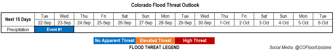
Event #1: Tuesday – Wednesday (9/22 – 9/23)
No Apparent flood threat as a shortwave and weak subtropical moisture combine for showers and weak thunderstorms.
Event #1 continues tomorrow with scattered storms anticipated over the mountains and eastern ridges. With moisture a little bit higher east, there’s a better chance for a couple thunderstorms to develop over the eastern mountains and Palmer/Raton Ridge. Storms will again be smaller in size but greater in coverage when compared to today, but the higher totals in the storm cores should continue to be isolated. Brief, gusty outflow winds and lightning will continue to be the main threats from the stronger storms that develop. Valleys and the adjacent plains may see a few sprinkles, but the more likely scenario is just an increase in cloud cover. As instability drops off with the setting sun, storm coverage will quickly begin to decrease. There is No Apparent flood threat issued.