Issue Date: Thursday, September 17th, 2020
Issue Time: 2:40PM MDT
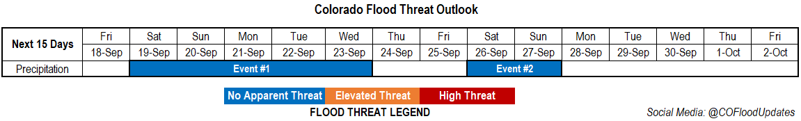
Valid Dates: 9/18 – 10/2
The persistent ridge will begin to break down this weekend. This is expected to return scattered showers to the mountains, and there may be a little rainfall for the lower elevations next week. The Low to our west will finally start to move inland tomorrow (Event #1), but as it tracks eastward it was also lift to the north. So, this means less rainfall over the weekend, and light precipitation should be confined to the northern mountains and Northwest Slope. Mid-level energy moves into the Four Corners region behind the trough, which should keep scattered showers in the forecast through mid-next week. This area of lift and increased moisture looks like it will slide south Thursday and Friday, so some scattered precipitation may be possible over the southern mountains, but it should be rain-free elsewhere. A more fall-like trough moves across the state after that (Event #2), so expecting precipitation chances to pick back up across the state. Long-term models are showing a lot of disagreement with the details for Event #2, so confidence is fairly low in the forecast.
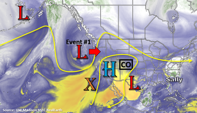
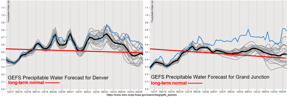
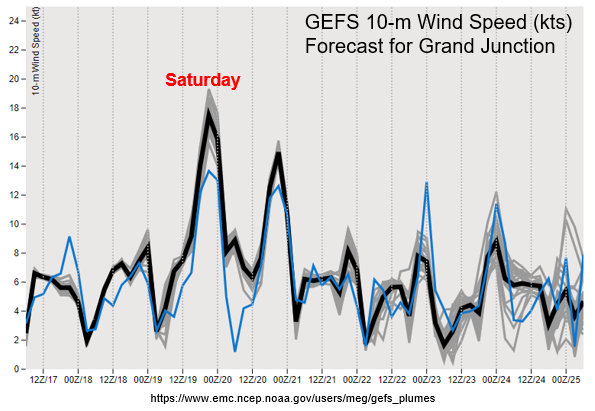
A couple more days of this mild and smoky weather before the Low arrives. This should increase moisture across the state to more normal values for this time of year, and help clear out some of the smoke with flow aloft shifting from the southwest. As the trough lifts north over the Great Basin, the jet stream could cause some stronger winds over western Colorado on Saturday (central and north). This can be seen in the 10-m wind speeds below reaching between 20 and 25 mph. While relative humidity will be a little higher further north, over central Colorado there could be some spotty elevated fire conditions. Lee troughing means that increased winds are also expected over the eastern plains. The plumes are also indicating a brief downtick in moisture on Sunday, which should keep showers mostly out of the forecast before picking back up over the mountains early next week. Overall, not looking like a ton of moisture with this system. The GFS continues to show the most rainfall activity, but there is No Apparent flood threat.
Event #1: Saturday – Wednesday (9/19 – 9/23)
No Apparent threat as cut off Low pushes the ridge south and brings scattered storms back to the mountains.
Looking like some increased cloud cover, slightly more seasonable temperatures, and an uptick in air quality this weekend. Scattered storms will return to the northern mountains and Northwest Slope Saturday evening, along with increased surface winds during the day. This could lead to some elevated fire conditions where relative humidity is lower. With the dry boundary layer, thinking rainfall efficiencies will be on the lower end, so there is No Apparent flood threat. A weak cold front on Saturday night will help to start to clear the smoke out and may cool temperatures a couple of degrees on Sunday over northern Colorado. Sunday will likely be pretty quiet on the rainfall front and storms that do form will likely produce little wetting rainfall over the mountains. Monday through Wednesday, scattered storms return to the forecast with some mid-level vorticity and moisture that linger in the area. Rainfall totals will again be on the lower end, but rain rates for burn areas will be watched on Tuesday and Wednesday. With steering flows gaining back a northerly and westerly component by Wednesday, storms may spill into the immediate, adjacent plains. Scattered storms may linger over the southern mountains on Thursday and Friday, but lighter totals are anticipated at this time.
Event #2: Saturday – Sunday (9/26 – 9/27)
No Apparent threat as the next fall-like Low drops south across the state.
Low confidence this far out for the details of this forecast, but all models are showing another stronger trough moving across the state. The strength of the Low is unknown, but it will likely be another fall-like cool off as the end of September nears. All models are showing some rainfall for this event, and the majority of the rainfall will likely be over the higher terrains. The GFS, as usual, is showing the most rainfall for this event. Be sure to tune back in next week as the forecast details will continue to change.