Issue Date: Thursday, September 24th, 2020
Issue Time: 3PM MDT
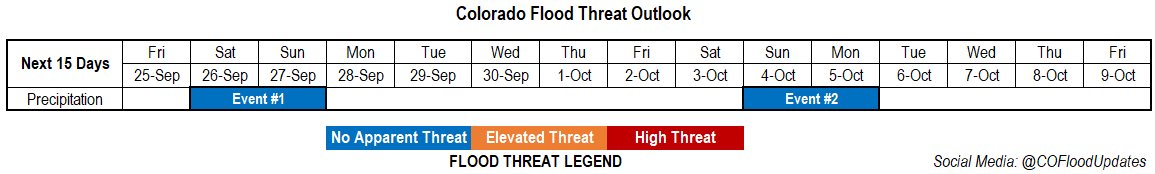
Valid Dates: 9/25 – 10/9
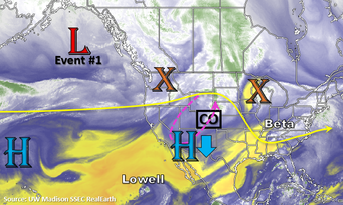
The main weather concern over the next couple of days will be critical and elevated fire weather as the shortwave trough and associated jet move inland. This will help tighten the pressure gradient over the state and produce windy conditions on both Friday and Saturday. Elevated and critical fire weather are forecast within the pink dashed line below where high temperatures will help create low humidity as this relatively dry system approaches. A Red Flag Warning has already been issued for tomorrow over the northwest quadrant of the state.
Sometime on Saturday or early Sunday, a cold front will dig south as an omega block begins to set up over the western US. This is expected to help lower the fire danger and cool temperatures off for Sunday. This will also be the only window for precipitation chances to increase. Colorado should be on the east side of this feature next week, so increasing northwesterly flow aloft will help disturbances pass through the flow. Very dry air fills in behind the front, so no precipitation is forecast, just more seasonable temperatures.
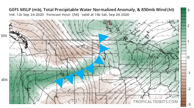
Below is the GEFS PW anomaly (green is positive) and 850mb winds forecast for Saturday afternoon. There is a slight moisture increase along and right behind the front, but a lot of dry air behind that. That translates to a limited window for increased precipitation chances. Light precipitation will be possible along and behind the front as it passes overhead. The GEFS keeps conditions drier on Sunday, but the ECM has been trending towards a wetter solution as a stronger front develops over the state. Either way, there is No Apparent flood threat as the rainfall will likely be more stratiform in nature. For this event, areas east of the Continental Divide will have a greater chance for accumulation.
Event #2, more or less, is just to mark when the omega block begins to break down. This will be when the chances for precipitation return, and likely marks the beginning of cooler weather. Until then, expect dry conditions with on and off temperature fluctuations as cold fronts ever so often pass through the northwesterly flow. At least it will begin to feel more like fall this next week.
Event #1: Saturday – Sunday (9/26 – 9/27)
No Apparent flood threat as a cold front drops through the state and will help generate lift for some showers.
Not much precipitation is expected for Event #1, and the majority of the accumulation will likely be over eastern Colorado. It’s also likely that we won’t reach 0.50 inches as the map indicates below. This polygon just marks the area with the greatest chance for measurable accumulation. If the system follows the GEFS solution, little to no rainfall is expected and the best chances for accumulation will be over the far eastern plains. If the developing front is a little stronger and wetter, some accumulation can be expected over the Southeast Mountains and elevated ridges. Either way, there is No Apparent flood threat due to more stratiform precipitation being forecast. Expect temperatures to be cooler on Sunday and into next week, but not before some 90Fs over the lower elevations on Friday and Saturday.