FTO 06-10-2021: Intense Heat Wave To Continue Through Next Week, With Possible Pattern Change Thereafter

Issue Date: Thursday, June 10th, 2021
Issue Time: 12:00PM MDT
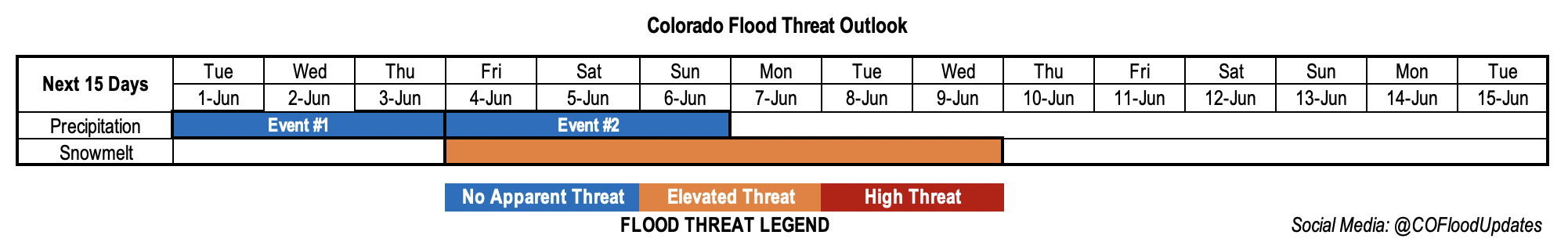
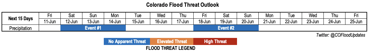
Valid Dates: 6/11-6/25

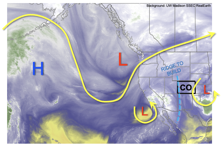
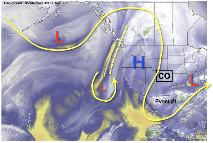
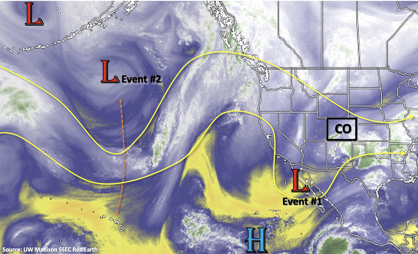
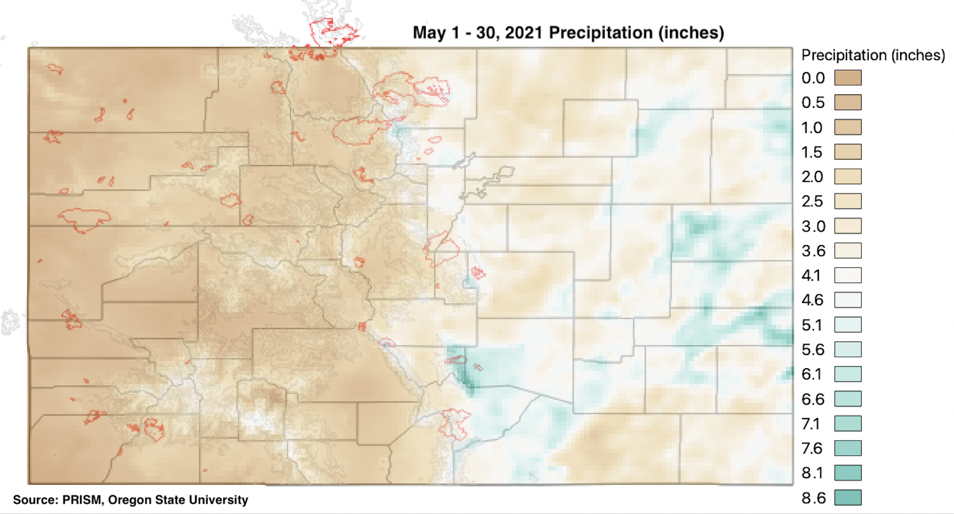
The cool, wet May that most of Colorado experienced is already a distant memory. Instead, an intense early-summer ridge of high pressure has resulted in temperature anomalies in western Colorado as much as 9-12F above normal over the past 7 days. Unfortunately, this Outlook has very little news on that front. As seen in the water vapor image, below, the upper-level ridge will re-strengthen right back after a brief cool down on Friday.

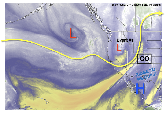
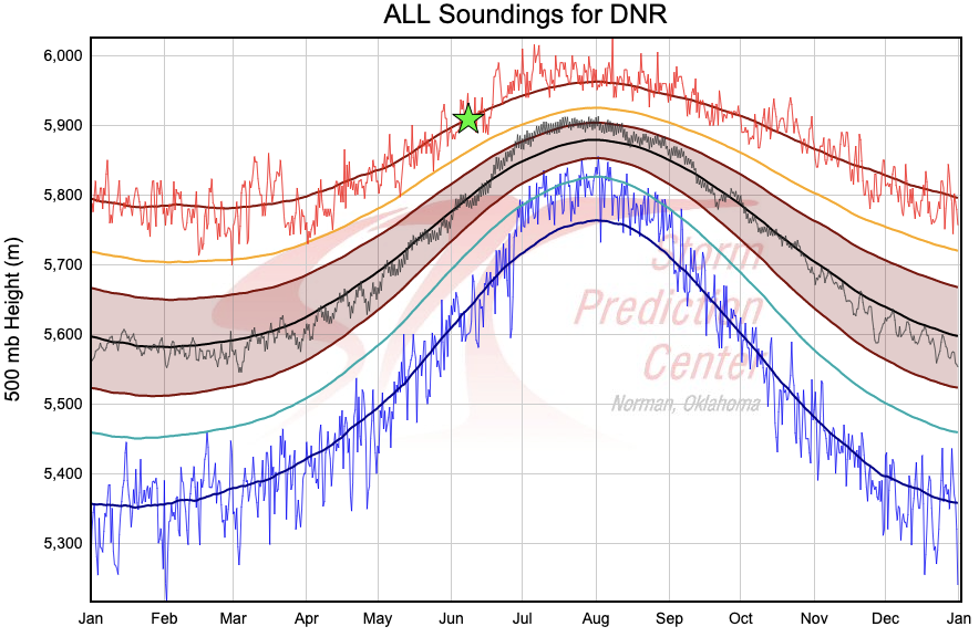
As shown in the climatology of 500-mb heights from over 50 years of soundings at Grand Junction, next Tuesday’s 500-mb height forecast of about 5980 meters (green star) will put that in record, or near-record territory for mid-June. As discussed previously, 500-mb heights are a very good predictor of surface temperatures, so we expect another 5-7 days of intense heat statewide. Temperatures of 10F above seasonal normal level will be commonplace, though a few days could approach anomalies of 20F above normal. This will translate to high temperatures approaching 100F for locations below 5,500 feet in elevation.

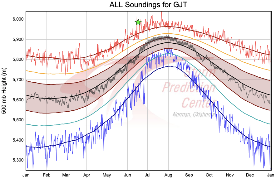
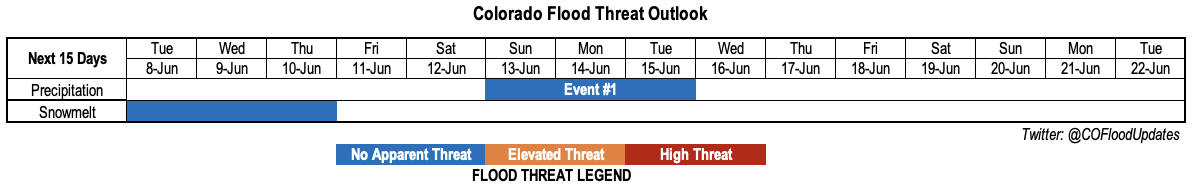
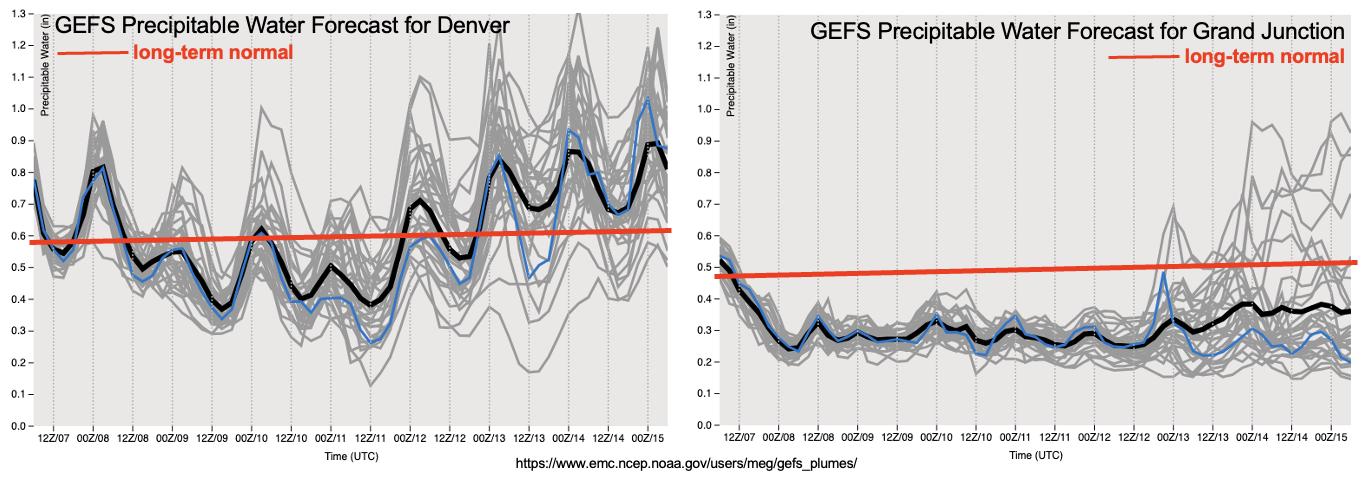
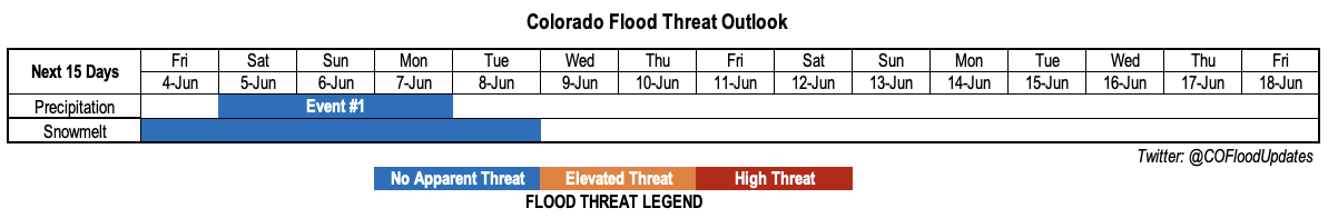
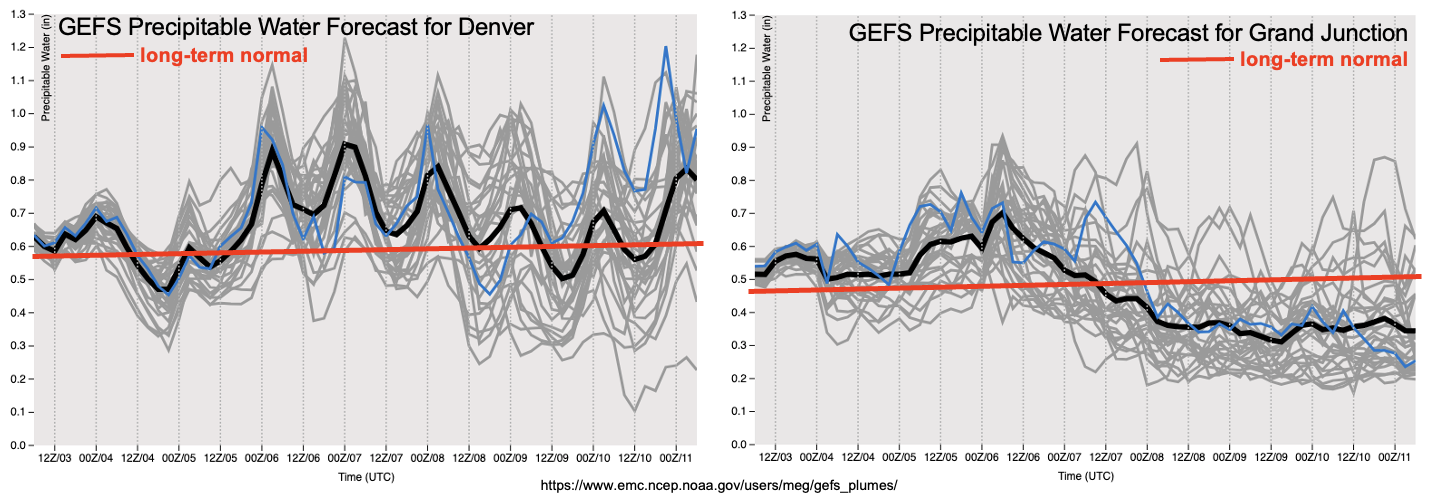
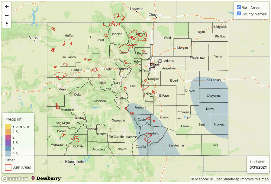
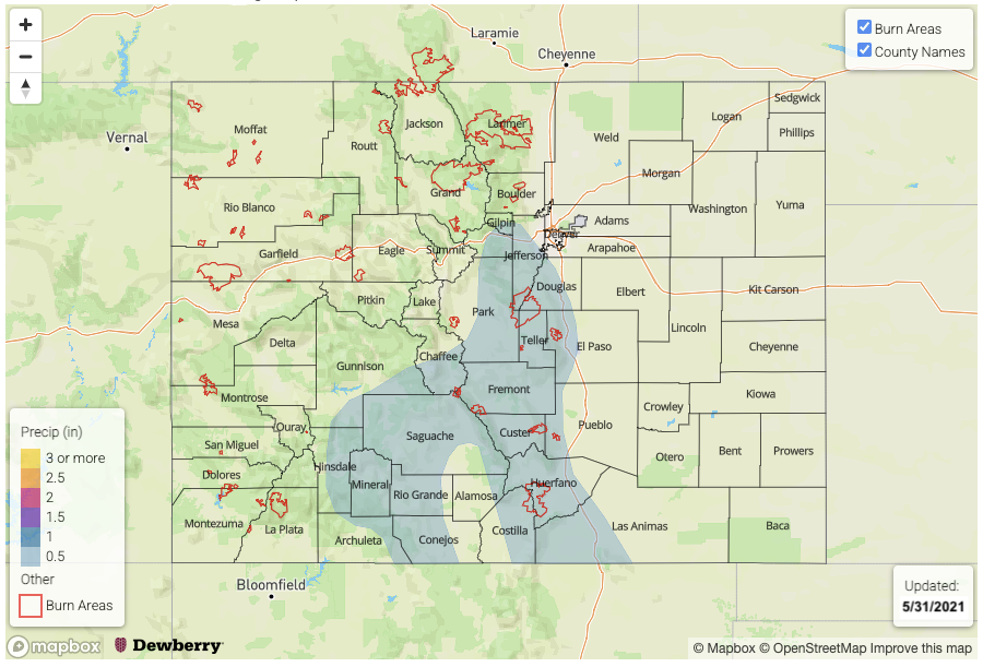
In Colorado, the other critical factor to consider in summertime precipitation forecasting is moisture. As shown below, after a brief period of intense drying following the shortwave passage on Friday, PW will gradually increase both east and west of the Continental Divide. Although the ridge will put a strong constraint on precipitation intensity and coverage, we have still identified two precipitation Events over the next 15-days. Event #1 will be after the shortwave passage where residual moisture will be leftover in southeast Colorado, resulting in isolated to scattered afternoon showers and weak storms there. After a long stretch of hot, mainly dry weather, Event #2 will see an increase in showers and storms next weekend mainly over the southern high terrain. From the atmospheric perspective, this event has somewhat of a monsoonal character to it which could mean the start of good news for the drought stricken southwest part of the state. However, it is far too early to proclaim that this is the start of the summer monsoon.

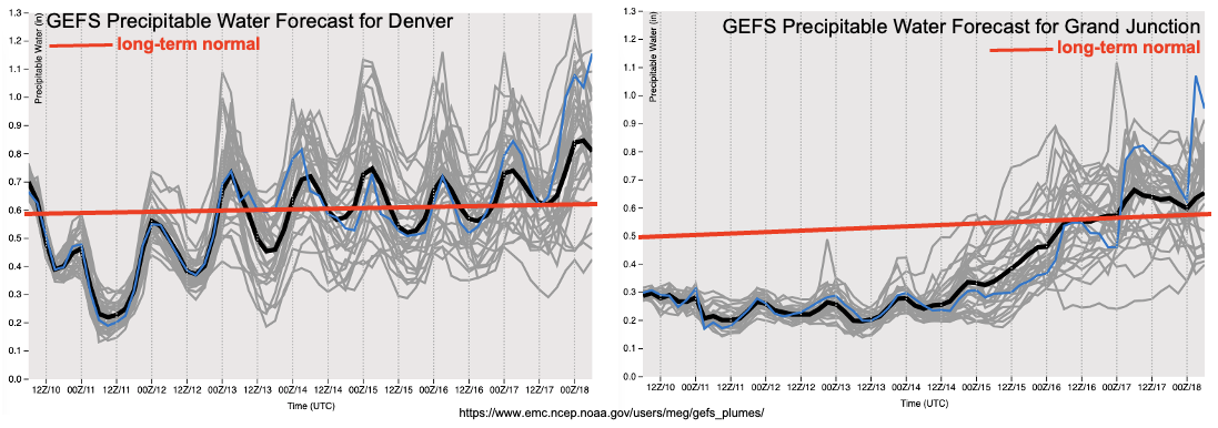
Below, we discuss the identified precipitation events in more detail.

Event #1: Saturday – Monday (June 12 – June 14)

Isolated to scattered showers and weak storms over Raton Ridge and Southeast Mountains, but No Apparent Flood Threat at this time

At this time, the best coverage appears to be over higher elevations on Saturday and Sunday with max 1-hour rain rates up to 0.6 inches possible. On Monday, it is possible that some storms could propagate further east into the Southeast Plains but this will depend on subtle features in the flow. In any cases, flooding is NOT expected with this event.

Event #2: Friday – Sunday (June 18 – June 20)

An increase in afternoon thunderstorms mainly over southern high terrain; No Apparent Flood Threat at this time

There is still significant uncertainty regarding whether the strong ridge will break down as quickly as current forecasts suggest. But if so, a resurgence of afternoon shower and storm activity is expected over the San Juans, Southeast Mountains and Raton Ridge, in consistency with monsoonal-type climatology. However, with marginal moisture and limited shear, only short-duration, “popcorn” type storms are expected capable of 0.5 inches of rainfall over 30 minutes or so. There is also uncertainty as to how far north the moisture will make it, so currently only southern Colorado appears to see meaningful precipitation chances. Flooding is currently NOT expected with this event.

FTO 06-07-2021: Prolonged Heat Wave, Especially West Of Continental Divide; Brief Relief Next Weekend

Issue Date: Monday, June 7th, 2021
Issue Time: 12:45PM MDT
Valid Dates: 6/8-6/22


The sudden transition to summer heat across Colorado will unfortunately not just be a temporary feature. As shown in the water vapor image, below, a large-scale trough will anchor itself off the North American west coast over at least the next 7 days, allowing for a reemergence of a very strong ridge centered over the Continental Divide. In turn, this will allow for a prolonged period of much above normal temperatures to the tune of 5-15F every day over the course of at least the next 7-10 days, and possibly even longer.

A cut-off low, currently off the southern California coast will merge back into the large-scale flow and quickly skirt across northwest Colorado over the next 72 hours. However, it’s primary impact will be to allow for the infiltration of very dry air into our state from the subtropical Pacific Ocean. This can be seen in the forecast PW plumes at Denver, and especially at Grand Junction where a prolonged stretch of significantly below normal PW is expected. It is likely that this will raise the threat of wildfires especially during days with gusty winds. Overall, we expect very little precipitation even across the climatologically favored higher terrain.

East of the Continental Divide, a cool front passage is expected on Friday, 6/12, after which some return moisture will likely find its way into Colorado from the south and east. This will allow for at least a temporary resurgence of marginal instability, which will support scattered shower and thunderstorm activity mainly over the higher terrain east of the Continental Divide. Some spill over into the eastern plains is possible, though that remains uncertain at this point. Overall, there’s enough consensus to identify a precipitation Event #1 for next weekend. However, at this time, less than 1.0 inch of precipitation is expected over the course of the event. Thus, there is No Apparent Flood Threat.

With the very hot weather expected this week, the last of higher elevation snow should melt over the next few days. A check of major river flows this afternoon does not show any flooding concerns as the snowmelt has been spread out over a long enough duration to prevent build up of melt water.

Below, we discuss the identified precipitation event in more detail.

Event #1: Sunday – Tuesday (June 13 – June 15)

Showers and storm coverage to increase mainly over higher terrain, but No Apparent Flood Threat at this time

Moisture will increase east of the Continental Divide with PW expected to be in the 0.7-1.1 inch range beginning Sunday. This will allow for the re-emergence of scattered showers and thunderstorms across climatologically favored higher terrain of the Front Range, Palmer Ridge, Southeast Mountains and Raton Ridge. With relatively week steering flow and sheer expected, most activity will be in the pulse variety type, with up to 0.5 inches of rainfall over a 30 minute period possible. Some organization of activity could occur given the presence of surface frontal features and dynamics aloft, which would allow for an eastward extension of storms off the higher terrain and into the Northeast and Southeast Plains. Overall though, only up to 1.0 inch of precipitation, locally, is expected at this point. Thus, flooding is NOT expected.

FTO 06-03-2021: Heat To Take Over Colorado, Rainfall Limited

Issue Date: June 3rd, 2021
Issue Time: 11:30AM MDT
Valid Dates: 6/4-6/18

As discussed in the previous Outlook, after a generally cool and rain May, very significant changes are on the way for Colorado’s weather. As shown in the water vapor image, below, a very strong ridge has set up shop over the western United States. Thus far, it has stayed far enough west that Colorado’s temperatures have stayed close to seasonal normal. However, numerous daily and even monthly all-time heat records have been set in CA, NV, ID, OR and WA, an impressive feat given that it is still very early in the month and climatological averages rise sharply through the month of June.

The aforementioned strong ridge will shift east-northeast over time and also expand rapidly eastward, which will cause much warmer weather across our entire state. The chart below shows the climatology of 500mb heights taken from Denver soundings dating back to the 1940s. The 500mb level is roughly 20,000ft above sea level (~15,000 feet above ground level in Denver or Grand Junction), and the exact height of this level correlates fairly strongly to the average temperature from the ground to that height. The green star in the chart below shows the forecast 500mb height over Colorado next week, which is expected to approach or exceed 5,900 meters (19,400 feet). This high of a value would place it near record territory for early June, which is why we expect much above normal temperatures to persist beginning tomorrow. High temperatures above 100F will be possible next week in lower elevations if current forecasts hold.

Although very hot temperatures are typically associated with dry weather in Colorado, a big caveat is that there is a significant pool of residual moisture in place over the southwest United States from the passage of the previous disturbance. In fact, this disturbance, Event #1, will actually “retrograde” slightly to the west and advect moisture into southern Colorado (see water vapor image above). As shown in the PW forecast plumes, below, both Denver and Grand Junction will experience above normal to significantly above normal moisture content over the next 72-96 hours. While the ridge will undoubtedly limit the efficiency of rainfall generation, we nonetheless expect daily rounds of mainly higher elevation showers and weak storms especially over the southern high terrain. However, only short-term light to moderate intensity rainfall is expected, thus there is No Apparent Flood Threat with Event #1. Longer-range guidance suggests the persistence of the strong ridge somewhere over the west-central United States, which would keep our temperatures significantly above normal for the duration of the next 7-14 days. Thus, no additional organized precipitation events are foreseen.

Lastly, with the much above normal temperatures, we expect the snow melt season to generally wind down by early next week. The South Platte River basin still has widespread high-elevation areas with 10+ inches of Snow Water Equivalent. With this expected to melt out to the tune of 2+ inches of SWE per day, smaller tributaries could certainly see some minor flooding along river banks. However, with the absence of meaningful precipitation, we do not foresee any major flooding concerns at this time.

Below, we discuss the identified precipitation event in more detail.

Event #1: Saturday-Monday (June 5 – June 7)

Daily pulses of light to moderate intensity showers and storms, but No Apparent Flood Threat

Scattered shower and weak thunderstorm activity will occur in daily afternoon and evening pulses, mainly limited to the higher terrain of the San Juans and Southeast Mountains with lower coverage and weaker intensity for the Central Mountains and Northern Mountains. Limited instability will be partially counteracted by weak steering flow to produce max 1-hour rainfall up to perhaps 0.50 inches locally. Over the 72-hour period, a few lucky locations could receive close to 1 inch, but the norm will be more in the 0.25-0.50 inch range.

At this time, it does not appear that lower elevations (on either side of the Continental Divide) will see much if any rainfall as warm mid-level temperature will inhibit convection.

FTO 05-31-2021: Scattered Mountain Showers and Warming Temperatures

Issue Date: Monday, May 31st, 2021
Issue Time: 3PM MDT
Valid Dates: 6/1 – 6/15

Today’s FTO is defined by a much larger amplitude atmospheric pattern and longer transitions between each event. Starting tomorrow, CO’s flow aloft will changeover to north/northwesterly as we move under the influence of the ridge just to our west in the image below. Being located on the east side of the ridge, the north/northwesterly flow aloft will help move some subtle disturbances through the flow each afternoon (Event #1). The ridge builds directly overhead by Friday and into this weekend (Event #2), which will help to produce summer-like temperatures statewide and increase snowmelt at the higher elevations. Residual moisture under the ridge should help create isolated diurnal driven storms over the mountains each afternoon.

By early next week, an omega block looks like it may set up. This would produce a dry, southwesterly flow across the state originating from the Desert Southwest, quickly mix out any remaining moisture and cease rainfall chances to start the work week. With the jet possibly moving overhead by Tuesday afternoon, increased fire danger may be an issue with the very dry air mass overhead.

Residual moisture should allow scattered storms to develop over the mountains each day and the elevated ridges on Tuesday for Event #1. With PW just slightly above normal to start the week (east and west), only light to moderate rainfall is forecast for the mountains. Slightly higher totals will be possible over the adjacent eastern plains tomorrow as storms develop on the elevated ridges and move into higher dew points. However, there is No Apparent flood threat.

For Event #2, there’s quite a bit of spread in models regarding the moisture that remains underneath the ridge. Slow steering flows will allow the diurnally driven storms to drop a little more rainfall for Event #2, especially if PW remains on the higher end. However, equal chance that the storms produce minimal and localized rainfall. A cold front looks to move across the state on Sunday as the next trough moves ashore and pushes the ridge east. This will be the best chance for more widespread storm coverage, but there is No Apparent flood threat for Event #2.

It has certainly been a wet May over eastern Colorado. Below are the precipitation totals across the state from May 1st to May 30th (PRISM). The wet mountains, western Raton Ridge and eastern plains got an incredible soaking over the last 30 days with totals between 6 to ~8.5 inches. For the eastern plains, this is the equivalence of about a 1 in 50-year event. Stage IV data (not shown) has some border counties reaching 10 inches, which as discussed during the last FTO, is about a 1 in 100-year event. The Wet Mountains are a climatological hot spot in May, so the totals below indicate a much higher average recurrence interval (1 in 5-year event). Hoping for a wet June out west, although noting that climatologically, rainfall dips down in June before the monsoon kicks in for July and August.

Streamflow

Went ahead and put an Elevated flood threat for streamflow at the end of this week into this weekend. With the summer temperatures in the forecast for multiple days, expecting an uptick in the base flows. It’s a sightly earlier than normal peak flow this season, but overall, it’s still looking like we will avoid flooding issues on the major rivers. As mentioned previously, flooding issues will likely be minor and again affect the smaller rivers/streams over northern Colorado (North Platte/South Platte Basins). Nonetheless, we’ll continue to track heavy or long duration rainfall during the peak flows over the next couple of weeks. None of which are in the forecast as of Memorial Day.

Event #1: TuesdayThursday (6/1 – 6/3)

No Apparent flood threat as diurnal driven storms with some mid-level lift develop with residual moisture.

Best chance for more widespread storms will be on Tuesday, although coverage will be less than today. Expect storms to fire over the mountains and elevated ridges by early afternoon. It looks like it should remain dry over western Colorado until Thursday/Friday. For tomorrow, rain rates over the eastern mountains could reach up to 0.30 inches/hour range. Over the Palmer Ridge and Southeast Plains, rain rates up to 0.75 inches/hour will be possible. Small hail, gusty outflow winds and dangerous lightning will be the main threats from storms that develop tomorrow. Less rainfall is forecast for Wednesday and Thursday with accumulation sticking to the mountains with the more northerly steering flows. Flooding is not forecast.

Event #2: FridaySunday (6/4 – 6/6)

No Apparent flood threat as a ridge builds overhead and then is pushed east by an incoming trough.

It will be a hot weekend with an increase in moisture progged first west then east starting on Friday. More widespread storms for the mountains are forecast on Saturday, although accumulations look minimal. On Sunday, it looks like the best chance of rainfall will be over the southeast quadrant of the state as a weak frontal boundary drops through the state. Higher CAPE over the Southeast Plains may allow for severe storm or two over the border counties during this period.