Issue Date: Monday, May 31st, 2021
Issue Time: 3PM MDT
Valid Dates: 6/1 – 6/15
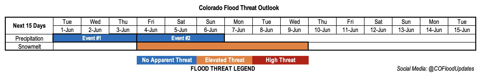
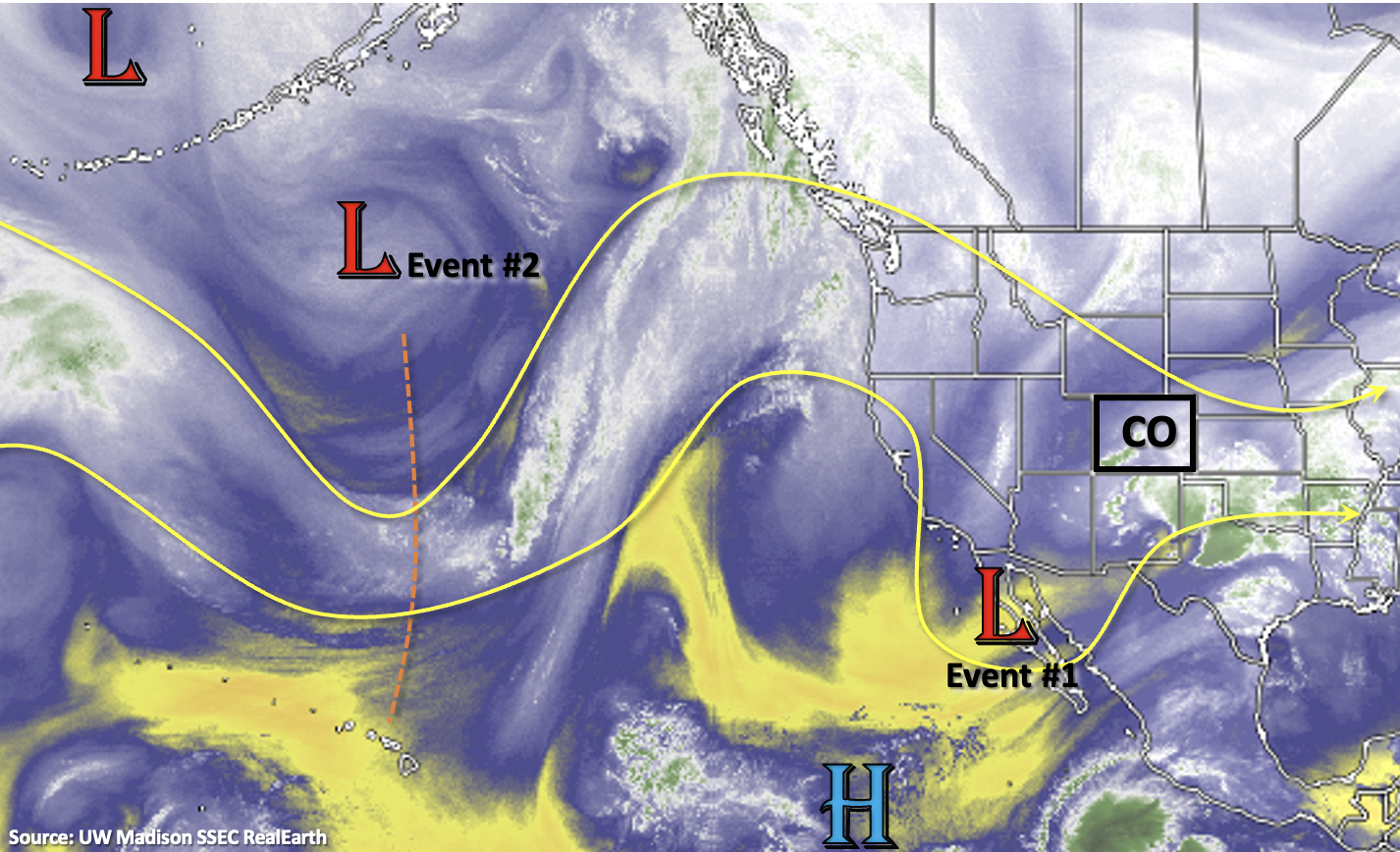
Today’s FTO is defined by a much larger amplitude atmospheric pattern and longer transitions between each event. Starting tomorrow, CO’s flow aloft will changeover to north/northwesterly as we move under the influence of the ridge just to our west in the image below. Being located on the east side of the ridge, the north/northwesterly flow aloft will help move some subtle disturbances through the flow each afternoon (Event #1). The ridge builds directly overhead by Friday and into this weekend (Event #2), which will help to produce summer-like temperatures statewide and increase snowmelt at the higher elevations. Residual moisture under the ridge should help create isolated diurnal driven storms over the mountains each afternoon.
By early next week, an omega block looks like it may set up. This would produce a dry, southwesterly flow across the state originating from the Desert Southwest, quickly mix out any remaining moisture and cease rainfall chances to start the work week. With the jet possibly moving overhead by Tuesday afternoon, increased fire danger may be an issue with the very dry air mass overhead.
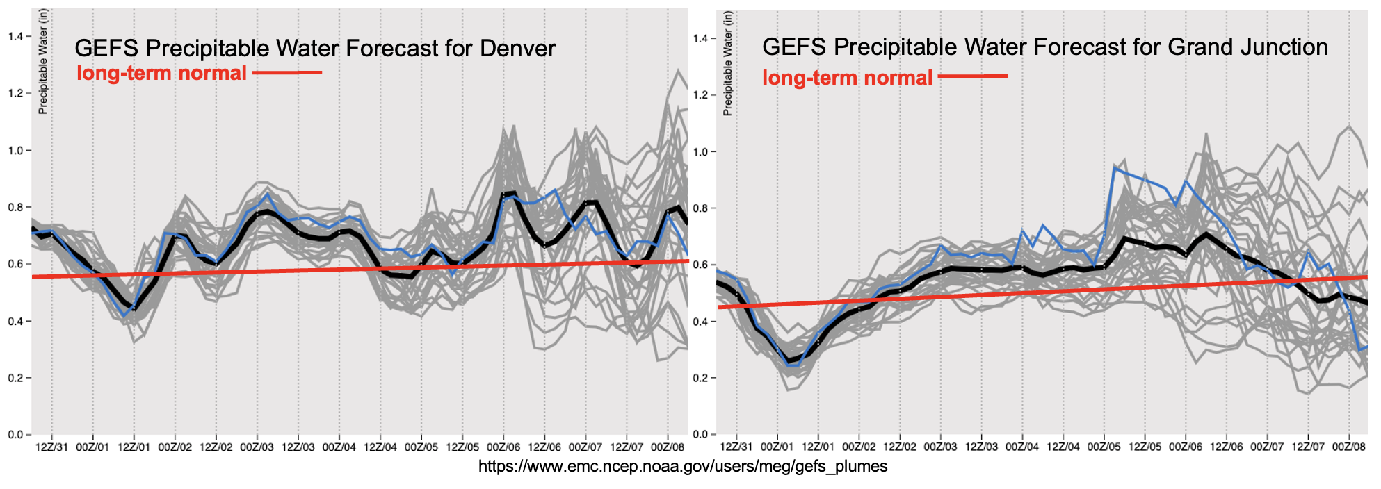
Residual moisture should allow scattered storms to develop over the mountains each day and the elevated ridges on Tuesday for Event #1. With PW just slightly above normal to start the week (east and west), only light to moderate rainfall is forecast for the mountains. Slightly higher totals will be possible over the adjacent eastern plains tomorrow as storms develop on the elevated ridges and move into higher dew points. However, there is No Apparent flood threat.
For Event #2, there’s quite a bit of spread in models regarding the moisture that remains underneath the ridge. Slow steering flows will allow the diurnally driven storms to drop a little more rainfall for Event #2, especially if PW remains on the higher end. However, equal chance that the storms produce minimal and localized rainfall. A cold front looks to move across the state on Sunday as the next trough moves ashore and pushes the ridge east. This will be the best chance for more widespread storm coverage, but there is No Apparent flood threat for Event #2.
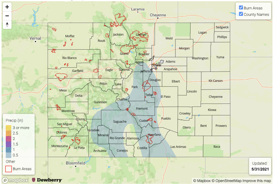
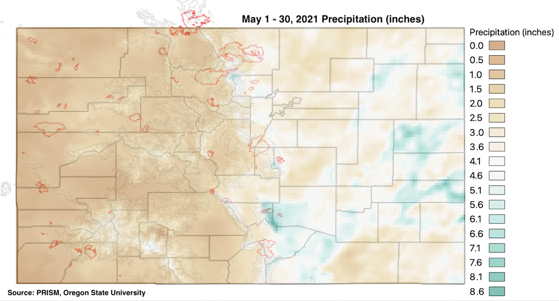
It has certainly been a wet May over eastern Colorado. Below are the precipitation totals across the state from May 1st to May 30th (PRISM). The wet mountains, western Raton Ridge and eastern plains got an incredible soaking over the last 30 days with totals between 6 to ~8.5 inches. For the eastern plains, this is the equivalence of about a 1 in 50-year event. Stage IV data (not shown) has some border counties reaching 10 inches, which as discussed during the last FTO, is about a 1 in 100-year event. The Wet Mountains are a climatological hot spot in May, so the totals below indicate a much higher average recurrence interval (1 in 5-year event). Hoping for a wet June out west, although noting that climatologically, rainfall dips down in June before the monsoon kicks in for July and August.
Streamflow
Went ahead and put an Elevated flood threat for streamflow at the end of this week into this weekend. With the summer temperatures in the forecast for multiple days, expecting an uptick in the base flows. It’s a sightly earlier than normal peak flow this season, but overall, it’s still looking like we will avoid flooding issues on the major rivers. As mentioned previously, flooding issues will likely be minor and again affect the smaller rivers/streams over northern Colorado (North Platte/South Platte Basins). Nonetheless, we’ll continue to track heavy or long duration rainfall during the peak flows over the next couple of weeks. None of which are in the forecast as of Memorial Day.
Event #1: Tuesday – Thursday (6/1 – 6/3)
No Apparent flood threat as diurnal driven storms with some mid-level lift develop with residual moisture.
Best chance for more widespread storms will be on Tuesday, although coverage will be less than today. Expect storms to fire over the mountains and elevated ridges by early afternoon. It looks like it should remain dry over western Colorado until Thursday/Friday. For tomorrow, rain rates over the eastern mountains could reach up to 0.30 inches/hour range. Over the Palmer Ridge and Southeast Plains, rain rates up to 0.75 inches/hour will be possible. Small hail, gusty outflow winds and dangerous lightning will be the main threats from storms that develop tomorrow. Less rainfall is forecast for Wednesday and Thursday with accumulation sticking to the mountains with the more northerly steering flows. Flooding is not forecast.
Event #2: Friday – Sunday (6/4 – 6/6)
No Apparent flood threat as a ridge builds overhead and then is pushed east by an incoming trough.
It will be a hot weekend with an increase in moisture progged first west then east starting on Friday. More widespread storms for the mountains are forecast on Saturday, although accumulations look minimal. On Sunday, it looks like the best chance of rainfall will be over the southeast quadrant of the state as a weak frontal boundary drops through the state. Higher CAPE over the Southeast Plains may allow for severe storm or two over the border counties during this period.