Issue Date: Thursday, June 10th, 2021
Issue Time: 12:00PM MDT
Valid Dates: 6/11-6/25
The cool, wet May that most of Colorado experienced is already a distant memory. Instead, an intense early-summer ridge of high pressure has resulted in temperature anomalies in western Colorado as much as 9-12F above normal over the past 7 days. Unfortunately, this Outlook has very little news on that front. As seen in the water vapor image, below, the upper-level ridge will re-strengthen right back after a brief cool down on Friday.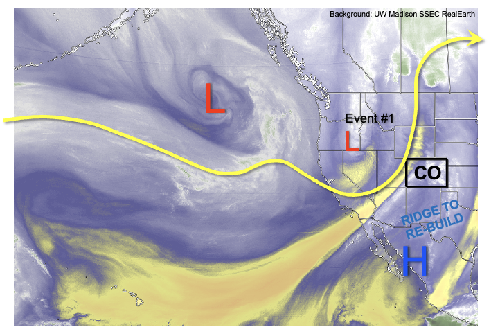
As shown in the climatology of 500-mb heights from over 50 years of soundings at Grand Junction, next Tuesday’s 500-mb height forecast of about 5980 meters (green star) will put that in record, or near-record territory for mid-June. As discussed previously, 500-mb heights are a very good predictor of surface temperatures, so we expect another 5-7 days of intense heat statewide. Temperatures of 10F above seasonal normal level will be commonplace, though a few days could approach anomalies of 20F above normal. This will translate to high temperatures approaching 100F for locations below 5,500 feet in elevation.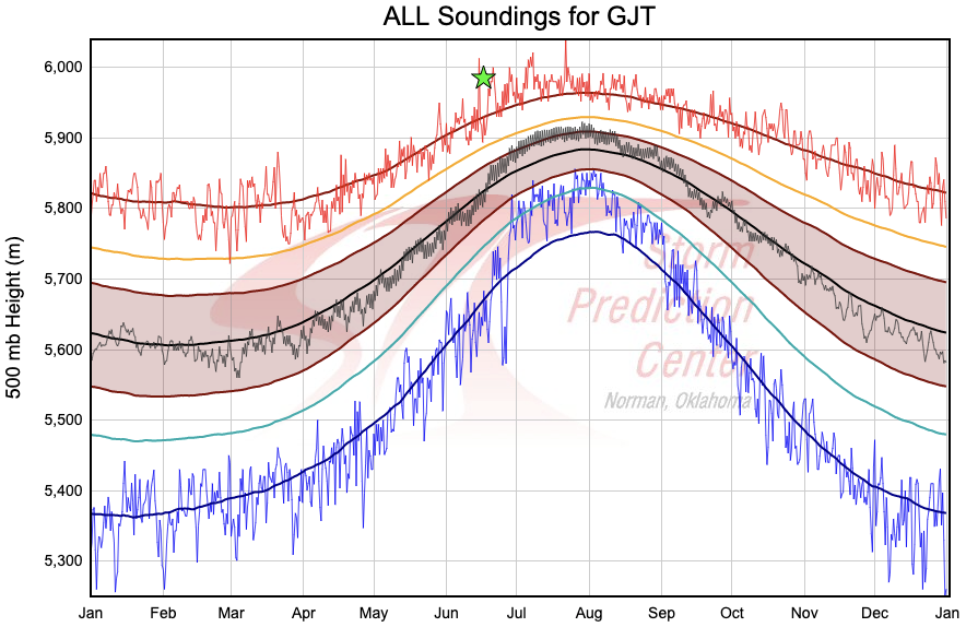
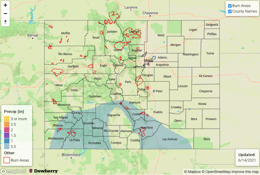
In Colorado, the other critical factor to consider in summertime precipitation forecasting is moisture. As shown below, after a brief period of intense drying following the shortwave passage on Friday, PW will gradually increase both east and west of the Continental Divide. Although the ridge will put a strong constraint on precipitation intensity and coverage, we have still identified two precipitation Events over the next 15-days. Event #1 will be after the shortwave passage where residual moisture will be leftover in southeast Colorado, resulting in isolated to scattered afternoon showers and weak storms there. After a long stretch of hot, mainly dry weather, Event #2 will see an increase in showers and storms next weekend mainly over the southern high terrain. From the atmospheric perspective, this event has somewhat of a monsoonal character to it which could mean the start of good news for the drought stricken southwest part of the state. However, it is far too early to proclaim that this is the start of the summer monsoon.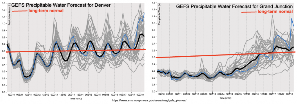
Below, we discuss the identified precipitation events in more detail.
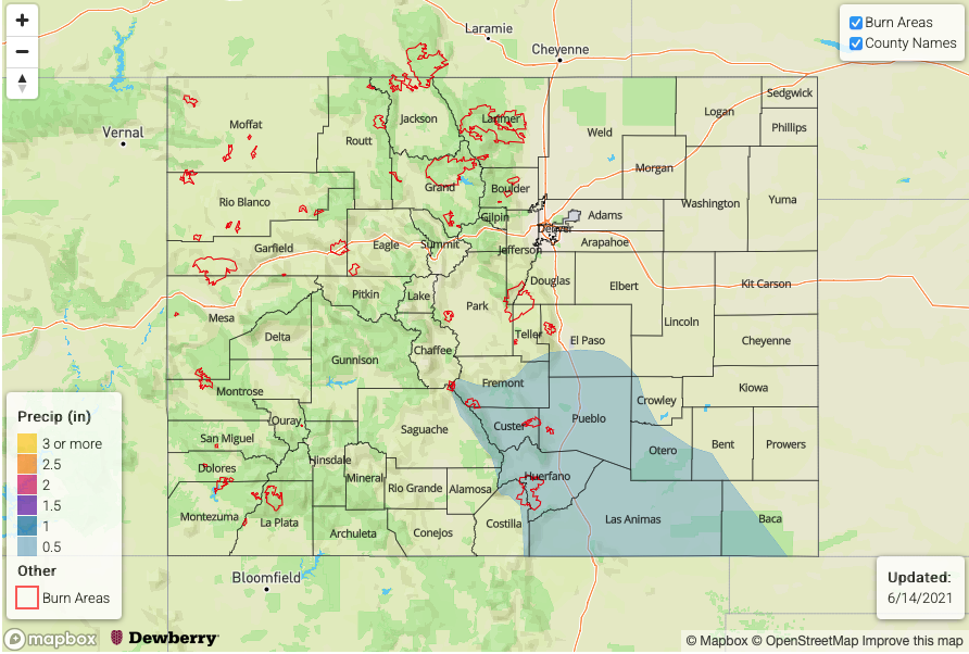
Event #1: Saturday – Monday (June 12 – June 14)
Isolated to scattered showers and weak storms over Raton Ridge and Southeast Mountains, but No Apparent Flood Threat at this time
At this time, the best coverage appears to be over higher elevations on Saturday and Sunday with max 1-hour rain rates up to 0.6 inches possible. On Monday, it is possible that some storms could propagate further east into the Southeast Plains but this will depend on subtle features in the flow. In any cases, flooding is NOT expected with this event.
Event #2: Friday – Sunday (June 18 – June 20)
An increase in afternoon thunderstorms mainly over southern high terrain; No Apparent Flood Threat at this time
There is still significant uncertainty regarding whether the strong ridge will break down as quickly as current forecasts suggest. But if so, a resurgence of afternoon shower and storm activity is expected over the San Juans, Southeast Mountains and Raton Ridge, in consistency with monsoonal-type climatology. However, with marginal moisture and limited shear, only short-duration, “popcorn” type storms are expected capable of 0.5 inches of rainfall over 30 minutes or so. There is also uncertainty as to how far north the moisture will make it, so currently only southern Colorado appears to see meaningful precipitation chances. Flooding is currently NOT expected with this event.
