FTO 09-15-2022: Late Season Monsoon Event Becoming More Likely Next Week

Issue Date: Thursday, September 15th 2022
Issue Time: 11:45PM MDT
Valid Dates: 9/16 – 9/30

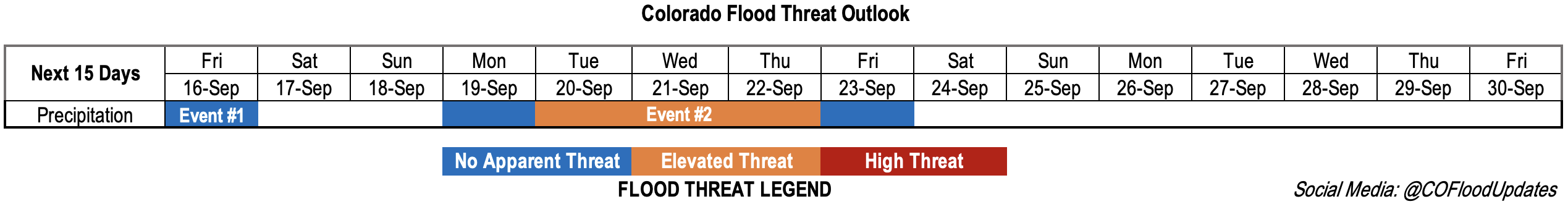
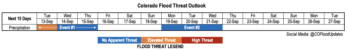
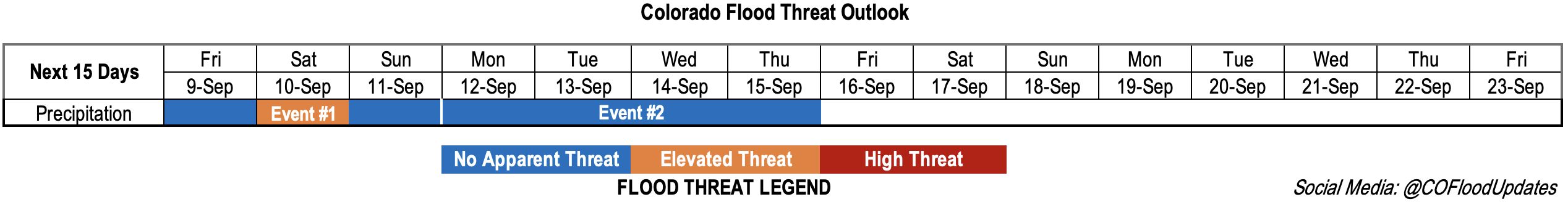
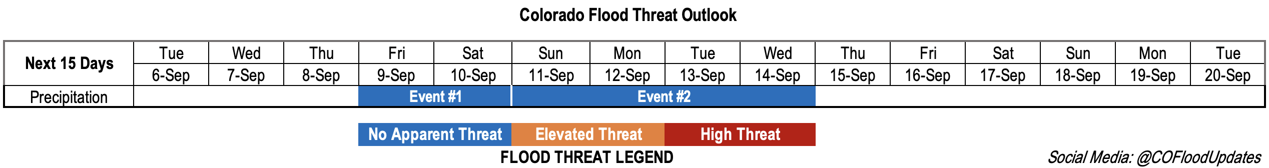
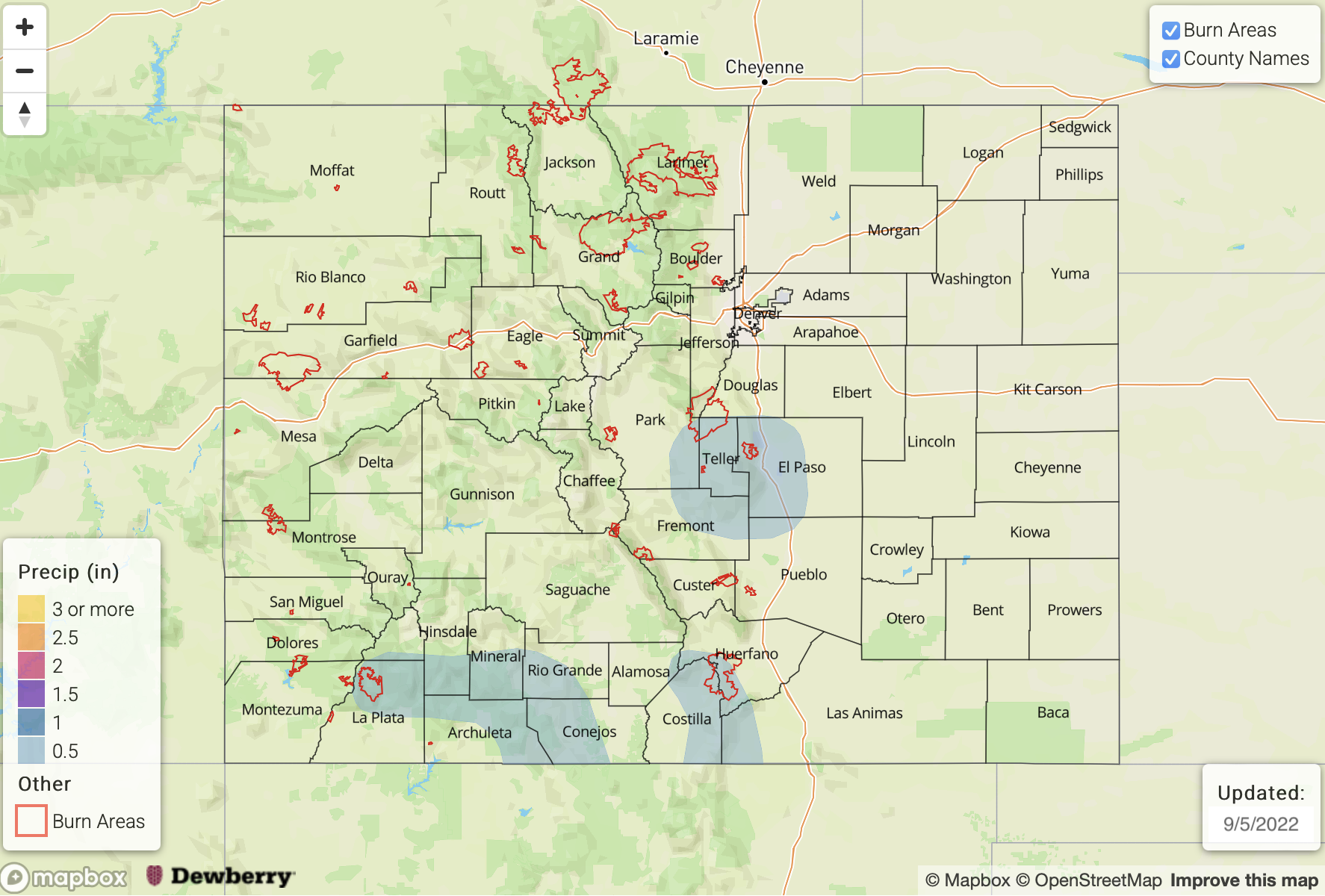
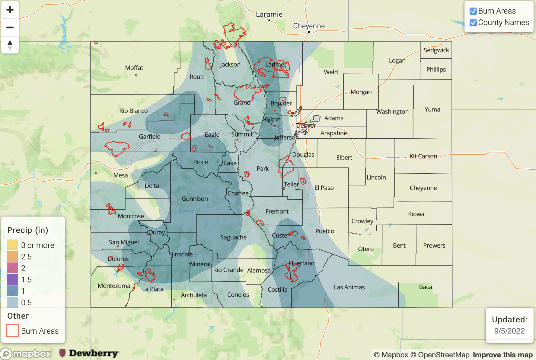
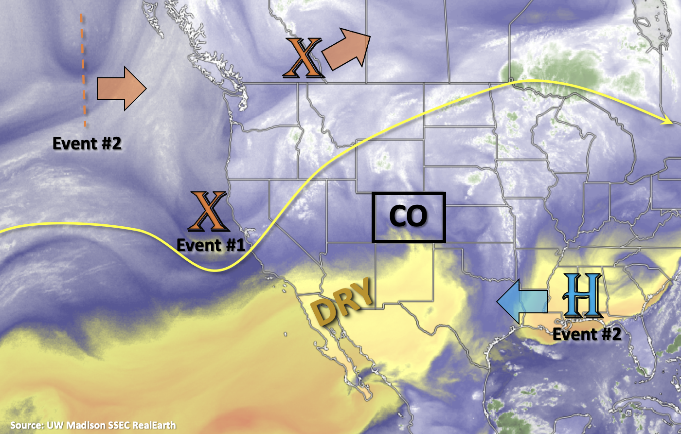
Just when you thought the monsoon season was over, mother nature decides to toss you another late season heavy rainfall event. But first, there’s going to be a quick 1-day event before a drying and warming trend begins for the weekend. For Event #1, a bit of mid-level lift is expected to track across the northern portion of the state, which should help produce some widely scattered showers north of I-70 with residual moisture from this last system. Due to decreasing moisture and moderate to quick WSW storm motion, there is No Apparent threat issued. As we head into the weekend, High pressure is forecast to begin to rebuild over Texas/Oklahoma. This should produce both drier and warmer conditions for most of the state, but weak, isolated mountain showers may develop in the afternoons. By early next week, a few daily high temperature records may be broken over the far eastern plains as temperatures potentially reach into the mid to upper-90s °F for the area.

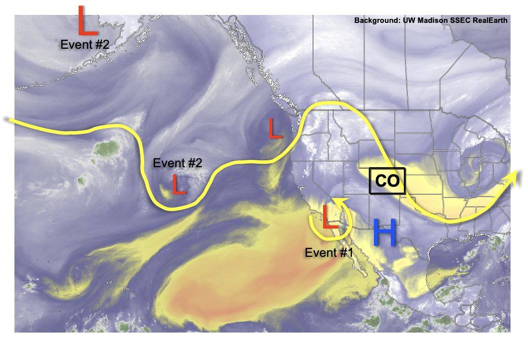
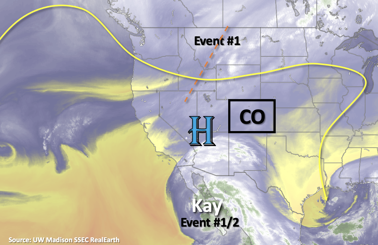
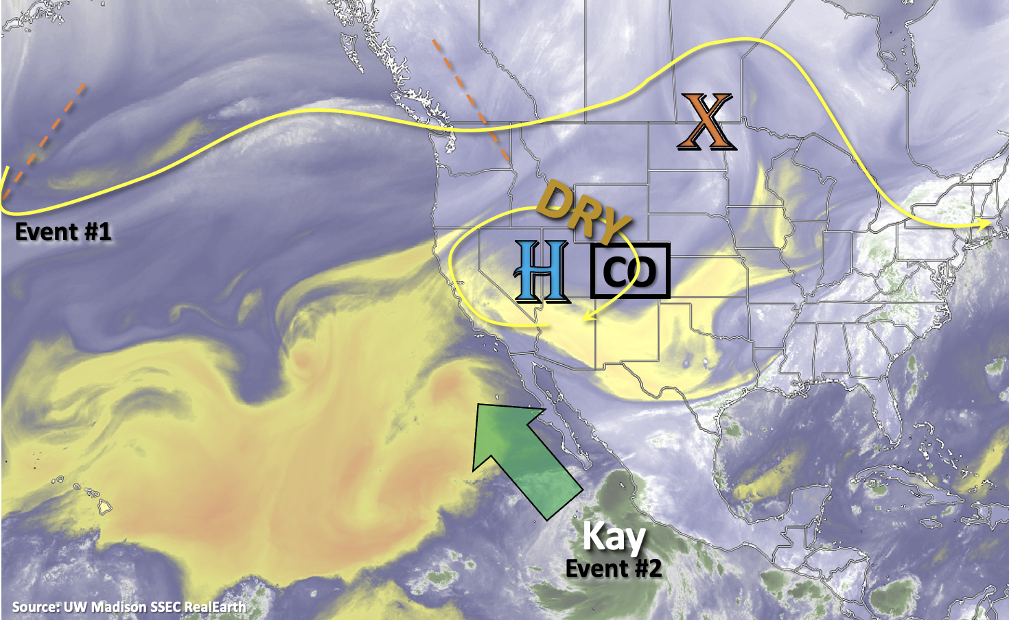
Event #2 will likely begin late on Monday into Tuesday after a cutoff Low sets up off the west coast. It’s becoming more likely that the counterclockwise rotation from the Low paired with clockwise rotation around the High (over Texas/Oklahoma) will produce strong southerly flow that will extended in to Colorado. If this occurs, as long-term guidance is suggesting, it will likely transport a late season subtropical moisture plume northwards and into the state.

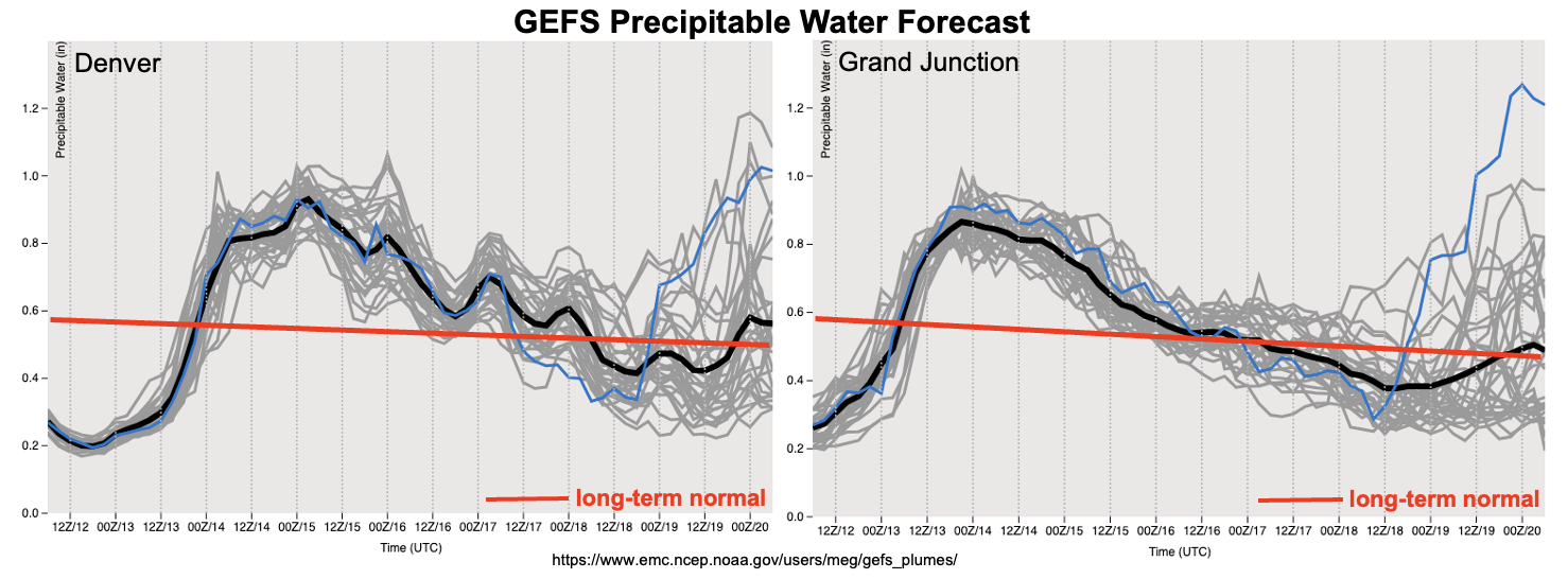
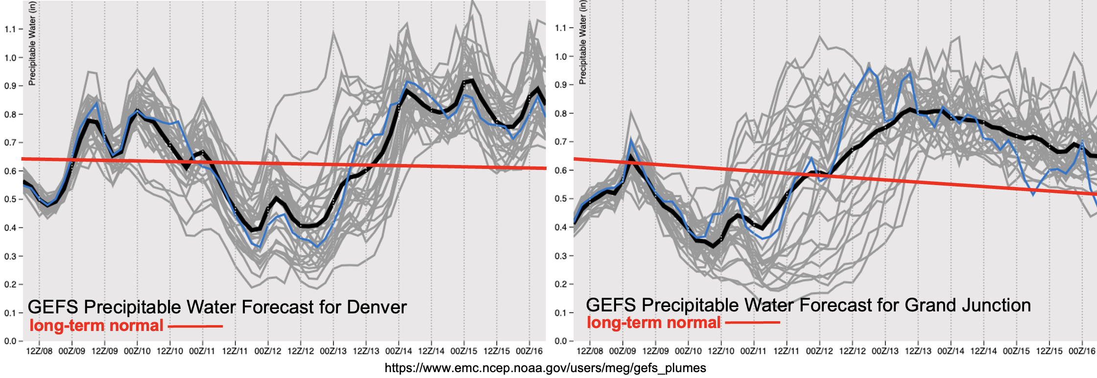
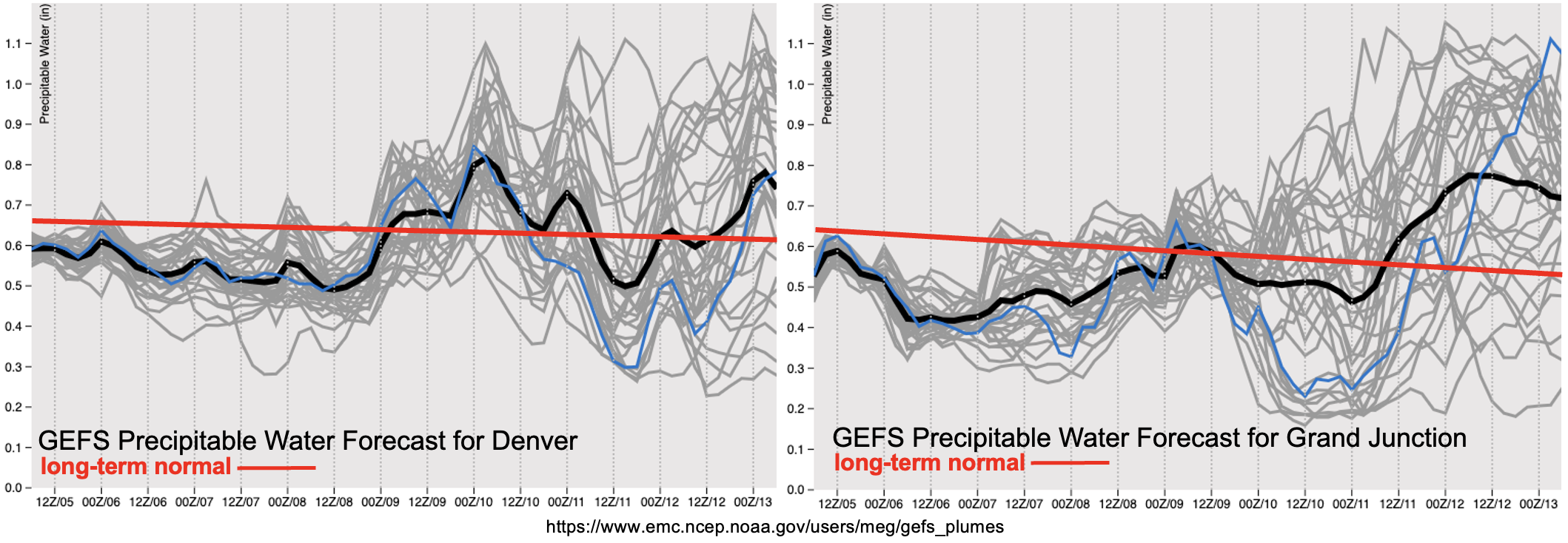
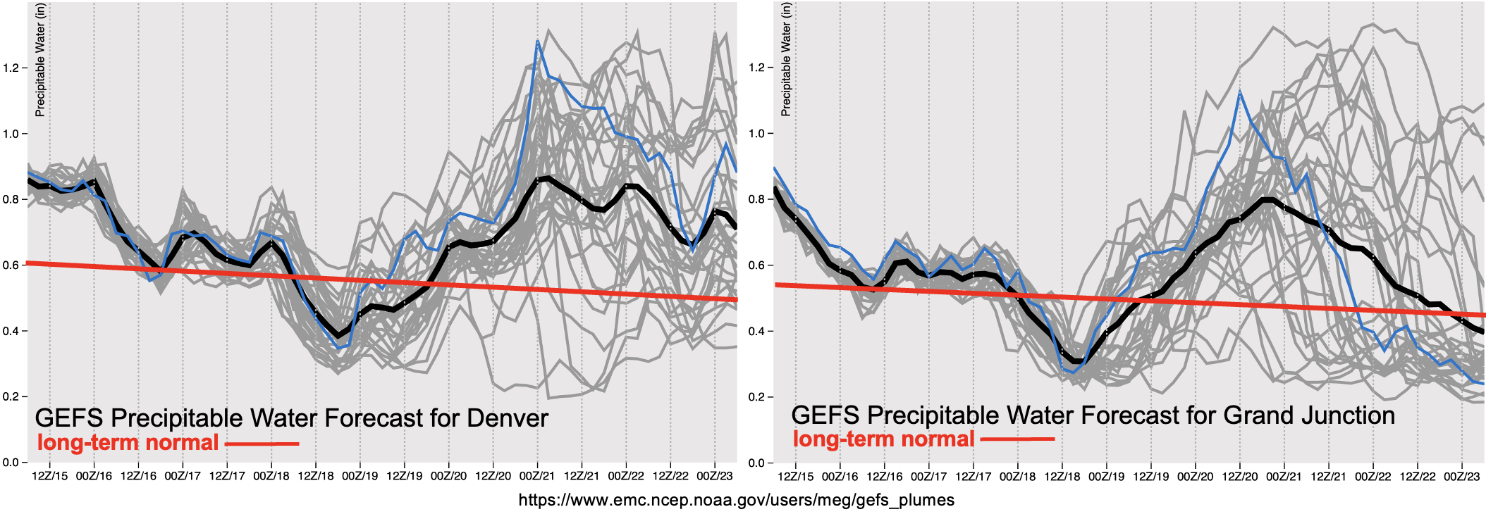
The GEFS plumes below show the nice decrease in moisture that is forecast over the weekend, and paired with subsidence from the High, this should cause a downtick in the chance for precipitation. Looking ahead to Event #2, there is fairly good consensus between model members that PW values will increase over the state by mid-week. With both east and west PW values well above average during this period, an Elevated flood threat has been issued. There are still plenty of differences between model members regarding the magnitude of moisture, since this event is 5-7 days out, but there may need to be 1 to 2-day upgrade to a High threat in Monday’s FTO.

Scroll down to view more details about the two events outlined in today’s FTO.

Event #1: Friday (9/16)

Residual moisture and mid-level lift are likely to produce widely scattered storms over northern Colorado, but there is No Apparent flood threat issued.

Widely scattered showers are likely tomorrow over the northern tier of the state favoring the high terrain for coverage. Over the adjacent plains, rainfall is expected to be more isolated. Max 30-minute rain rates up to 0.75 inches may be possible. With only isolated brief and moderate rainfall rates anticipated, there is No Apparent flood threat at this time. In addition to rainfall, stronger storms that develop are likely to produce some brief windy conditions and lightning.

Event #2: Monday – Friday (9/19 – 9/23)

Long-term guidance is suggesting a late season monsoon surge, which will cause an Elevated flood threat to be issued.

Confidence is increasing that there will be a late season monsoon event next week. Longer duration accumulation may cause some flooding issues during this period. Initially, storms are expected to occur over western Colorado with the San Juan/Central Mountains most likely to accumulate the highest totals. As the trough moves east, the plume should shift with it, so it’s likely that the eastern mountains will get in on the rainfall action by mid-week. The GEFS even has some members producing rainfall over the eastern plains later in the week, but it’s a bit too far out to have much confidence in that forecast. Plenty of details are likely to change with this event still being 5-7 days out, but the peak in rainfall activity and coverage is currently estimated to occur between Tuesday and Thursday. Be sure to tune back into the FTO on Monday for an up to date forecast.

FTO 09-12-2022: A Couple Of Rain Events, Separated By Late Summer Heat

Issue Date: Monday, September 12th, 2022
Issue Time: 1:50PM MDT
Valid Dates: 9/13-9/27

Although it will end up taking quite a while, the remnants of Hurricane Kay will eventually make it to Colorado! As shown in the water vapor image, below, the cut-off circulation over southern California is the legacy of the previously named tropical cyclone. In tandem with another disturbance off the US Pacific Northwest coastline, these features will combine to transport a plume of moisture over Colorado (Event #1). Relatively fast steering flow will offset the sharp spike in PW to near 1 inch. While widespread to numerous showers and storms are in the forecast for western Colorado beginning tomorrow, the primary flood threat looks to be of the low-end variety for a brief time on Tuesday. At that instance, there may be sufficient instability along with the prospect of training storms to produce excessive runoff over steeper terrain of the San Juan and Central Mountains. However, by later on Tuesday afternoon, continuing into Wednesday and Thursday, the precipitation mode will be showers with weaker embedded storms. Nonetheless, this event will be mighty welcome to ward off any wildfire threat as we head into our climatologically drier months statewide.

As seen in the GEFS forecast PW plumes, below, the spike in moisture will be transient with a quick return to drier conditions by this weekend. Meanwhile, a building upper-level ridge of modest strength over the southern Great Plains will allow for a return to above normal temperatures, at least for a few days. By Saturday, for example, eastern Colorado will see high temperatures likely exceed 90F for elevations below 5,500 feet. Given that it is mid-September, this equates to about 10F above seasonal normal. Fortunately, as can somewhat be seen in the forecast PW plumes, rainfall chances (and cooler temperatures) look to return to the state by the early to middle part of next week. The degree of moisture return carries significant uncertainty and will depend on the dynamics of two disturbances currently over the central Pacific. Some guidance is suggestive of deep southerly flow over the Four Corners, which could yield PW approaching 1 inch along with heavier rainfall chances. However, the most likely outcome at this time is for southwesterly flow, which would have modest PW though possibly active dynamics. The latter scenario would yield scattered rain (and snow!) showers with embedded storms possible. This is the preferred outcome at this time, with No Apparent flood threat.

The identified precipitation events are described in more detail below.

Event #1: Tuesday – Thursday (September 13 – September 15)

Early, Low-End Elevated Flood Threat, Followed By Cooler Weather With Showers & Weak Storms

Widespread showers and thunderstorms are expected mainly along and west of the Continental Divide on Tuesday. Max 1-hour rain rates up to 1.2 inches are possible, along with max 3-hour rainfall up to 1.6 inches. Thus, a low-end Elevated flood threat may be needed, mainly during the afternoon hours on Tuesday for the higher terrain of the San Juan and Central Mountains. By later Tuesday, cloud cover and cooler temperatures aloft will quickly reduce instability, leading to mostly showers with a few embedded storms possible. And yes, by late Tuesday, we are expecting rain to change to snow for very high elevations of western Colorado, above 12,000 feet!

By Wednesday, a cooler boundary layer over western and central Colorado will limit instability. Although weaker storms are possible, rain rates will be of the light to perhaps briefly moderate variety. Thus, flooding is not expected on Wednesday, though widespread precipitation is likely. The snow level will continue to drop Wednesday, down to perhaps 10,000 feet over far western Colorado ranges.

By Thursday, moisture will begin to drop as drier air infiltrates back into the state. The last remnants of showers will be winding down.

Over the entire event, up to 2.0 inches of precipitation is expected for isolated parts of the Central, Northern and San Juan Mountains. East of the Continental Divide, precipitation will be limited with perhaps up to 0.5 inches of rainfall possible over parts of northeast Colorado.

Event #2: Monday – Wednesday (September 19 – September 21)

Showers And Weak Storms To Return, But No Apparent Flood Threat At This Time

Another plume of subtropical moisture looks to bring back precipitation chances across mainly central and western Colorado by early next week. At this time, there is too much uncertainty to prepare a precipitation map, and rainfall is expected to remain below 0.5 inches.

FTO 09-08-2022: Return of Rainfall & A Meaningful Cool-Down

Issue Date: Thursday, September 8th 2022
Issue Time: 2:45PM MDT
Valid Dates: 9/9 – 9/23

Heading into tomorrow, there should be some relief from this unseasonably hot start to September. After several days of broken temperature records, a cold front is expected to slide through the state tonight. This should help drop high temperatures several degrees over portions of eastern Colorado tomorrow, but to a lesser extent for areas west of the Continental Divide. A secondary and stronger cold front is forecast to push through late on Friday and into Saturday, which should more effectively reduce statewide temperatures for the weekend. This is all thanks to the passage of an upper-level trough which can be seen by the orange dashed line in the water vapor imagery below (Event #1). As the trough passes through, Hurricane Kay will continue to move northwards. Kay will likely help increase moisture across the southern border beginning tomorrow. On Saturday, the increase in dynamics from the trough and moisture from Kay may combine, which could cause a localized, low-end Elevated flood threat to be issued for portions of the southern high terrain. A few ingredients that would need to come together for the threat would be clear skies, warmer temperatures (south), and timing of the frontal passage/location of its associated dynamics. Additionally, near surface moisture will need to substantially increase to help produce more efficient rain rates.

The EPS has a slightly longer lull when compared to the GEFS before Event #2 begins early next week. It looks like another incoming, albeit weaker, trough will help to push the remnants of Hurricane Kay over the state from west to east. With a higher likelihood of the remaining moisture being located mainly in the mid and upper-levels of the atmosphere and the addition of faster steering flows and ongoing cloud cover limiting instability, means there is No Apparent threat issued at this time.

The PW plumes from the GEFS are now showing better consensus with the return of moisture for Event #1 (east) and for Event #2 (statewide). With the lower levels of the atmosphere likely remaining quite dry and less instability during Event #1, outside of the southern high terrain, there is No Apparent flood threat issued. As Event #2 begins, PW values are likely to rise to above normal values east and west, which translates into scattered to numerous storms returning to the forecast. At this time, not anticipating a lot of instability or too high of dew points, which means that the rain rates should only be light to moderate. So, there is No Apparent flood threat issued for Event #2.

Event #1: Friday – Sunday (9/9 – 9/11)

One day Elevated flood threat as some subtropical moisture and dynamics potentially combine over the southern high terrain.

The isolated to widely scattered storms on Friday into the overnight hours should mostly be confined to the northern and southern mountains. There may be some spillover possible near the elevated ridges with more zonal steering flows and dynamics present during the late afternoon and overnight hours. Best chance for precipitation accumulation will be across the southern high terrain, east of the Continental Divide where max 1-hour rain rates may reach up to 0.75 inches. By Saturday, cooler and more stable conditions along with widespread cloud cover are anticipated for much of the state. Best chance for some higher rain rates will be over the central and southern high terrain again with some spillover of storms possible into the immediate adjacent Southeast Plains. Rain rates may reach just over an inch an hour, so an Elevated flood threat has been issued. Elsewhere, light stratiform rainfall and mist is expected.

Event #2: MondayThursday (9/12 – 9/15)

Remnants of Kay should drift overhead from the west to east and cause an uptick in shower and storm coverage, but there is No Apparent flood threat issued.

Long-term guidance still has some differences with the timing of the increase in moisture from the remnants of Kay, but there is increasing confidence that there will be an uptick in storms and showers next week. The most scattered to widespread rainfall activity is likely to occur on Tuesday and Wednesday. Without much instability and surface moisture forecast at this time, not thinking there will be much of a heavy rainfall threat. Details about the final location of Kay and the timing of the next trough are likely to change, so be sure to tune back into the FTO on Monday as there might need to be a 1-day upgrade to the flood threat.

FTO 09-05-2022: Hot & Dry To Start The Work Week With A Cool Down Likely Friday

Issue Date: Monday, September 5th 2022
Issue Time: 1PM MDT
Valid Dates: 9/6 – 9/20

Yesterday marked the 85th consecutive day of precipitation occurring somewhere within the state. There were two weak mountain storms that developed during the late afternoon over Saguache and Gunnison County. Even though these storms likely only caused minimal accumulation, they helped keep the precipitation streak alive. Not sure how much longer the count can keep going since it’s going to be a hot and dry start to the work week.

The first part of this week will feature an anomalous strong upper-level High, which will promote subsidence and continue to pull in a dry air mass from the north. During this period, only very isolated showers over the mountains may be possible with limited residual moisture. With the High’s grip over the state, afternoon temperatures are expected to remain much above average through Thursday. In fact, several areas may break their daily record high temperatures throughout the week. By the end of the week, a trough is expected to drop a very welcomed cold front through the state, which should help cool temperatures and return precipitation chances to the forecast (Event #1). Sunday will likely serve as a transition day between events before the remnants of Tropical Cyclone Kay potentially move into the state (Event #2). Uncertainty continues in the forecast for Event #2, but there is increasing confidence that there will be an uptick in rainfall chances at the beginning of next week.

The PW plumes show below average values both east and west with the dry air mass overhead to start the forecast period (black line below red line). Even though the week is expected to start off quite dry and hot, lighter surface winds are anticipated under the ridge, which should help to suppress fire weather. While Event #1 looks to return moisture and some dynamics to the state, it looks like this event should be mostly confined to areas along and east of the Continental Divide. After Event #1, both plumes indicate that there is a good likelihood for a lull in moisture, and thus precipitation chances on Sunday. Then, Event #2 potentially kicks off as remnants of TC Kay move from west to east across the state. The large spread in ensemble members (gray lines) indicate uncertainty in the magnitude of moisture, but there will likely be an upward trend in PW, which should cause precipitation chances to increase next week. Currently, there is No Apparent flood threat, but we’ll be keeping an eye on the upper bounds of the potential moisture surge throughout the week.

Event #1: Friday – Saturday (9/9 – 9/10)

No Apparent flood threat with limited moisture and dynamics over eastern Colorado.

Best chance for precipitation during this event will be across the southern high terrain and elevated Palmer Ridge area where isolated max 1-hour rain rates may reach between 0.5 and 0.75 inches. There is a smaller chance for widely scattered storms over the adjacent plains, and with quick storm movement and limited surface moisture, any storms that do develop should pose more of a wind than heavy rainfall threat. Therefore, there is No Apparent flood threat issued at this time.

Event #2: SundayWednesday (9/11 – 9/14)

Remnants of tropical moisture may drift overhead from the west and cause an uptick in rainfall chances, but currently, there is No Apparent flood threat issued.

Long-term guidance is now showing TC Kay tracking up the Baja Peninsula. The remnants of TC Kay may linger to our west and slowly increase PW values over the state. However, if the moisture and energy is able to track more quickly overhead, by way of a shortwave pushing it eastward, there is a higher chance for a low-end 1-day threat early next week. The likelihood of that happening is not high, so it’s more likely that the moisture will slowly move overhead and cause an uptick in precipitation chances first west, then east. Be sure to tune back into the FTO on Thursday as there may be better synoptic and mesoscale clarity for when and where the remnants of Kay will track.