Issue Date: Thursday, September 15th 2022
Issue Time: 11:45PM MDT
Valid Dates: 9/16 – 9/30
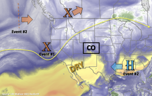
Just when you thought the monsoon season was over, mother nature decides to toss you another late season heavy rainfall event. But first, there’s going to be a quick 1-day event before a drying and warming trend begins for the weekend. For Event #1, a bit of mid-level lift is expected to track across the northern portion of the state, which should help produce some widely scattered showers north of I-70 with residual moisture from this last system. Due to decreasing moisture and moderate to quick WSW storm motion, there is No Apparent threat issued. As we head into the weekend, High pressure is forecast to begin to rebuild over Texas/Oklahoma. This should produce both drier and warmer conditions for most of the state, but weak, isolated mountain showers may develop in the afternoons. By early next week, a few daily high temperature records may be broken over the far eastern plains as temperatures potentially reach into the mid to upper-90s °F for the area.
Event #2 will likely begin late on Monday into Tuesday after a cutoff Low sets up off the west coast. It’s becoming more likely that the counterclockwise rotation from the Low paired with clockwise rotation around the High (over Texas/Oklahoma) will produce strong southerly flow that will extended in to Colorado. If this occurs, as long-term guidance is suggesting, it will likely transport a late season subtropical moisture plume northwards and into the state.
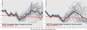
The GEFS plumes below show the nice decrease in moisture that is forecast over the weekend, and paired with subsidence from the High, this should cause a downtick in the chance for precipitation. Looking ahead to Event #2, there is fairly good consensus between model members that PW values will increase over the state by mid-week. With both east and west PW values well above average during this period, an Elevated flood threat has been issued. There are still plenty of differences between model members regarding the magnitude of moisture, since this event is 5-7 days out, but there may need to be 1 to 2-day upgrade to a High threat in Monday’s FTO.
Scroll down to view more details about the two events outlined in today’s FTO.
Event #1: Friday (9/16)
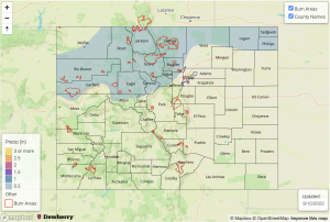
Residual moisture and mid-level lift are likely to produce widely scattered storms over northern Colorado, but there is No Apparent flood threat issued.
Widely scattered showers are likely tomorrow over the northern tier of the state favoring the high terrain for coverage. Over the adjacent plains, rainfall is expected to be more isolated. Max 30-minute rain rates up to 0.75 inches may be possible. With only isolated brief and moderate rainfall rates anticipated, there is No Apparent flood threat at this time. In addition to rainfall, stronger storms that develop are likely to produce some brief windy conditions and lightning.
Event #2: Monday – Friday (9/19 – 9/23)
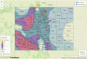
Long-term guidance is suggesting a late season monsoon surge, which will cause an Elevated flood threat to be issued.
Confidence is increasing that there will be a late season monsoon event next week. Longer duration accumulation may cause some flooding issues during this period. Initially, storms are expected to occur over western Colorado with the San Juan/Central Mountains most likely to accumulate the highest totals. As the trough moves east, the plume should shift with it, so it’s likely that the eastern mountains will get in on the rainfall action by mid-week. The GEFS even has some members producing rainfall over the eastern plains later in the week, but it’s a bit too far out to have much confidence in that forecast. Plenty of details are likely to change with this event still being 5-7 days out, but the peak in rainfall activity and coverage is currently estimated to occur between Tuesday and Thursday. Be sure to tune back into the FTO on Monday for an up to date forecast.


