Issue Date: Monday, September 12th, 2022
Issue Time: 1:50PM MDT
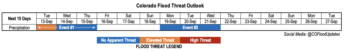
Valid Dates: 9/13-9/27
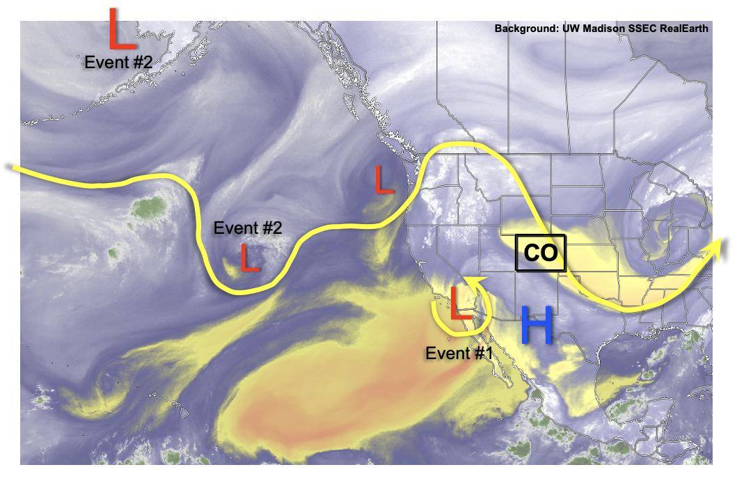
Although it will end up taking quite a while, the remnants of Hurricane Kay will eventually make it to Colorado! As shown in the water vapor image, below, the cut-off circulation over southern California is the legacy of the previously named tropical cyclone. In tandem with another disturbance off the US Pacific Northwest coastline, these features will combine to transport a plume of moisture over Colorado (Event #1). Relatively fast steering flow will offset the sharp spike in PW to near 1 inch. While widespread to numerous showers and storms are in the forecast for western Colorado beginning tomorrow, the primary flood threat looks to be of the low-end variety for a brief time on Tuesday. At that instance, there may be sufficient instability along with the prospect of training storms to produce excessive runoff over steeper terrain of the San Juan and Central Mountains. However, by later on Tuesday afternoon, continuing into Wednesday and Thursday, the precipitation mode will be showers with weaker embedded storms. Nonetheless, this event will be mighty welcome to ward off any wildfire threat as we head into our climatologically drier months statewide.
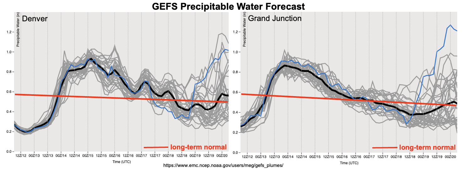
As seen in the GEFS forecast PW plumes, below, the spike in moisture will be transient with a quick return to drier conditions by this weekend. Meanwhile, a building upper-level ridge of modest strength over the southern Great Plains will allow for a return to above normal temperatures, at least for a few days. By Saturday, for example, eastern Colorado will see high temperatures likely exceed 90F for elevations below 5,500 feet. Given that it is mid-September, this equates to about 10F above seasonal normal. Fortunately, as can somewhat be seen in the forecast PW plumes, rainfall chances (and cooler temperatures) look to return to the state by the early to middle part of next week. The degree of moisture return carries significant uncertainty and will depend on the dynamics of two disturbances currently over the central Pacific. Some guidance is suggestive of deep southerly flow over the Four Corners, which could yield PW approaching 1 inch along with heavier rainfall chances. However, the most likely outcome at this time is for southwesterly flow, which would have modest PW though possibly active dynamics. The latter scenario would yield scattered rain (and snow!) showers with embedded storms possible. This is the preferred outcome at this time, with No Apparent flood threat.
The identified precipitation events are described in more detail below.
Event #1: Tuesday – Thursday (September 13 – September 15)
Early, Low-End Elevated Flood Threat, Followed By Cooler Weather With Showers & Weak Storms
Widespread showers and thunderstorms are expected mainly along and west of the Continental Divide on Tuesday. Max 1-hour rain rates up to 1.2 inches are possible, along with max 3-hour rainfall up to 1.6 inches. Thus, a low-end Elevated flood threat may be needed, mainly during the afternoon hours on Tuesday for the higher terrain of the San Juan and Central Mountains. By later Tuesday, cloud cover and cooler temperatures aloft will quickly reduce instability, leading to mostly showers with a few embedded storms possible. And yes, by late Tuesday, we are expecting rain to change to snow for very high elevations of western Colorado, above 12,000 feet!
By Wednesday, a cooler boundary layer over western and central Colorado will limit instability. Although weaker storms are possible, rain rates will be of the light to perhaps briefly moderate variety. Thus, flooding is not expected on Wednesday, though widespread precipitation is likely. The snow level will continue to drop Wednesday, down to perhaps 10,000 feet over far western Colorado ranges.
By Thursday, moisture will begin to drop as drier air infiltrates back into the state. The last remnants of showers will be winding down.
Over the entire event, up to 2.0 inches of precipitation is expected for isolated parts of the Central, Northern and San Juan Mountains. East of the Continental Divide, precipitation will be limited with perhaps up to 0.5 inches of rainfall possible over parts of northeast Colorado.
Event #2: Monday – Wednesday (September 19 – September 21)
Showers And Weak Storms To Return, But No Apparent Flood Threat At This Time
Another plume of subtropical moisture looks to bring back precipitation chances across mainly central and western Colorado by early next week. At this time, there is too much uncertainty to prepare a precipitation map, and rainfall is expected to remain below 0.5 inches.