FTO 06-24-2021: Active Pattern Expected Through Weekend, Then Seasonably Cool With Rainfall Uncertain

Issue Date: Thursday, June 24th, 2021
Issue Time: 3PM MDT
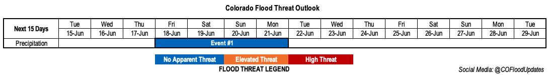
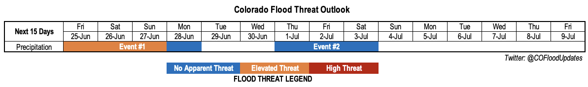
Valid Dates: 6/25-7/9

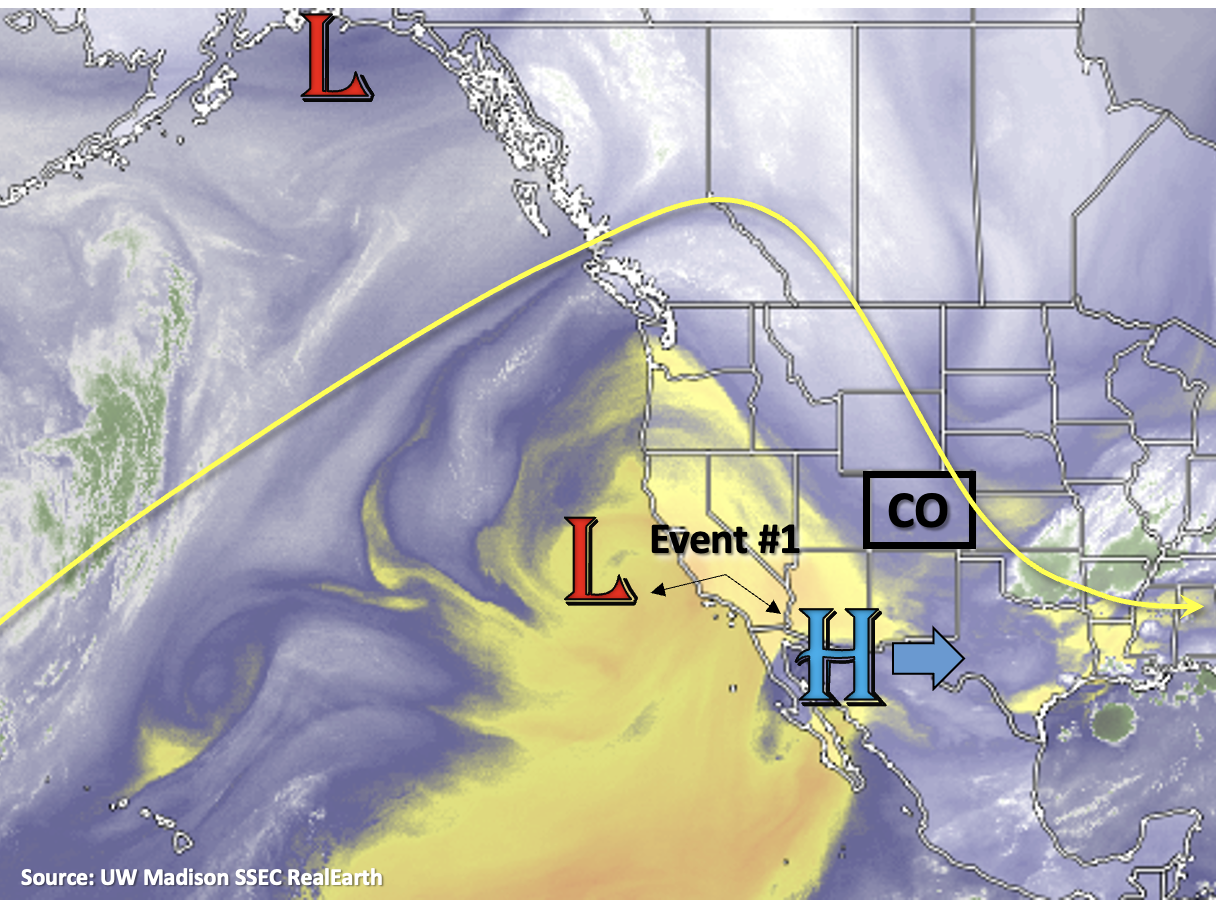
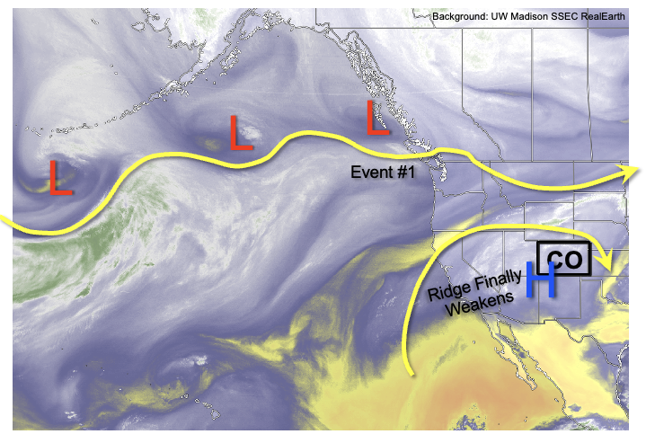
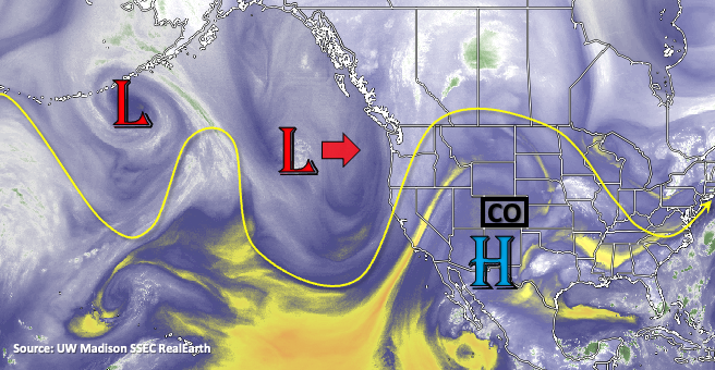
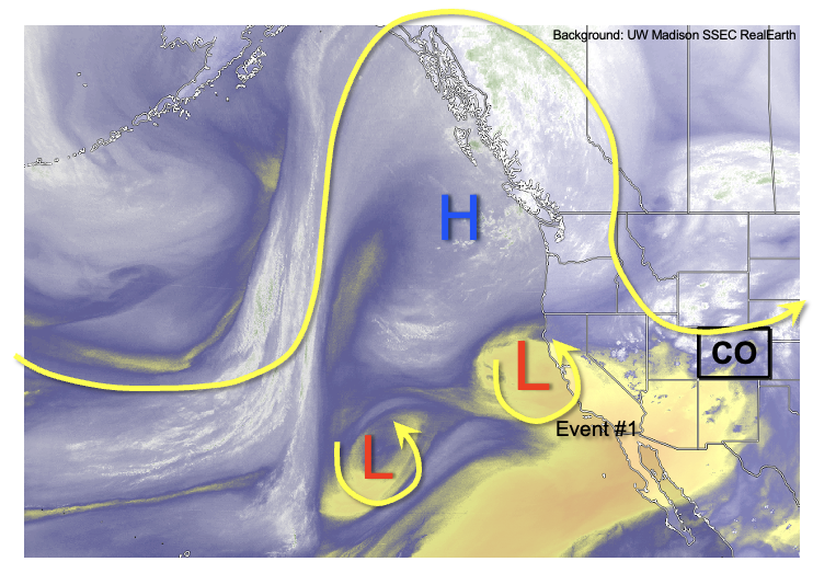
A record-breaking heat wave is expected over the Pacific Northwest this weekend and into early next week, and as shown in the water vapor image, below, the near-stationary position of this upper-level ridge will help boost Colorado’s precipitation chances. Flow of disturbances to the south of the ridge will initially provide Colorado with an Elevated flood threat through the weekend (Event #1). Thereafter, these disturbance will form a trough over the central United States, which will reinforce a generally cooler than normal pattern east of the Continental Divide and seasonable to slightly above average west of the Continental Divide. This will also lead to plenty of residual moisture trapped in the vicinity of the Four Corners, warranting the identification of Event #2. The coverage and intensity of rainfall is highly uncertain with Event #2, but it does appear that daily rounds of showers and weak storms will be likely at least over the favored higher terrain of southern and central Colorado.

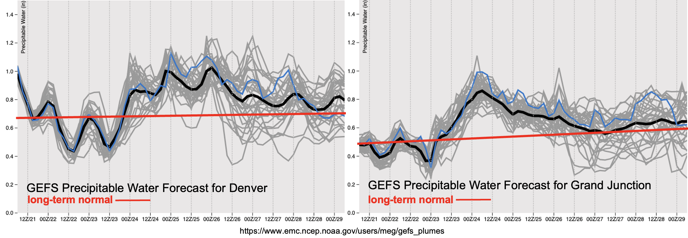
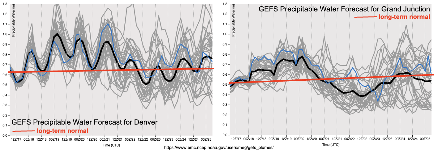
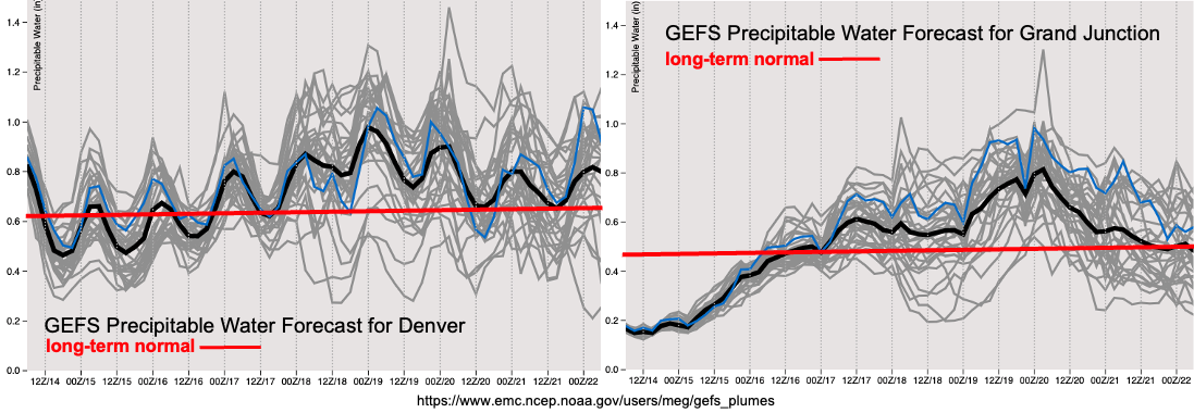
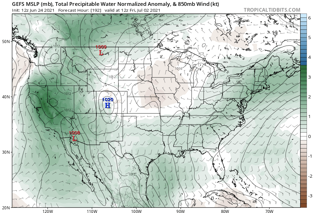
Our typical source of PW forecast plumes is unavailable today, but below is the PW anomaly forecast from the GEFS ensemble for next Friday, July 2nd. As can be seen, above normal moisture is forecasted over the entire southwest United States. Whether this will actually be converted to rainfall is a different matter, but it appears that areas in southern Colorado will have the best instability, and distance away from the Pacific Northwest ridge to see meaningful precipitation. Unfortunately, it appears that the northwest part of the state will continue to see above normal temperatures, which is not good news given the outbreak of early season wildfire activity there.

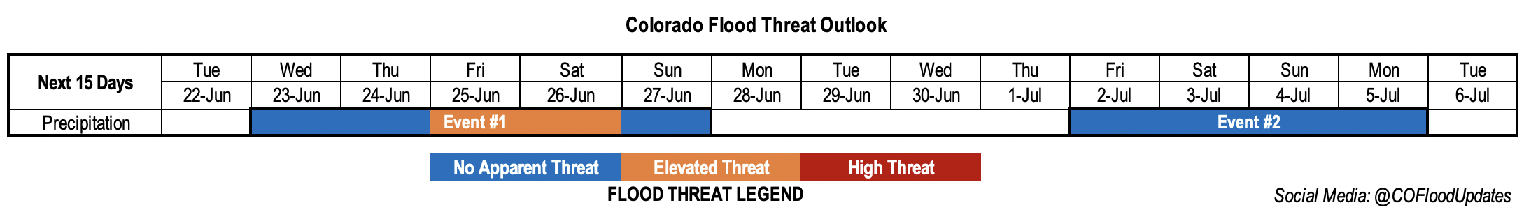
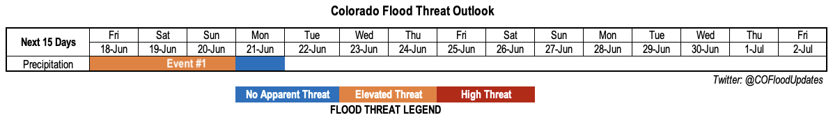
Below we describe the identified precipitation events in more detail.

Event #1: Friday – Monday (June 25 – June 28)

Elevated Flood Threat Friday-Sunday for isolated flash flooding

Numerous storms are expected nearly statewide on Friday, with the highest coverage over the central and northern high terrain in closest proximity to the upper-level disturbance. Rain rates will likely be a bit higher than today, with max 1-hour rainfall up to 1.4 inches possible west of the Continental Divide. This is enough to cause isolated flash flooding, mud flows and debris slides especially over steeper terrain. By Saturday and Sunday, activity will shift eastward and then southward as some dry air overtakes western Colorado. Scattered to numerous storms are expected along and east of the high terrain east of the Continental Divide with max 1-hour rainfall up to 1.2 inches. Eastward, over the plains, there will likely be some organized storm activity making it off the high terrain. The best chances of this will be east of the Palmer and Raton ridges, as downsloping will limit rainfall over northern Colorado. Over the plains, max 1-hour rainfall exceeding 2 inches per hour will be possible on Saturday and Sunday, given PW above 1 inch along the NE, KS and OK borders. This will be capable of producing isolated flash flooding, further supporting the Elevated flood threat for this event. On Sunday, some moisture will wrap back around southern Colorado, which will help the San Juan Mountains experience some increase in rainfall activity. However, rainfall will likely stay below 1.0 inch, which does not support flooding concerns at this time.

Event #2: Thursday – Saturday (July 1 – July 3)

No Anticipated Flood threat at this time

There is significant uncertainty as to the period following Event #1, but current guidance suggests some subtle drying before a nearly-stationary trough develops over the Central Plains. While this setup is not particularly conducive to widespread rainfall across Colorado, with plenty of residual moisture (PW > 0.8 inches at Denver and > 0.7 inches at Grand Junctions), at least scattered showers and storms are expected over the climatologically favored southern and central high terrain. At this time, we anticipate 0.5-1.0 inch of rainfall over a 3-day period and there is no anticipated flood threat. However, this could change if moisture is even higher than currently forecasted.

FTO 06-21-2021: Rainfall Chances Increase First West, Then East Thursday Into The Weekend

Issue Date: Monday, June 21st, 2021
Issue Time: 3PM MDT
Valid Dates: 6/22 – 7/6

Abnormally hot temperatures continue over the lower elevations of central and southern western Colorado, whereas northern and eastern Colorado are enjoying a nice cool down today. Movement of the High to the west and the breakdown of the anomalously strong ridge allowed a cold front to drop through Sunday evening. Stable and dry conditions behind the front will persist through Tuesday, although some weak showers may be able to develop over the Front Range and Southeast Mountains tomorrow. Some relief from the heat over western Colorado begins on Wednesday (Event #1) and rainfall chances increase at that time as well. The cutoff Low and eastward building High will combine to pull a nice plume of moisture over western Colorado on Wednesday and Thursday. Just after this, the ridge becomes dismantled by an approaching trough. This next system will push another cold front through the state on Friday, which should increase afternoon storm chances over eastern Colorado. Cooler temperatures and rainfall are forecast to continue Saturday but with more limited coverage. By Sunday, a strong High begins to build over the Pacific Northwest, which will return the dry and hot pattern to start next week.

Assessing the moisture both east and west of the Continental Divide in the PW plumes below show an uptick in moisture first west, then east. The plume over Grand Junction increases GEFS PW values about a half inch in a 24-hour period, which should be plenty of moisture for storms to develop over the mountains and elevated plateaus with the diurnal pattern and shortwave energy moving through the flow. Should this moisture be more located in the lower layers of the atmosphere, the Grizzly Creek and Pine Gulch burn will need to be monitored more closely. Dry thunderstorms and lightning are also a concern with the very dry fuels in the area (see ongoing fires over western Colorado below).

PW also increases east by Wednesday/Thursday and remains elevated through Friday. Quite a bit uncertainty in the PW forecast after Friday, but by the end of the weekend the dome of high pressure will aid in returning PW to more seasonable values statewide. An brief Elevated flood threat has been issued for Event #1 for eastern Colorado (Friday) and southeastern Colorado (Saturday).

Still a lot of uncertainty with Event #2, but it is worth mentioning the possible increase in storminess over the 4th of July holiday weekend. More northerly flow is forecast as the High builds across the western US. Won’t mention more than this for now, but rainfall chances generally increase with this pattern as systems more easily move through flow. Tune back into the FTO on Thursday for the latest update.

Ongoing Wildfires

It has been dry, windy and hot out west over the last week or two. This has unfortunately started some new fires, including one in the last 24-hours. The Sylvan fire is currently burning 12 miles south of Eagle, which started yesterday afternoon. So far, it has burned 400 acres and Sylvan Lake State Park remains closed. Also burning in southwest Rio Blanco County is the Oil Springs Fire. This fire began from lightning on June 18th, and there has been significant growth today with wind gusts and dry fuels. Lastly, the Trail Canyon fire is burning 10 miles NW of Red Mesa in western Montezuma County (started June 19th from lightning). Firefighters have been able to hold their ground on this burn despite some very strong winds yesterday afternoon. Lightning paired with the dry fuels is a concern from storms that will develop Wednesday/Thursday over the area.

Event #1: WednesdaySunday (6/23 – 6/27)

Brief, low-end Elevated flood threat for eastern Colorado as the next system drops a cold front through on Friday.

Rainfall chances over the western mountains is forecast to increase Wednesday into Thursday. The biggest unknown right now is how much of this moisture will be located in the lower layers of the atmosphere, which will influence the efficiency of the rain to reach the surface. Gusty outflow winds and lightning will be the main threats from storms as of right now. Over eastern Colorado, depending on when the front moves through on Friday, some low-end severe weather and brief, local heavy rainfall may be possible over the mountains and adjacent plains. This includes recent burn areas along the Front Range if a good upslope component can develop. Best chance for the heavier rainfall producers will be over the elevated ridges and eastern plains. However, increased steering flow and only minimal CAPE should help to keep the flood threat from being widespread and on the low-end of the threat scale. On Saturday, moisture behind the front and increased instability may also help to spark some heavy rainfall producers and severe weather across the Raton Ridge and Southeast Plains. Outside of some storms over the Southeastern Mountains on Sunday, it should begin to dry out and warm up under the dome of high pressure.

FTO 06-17-2021: Elevated Flood Threat Early Leads To Big Cool-down, Then Return To Heat Possible

Issue Date: Thursday, June 17th, 2021
Issue Time: 1:45PM MDT
Valid Dates: 6/18-7/2

The recent record-breaking heat wave is finally in its waning stage today, so it is prudent to take a brief look at just how impressive it was. Shown below is the June month-to-date temperature departure from normal. Amazingly, a small part of the Southeast Plains continues to have below normal June average temperature. However, for everyone else, especially west of the Continental Divide, anomalies up to 8F are seen. In terms of specifics, one of the most impressive aspect of the heat wave was how early in the season extreme heat was observed. For example, Grand Junction’s high temperature of 105F on June 16th occurred a full 11 days earlier than any previous instance of such heat. This is particularly noteworthy given that Grand Junction records date back to 1893.

As shown in the water vapor image, below, a major change in the pattern is in store for Colorado. The upper-level ridge responsible for the heat wave will rapidly weaken later today, and be gradually replaced by a transient but strong upper-level trough over the US Midwest by Sunday. This will drive a very strong cold front across Colorado, especially noticeable east of the Continental Divide where temperatures will fall to 15F or more below normal by Monday. In the days leading up to the cool front passage, shortwave disturbances in the evolving westerly flow will have some success sparking scattered to locally widespread shower and thunderstorm activity (Event #1).

The forecast PW plumes, below, show that elevated moisture will persist across most of the state through Sunday, after which significant drying will take place with the aforementioned cold front passage. The main obstacle to heavy rainfall generation with Event #1 will be marginal boundary layer moisture and the residual presence of a stout “cap” above the boundary layer that will tend to suppress storm development especially for lower elevations. Nonetheless, we expect daily rounds of showers and storms mainly across the central and southern high terrain. Sufficient moisture there, along with moderately deep upslope flow warrants an Elevated Flood Threat for Event #1. Away from higher terrain, there is significant uncertainty as to the presence and duration of thunderstorm activity. Currently, it appears the best chances of lower elevation heavy rainfall will be along and east of the Raton and Palmer ridges.

After the cold front passage on Monday, we expect a gradual recovery of temperatures to seasonal or above seasonal normal. Unfortunately, this is looking especially likely west of the Continental Divide, which is not good news given the ongoing drought over that part of the state. East of the Continental Divide, there is some suggestion of more precipitation by later next week as the Midwest US trough could re-strengthen, which would also cool temperatures to seasonal normal or below. However, the uncertainty is too great to identify an organized precipitation event at this time.

Below we describe Event #1 in more detail.

Event #1: Friday – Monday (June 18 – June 21)

Low-end Elevated Flood Threat Friday-Sunday, followed by steadier, lighter rainfall on Monday

Daily rounds of afternoon and evening showers and thunderstorms are likely over the San Juan Mountains, Central Mountains, Southeast Mountains, Raton Ridge and Palmer Ridge. Maximum 1-hour rainfall up to 1.1 inches will be possible, which supports a low-end Elevated Flood Threat for isolated flash flooding, debris slides and mud flows over the 1-2 hour duration period. Storm coverage looks to be lower for the Front Range and Urban Corridor due to more downsloping flow, although there is some uncertainty here. Farther east, it appears the Southeast Plains stand the best chance of seeing organized storms that move off the higher terrain. Maximum 1-hour rainfall above 1.5 inches will occur if enough instability exists. However, the exact placement of this is currently very uncertain so stay tuned to daily Flood Threat Bulletins for updated information. By Monday, almost all instability will be absent, with the possible exception in parts of the Southeast Mountains and San Juan Mountains. Thus, lighter but steadier rainfall may occur as the cold front moves across the state.

Unfortunately, it appears that chances of measurable precipitation in lower elevations west of the Continental Divide do not look good, although the increase in humidity will certainly greatly help in mitigating the ongoing wildfire threat.

FTO 06-14-2021: Record Breaking Heat Continues with Storms Likely Returning by the Weekend

Issue Date: Monday, June 14th, 2021
Issue Time: 2PM MDT
Valid Dates: 6/15 – 6/29

The main story this week will be the continuation of the early season heat wave as the ridge begins to strengthen over the next couple of days. Record heat was logged across many of the lower elevation areas out west on Sunday. More records may even be broken again with the 594mb line moving northwards over the next couple of days. The 102F recorded at the Grand Junction WFO yesterday moved into the top 10 hottest 1-day maximum temperature (rank: 8). We’ll be keeping an eye on record heat streaks for that area the next couple of days, too. Generally speaking, there’s a good chance that many locations across all of Colorado, below 5,500 feet, will cross the century mark (100F). We’re still not quite as hot as June 2012 (statewide), which is our warmest on record.

It will remain nearly dry over the next couple of days. This lull in precipitation during mid to late June is fairly typical before we transition over to the monsoon pattern. Residual moisture under the ridge may spark some weak afternoon convection over and near the mountains, but not much rainfall is anticipated. The ridge becomes flattened heading into next weekend by the approaching Low. The GEFS is hinting at higher moisture behind a weak cold front on Friday, while the EPS indicates less. Both imply enough moisture to return PM storm chances to the mountains (south and east). At this time there is No Apparent flood threat. The better chance for more severe storms and storm spill over into the eastern plains will likely be on Friday with the extra dynamics in place.

Taking a look at the May Colorado reservoir storage below, there’s nothing too surprising. As anticipated with the high snowpack, the South Platte storage is up to over 100%. The Arkansas storage also increased some when compared to April. This is a very typical pattern with snow melt increasing at this time of year. The largest deficient from April looks to be over the Gunnison basin where storage is about 70% of normal. Statewide, Colorado is slightly above 80% of average, which is lower than this time last year. With the much drier weather during June, especially out west, it will be interesting to see the storage reservoirs at the beginning of July.

Event #1: FridayMonday (6/18 – 6/21)

No Apparent flood threat as upslope driven storms return behind a cold front.

The biggest question about the next system will be how large the moisture return is behind the very welcomed cold front. Predicting moisture plumes this far out is a bit tough. Nonetheless, rainfall chances increase across the southern terrains, favoring the eastern mountains heading into this next weekend. It does look like storms will return to the San Juan Mountains as well with measurable rainfall likely both Friday and Sunday. Spill over storms into the adjacent eastern plains (south) is most likely on Friday and Saturday with a higher potential severe threat on Friday. So, Friday is the anticipated peak in activity, but at this time, there is No Apparent flood threat.