Issue Date: Thursday, June 17th, 2021
Issue Time: 1:45PM MDT
Valid Dates: 6/18-7/2
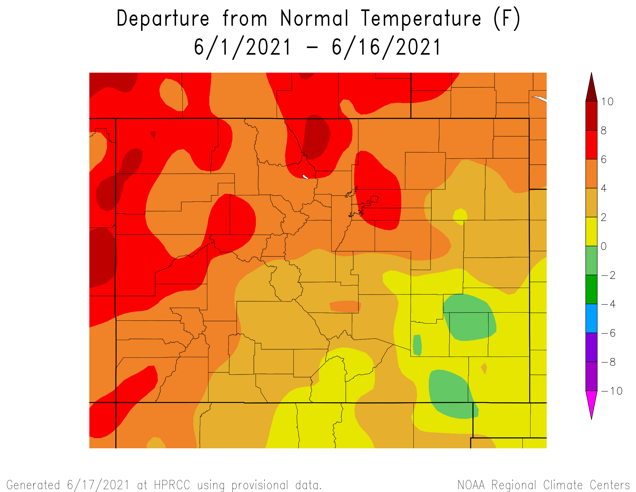
The recent record-breaking heat wave is finally in its waning stage today, so it is prudent to take a brief look at just how impressive it was. Shown below is the June month-to-date temperature departure from normal. Amazingly, a small part of the Southeast Plains continues to have below normal June average temperature. However, for everyone else, especially west of the Continental Divide, anomalies up to 8F are seen. In terms of specifics, one of the most impressive aspect of the heat wave was how early in the season extreme heat was observed. For example, Grand Junction’s high temperature of 105F on June 16th occurred a full 11 days earlier than any previous instance of such heat. This is particularly noteworthy given that Grand Junction records date back to 1893.
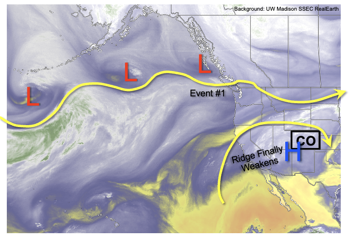
As shown in the water vapor image, below, a major change in the pattern is in store for Colorado. The upper-level ridge responsible for the heat wave will rapidly weaken later today, and be gradually replaced by a transient but strong upper-level trough over the US Midwest by Sunday. This will drive a very strong cold front across Colorado, especially noticeable east of the Continental Divide where temperatures will fall to 15F or more below normal by Monday. In the days leading up to the cool front passage, shortwave disturbances in the evolving westerly flow will have some success sparking scattered to locally widespread shower and thunderstorm activity (Event #1).
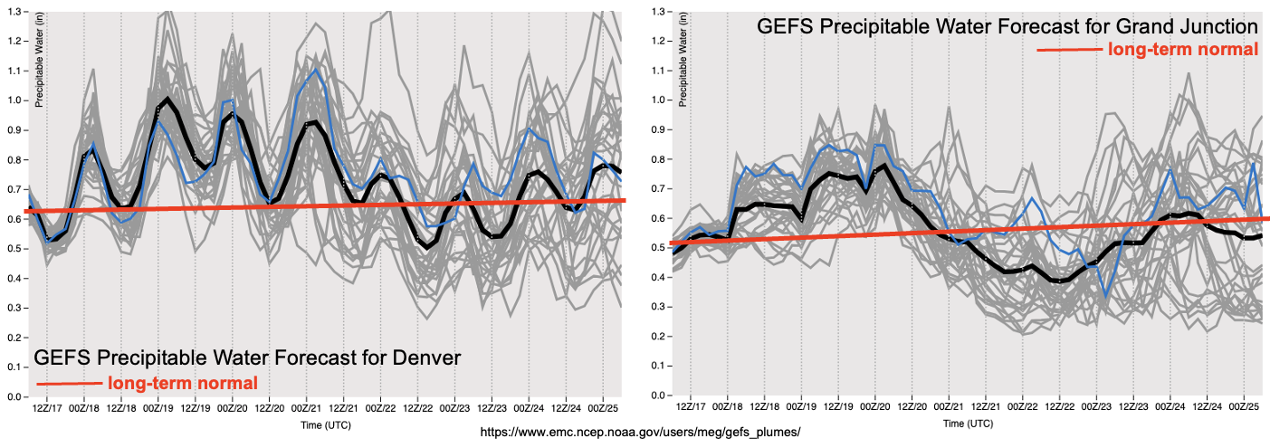
The forecast PW plumes, below, show that elevated moisture will persist across most of the state through Sunday, after which significant drying will take place with the aforementioned cold front passage. The main obstacle to heavy rainfall generation with Event #1 will be marginal boundary layer moisture and the residual presence of a stout “cap” above the boundary layer that will tend to suppress storm development especially for lower elevations. Nonetheless, we expect daily rounds of showers and storms mainly across the central and southern high terrain. Sufficient moisture there, along with moderately deep upslope flow warrants an Elevated Flood Threat for Event #1. Away from higher terrain, there is significant uncertainty as to the presence and duration of thunderstorm activity. Currently, it appears the best chances of lower elevation heavy rainfall will be along and east of the Raton and Palmer ridges.
After the cold front passage on Monday, we expect a gradual recovery of temperatures to seasonal or above seasonal normal. Unfortunately, this is looking especially likely west of the Continental Divide, which is not good news given the ongoing drought over that part of the state. East of the Continental Divide, there is some suggestion of more precipitation by later next week as the Midwest US trough could re-strengthen, which would also cool temperatures to seasonal normal or below. However, the uncertainty is too great to identify an organized precipitation event at this time.
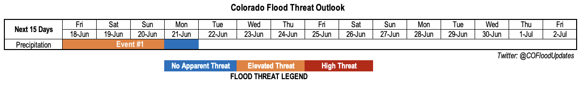
Below we describe Event #1 in more detail.
Event #1: Friday – Monday (June 18 – June 21)
Low-end Elevated Flood Threat Friday-Sunday, followed by steadier, lighter rainfall on Monday
Daily rounds of afternoon and evening showers and thunderstorms are likely over the San Juan Mountains, Central Mountains, Southeast Mountains, Raton Ridge and Palmer Ridge. Maximum 1-hour rainfall up to 1.1 inches will be possible, which supports a low-end Elevated Flood Threat for isolated flash flooding, debris slides and mud flows over the 1-2 hour duration period. Storm coverage looks to be lower for the Front Range and Urban Corridor due to more downsloping flow, although there is some uncertainty here. Farther east, it appears the Southeast Plains stand the best chance of seeing organized storms that move off the higher terrain. Maximum 1-hour rainfall above 1.5 inches will occur if enough instability exists. However, the exact placement of this is currently very uncertain so stay tuned to daily Flood Threat Bulletins for updated information. By Monday, almost all instability will be absent, with the possible exception in parts of the Southeast Mountains and San Juan Mountains. Thus, lighter but steadier rainfall may occur as the cold front moves across the state.
Unfortunately, it appears that chances of measurable precipitation in lower elevations west of the Continental Divide do not look good, although the increase in humidity will certainly greatly help in mitigating the ongoing wildfire threat.