Issue Date: Monday, June 21st, 2021
Issue Time: 3PM MDT
Valid Dates: 6/22 – 7/6
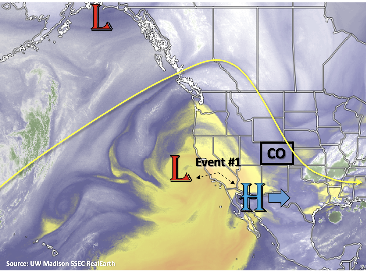
Abnormally hot temperatures continue over the lower elevations of central and southern western Colorado, whereas northern and eastern Colorado are enjoying a nice cool down today. Movement of the High to the west and the breakdown of the anomalously strong ridge allowed a cold front to drop through Sunday evening. Stable and dry conditions behind the front will persist through Tuesday, although some weak showers may be able to develop over the Front Range and Southeast Mountains tomorrow. Some relief from the heat over western Colorado begins on Wednesday (Event #1) and rainfall chances increase at that time as well. The cutoff Low and eastward building High will combine to pull a nice plume of moisture over western Colorado on Wednesday and Thursday. Just after this, the ridge becomes dismantled by an approaching trough. This next system will push another cold front through the state on Friday, which should increase afternoon storm chances over eastern Colorado. Cooler temperatures and rainfall are forecast to continue Saturday but with more limited coverage. By Sunday, a strong High begins to build over the Pacific Northwest, which will return the dry and hot pattern to start next week.
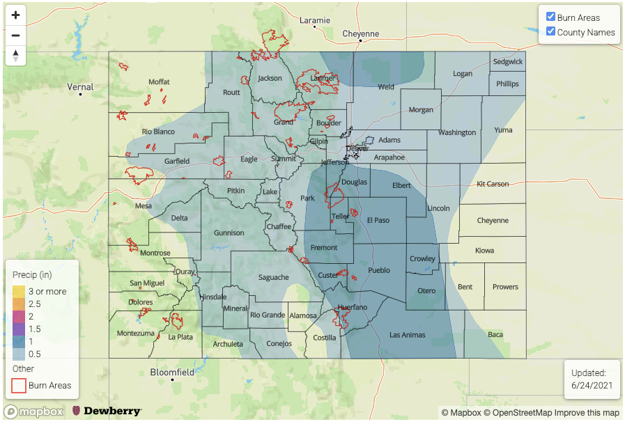
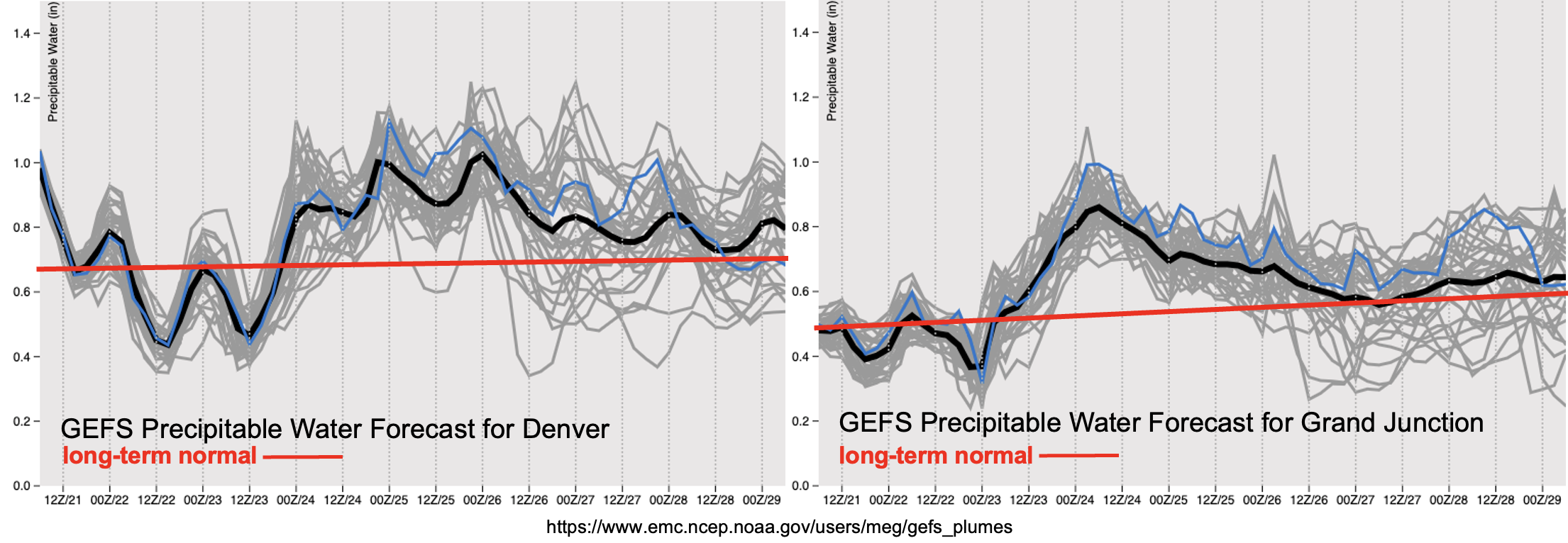
Assessing the moisture both east and west of the Continental Divide in the PW plumes below show an uptick in moisture first west, then east. The plume over Grand Junction increases GEFS PW values about a half inch in a 24-hour period, which should be plenty of moisture for storms to develop over the mountains and elevated plateaus with the diurnal pattern and shortwave energy moving through the flow. Should this moisture be more located in the lower layers of the atmosphere, the Grizzly Creek and Pine Gulch burn will need to be monitored more closely. Dry thunderstorms and lightning are also a concern with the very dry fuels in the area (see ongoing fires over western Colorado below).
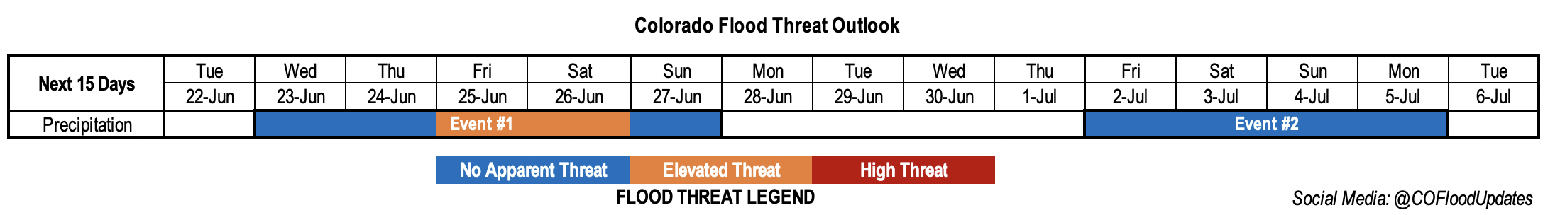
PW also increases east by Wednesday/Thursday and remains elevated through Friday. Quite a bit uncertainty in the PW forecast after Friday, but by the end of the weekend the dome of high pressure will aid in returning PW to more seasonable values statewide. An brief Elevated flood threat has been issued for Event #1 for eastern Colorado (Friday) and southeastern Colorado (Saturday).
Still a lot of uncertainty with Event #2, but it is worth mentioning the possible increase in storminess over the 4th of July holiday weekend. More northerly flow is forecast as the High builds across the western US. Won’t mention more than this for now, but rainfall chances generally increase with this pattern as systems more easily move through flow. Tune back into the FTO on Thursday for the latest update.
Ongoing Wildfires
It has been dry, windy and hot out west over the last week or two. This has unfortunately started some new fires, including one in the last 24-hours. The Sylvan fire is currently burning 12 miles south of Eagle, which started yesterday afternoon. So far, it has burned 400 acres and Sylvan Lake State Park remains closed. Also burning in southwest Rio Blanco County is the Oil Springs Fire. This fire began from lightning on June 18th, and there has been significant growth today with wind gusts and dry fuels. Lastly, the Trail Canyon fire is burning 10 miles NW of Red Mesa in western Montezuma County (started June 19th from lightning). Firefighters have been able to hold their ground on this burn despite some very strong winds yesterday afternoon. Lightning paired with the dry fuels is a concern from storms that will develop Wednesday/Thursday over the area.
Event #1: Wednesday – Sunday (6/23 – 6/27)
Brief, low-end Elevated flood threat for eastern Colorado as the next system drops a cold front through on Friday.
Rainfall chances over the western mountains is forecast to increase Wednesday into Thursday. The biggest unknown right now is how much of this moisture will be located in the lower layers of the atmosphere, which will influence the efficiency of the rain to reach the surface. Gusty outflow winds and lightning will be the main threats from storms as of right now. Over eastern Colorado, depending on when the front moves through on Friday, some low-end severe weather and brief, local heavy rainfall may be possible over the mountains and adjacent plains. This includes recent burn areas along the Front Range if a good upslope component can develop. Best chance for the heavier rainfall producers will be over the elevated ridges and eastern plains. However, increased steering flow and only minimal CAPE should help to keep the flood threat from being widespread and on the low-end of the threat scale. On Saturday, moisture behind the front and increased instability may also help to spark some heavy rainfall producers and severe weather across the Raton Ridge and Southeast Plains. Outside of some storms over the Southeastern Mountains on Sunday, it should begin to dry out and warm up under the dome of high pressure.