FTO 07-22-2021: Very Active Monsoon Continues; Dry Heat To Build East Of Continental Divide

Issue Date: Thursday, July 22nd, 2021
Issue Time: 12:35PM MDT
Valid Dates: 7/23-8/6

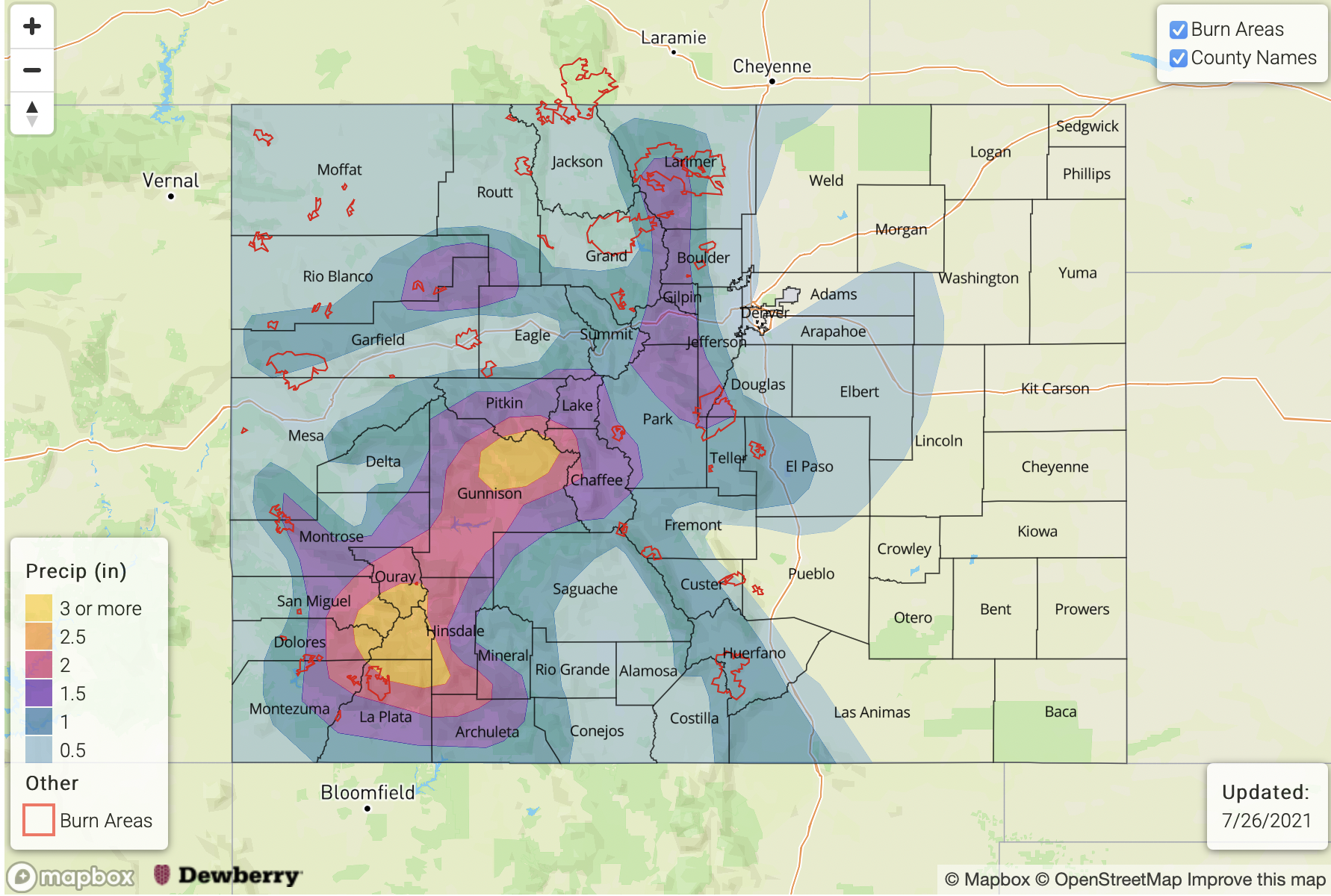
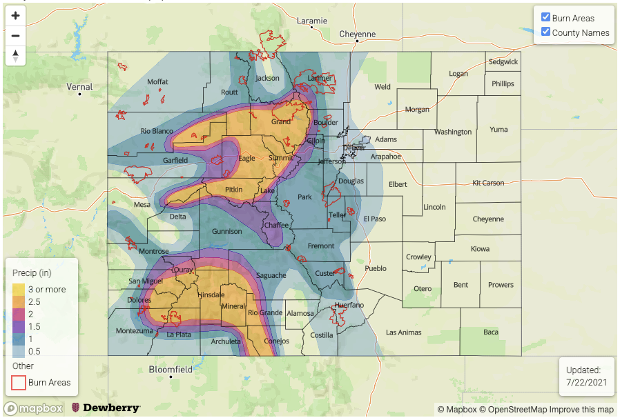
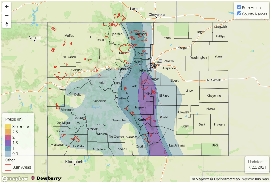
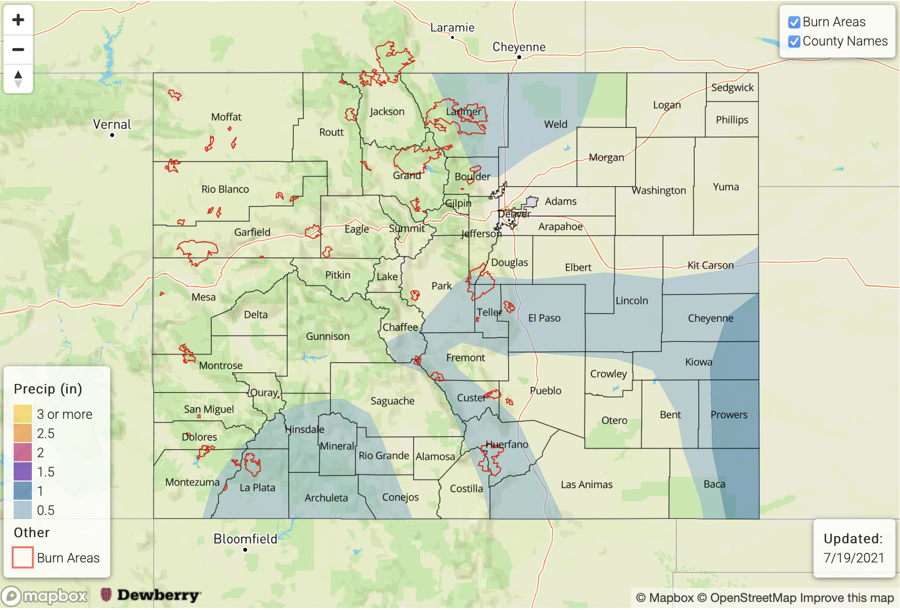
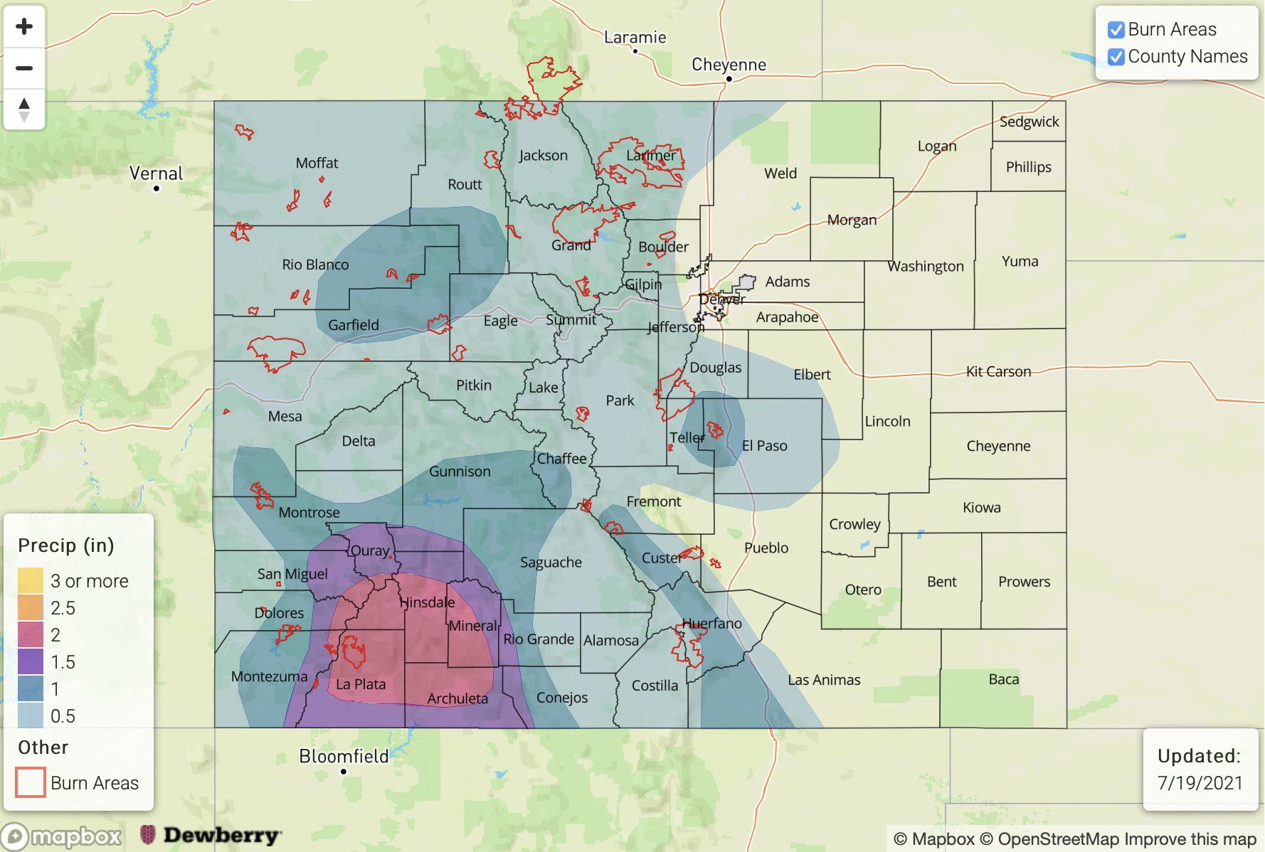
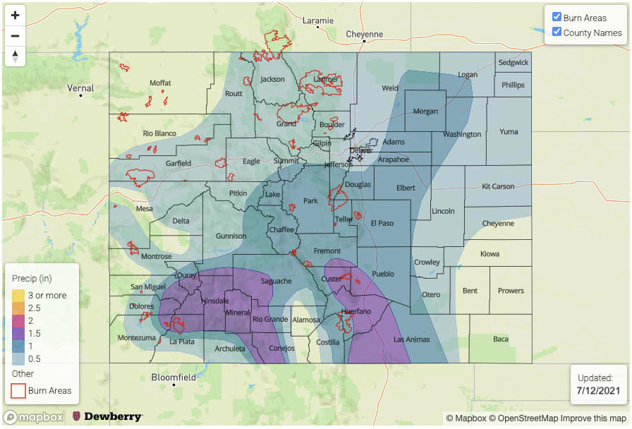
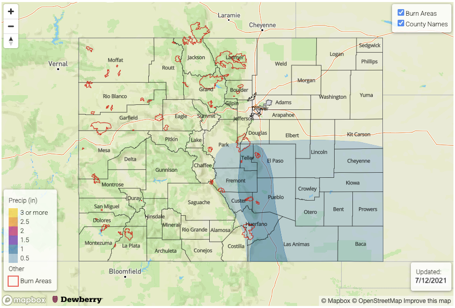
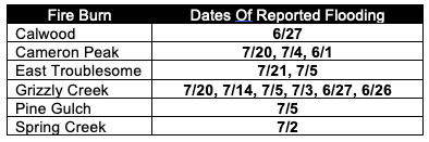
After a few recent monsoon seasons turned out to be “duds”, most notably 2020, 2021 is reminding is just how persistent higher terrain storm activity can be when enough monsoon moisture is present. As we repeat many times within our discussions, our unique topography can drive its own atmospheric circulation that generates storms activity. Although the monsoon can produce dangerous flooding anywhere, it is particularly troubling for fresh burn scar areas. The table below shows that, at this point, each of our six “major” burn scars that we track daily, has experienced flooding during 2021. Of the 14 separate events (note that some of the days actually had multiple separate runoff events), 13 of the 14 have occurred during the monsoon season. That is the bad news.

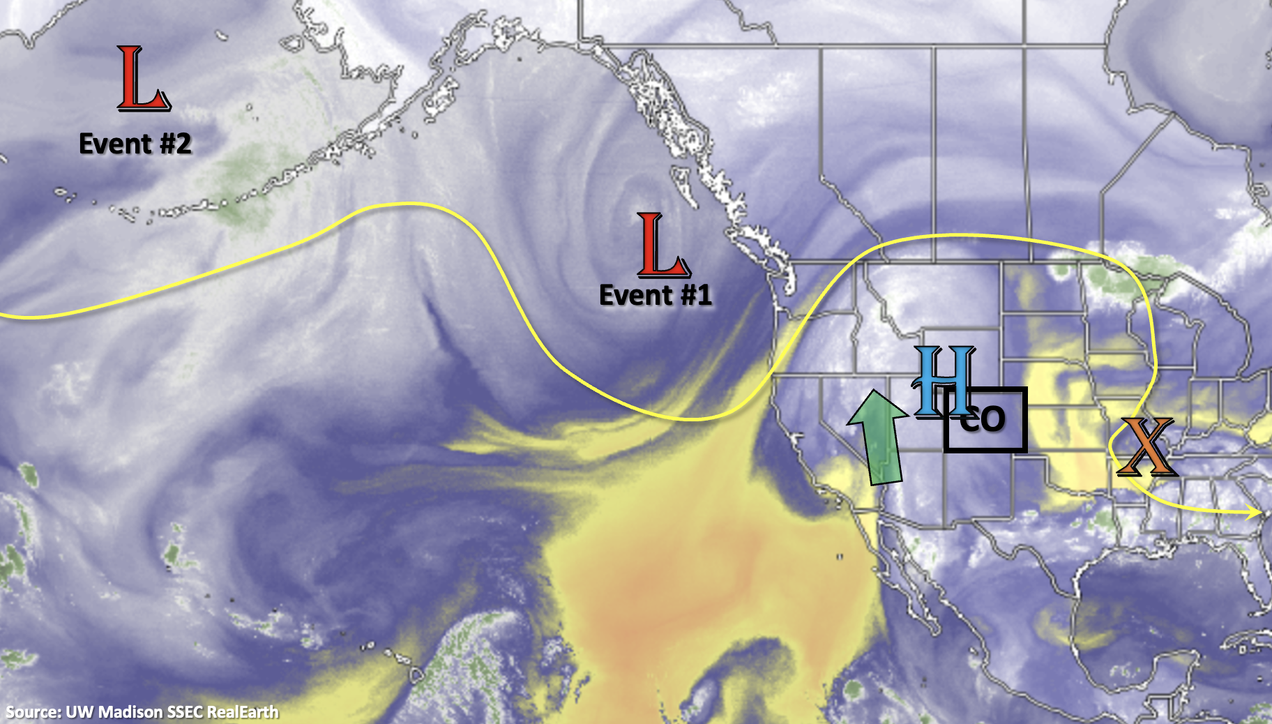
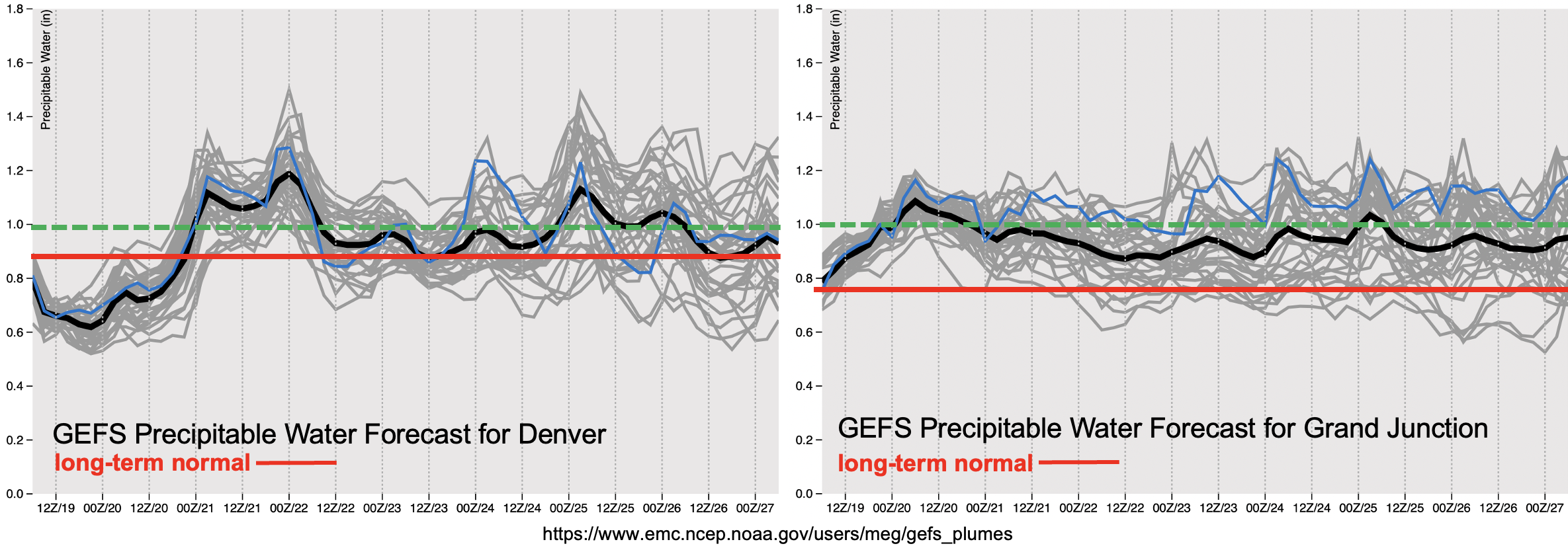
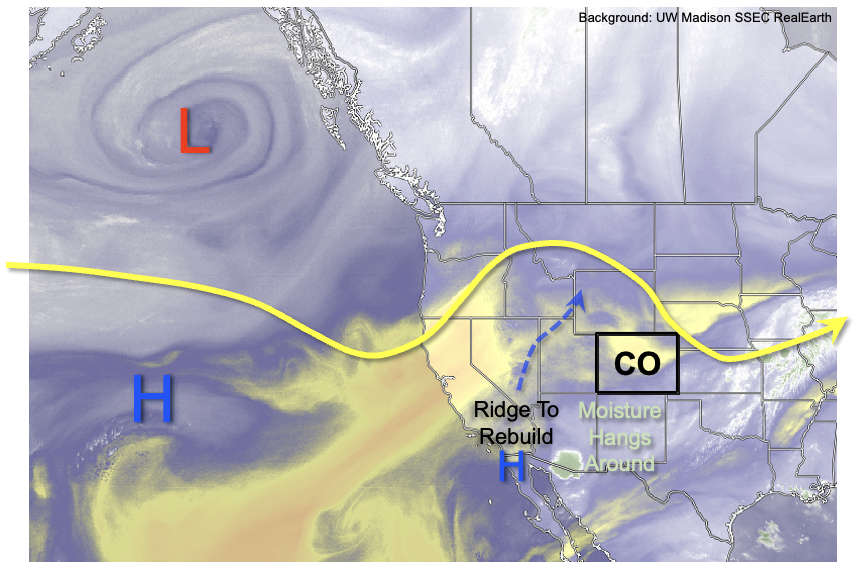
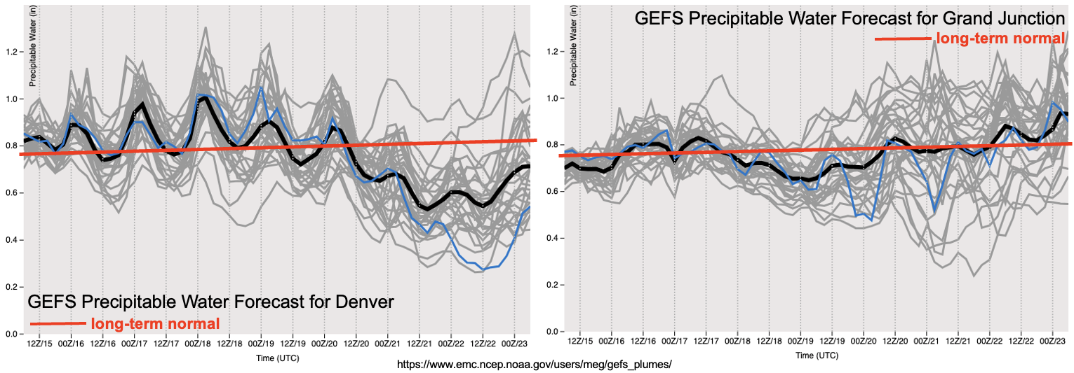
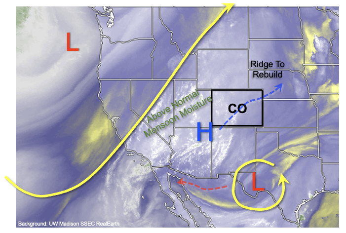
The good news is that new wildfire activity will be prevented as long as soil moisture is replenished with measurable rainfall every so often. Fortunately, as shown in the water vapor image, below, during the next 10 days, perhaps longer, we expect a very active monsoon to continue across the Four Corners and into western Colorado. West of the Continental Divide, PW is expected to remain 20-50% above normal as residual monsoon moisture moves around the region. Additionally, the ridge aloft that has been centered very close to Colorado in the recent days will re-emerge to the northeast/east of us and strengthen. One important ramification of this will be an increase in temperatures especially east of the Continental Divide where downsloping winds will produce 100F+ heat at lower elevations below 5,000 feet. However, the more relevant impact of such a ridge position will be to keep advecting fresh monsoon moisture from its “source” region of the highlands of western Mexico and the Gulf of California.

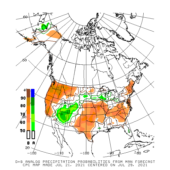
The map below from the Climate Prediction Center shows the composite anomalous precipitation (% of normal) that occurred on the top 10 matching days with the upper-level ridge over the Central Plains, as is being forecasted. Interestingly, despite general below normal precipitation over the western United States, the monsoon region stands out quite drastically with a 70% or greater chance of seeing above normal precipitation. Keep in mind that this analysis relies on heavily smoothed precipitation grids, implying an even greater chance of seeing above normal precipitation over the preferred regions of the San Juans, Central and Northern Mountains over the next 10 days or so. Thereafter, uncertainty increases as guidance suggests the ridge will move closer to Colorado, which would tend to promote some drying. However, it remains to be seen whether this occurs, since it will take some time to scour out so much moisture.

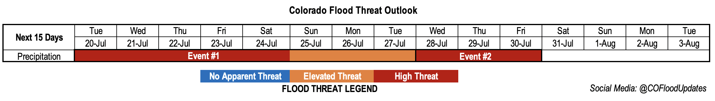
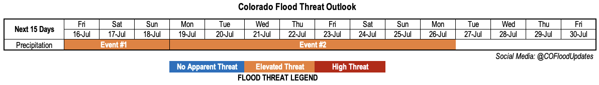
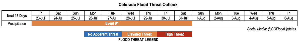
For this Outlook, we have identified a single, but prolonged precipitation Event, described in more detail below.

Event #1: Friday – Saturday (July 23 – July 31)

Persistent Elevated Flood Threat For Higher Terrain

Although plenty of day-to-day variability is expected in terms of the exact positioning and peak intensity of heavy rainfall, we expect daily showers and thunderstorms to cover the high terrain over this period. In terms of rainfall intensity, 1 inch per hour or greater intensity appears very likely daily with even higher storm total amounts. However, during particularly active days, up to 2 inches per hour of rainfall could occur. The preferred areas will be entire higher terrain, with the exception of the Southeast Mountains that will be more susceptible to subsidence and intrusions of drier air from the east.

In all, we expect that widespread locations in the higher terrain will experience at least 2 inches of rainfall over the course of this event, with isolated locations likely exceeding 3 inches. Even higher totals will be possible depending on the favorability of setups that cannot be determined with this kind of lead time. In terms of impacts, isolated flash flooding, mud flows and debris slides will be likely throughout the Event. However, smaller basins such as creeks and tributaries will also be susceptible to riverine flooding given that repeated days with precipitation will increase base flows.

Please check in on daily Flood Threat Bulletins for the latest updates, and pay attention to National Weather Service products for real-time warnings and advisories.

FTO 07-19-2021: A High Flood Threat is Issued with the Majority of Rainfall Forecast Over Western Colorado

Issue Date: Monday, July 19th, 2021
Issue Time: 2:40PM MDT
Valid Dates: 7/20 – 8/3

We’re well into the heart of the monsoon season now, and it has been a busy one with an early onset. Another active FTO is forecast with the nearly stationary upper-level High/Low pattern allowing for an impressive, long-lasting moisture surge over the western US into next week (Event #1). For the most part, Event #1 will affect the western portion of the state, but storm coverage is expected to increase over the eastern mountains by this weekend. In addition to the heightened moisture, there is plenty of mid-level energy forecast to move through the flow. These pockets of lift, especially when timed with peak heating, can help to expand the heavy rainfall coverage and intensity. Tracking these subtle shortwaves in the daily FTB will likely be the key to determining the heavy rainfall threat and location each day. This is especially true because there’s a chance for ongoing cloud cover with this persistent rainfall pattern, which may inhibit the amount of instability that can build.

Below the PW plumes from the GEFS (below) show how impressive this surge of moisture really is in the context of climatology (red line). Keep in mind that this forecast period is at the height of PW in terms of climatology. PW values (black line), both east and west, are forecast to remain above climatology throughout Event #1. The green dashed line below shows the 1 inch PW value, which is a good proxy for the heavy rainfall threat. Even with the slight lull in PW Thursday and Friday, PW still remains above the long-term normal. For this reason, a High flood threat has been issued.

There isn’t a break before Event #2 begins mid-next week as it is, more or less, a shift of the plume eastward. At this time, it looks like moisture will remain well-above climatology with a similar High/Low pattern setting up. The one difference is that it looks like the heavy rainfall threat will shift into the high terrains east of the Continental Divide with subtle movement of the ridge axis. A High threat has been issued for Event #2.

Keep scrolling below to read more details about each of the events.

Event #1: Tuesday – Tuesday (7/20 – 7/27)

High/Elevated flood threat as a High/Low pattern holds a strong moisture plume in place over the next week.

It’s going to be rainy the next week over western Colorado, which will be welcomed by most. However, with a strong moisture plume intact, the threat for heavy rainfall increases. Highest totals are expected to over the climatologically favored San Juan and Central Mountains. This includes the elevated plateaus of the Grand Valley, Northwest Slope and Southwest Slope. One limiting factor to the heavy rainfall threat may be ongoing cloud cover, which could inhibit instability from developing and slightly lower rainfall rates. Still, even the moderate intensity storms that develop, will be capable of producing higher rainfall rates than normal with the nearly saturated environment. A peak in intensity and coverage of storms is forecast on Wednesday. Threats over steeper terrains for this event include mud flows, debris slides and excessive runoff. These threats are expected to increase after a couple days of rainfall begins to saturate the soils. Recent burn areas, especially Grizzly Creek, will be susceptible (on and off) to flooding through next week. Be sure to tune into the FTB for the latest each morning as the potential heavy rainfall threat can be better pinpointed.

Event #2: WednesdayFriday (7/28 – 7/30)

Slight shift in the ridge axis shifts threat east, but moisture remains above average, so a High flood threat is issued.

Not much of a break as the above average moisture rotates into eastern Colorado mid-next week. As far as the location of the heavy rainfall, went ahead with climatology for this event. Slower steering flows with the High overhead should keep most of the storms over the mountains, although there may be some spill over into the immediate adjacent plains and ridges. Be sure to tune back into the FTO on Thursday for the latest on this developing event.

FTO 07-15-2021: Persistent Elevated Flood Threat, Mainly West of Continental Divide, As Monsoon Moisture Hangs Around

Issue Date: Thursday, July 15th, 2021
Issue Time: 12PM MDT
Valid Dates: 7/16-7/30

If we rewind back to mid-June, after an intense, record breaking early summer heat wave plagued the state, there was significant concern of another off the charts wildfire season given the dry vegetation. Now just one month later, we are seeing a fortunate reversal of events, at least for Colorado, as above normal monsoon moisture is expected to hang around the state indefinitely. The maps below compare the ongoing “Large Incidents” wildfire activity from the US Forest Service with 30-day precipitation departures (% of normal). A strong correlation is seen across the western US with wildfires occurring where little to no precipitation has fallen since summer started. Some deviation is seen in central Arizona, but this is likely because most of the precipitation has occurred recently so wildfires have not been entirely suppressed yet.

Looking at this morning’s water vapor image, one will notice that we have not zoomed out as much as normal. This is because most of the important atmospheric features for this Outlook will be “circling around” the Four Corners for the next 10-15 days. The key feature to watch will be the placement and intensity of the so-called “Monsoon Ridge”, which is currently in latency over southwest AZ. This feature will quickly intensify and move N/NE to hold a position north of Colorado within 72 hours. Thereafter, this ridge is expected to maintain near-stationarity for the duration of this Outlook. With the position of the ridge to our north, this will allow for the transport of moisture and disturbances from the east, a fairly unusual occurrence for us. And with plenty of moisture available over NM and AZ to transport northward, we expect a rather active pattern for the daily occurrence of scattered heavy rainfall mainly focused over the climatologically favored parts of western and southwestern Colorado.

As seen in the forecasted Precipitable Water plumes for Denver and Grand Junction, above normal moisture will hang around most of the state over the next 72 hours. Thereafter, some drying will occur east of the Continental Divide as a cut-off low pressure is forecasted to move into the southern Great Plains. Subsidence and some dry air transport will reduce moisture over northeast Colorado. However, above normal moisture will persist west of the Continental Divide, especially over the southwest parts of the state leading to thunderstorm activity capable of generating heavy rainfall and flooding.

For this Outlook, we have identified two precipitation events, which are described in more detail below.

Event #1: Friday – Sunday (July 16 – July 18)

Low-end Elevated Flood Threat for eastern Plains as well as central and southern high terrain

There is significant uncertainty with this event, especially given the short lead time. However, the passage of a disturbance is expected to yield scattered to possibly numerous shower and thunderstorms activity on Friday. Higher elevations of the Northern, Central and San Juan Mountains are expected to see isolated heavy rainfall up to 1.0 inch per hour. Farther east, there is an increasing likelihood of organized clusters of storms moving off the high terrain and into the lower elevations. Rain rates over the lower elevations are uncertain, but enough moisture is available to sustain 1.5 inches/hour or more, which would support isolated flash flooding. Severe weather, both strong winds and hail, are also possible with the stronger storms towards the NE and KS borders. By Saturday and Sunday, most activity over the Plains is expected to subside, but scattered storms should continue over the central and southern high terrain, capable of producing 1.0 inch per hour of rainfall.

Event #2: Monday – Monday (July 19 – July 26)

Persistent Elevated Flood Threat over southwest Colorado

An increase in monsoon-origin moisture is expected to enter southwest Colorado beginning Monday, leading to an increase in the northward extent of thunderstorm coverage. Unfortunately, it is currently difficult to pinpoint which days will be most threatening, which will be hashed out in daily Flood Threat Bulletins. However, at least scattered storm activity is expected every day over the next week, and it is very likely that several days will likely have particularly high potential to produce heavy rainfall. Maximum 1-hour intensity locally exceeding 1.0 inch looks like a very good bet nearly every day with this event. While over this 8-day period covered by this Event, we foresee up to 2.5 inches of total precipitation over the San Juan Mountains with lower totals in surrounding areas. At this time, there is significant uncertainty as to how much rainfall will occur in the lower elevations east of the Continental Divide, as most indications are for subsidence to dominate through at least the weekend of July 24-25.

FTO 07-12-2021: Flood Threat Returns as a PW Plume Moves in From the West

Issue Date: Monday, July 12th, 2021
Issue Time: 3PM MDT
Valid Dates: 7/13 – 7/27

It is a very active FTO outlook, which is not surprising now that Colorado is into its primary heavy rainfall season. With that said, we’ll jump right into it. Event #1 begins tomorrow as an incoming shortwave (orange “X”) displaces the ridge axis slightly east, which will push a moisture plume (green dashed oval below) over western Colorado. Initially, the dry surface layer is expected to hinder efficient rainfall rates (west), but by Wednesday, the plume is expected to moisten the surface layer and generally increase PW values across the state. This will make precipitation both more efficient at reaching the surface and more widespread in coverage, which is one of the reasons why a High/Elevated flood threat is issued for this event. The ridge begins to rebuild on Thursday and Friday, but lingering moisture will keep scattered, mountain storms in the forecast. As the High begins to rebuild over the 4-corners region over the weekend, there should be a downtick in rainfall activity (Event #2). Residual moisture and the diurnal cycle will likely still produce isolated to scattered storms over the mountains each day this weekend, which may spill into the adjacent eastern plains (south). Less measurable rainfall and storm activity is expected on Monday as the strengthening High will likely be in a location that will entrain a dry air mass over the state.

Event #1 is well defined in the PW plumes below, especially west (right plot). The plume begins its arrival over western Colorado tomorrow, and PW remains above normal through Thursday. The GEFS then indicates a drying trend through this weekend over the western portion of the state. Over eastern Colorado, the peak in PW is slightly delayed arriving on Wednesday morning. While there looks to be a slight downtick in PW by Friday over eastern Colorado, there could still be some above average PW values. This is shown by the larger spread within the GEFS over eastern Colorado (gray lines, left plot). If high moisture ends up hanging around, the threat level for Event #2 may be briefly elevated this weekend. For now, there is No Apparent Threat, but be sure to check back into the FTO on Thursday afternoon for the latest.

Looking ahead to next week, both the GEFS and EPS hint at a strong ridge rebuilding over the western US. Not only will this bring the next potential heat wave, but it could be an opportunity for a strong moisture surge depending on where the ridge axis is located. As is typical, the moisture plume would likely first arrive to western Colorado and then eastern Colorado with the passage of a shortwave to our north displacing the ridge axis. Given that the models have been hinting at a long period of elevated PW, indicating multiple days of (potentially) heavy rainfall, the event was worth mentioning in today’s FTO. No map has been drawn below for Event #3 due to low confidence in the rainfall placement.

Keep scrolling below to read more details about Event #1 and Event #2

Event #1: Tuesday Friday (7/13 – 7/16)

High/Elevated flood threat as the next moisture plume pushes in from the west.

Rainfall chances return to western Colorado by tomorrow. Soundings further to the west, near the moisture plume, show the majority of the moisture at the mid-levels. That indicates that tomorrow, rainfall will produce some stronger outflow winds and virga (north). Mid-level energy moving through the flow will likely help produce more widespread coverage over the next couple of days as well. Heading into Wednesday, rainfall should become more efficient with better saturation at the surface from Tuesday’s storms. This along with the general increase in PW across the state warrants a a one-day High flood threat. The heavy rainfall threat over western Colorado is expected to be more focused over the southern high terrains. Over eastern Colorado, more widespread rainfall is expected on Wednesday. With more northerly steering flow, storms are not expected to spill into the adjacent plains much. The best chance for this occurring will be south over the Raton Ridge. On Wednesday, a couple severe storms may be possible along a cold front that moves through. This scenario is more likely if the front arrives during peak heating. Generally, faster steering flows for this event should keep the flood threat more isolated each day. Be sure to tune into the FTB for the latest.

Event #2: Saturday – Monday (7/17 – 7/19)

No Apparent flood threat as a weak ridge rebuilds and daily rounds of mountain storms build with residual moisture.

There should be a break in heavy rainfall chances heading into this weekend. Daily rounds of mountain precipitation are still forecast with the diurnal flow and residual moisture, but storms are expected to be more isolated. If the said higher moisture is able to hang on over eastern Colorado this weekend, the flood threat would be more localized rather than widespread favoring the souther mountains. Monday looks to be less active than this weekend, but some weak storms will still be possible over the mountains (south). At this time, there is No Apparent flood threat issued for this event.