Issue Date: Thursday, July 15th, 2021
Issue Time: 12PM MDT
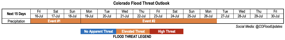
Valid Dates: 7/16-7/30
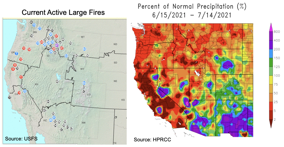
If we rewind back to mid-June, after an intense, record breaking early summer heat wave plagued the state, there was significant concern of another off the charts wildfire season given the dry vegetation. Now just one month later, we are seeing a fortunate reversal of events, at least for Colorado, as above normal monsoon moisture is expected to hang around the state indefinitely. The maps below compare the ongoing “Large Incidents” wildfire activity from the US Forest Service with 30-day precipitation departures (% of normal). A strong correlation is seen across the western US with wildfires occurring where little to no precipitation has fallen since summer started. Some deviation is seen in central Arizona, but this is likely because most of the precipitation has occurred recently so wildfires have not been entirely suppressed yet.
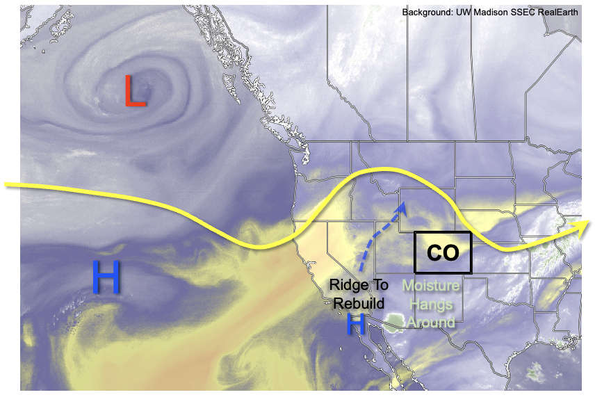
Looking at this morning’s water vapor image, one will notice that we have not zoomed out as much as normal. This is because most of the important atmospheric features for this Outlook will be “circling around” the Four Corners for the next 10-15 days. The key feature to watch will be the placement and intensity of the so-called “Monsoon Ridge”, which is currently in latency over southwest AZ. This feature will quickly intensify and move N/NE to hold a position north of Colorado within 72 hours. Thereafter, this ridge is expected to maintain near-stationarity for the duration of this Outlook. With the position of the ridge to our north, this will allow for the transport of moisture and disturbances from the east, a fairly unusual occurrence for us. And with plenty of moisture available over NM and AZ to transport northward, we expect a rather active pattern for the daily occurrence of scattered heavy rainfall mainly focused over the climatologically favored parts of western and southwestern Colorado.
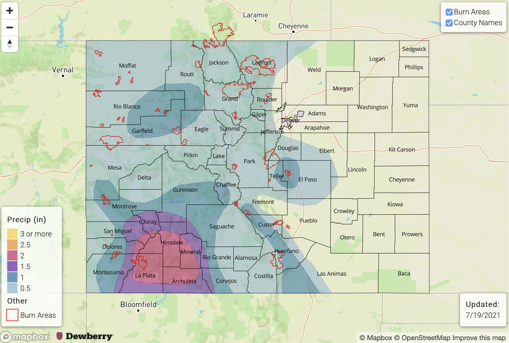
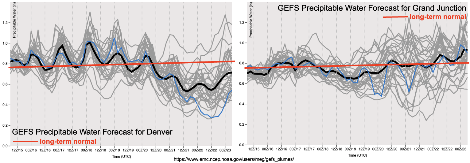
As seen in the forecasted Precipitable Water plumes for Denver and Grand Junction, above normal moisture will hang around most of the state over the next 72 hours. Thereafter, some drying will occur east of the Continental Divide as a cut-off low pressure is forecasted to move into the southern Great Plains. Subsidence and some dry air transport will reduce moisture over northeast Colorado. However, above normal moisture will persist west of the Continental Divide, especially over the southwest parts of the state leading to thunderstorm activity capable of generating heavy rainfall and flooding.
For this Outlook, we have identified two precipitation events, which are described in more detail below.
Event #1: Friday – Sunday (July 16 – July 18)
Low-end Elevated Flood Threat for eastern Plains as well as central and southern high terrain
There is significant uncertainty with this event, especially given the short lead time. However, the passage of a disturbance is expected to yield scattered to possibly numerous shower and thunderstorms activity on Friday. Higher elevations of the Northern, Central and San Juan Mountains are expected to see isolated heavy rainfall up to 1.0 inch per hour. Farther east, there is an increasing likelihood of organized clusters of storms moving off the high terrain and into the lower elevations. Rain rates over the lower elevations are uncertain, but enough moisture is available to sustain 1.5 inches/hour or more, which would support isolated flash flooding. Severe weather, both strong winds and hail, are also possible with the stronger storms towards the NE and KS borders. By Saturday and Sunday, most activity over the Plains is expected to subside, but scattered storms should continue over the central and southern high terrain, capable of producing 1.0 inch per hour of rainfall.
Event #2: Monday – Monday (July 19 – July 26)
Persistent Elevated Flood Threat over southwest Colorado
An increase in monsoon-origin moisture is expected to enter southwest Colorado beginning Monday, leading to an increase in the northward extent of thunderstorm coverage. Unfortunately, it is currently difficult to pinpoint which days will be most threatening, which will be hashed out in daily Flood Threat Bulletins. However, at least scattered storm activity is expected every day over the next week, and it is very likely that several days will likely have particularly high potential to produce heavy rainfall. Maximum 1-hour intensity locally exceeding 1.0 inch looks like a very good bet nearly every day with this event. While over this 8-day period covered by this Event, we foresee up to 2.5 inches of total precipitation over the San Juan Mountains with lower totals in surrounding areas. At this time, there is significant uncertainty as to how much rainfall will occur in the lower elevations east of the Continental Divide, as most indications are for subsidence to dominate through at least the weekend of July 24-25.