Issue Date: Monday, July 12th, 2021
Issue Time: 3PM MDT
Valid Dates: 7/13 – 7/27
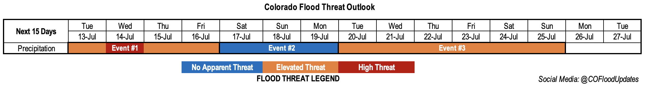
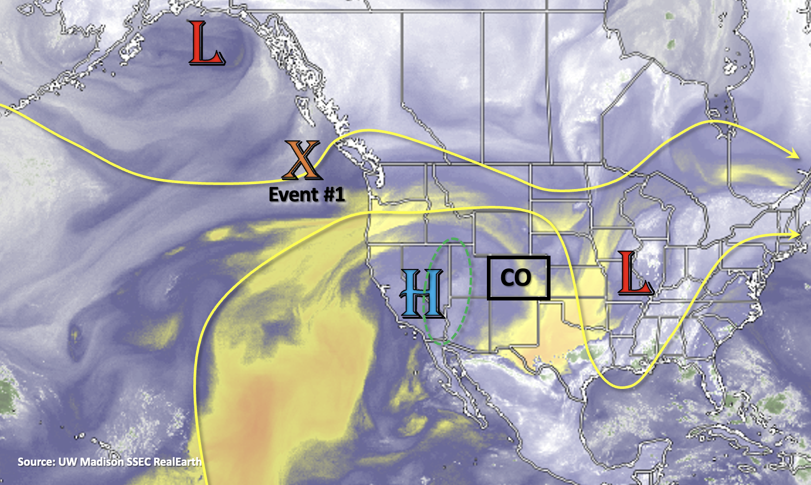
It is a very active FTO outlook, which is not surprising now that Colorado is into its primary heavy rainfall season. With that said, we’ll jump right into it. Event #1 begins tomorrow as an incoming shortwave (orange “X”) displaces the ridge axis slightly east, which will push a moisture plume (green dashed oval below) over western Colorado. Initially, the dry surface layer is expected to hinder efficient rainfall rates (west), but by Wednesday, the plume is expected to moisten the surface layer and generally increase PW values across the state. This will make precipitation both more efficient at reaching the surface and more widespread in coverage, which is one of the reasons why a High/Elevated flood threat is issued for this event. The ridge begins to rebuild on Thursday and Friday, but lingering moisture will keep scattered, mountain storms in the forecast. As the High begins to rebuild over the 4-corners region over the weekend, there should be a downtick in rainfall activity (Event #2). Residual moisture and the diurnal cycle will likely still produce isolated to scattered storms over the mountains each day this weekend, which may spill into the adjacent eastern plains (south). Less measurable rainfall and storm activity is expected on Monday as the strengthening High will likely be in a location that will entrain a dry air mass over the state.
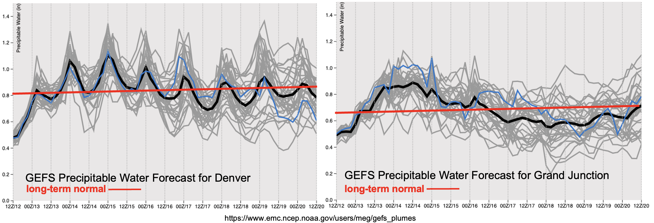
Event #1 is well defined in the PW plumes below, especially west (right plot). The plume begins its arrival over western Colorado tomorrow, and PW remains above normal through Thursday. The GEFS then indicates a drying trend through this weekend over the western portion of the state. Over eastern Colorado, the peak in PW is slightly delayed arriving on Wednesday morning. While there looks to be a slight downtick in PW by Friday over eastern Colorado, there could still be some above average PW values. This is shown by the larger spread within the GEFS over eastern Colorado (gray lines, left plot). If high moisture ends up hanging around, the threat level for Event #2 may be briefly elevated this weekend. For now, there is No Apparent Threat, but be sure to check back into the FTO on Thursday afternoon for the latest.
Looking ahead to next week, both the GEFS and EPS hint at a strong ridge rebuilding over the western US. Not only will this bring the next potential heat wave, but it could be an opportunity for a strong moisture surge depending on where the ridge axis is located. As is typical, the moisture plume would likely first arrive to western Colorado and then eastern Colorado with the passage of a shortwave to our north displacing the ridge axis. Given that the models have been hinting at a long period of elevated PW, indicating multiple days of (potentially) heavy rainfall, the event was worth mentioning in today’s FTO. No map has been drawn below for Event #3 due to low confidence in the rainfall placement.
Keep scrolling below to read more details about Event #1 and Event #2
Event #1: Tuesday – Friday (7/13 – 7/16)
High/Elevated flood threat as the next moisture plume pushes in from the west.
Rainfall chances return to western Colorado by tomorrow. Soundings further to the west, near the moisture plume, show the majority of the moisture at the mid-levels. That indicates that tomorrow, rainfall will produce some stronger outflow winds and virga (north). Mid-level energy moving through the flow will likely help produce more widespread coverage over the next couple of days as well. Heading into Wednesday, rainfall should become more efficient with better saturation at the surface from Tuesday’s storms. This along with the general increase in PW across the state warrants a a one-day High flood threat. The heavy rainfall threat over western Colorado is expected to be more focused over the southern high terrains. Over eastern Colorado, more widespread rainfall is expected on Wednesday. With more northerly steering flow, storms are not expected to spill into the adjacent plains much. The best chance for this occurring will be south over the Raton Ridge. On Wednesday, a couple severe storms may be possible along a cold front that moves through. This scenario is more likely if the front arrives during peak heating. Generally, faster steering flows for this event should keep the flood threat more isolated each day. Be sure to tune into the FTB for the latest.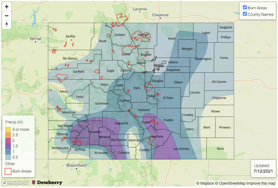
Event #2: Saturday – Monday (7/17 – 7/19)
No Apparent flood threat as a weak ridge rebuilds and daily rounds of mountain storms build with residual moisture.
There should be a break in heavy rainfall chances heading into this weekend. Daily rounds of mountain precipitation are still forecast with the diurnal flow and residual moisture, but storms are expected to be more isolated. If the said higher moisture is able to hang on over eastern Colorado this weekend, the flood threat would be more localized rather than widespread favoring the souther mountains. Monday looks to be less active than this weekend, but some weak storms will still be possible over the mountains (south). At this time, there is No Apparent flood threat issued for this event.