FTO 08-05-2021: Long-Awaited Break From Heavy Rainfall Has Arrived

Issue Date: Thursday, August 5th, 2021
Issue Time: 2:50PM MDT
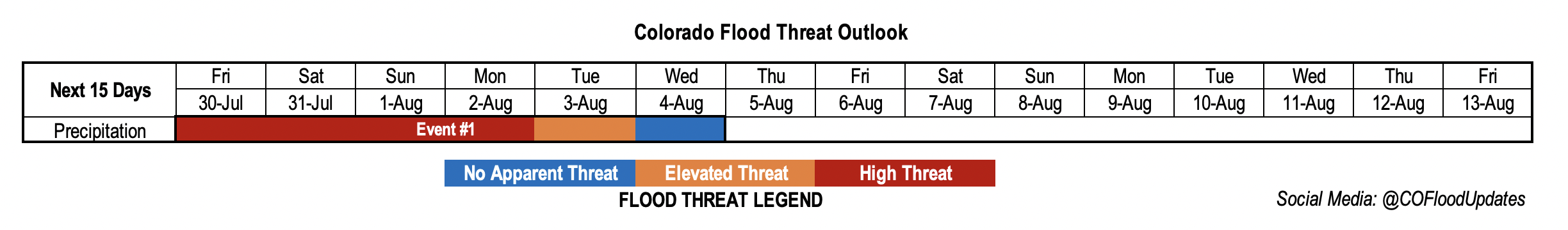
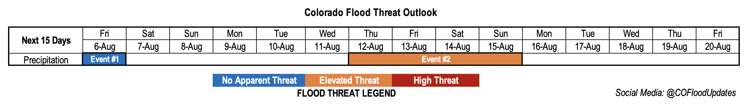
Valid Dates: 8/6 – 8/20

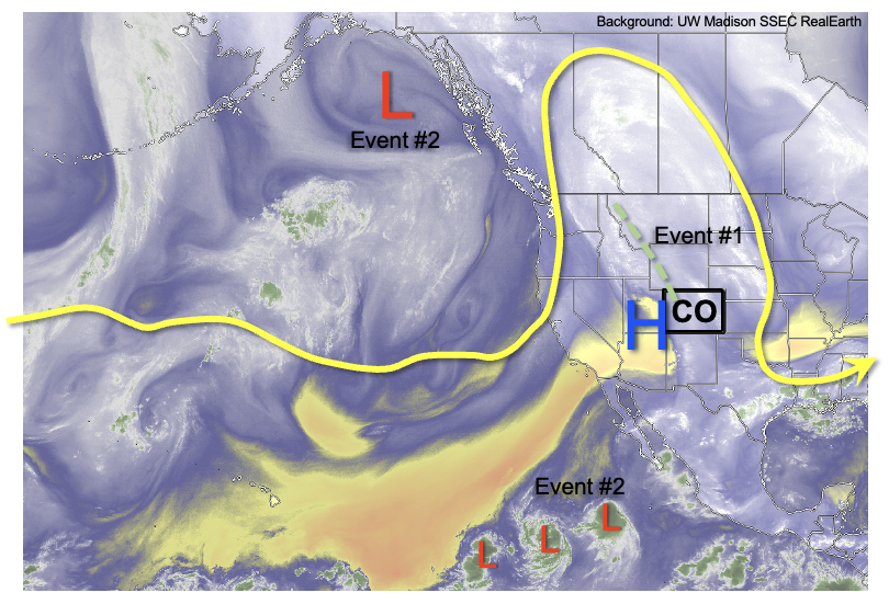
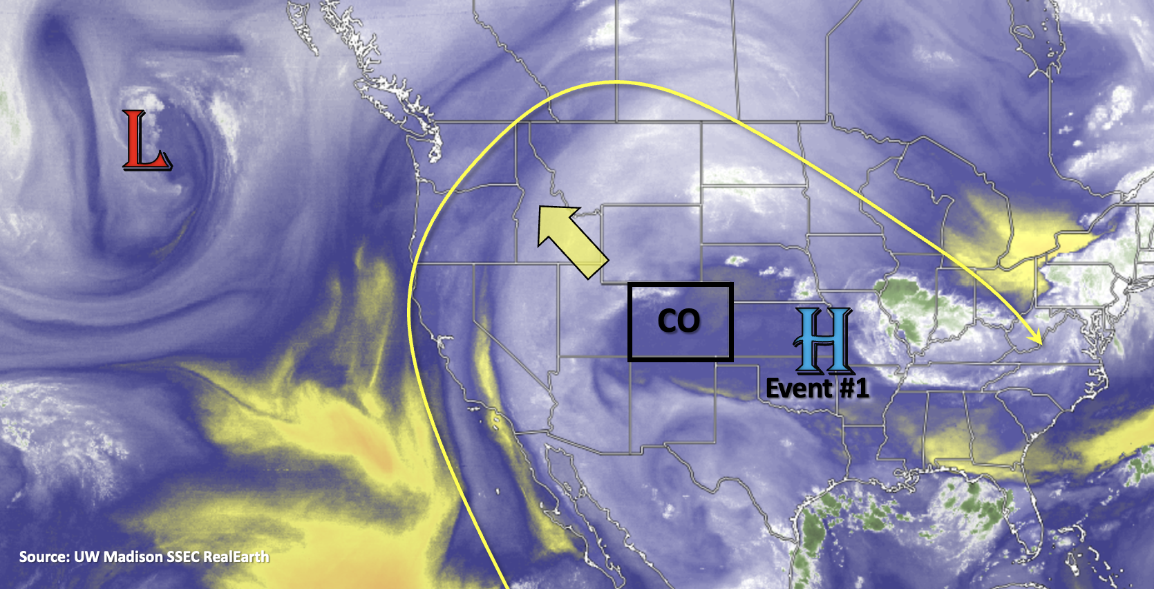
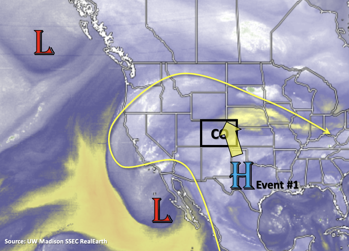
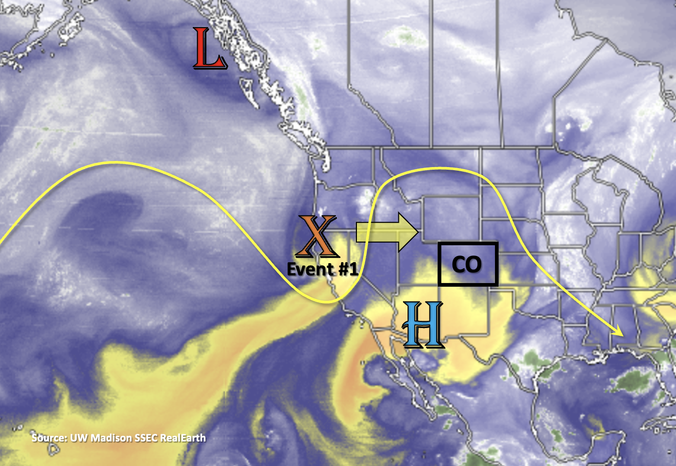
Finally, we’ve reached the long-awaited break in heavy rainfall activity as the axis of the ridge moves into an unfavorable position for a subtropical moisture surge over the state. Tomorrow, a quick-moving shortwave (orange “X”) moves across our northern border. As it passes, it should help spark some scattered storms over the mountains, which will likely spill into the adjacent plains by the afternoon and evening hours. However, with the dry west and northwesterly flow aloft over the state and not much surface moisture associated with the shortwave, the storms are not expected to produce a flood threat but more of a wind threat. The increase afternoon cloud cover and very modest rainfall for limited areas will be a nice break from the heat as high temperatures will run ~5 to 8 degF above average.

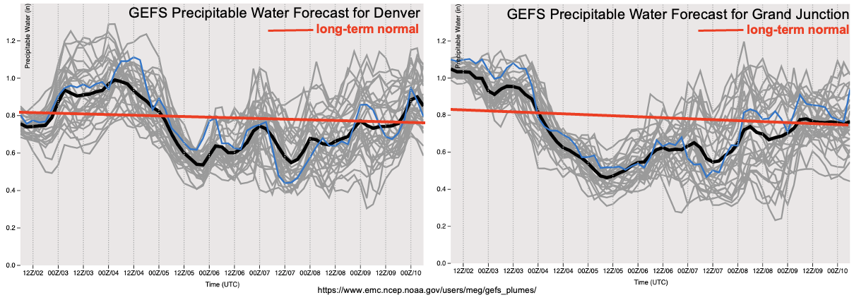
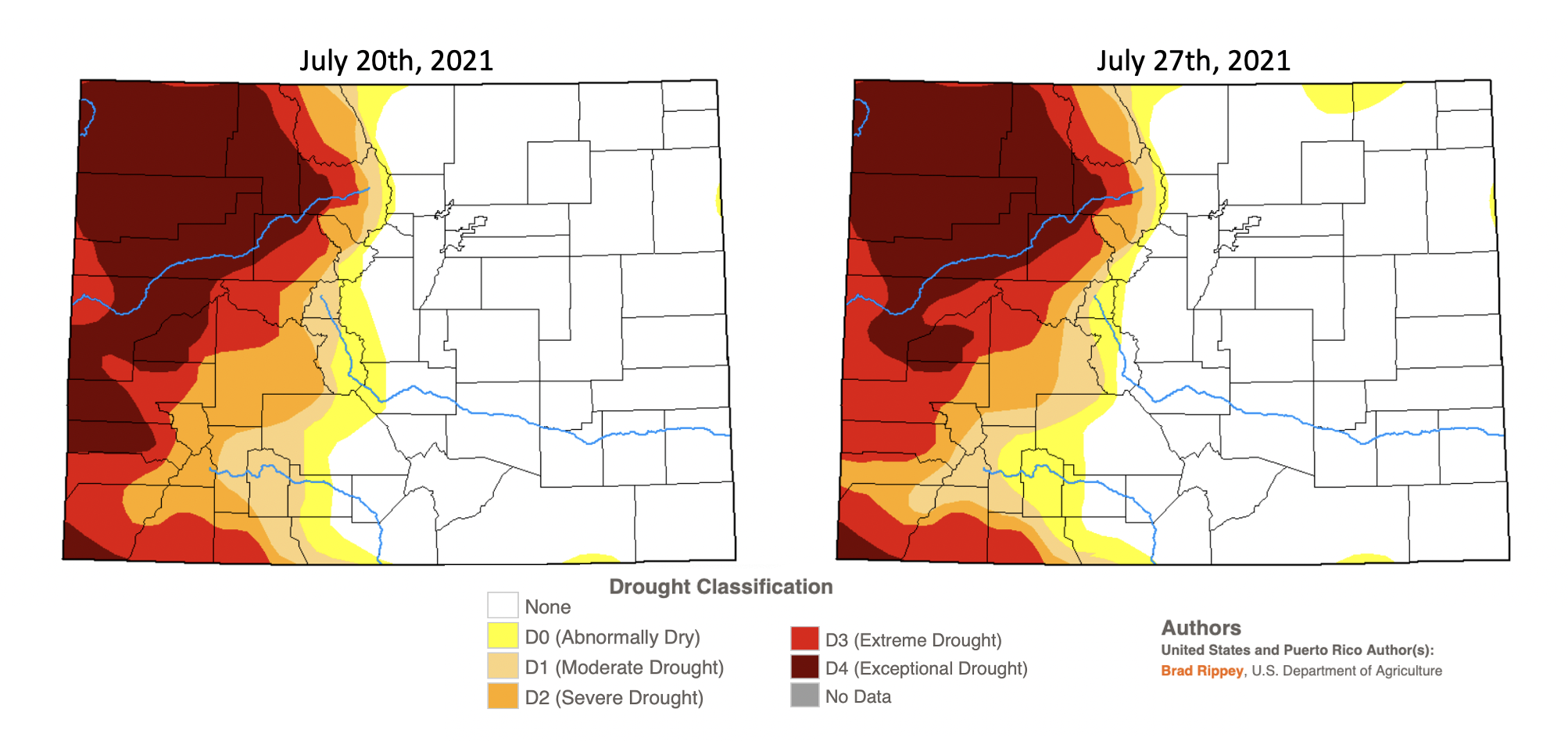
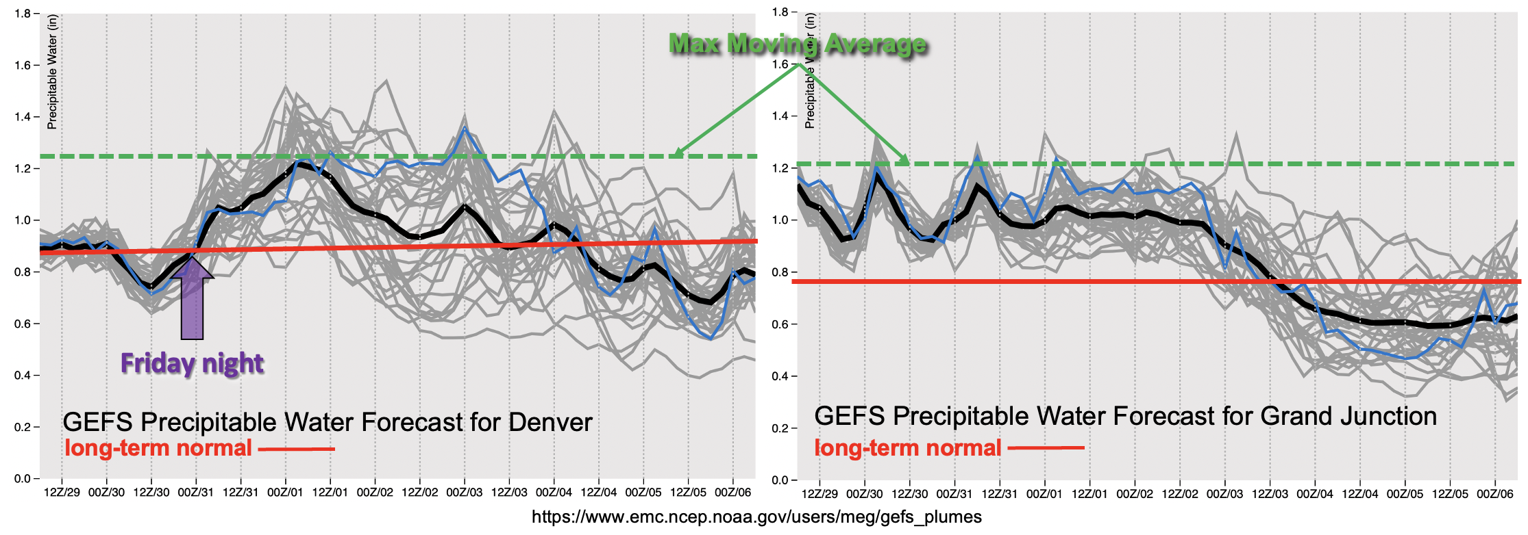
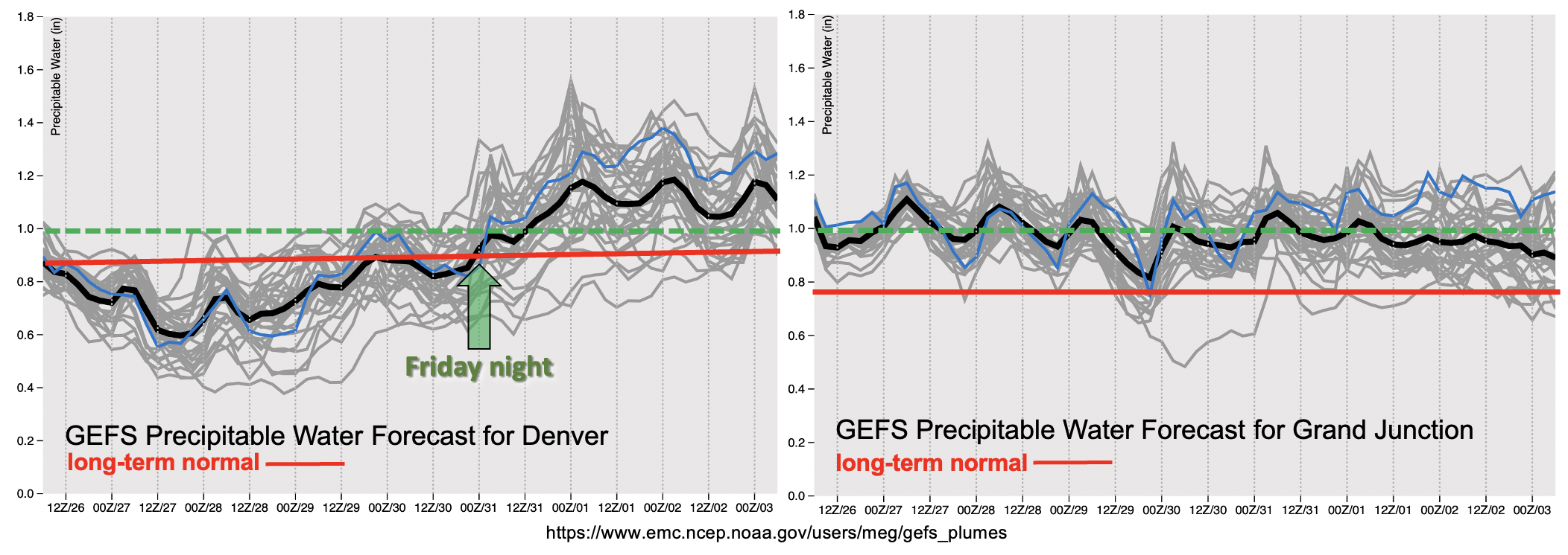
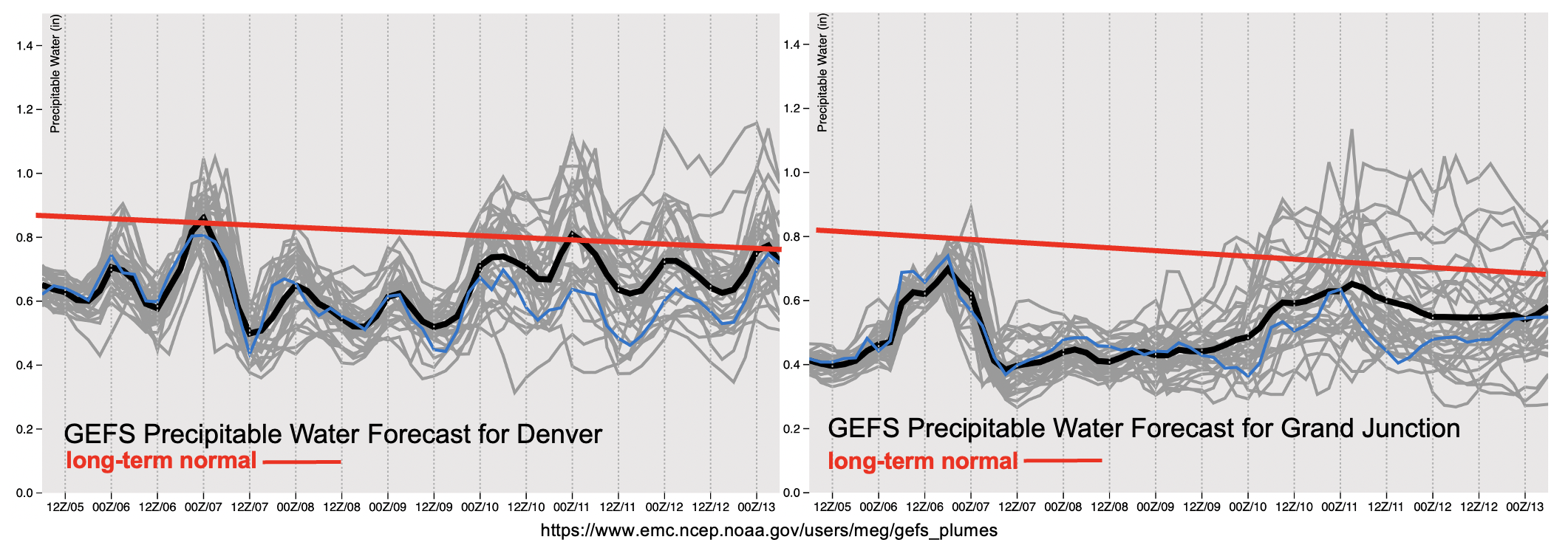
After Event #1, it should be fairly quiet the rest of the week with PW below normal for this time of year. Some showers and weak storms may still be possible over the mountains with the residual moisture, but it’s more likely we’ll only see afternoon, fair weather cumulus clouds and plenty of virga. Taking a look at the red solid lines below, you can see that we’ve started our downward trend in the long-term normal for PW. That doesn’t mean the heavy rainfall threat is over for the season, but climatologically over the next week or so, we typically see our monsoon season begin to wind down. The plumes do hint at a slight rise in PW by the end of end of next week, but the separation in the gray lines still show a lot of uncertainty in this forecast. The upward trend in PW indicates that this will be the next opportunity for a moisture surge not this weekend, but next weekend. An Elevated flood threat has been issued for this event, but it is very likely that the forecast could change given the uncertainty this far out. Be sure to tune into the FTO next week to keep tabs on the changes for Event #2.

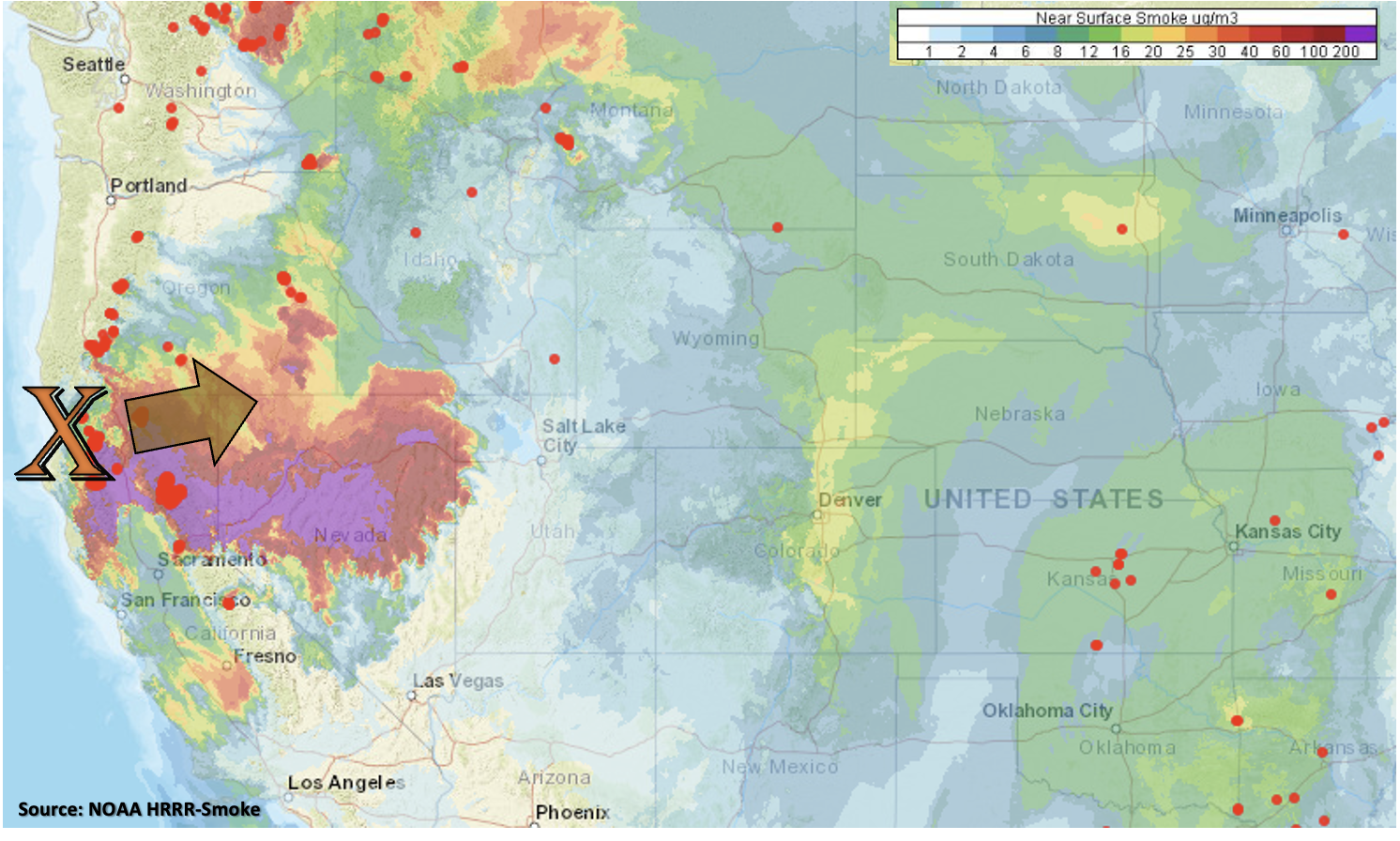
Below is the near surface smoke from the HRRR model with ongoing fires marked by the red dots. There is already some relatively thick near-surface smoke over the I-25 Corridor and eastern foothills with the integrated smoke (full atmospheric column) showing even higher concentrations (not pictured). The advection of smoke with the northwest flow is impacting visibility quite a bit today, and the air quality alert continues. So, the big “weather” feature over the next couple of days will be the wildfire smoke increasing across the state as the flow becomes more zonal with the approaching trough. Expect that big plume of near surface smoke (pink/red shades below) to arrive to western Colorado by tomorrow evening and eastern Colorado by Saturday morning. So although a dry and warm weekend is ahead, anticipate limited visibly.

Keep scrolling below to read a few more details about the events for this FTO.

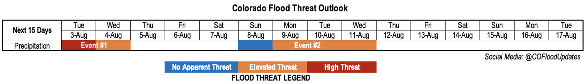
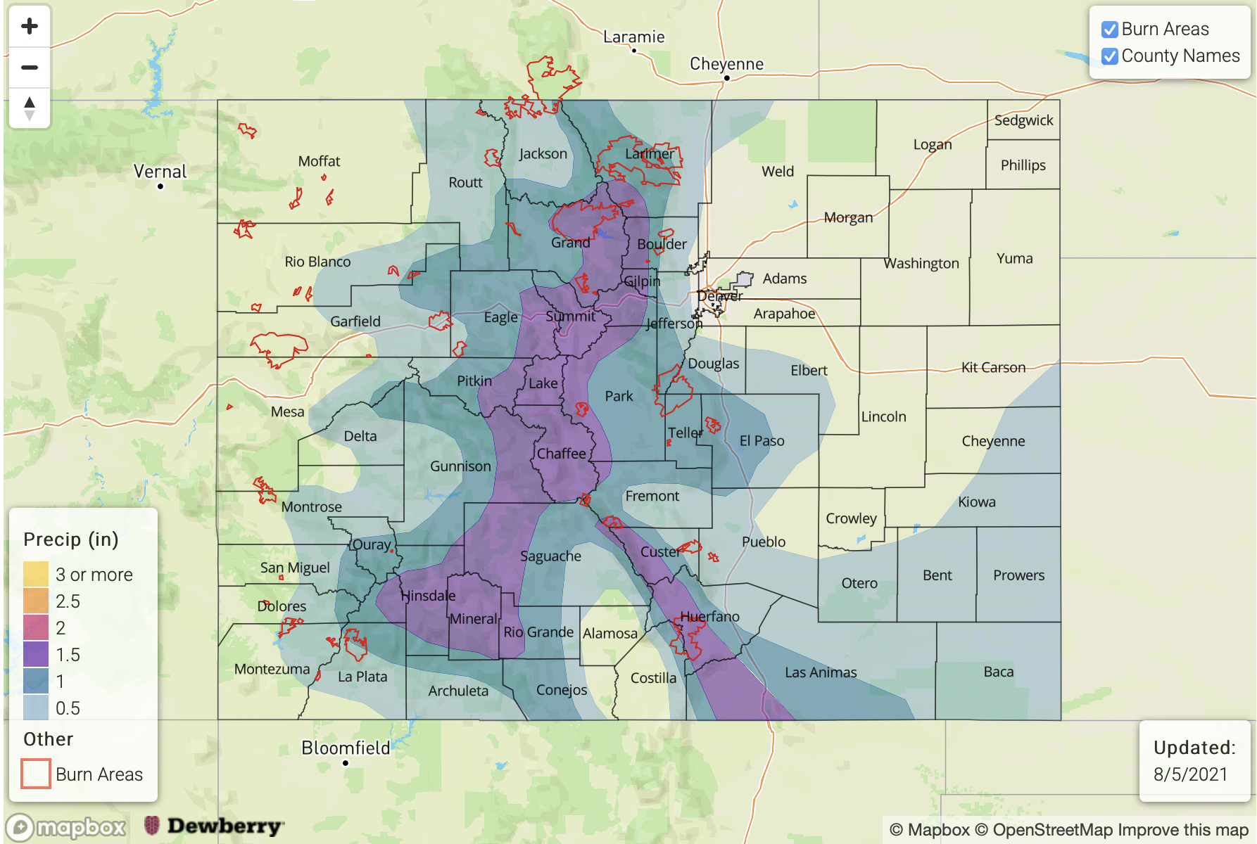
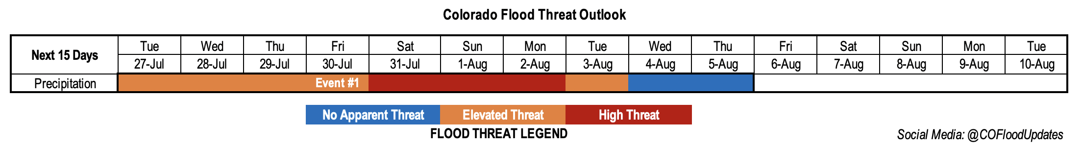
Event #1: Friday (8/5)

No Apparent threat as scattered storms will likely develop over the mountains and produce more of a wind than heavy rainfall threat.

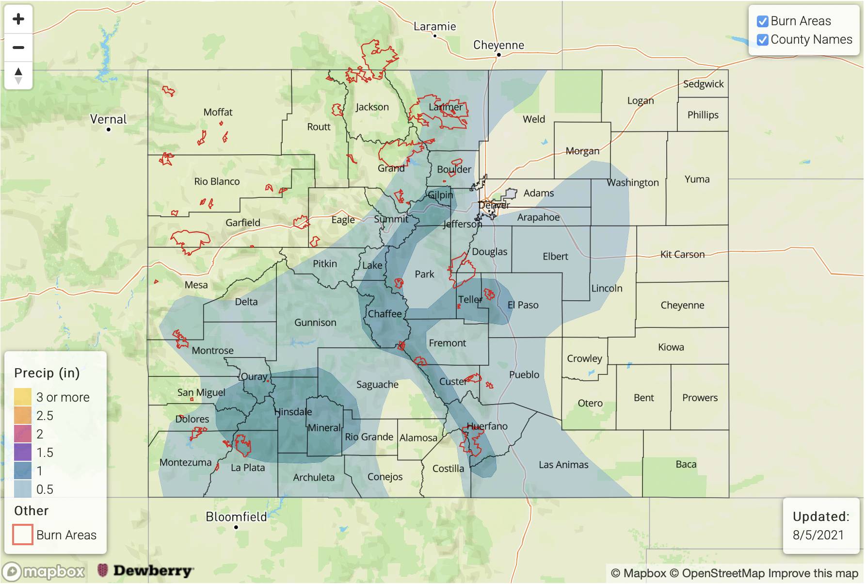
No map has been drawn below to the one-day event likely producing precipitation totals under 0.50 inches. Scattered storms are expected develop by early afternoon over the mountains and spill into the adjacent plains by late afternoon. Due to the drier air, storms will likely dissipate rather quickly and could produce some strong outflow winds. The increased mid-level lift from the vorticity maximum will help support this wind threat over the mountains as well. The tightening surface gradient is also forecast to produce higher surface winds over the Northwest Slope. Paired with low dew points (relative humidity) over the area there is an increase in fire danger over that region. So, a Red Flag Warning has been issued. Flooding is NOT expected with this event.

Event #2: ThursdaySunday (8/128/15)

Next shot at a moderate monsoon moisture surge, so an Elevated flood threat is issued.

Quite a bit of uncertainty in an event this far out, and details will inevitably change. Between the northwesterly flow pushing disturbances through the state and a more active Pacific (hurricane season), there is a chance for an increase in moisture over the area. Extra dynamics could also be at play with mid-level energy likely moving through the flow during this period, so an Elevated flood threat has been issued. Chosen not to draw any maps due to the uncertainty of the forecast, but just wanted to look ahead to the next potential rainfall event.

FTO 08-02-2021: A Busy 48 Hours, Then Significant Drying Before Next Monsoonal Surge

Issue Date: Monday, August 2nd, 2021
Issue Time: 3:05PM MDT
Valid Dates: 8/3-8/17

It is obvious to most folks over the Western Slope that the 2021 monsoon season has been very impressive thus far. Total precipitation over the past month or so has been running up to three times above normal for isolated locations. However, perhaps even more impressive is the persistent nature, and hydrologic response of all the rainfall. As shown below, the Colorado River flow at Cisco, Utah, which is after the confluence of the Dolores River, captures the essence of most of the Western Slope’s monsoonal runoff (though it does miss the San Juan River that flows into NM). Impressively, the flow here has been generally rising for the past 30+ days, which is extremely unusual given the Colorado River’s snowpack-dominated hydrology. In fact, the current flow is actually the highest on the river since June 17th, a time of year that typically sees a median flow of nearly 20,000 cfs versus the ~4,000 cfs in early August. This has only happened once since reliable records began in 1913. Interestingly, that year was 2012, another year with a very low snowpack.

Switching gears to the current Outlook, the visible satellite image below shows that the monsoonal ridge remains over the Four Corners, for now. Although significant changes are in store, the next 48 hours will continue to see heavy rainfall over the high terrain, warranting a High/Elevated threat for Event #1. A plume of very high moisture is in place over Colorado and will continue to produce persistent moderate to heavy rainfall along the Continental Divide higher terrain. Precipitation will have a hard time spilling east of the higher terrain, however, so the eastern plains will unfortunately miss out on this monsoonal moisture surge.

As shown in the forecasted PW plumes, below, a steep drop in moisture is expected as dry air infiltrates from the west. Thereafter, the upper-level ridge moves east while simultaneously elongating westward. This is not a favorable position for precipitation in Colorado, although residual moisture could be underestimated leading to at least isolated showers and storms later this week. By this weekend, however, an incoming trough is expected to interact with sufficient monsoonal moisture, aided by 3 tropical cyclones in the eastern Pacific to produce an increase in shower and storm coverage across Colorado. At this time, this event, Event #2, looks to carry a low-end Elevated threat.

Each of the two identified precipitation events are described below.

Event #1: Tuesday – Wednesday (August 3 – August 4)

High Threat On Tuesday, Then Elevated Threat By Wednesday

Widespread moderate to heavy rainfall is expected over the higher terrain once again on Tuesday, shifting slightly east compared to Monday’s placement. We are expecting widespread amounts over 1 inch above 8,000 feet. Hourly rainfall intensity will not be particularly impressive, perhaps 1.0 inch/hour, but 3-6 hour totals approaching 2 inches warrant a High threat especially due to the existing saturated soils. By Wednesday, the moisture plume shifts southeast and the Southeast Mountains and Raton Ridge will likely see the bullseye of heavy precipitation. Up to 2 inches of rainfall is expected once again, though storm coverage will likely be slightly lower, hence the expected Elevated threat.

Event #2: Sunday – Wednesday (August 8 – August 11)

Low-end Elevated Threat Expected in Climatologically Favored Regions

After a lull of several days, PW is expected to once again exceed 1 inch over southern and central Colorado, leading to an uptick in storm coverage and rainfall intensity by this weekend. Daily rounds of showers and storms are expected in the San Juans, Central Mountains, Southeast Mountains and possibly Front Range. Up to 1.0 inch per hour in rainfall intensity appears possible, which would be enough in sustaining the threat of debris slides and mud flows over the higher terrain. The degree to which storms are able to persist east of the foothills is uncertain, but the best chance for this would be east of the Palmer Ridge, in consistency with climatology.

FTO 07-29-2021: Heavy Rainfall & Possible Riverine Flooding Over The Weekend

Issue Date: Thursday, July 29th, 2021
Issue Time: 2:55PM MDT
Valid Dates: 7/30 – 8/13

It has been a significant 2021 monsoon season so far, and there has been lots of rainfall over the last couple of weeks. This is especially true across the southern mountains and portions of the Southwest Slope. A new drought map was release today, which is valid through Tuesday, July 27th, so precipitation from yesterday is not included. I am happy to report that the Exceptional Drought conditions over the western portions of Mesa, Montrose and San Miguel have been reduced to the D3 category. And for the most part, all the locations over the San Juan Mountains have been reduced a drought classification level. While this is great news, about 33% of Colorado is still under a Severe (D3) to Exceptional Drought (D4). This next FTO event is expected to drop some significant rainfall over the southern Northwest Slope, Central Mountains and San Juan Mountains again, so hopefully drought conditions will continue to improve. It looks like there might be one, and if we’re lucky two, more taps into the monsoon moisture after Event #1 before the North American Monsoon wraps up across western CO.

Not much change in the overall pattern as the ridge begins to build in strength through the weekend. That means that the hot temperatures will continue across the state minus a noticeable cool down over eastern CO and the mountains Saturday and Sunday (especially the mountains). With the ridge axis building back over the Great Basin, the elongated shape will help to keep high moisture across the state for plentiful rainfall during Event #1. Shortwaves moving around the flow and from the Low over the Pacific should chip away at this dominating ridge pattern beginning next week. This will likely suppress the High south and west, which will reduce the PW surge over the state and finally give us a break from all the heavy rainfall. But before the break in heavy rainfall, there is the possibly for a SIGNIFICANT flooding event over this weekend (Event #1).

Below are the GEFS Precipitable Water plumes over Denver (left) and Grand Junction (right) through Wednesday, August 5th. As shown in Monday’s FTO, there is an aggressive upward surge in PW over Denver Friday morning into Saturday morning (purple arrow) associated with the passage of a cold front. The long-term average PW (red line) is sort of irrelevant since PW both east and west is well-above it. So, added to the graphic below are the maximum moving averages for PW at each location (green dashed). Gray lines above the dashed green line indicate that PW will approach this maximum moving average and may even surpass it this weekend. What this translates to is the possibility for extremely high rainfall rates and widespread, heavy rainfall. Event #1 may be capable of producing riverine flooding on top of the increased threat for mud flows and debris slides due to the widespread nature and possibility for longer periods of rainfall over the eastern mountains this weekend. This message is especially relevant near recent burn areas where excessive runoff is already likely due to hydrophobic soils and lack of vegetation. If you are camping or hiking in the mountains this weekend, please have a way to stay tuned into your local NWS office for Flash Flood Warnings. Also, avoid setting up your tents in low-lying areas or near waterways.

A HIGH FLOOD THREAT HAS BEEN ISSUED FOR EVENT #1. Be sure to tune into the daily FTB for better details about the potential rainfall threat each day, and NWS for real-time warnings. Keep scrolling below to read more details about Event #1.

Event #1: FridayWednesday (7/30 – 8/4)

Widespread, heavy rainfall is likely over the weekend with the possibility for riverine flooding over the eastern mountains, so a HIGH flood threat has been issued.

The long-lasting monsoon moisture surge continues with an uptick in heavy rainfall chances over the weekend into next week. Slower steering flows and well-above average moisture are expected to combine to produce VERY high rainfall rates. Max 1- to-2 hour rainfall rates up to 3 inches are not out of the question, which if those occur, could cause a lot of flooding issues. The widespread and heavy rainfall over the eastern mountains Friday/Saturday (north) into Sunday (south) will also increase the riverine flood threat with totals local totals just over 4 inches possible. The heavy rainfall producing storms will be especially problematic for flooding issues if they track over recent burn areas. Please have a way to stay tuned into your local NWS office, and check back to the daily FTB for details about the potential flooding threats each day.

FTO 07-26-2021: The Lively Monsoon Season Continues For At Least Another Week

Issue Date: Monday, July 26th, 2021
Issue Time: 2:55PM MDT
Valid Dates: 7/27 – 8/10

The monsoon season is still roaring with an Elevated to High flood threat issued over the next week. What a rainfall season it has been so far! Thankfully, monsoon season arrived a little early across western Colorado, which is dealing with the ongoing drought (rainfall climatology peaks in August). However, there are still some areas of the Northwest Slope, Northern Mountains and western valleys that are 0.75 to 1.50 inches below normal in terms of July precipitation. The Northeast Plains are also quite dry for July, and rainfall is 1.50 to 3 inches below average over the northeast corner of the state. The Southeast Plains are likely closer to climatology after the widespread downpour they had yesterday.

As far as the overall pattern this week, the ridge will begin to build northward for Event #1. This will push the Low, that influenced our weather a couple days back (Baja of CA), further west and then around the top of the anomalous strong ridge. As the dominate ridge builds northward, hot temperatures are forecast through this week with a peak in afternoon highs on Wednesday. Daily records have a chance to be broken along the northern Urban Corridor with highs reaching into the upper 90Fs. A cold front will likely slip across the eastern plains on Saturday, which will help to increase the flood threat statewide, and it could help to produce some severe weather/heavy rainfall over the plains this weekend. However, it should provide a nice cool down for those located in northeast Colorado on Sunday.

One of the reasons for the ongoing, elevated flood threat is that high moisture remains intact over western Colorado through at least the end of this week (right image, below). The green dashed line below is the 1-inch PW marker, so this consistent, monsoon surge is at the higher end of climatology. While heavy precipitation may not be as widespread, cells that do develop will have the potential to produce rain rates known to cause flooding issues over the steeper terrains, especially with slower steering flows under the ridge. Over eastern CO (left), there is a slight downtick in moisture as the ridge builds back over the Great Basin for the work week. However, after Friday night, the moisture returns with vigor over the area. The combination of cold fronts, an anomalously strong ridge pulling monsoon moisture north and lee troughs will help to keep moisture elevated statewide through Monday. Thus, a HIGH flood threat is issued for the weekend.

Be sure to tune back into the FTO on Thursday for changes in the details of this event, especially if you plan on hiking or camping this weekend. Keep scrolling below to read more details about this next, long-lasting monsoon surge.

Event #1: Tuesday – Thursday (7/278/5)

Well-above average moisture moves northward over western CO, then east, and it keeps an Elevated/High flood threat in the forecast for the next week.

No real need to separate this event since the moisture surge from the west eventually expands eastward by this weekend. The building High will pull a lot of moisture northward with it, which will sit mostly over western Colorado through the end of the work week. Although the heavy rainfall threat should be more localized when compared to the last few days, the past week of widespread rainfall means that soils are likely saturated. So, where the stronger storms develop will have an increased risk for excessive runoff and mud flows/debris slides. This includes the recent western burn areas. Tomorrow, the higher risk for flooding will be over the San Juan Mountains and elevated plateaus of the Grand Valley and Southwest Slope. By Wednesday, the threat will likely expand northward with the plume of moisture into the Flat Top region. Thursday and Friday, storms are expected to more widespread in coverage over the western high terrains. It is likely that storm cores will produce around an inch of rainfall during this period.

By Saturday, the flood threat expands statewide with heavy rainfall likely returning to the eastern mountains and adjacent plains. Saturday and Sunday have the best potential for heavy rainfall over the plains and some low-end severe weather might also be possible along the front. At this time, it looks like there is a downtick in heavy rainfall chances from Tuesday through Thursday next week, so No Apparent Threat has been issued for the tail-end of this event.

Another factor that influences the daily, heavy rainfall potential are small disturbances embedded in the flow. These subtle features are better tracked on the 12 to 24-hour scale, so be sure to stay tuned to the FTB for the latest.