Issue Date: Monday, July 26th, 2021
Issue Time: 2:55PM MDT
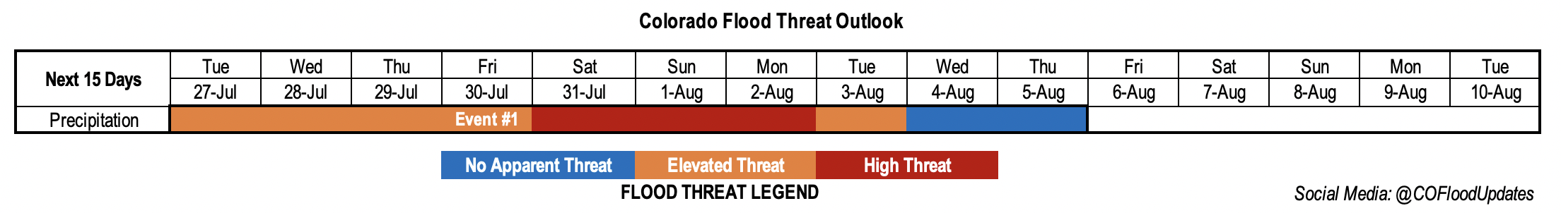
Valid Dates: 7/27 – 8/10
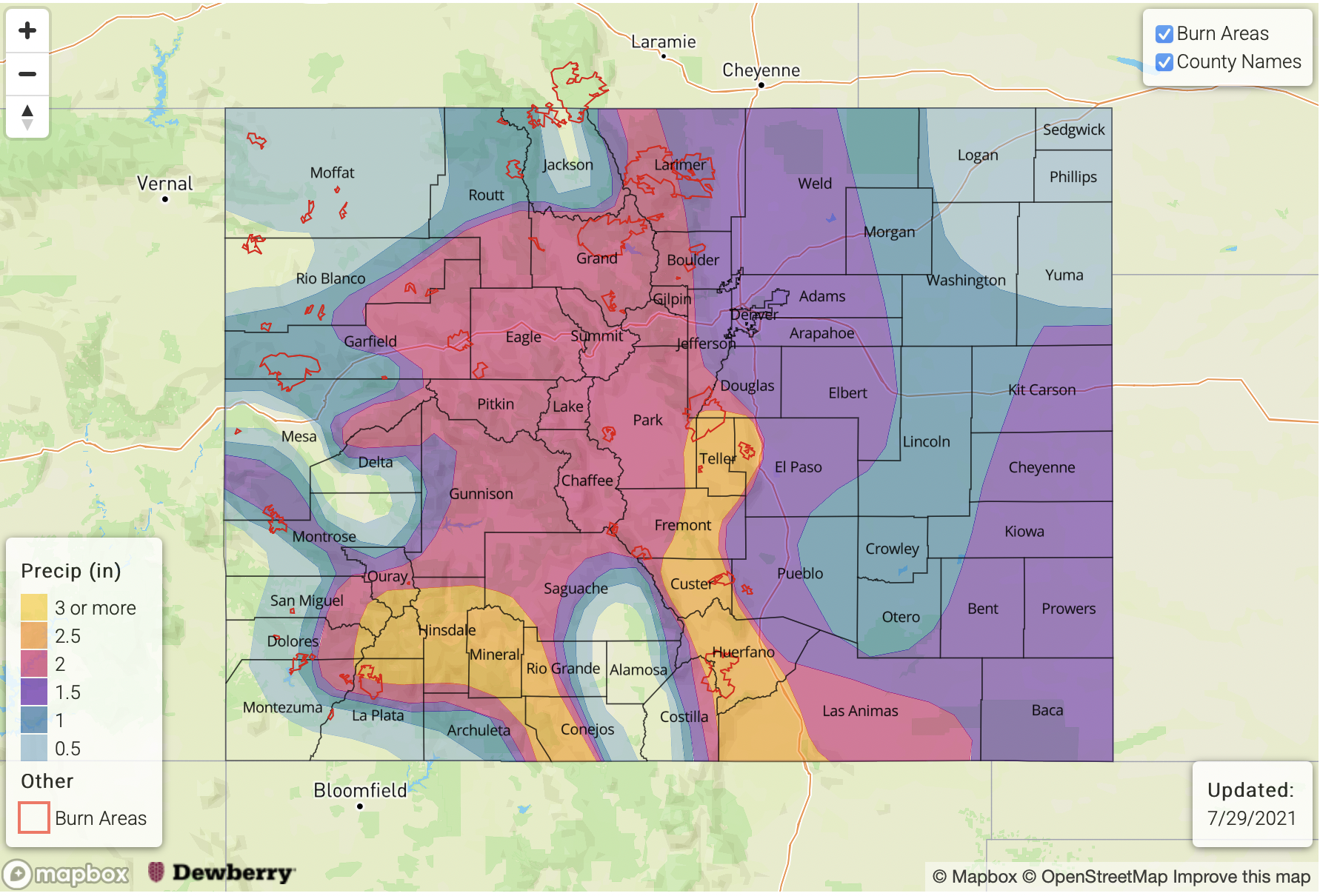
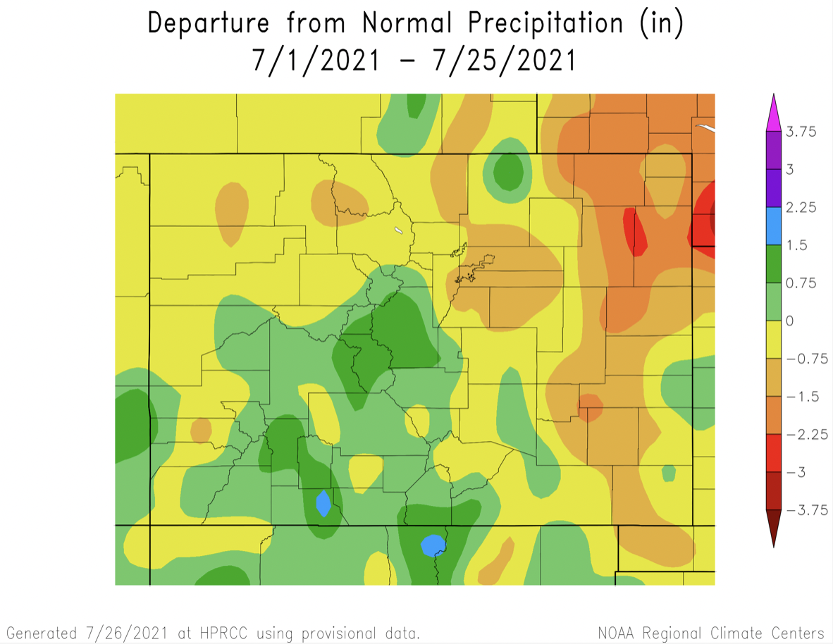
The monsoon season is still roaring with an Elevated to High flood threat issued over the next week. What a rainfall season it has been so far! Thankfully, monsoon season arrived a little early across western Colorado, which is dealing with the ongoing drought (rainfall climatology peaks in August). However, there are still some areas of the Northwest Slope, Northern Mountains and western valleys that are 0.75 to 1.50 inches below normal in terms of July precipitation. The Northeast Plains are also quite dry for July, and rainfall is 1.50 to 3 inches below average over the northeast corner of the state. The Southeast Plains are likely closer to climatology after the widespread downpour they had yesterday.
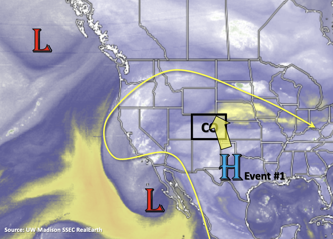
As far as the overall pattern this week, the ridge will begin to build northward for Event #1. This will push the Low, that influenced our weather a couple days back (Baja of CA), further west and then around the top of the anomalous strong ridge. As the dominate ridge builds northward, hot temperatures are forecast through this week with a peak in afternoon highs on Wednesday. Daily records have a chance to be broken along the northern Urban Corridor with highs reaching into the upper 90Fs. A cold front will likely slip across the eastern plains on Saturday, which will help to increase the flood threat statewide, and it could help to produce some severe weather/heavy rainfall over the plains this weekend. However, it should provide a nice cool down for those located in northeast Colorado on Sunday.
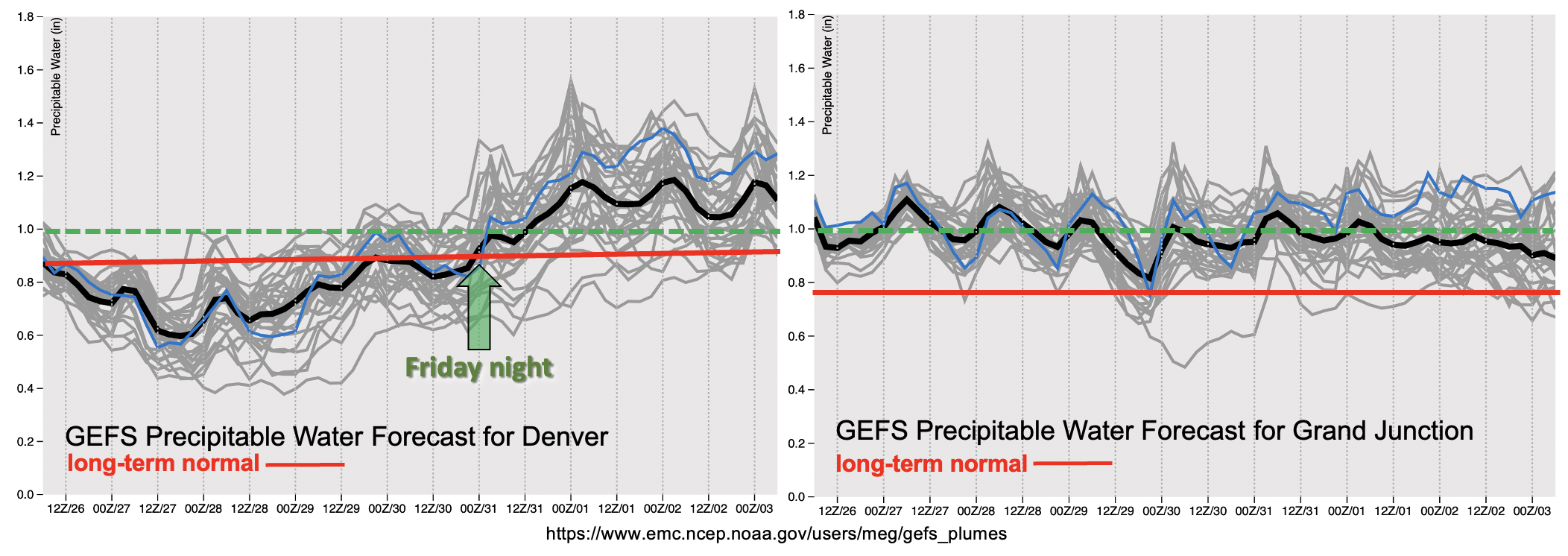
One of the reasons for the ongoing, elevated flood threat is that high moisture remains intact over western Colorado through at least the end of this week (right image, below). The green dashed line below is the 1-inch PW marker, so this consistent, monsoon surge is at the higher end of climatology. While heavy precipitation may not be as widespread, cells that do develop will have the potential to produce rain rates known to cause flooding issues over the steeper terrains, especially with slower steering flows under the ridge. Over eastern CO (left), there is a slight downtick in moisture as the ridge builds back over the Great Basin for the work week. However, after Friday night, the moisture returns with vigor over the area. The combination of cold fronts, an anomalously strong ridge pulling monsoon moisture north and lee troughs will help to keep moisture elevated statewide through Monday. Thus, a HIGH flood threat is issued for the weekend.
Be sure to tune back into the FTO on Thursday for changes in the details of this event, especially if you plan on hiking or camping this weekend. Keep scrolling below to read more details about this next, long-lasting monsoon surge.
Event #1: Tuesday – Thursday (7/27 – 8/5)
Well-above average moisture moves northward over western CO, then east, and it keeps an Elevated/High flood threat in the forecast for the next week.
No real need to separate this event since the moisture surge from the west eventually expands eastward by this weekend. The building High will pull a lot of moisture northward with it, which will sit mostly over western Colorado through the end of the work week. Although the heavy rainfall threat should be more localized when compared to the last few days, the past week of widespread rainfall means that soils are likely saturated. So, where the stronger storms develop will have an increased risk for excessive runoff and mud flows/debris slides. This includes the recent western burn areas. Tomorrow, the higher risk for flooding will be over the San Juan Mountains and elevated plateaus of the Grand Valley and Southwest Slope. By Wednesday, the threat will likely expand northward with the plume of moisture into the Flat Top region. Thursday and Friday, storms are expected to more widespread in coverage over the western high terrains. It is likely that storm cores will produce around an inch of rainfall during this period.
By Saturday, the flood threat expands statewide with heavy rainfall likely returning to the eastern mountains and adjacent plains. Saturday and Sunday have the best potential for heavy rainfall over the plains and some low-end severe weather might also be possible along the front. At this time, it looks like there is a downtick in heavy rainfall chances from Tuesday through Thursday next week, so No Apparent Threat has been issued for the tail-end of this event.
Another factor that influences the daily, heavy rainfall potential are small disturbances embedded in the flow. These subtle features are better tracked on the 12 to 24-hour scale, so be sure to stay tuned to the FTB for the latest.