Issue Date: Thursday, July 29th, 2021
Issue Time: 2:55PM MDT
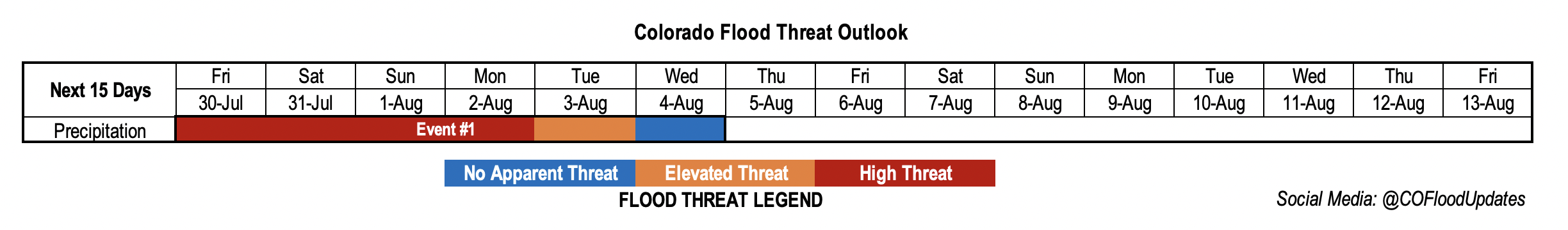
Valid Dates: 7/30 – 8/13
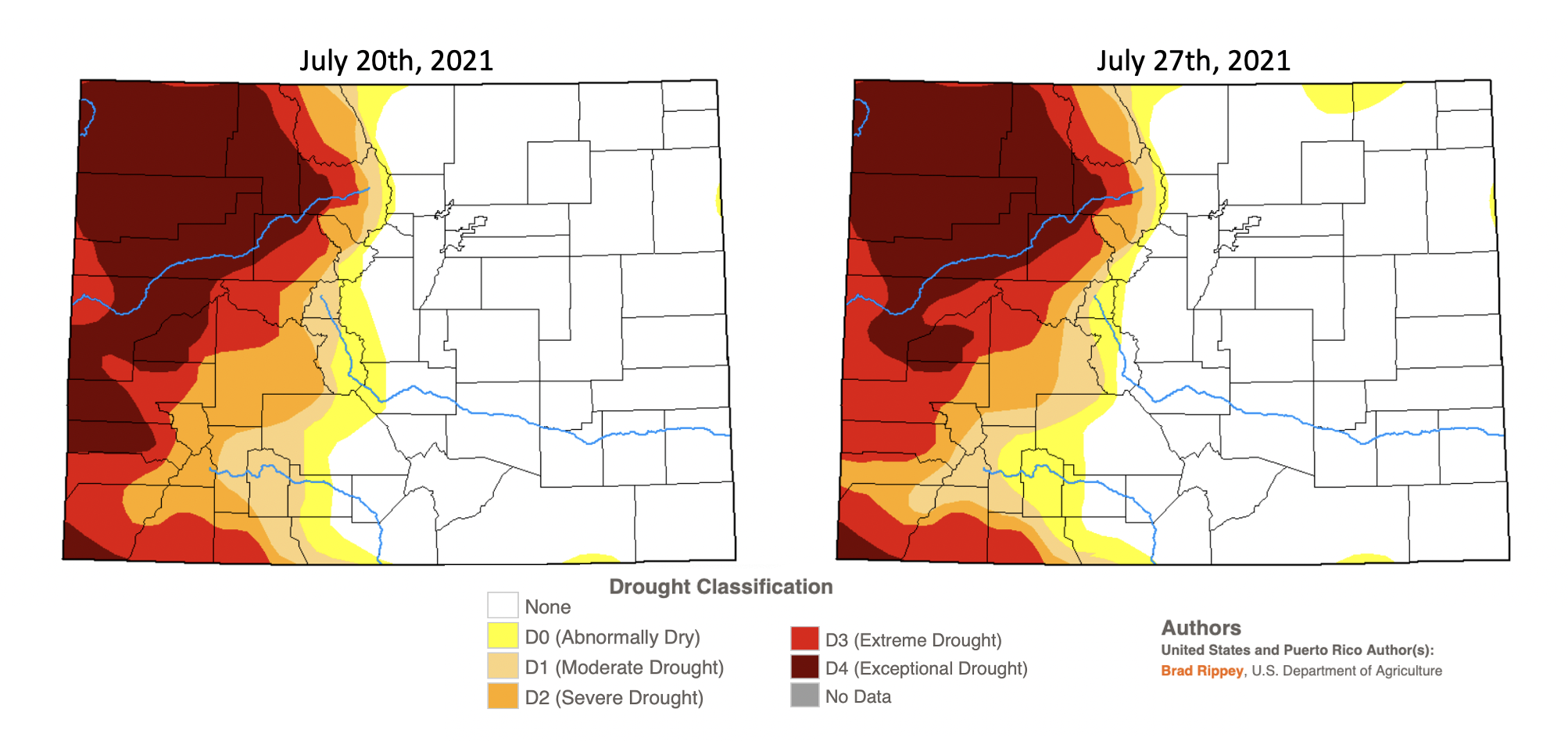
It has been a significant 2021 monsoon season so far, and there has been lots of rainfall over the last couple of weeks. This is especially true across the southern mountains and portions of the Southwest Slope. A new drought map was release today, which is valid through Tuesday, July 27th, so precipitation from yesterday is not included. I am happy to report that the Exceptional Drought conditions over the western portions of Mesa, Montrose and San Miguel have been reduced to the D3 category. And for the most part, all the locations over the San Juan Mountains have been reduced a drought classification level. While this is great news, about 33% of Colorado is still under a Severe (D3) to Exceptional Drought (D4). This next FTO event is expected to drop some significant rainfall over the southern Northwest Slope, Central Mountains and San Juan Mountains again, so hopefully drought conditions will continue to improve. It looks like there might be one, and if we’re lucky two, more taps into the monsoon moisture after Event #1 before the North American Monsoon wraps up across western CO.
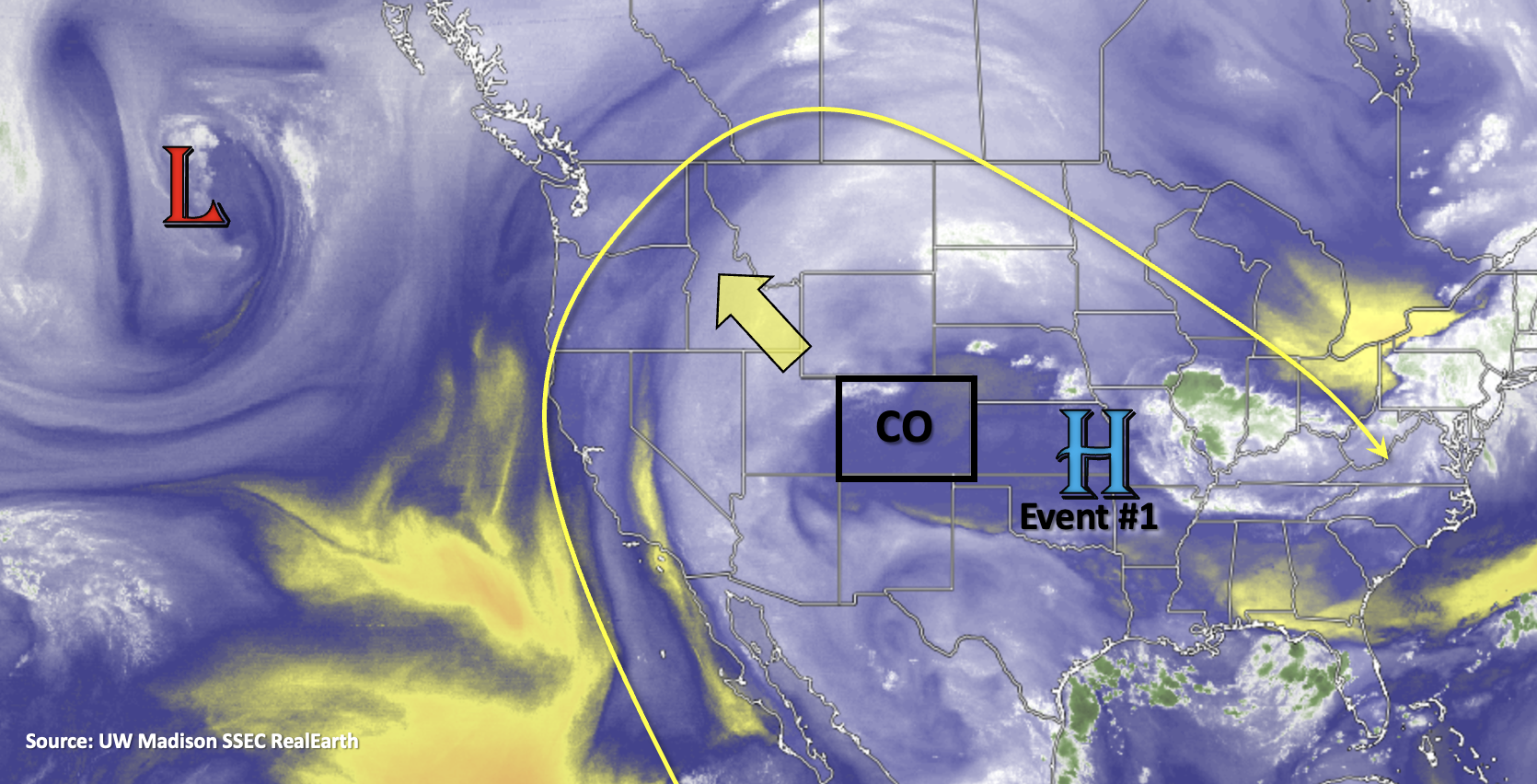
Not much change in the overall pattern as the ridge begins to build in strength through the weekend. That means that the hot temperatures will continue across the state minus a noticeable cool down over eastern CO and the mountains Saturday and Sunday (especially the mountains). With the ridge axis building back over the Great Basin, the elongated shape will help to keep high moisture across the state for plentiful rainfall during Event #1. Shortwaves moving around the flow and from the Low over the Pacific should chip away at this dominating ridge pattern beginning next week. This will likely suppress the High south and west, which will reduce the PW surge over the state and finally give us a break from all the heavy rainfall. But before the break in heavy rainfall, there is the possibly for a SIGNIFICANT flooding event over this weekend (Event #1).
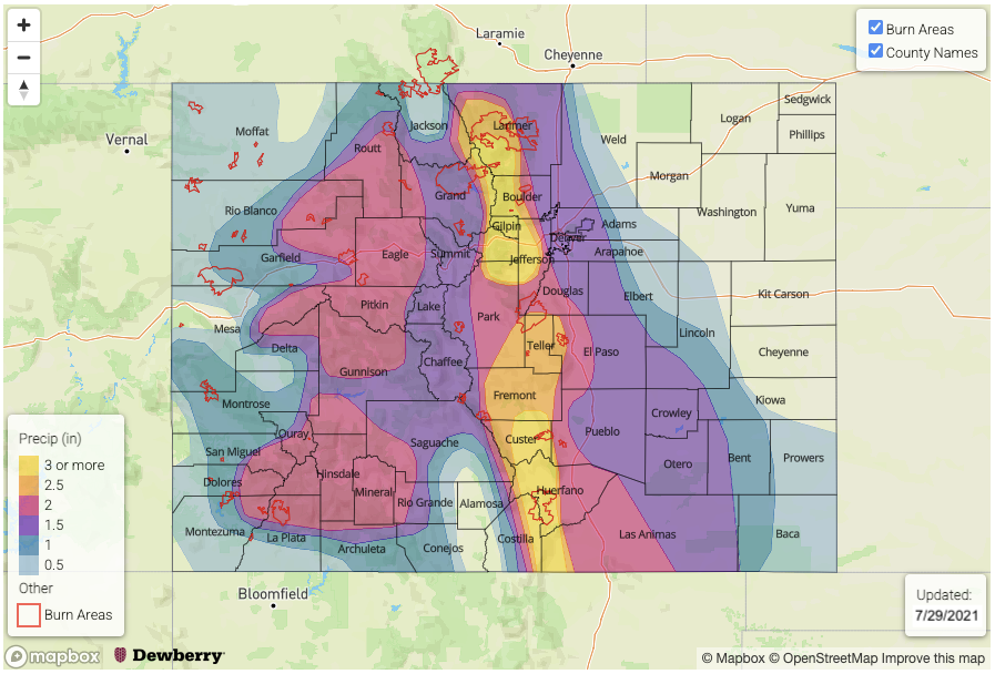
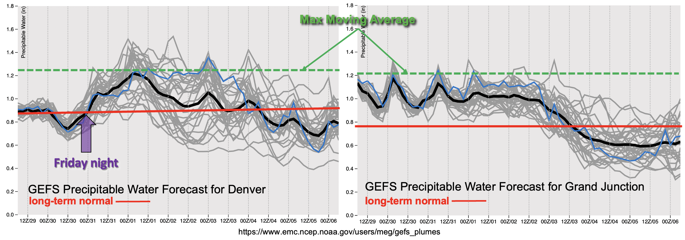
Below are the GEFS Precipitable Water plumes over Denver (left) and Grand Junction (right) through Wednesday, August 5th. As shown in Monday’s FTO, there is an aggressive upward surge in PW over Denver Friday morning into Saturday morning (purple arrow) associated with the passage of a cold front. The long-term average PW (red line) is sort of irrelevant since PW both east and west is well-above it. So, added to the graphic below are the maximum moving averages for PW at each location (green dashed). Gray lines above the dashed green line indicate that PW will approach this maximum moving average and may even surpass it this weekend. What this translates to is the possibility for extremely high rainfall rates and widespread, heavy rainfall. Event #1 may be capable of producing riverine flooding on top of the increased threat for mud flows and debris slides due to the widespread nature and possibility for longer periods of rainfall over the eastern mountains this weekend. This message is especially relevant near recent burn areas where excessive runoff is already likely due to hydrophobic soils and lack of vegetation. If you are camping or hiking in the mountains this weekend, please have a way to stay tuned into your local NWS office for Flash Flood Warnings. Also, avoid setting up your tents in low-lying areas or near waterways.
A HIGH FLOOD THREAT HAS BEEN ISSUED FOR EVENT #1. Be sure to tune into the daily FTB for better details about the potential rainfall threat each day, and NWS for real-time warnings. Keep scrolling below to read more details about Event #1.
Event #1: Friday – Wednesday (7/30 – 8/4)
Widespread, heavy rainfall is likely over the weekend with the possibility for riverine flooding over the eastern mountains, so a HIGH flood threat has been issued.
The long-lasting monsoon moisture surge continues with an uptick in heavy rainfall chances over the weekend into next week. Slower steering flows and well-above average moisture are expected to combine to produce VERY high rainfall rates. Max 1- to-2 hour rainfall rates up to 3 inches are not out of the question, which if those occur, could cause a lot of flooding issues. The widespread and heavy rainfall over the eastern mountains Friday/Saturday (north) into Sunday (south) will also increase the riverine flood threat with totals local totals just over 4 inches possible. The heavy rainfall producing storms will be especially problematic for flooding issues if they track over recent burn areas. Please have a way to stay tuned into your local NWS office, and check back to the daily FTB for details about the potential flooding threats each day.