Issue Date: Monday, August 2nd, 2021
Issue Time: 3:05PM MDT
Valid Dates: 8/3-8/17
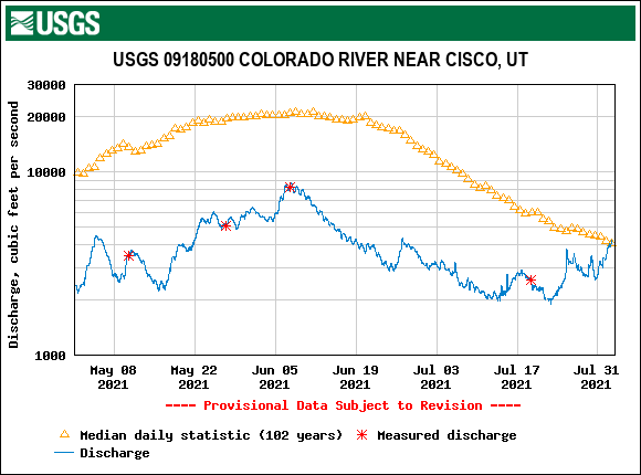
It is obvious to most folks over the Western Slope that the 2021 monsoon season has been very impressive thus far. Total precipitation over the past month or so has been running up to three times above normal for isolated locations. However, perhaps even more impressive is the persistent nature, and hydrologic response of all the rainfall. As shown below, the Colorado River flow at Cisco, Utah, which is after the confluence of the Dolores River, captures the essence of most of the Western Slope’s monsoonal runoff (though it does miss the San Juan River that flows into NM). Impressively, the flow here has been generally rising for the past 30+ days, which is extremely unusual given the Colorado River’s snowpack-dominated hydrology. In fact, the current flow is actually the highest on the river since June 17th, a time of year that typically sees a median flow of nearly 20,000 cfs versus the ~4,000 cfs in early August. This has only happened once since reliable records began in 1913. Interestingly, that year was 2012, another year with a very low snowpack.
Switching gears to the current Outlook, the visible satellite image below shows that the monsoonal ridge remains over the Four Corners, for now. Although significant changes are in store, the next 48 hours will continue to see heavy rainfall over the high terrain, warranting a High/Elevated threat for Event #1. A plume of very high moisture is in place over Colorado and will continue to produce persistent moderate to heavy rainfall along the Continental Divide higher terrain. Precipitation will have a hard time spilling east of the higher terrain, however, so the eastern plains will unfortunately miss out on this monsoonal moisture surge.
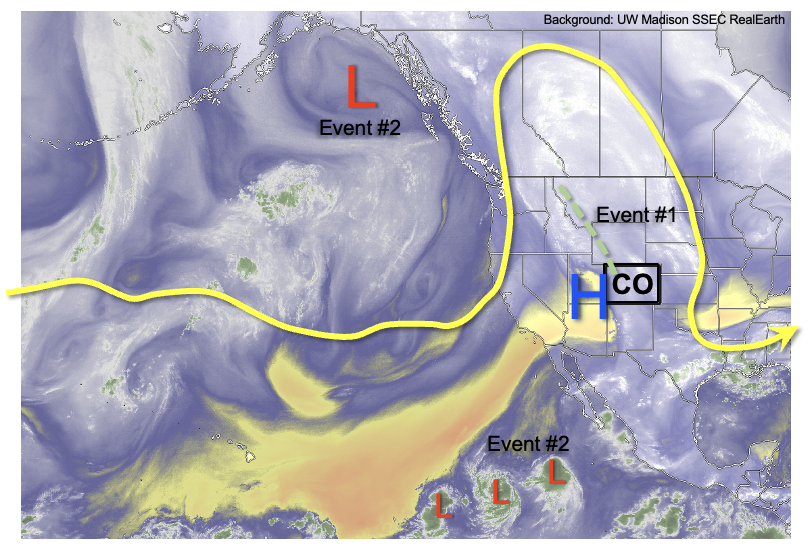
As shown in the forecasted PW plumes, below, a steep drop in moisture is expected as dry air infiltrates from the west. Thereafter, the upper-level ridge moves east while simultaneously elongating westward. This is not a favorable position for precipitation in Colorado, although residual moisture could be underestimated leading to at least isolated showers and storms later this week. By this weekend, however, an incoming trough is expected to interact with sufficient monsoonal moisture, aided by 3 tropical cyclones in the eastern Pacific to produce an increase in shower and storm coverage across Colorado. At this time, this event, Event #2, looks to carry a low-end Elevated threat.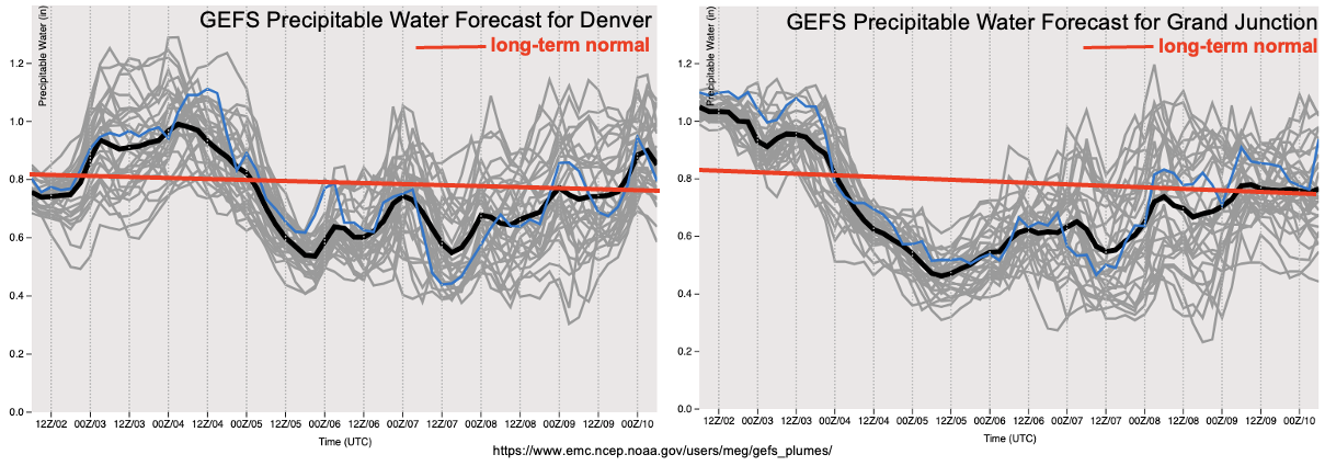
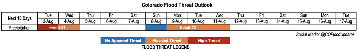
Each of the two identified precipitation events are described below.
Event #1: Tuesday – Wednesday (August 3 – August 4)
High Threat On Tuesday, Then Elevated Threat By Wednesday
Widespread moderate to heavy rainfall is expected over the higher terrain once again on Tuesday, shifting slightly east compared to Monday’s placement. We are expecting widespread amounts over 1 inch above 8,000 feet. Hourly rainfall intensity will not be particularly impressive, perhaps 1.0 inch/hour, but 3-6 hour totals approaching 2 inches warrant a High threat especially due to the existing saturated soils. By Wednesday, the moisture plume shifts southeast and the Southeast Mountains and Raton Ridge will likely see the bullseye of heavy precipitation. Up to 2 inches of rainfall is expected once again, though storm coverage will likely be slightly lower, hence the expected Elevated threat.
Event #2: Sunday – Wednesday (August 8 – August 11)
Low-end Elevated Threat Expected in Climatologically Favored Regions
After a lull of several days, PW is expected to once again exceed 1 inch over southern and central Colorado, leading to an uptick in storm coverage and rainfall intensity by this weekend. Daily rounds of showers and storms are expected in the San Juans, Central Mountains, Southeast Mountains and possibly Front Range. Up to 1.0 inch per hour in rainfall intensity appears possible, which would be enough in sustaining the threat of debris slides and mud flows over the higher terrain. The degree to which storms are able to persist east of the foothills is uncertain, but the best chance for this would be east of the Palmer Ridge, in consistency with climatology.