Issue Date: Thursday, August 5th, 2021
Issue Time: 2:50PM MDT
Valid Dates: 8/6 – 8/20

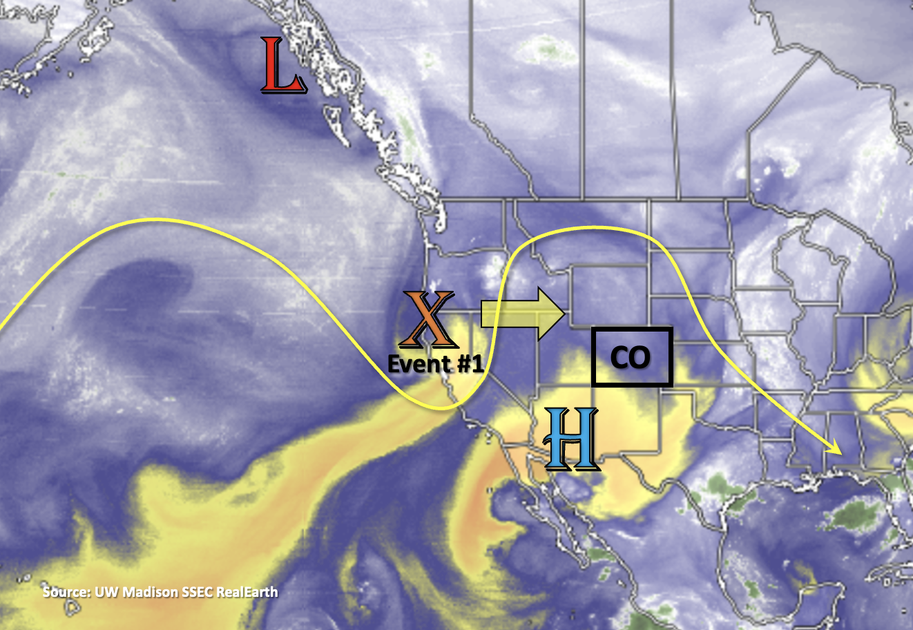
Finally, we’ve reached the long-awaited break in heavy rainfall activity as the axis of the ridge moves into an unfavorable position for a subtropical moisture surge over the state. Tomorrow, a quick-moving shortwave (orange “X”) moves across our northern border. As it passes, it should help spark some scattered storms over the mountains, which will likely spill into the adjacent plains by the afternoon and evening hours. However, with the dry west and northwesterly flow aloft over the state and not much surface moisture associated with the shortwave, the storms are not expected to produce a flood threat but more of a wind threat. The increase afternoon cloud cover and very modest rainfall for limited areas will be a nice break from the heat as high temperatures will run ~5 to 8 degF above average.

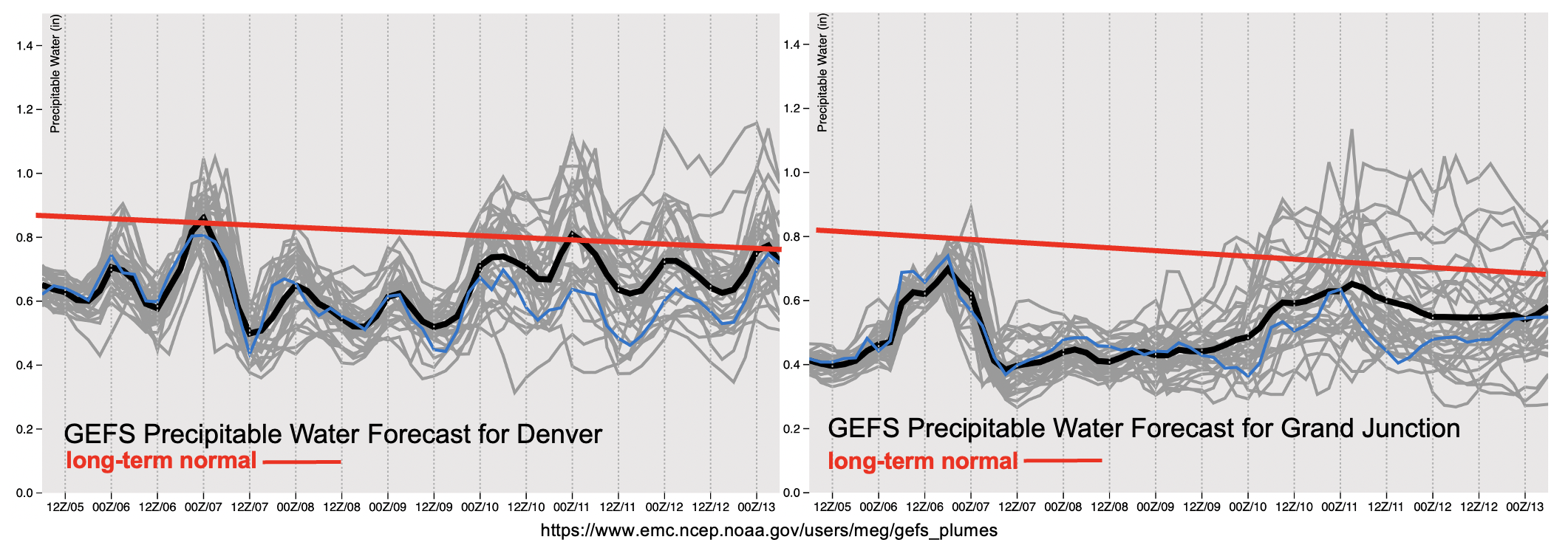
After Event #1, it should be fairly quiet the rest of the week with PW below normal for this time of year. Some showers and weak storms may still be possible over the mountains with the residual moisture, but it’s more likely we’ll only see afternoon, fair weather cumulus clouds and plenty of virga. Taking a look at the red solid lines below, you can see that we’ve started our downward trend in the long-term normal for PW. That doesn’t mean the heavy rainfall threat is over for the season, but climatologically over the next week or so, we typically see our monsoon season begin to wind down. The plumes do hint at a slight rise in PW by the end of end of next week, but the separation in the gray lines still show a lot of uncertainty in this forecast. The upward trend in PW indicates that this will be the next opportunity for a moisture surge not this weekend, but next weekend. An Elevated flood threat has been issued for this event, but it is very likely that the forecast could change given the uncertainty this far out. Be sure to tune into the FTO next week to keep tabs on the changes for Event #2.

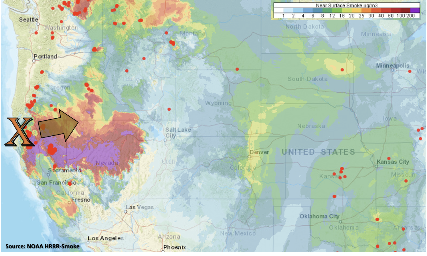
Below is the near surface smoke from the HRRR model with ongoing fires marked by the red dots. There is already some relatively thick near-surface smoke over the I-25 Corridor and eastern foothills with the integrated smoke (full atmospheric column) showing even higher concentrations (not pictured). The advection of smoke with the northwest flow is impacting visibility quite a bit today, and the air quality alert continues. So, the big “weather” feature over the next couple of days will be the wildfire smoke increasing across the state as the flow becomes more zonal with the approaching trough. Expect that big plume of near surface smoke (pink/red shades below) to arrive to western Colorado by tomorrow evening and eastern Colorado by Saturday morning. So although a dry and warm weekend is ahead, anticipate limited visibly.

Keep scrolling below to read a few more details about the events for this FTO.
Event #1: Friday (8/5)
No Apparent threat as scattered storms will likely develop over the mountains and produce more of a wind than heavy rainfall threat.
No map has been drawn below to the one-day event likely producing precipitation totals under 0.50 inches. Scattered storms are expected develop by early afternoon over the mountains and spill into the adjacent plains by late afternoon. Due to the drier air, storms will likely dissipate rather quickly and could produce some strong outflow winds. The increased mid-level lift from the vorticity maximum will help support this wind threat over the mountains as well. The tightening surface gradient is also forecast to produce higher surface winds over the Northwest Slope. Paired with low dew points (relative humidity) over the area there is an increase in fire danger over that region. So, a Red Flag Warning has been issued. Flooding is NOT expected with this event.
Event #2: Thursday – Sunday (8/12 – 8/15)
Next shot at a moderate monsoon moisture surge, so an Elevated flood threat is issued.
Quite a bit of uncertainty in an event this far out, and details will inevitably change. Between the northwesterly flow pushing disturbances through the state and a more active Pacific (hurricane season), there is a chance for an increase in moisture over the area. Extra dynamics could also be at play with mid-level energy likely moving through the flow during this period, so an Elevated flood threat has been issued. Chosen not to draw any maps due to the uncertainty of the forecast, but just wanted to look ahead to the next potential rainfall event.