FTO 09-02-2021: Elevated Flood Threat Early, Then Attention Turns To Wildfire Risk Next Week

Issue Date: Thursday, September 2nd, 2021
Issue Time: 1:15PM MDT
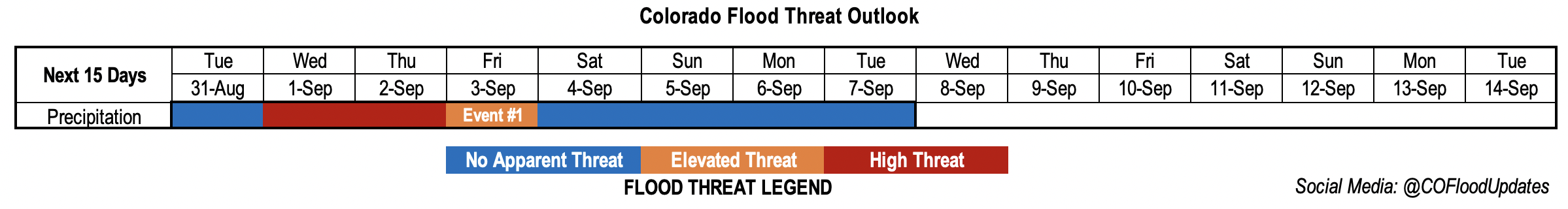
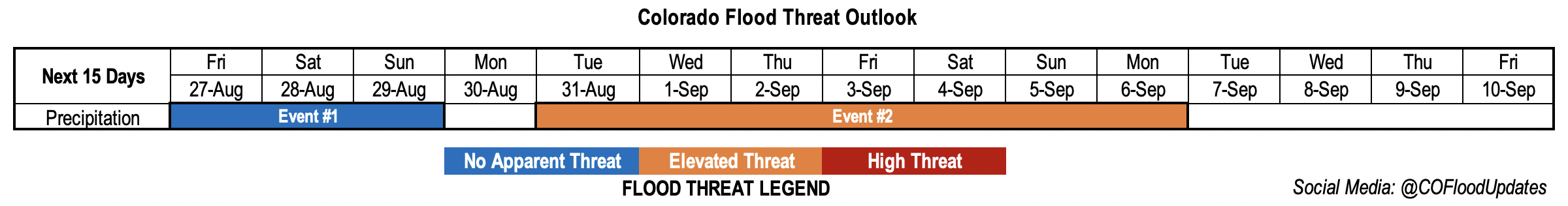
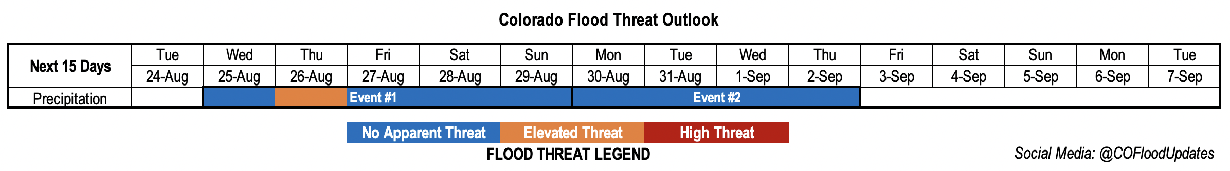
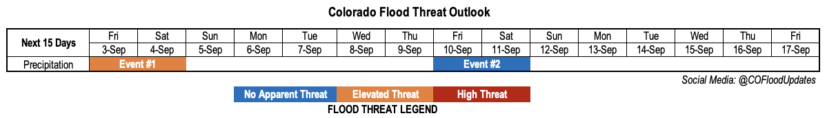
Valid Dates: 9/3-9/17

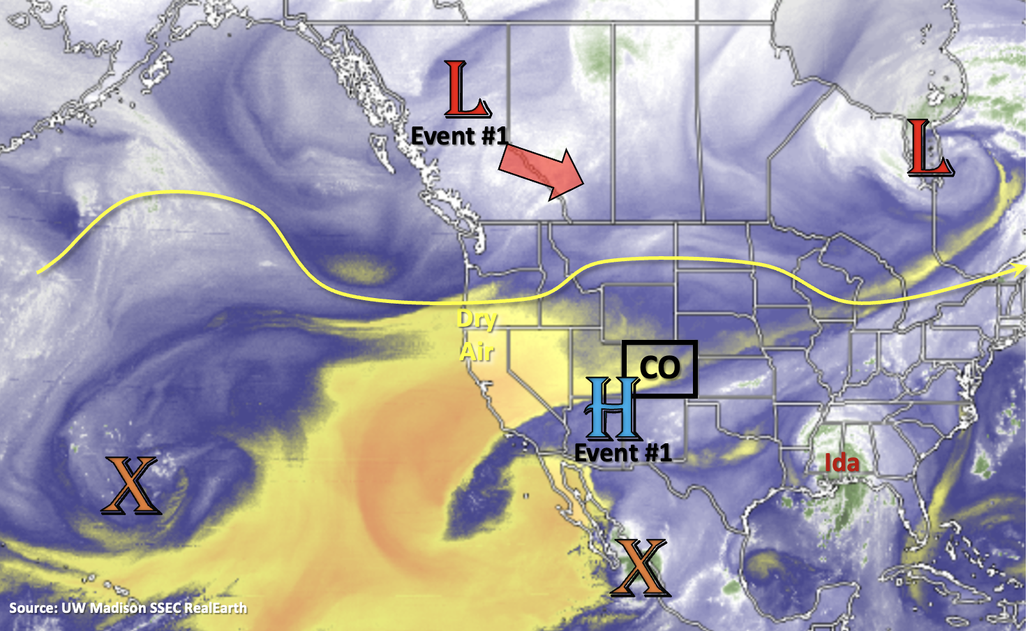
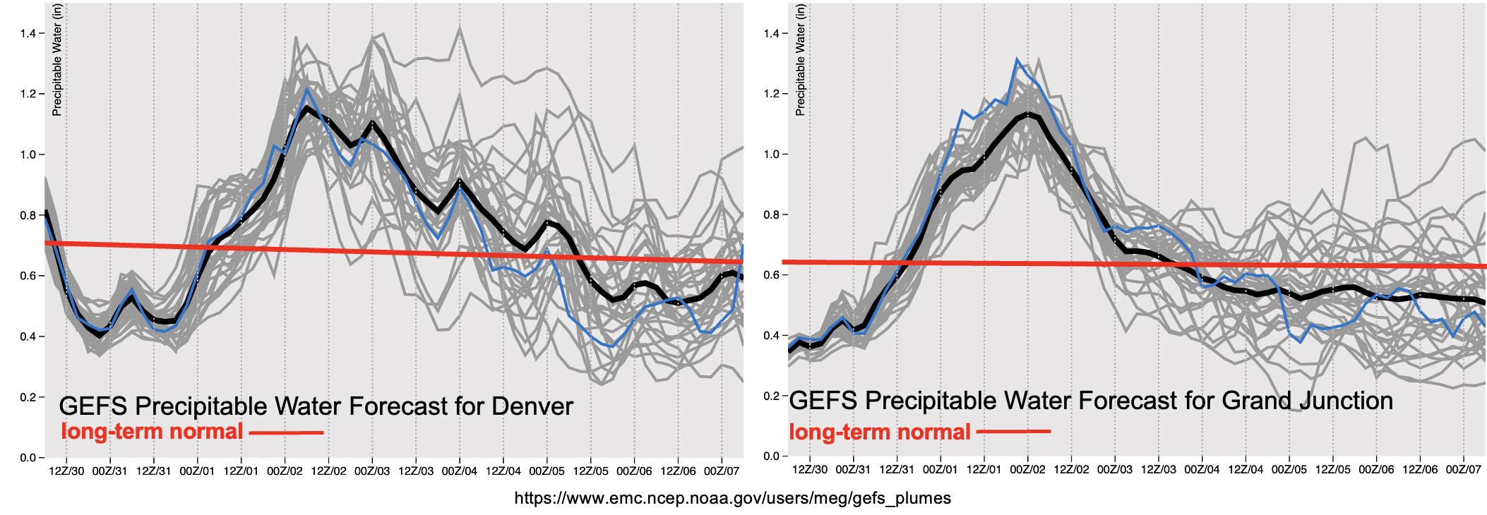
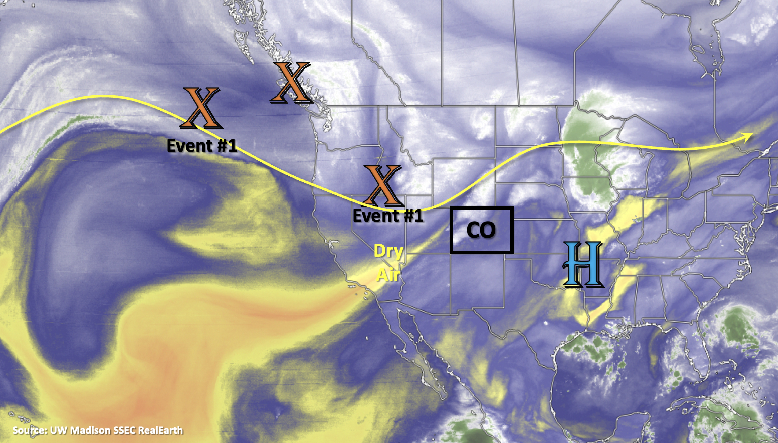
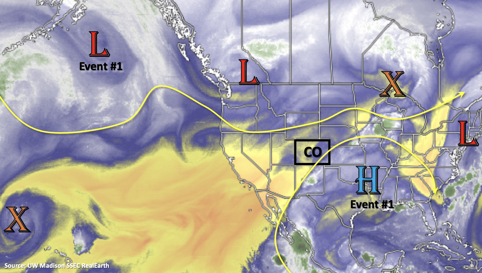
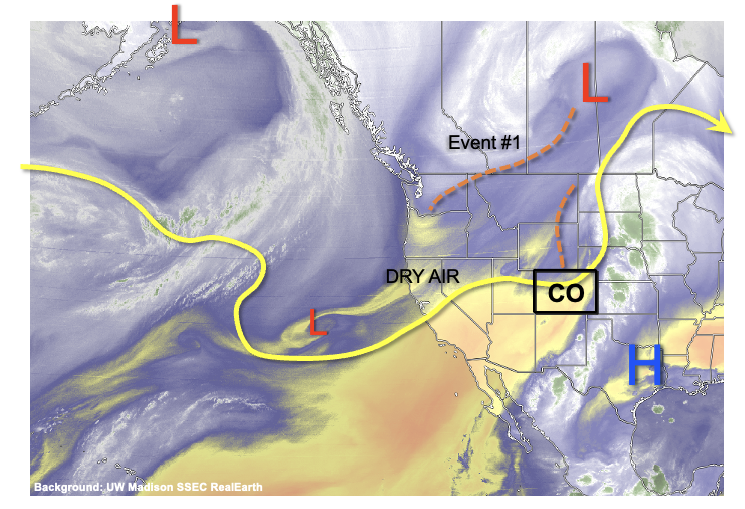
As shown in the water vapor image, below, Colorado is under the firm influence of a large-scale trough that is centered over west-central North America. Although dry air is beginning to infiltrate into western Colorado, significant moisture will continue to hold out over the eastern Plains leading to an interesting 48 hour period Friday-Saturday with a potential for heavy rainfall along with isolated severe weather. An Elevated Flood Threat is warranted for this event (Event #1). The main feature responsible for Event #1 is a shortwave trough currently located along the US/Canada border. As this feature moves southeast, a developing surface low wil support moist upslope flow over eastern Colorado, raising Precipitable Water (PW) to as high as 1.3 inches over the Arkansas River valley. This is significantly above the normal value of about 0.8-0.9 inches during early September. Key factors that will dictate the flood threat severity will be (i) extent of early morning cloud cover, and (ii) whether boundary layer moisture can hang around. At this time, it appears that at least isolated heavy rainfall, and the threat of flash flooding, is probable both Friday and Saturday. In addition, stronger winds moving in aloft will support a threat of severe weather, mainly in the form of large hail and damaging winds, although a tornado threat could also exist mainly along the NE/KS border counties.

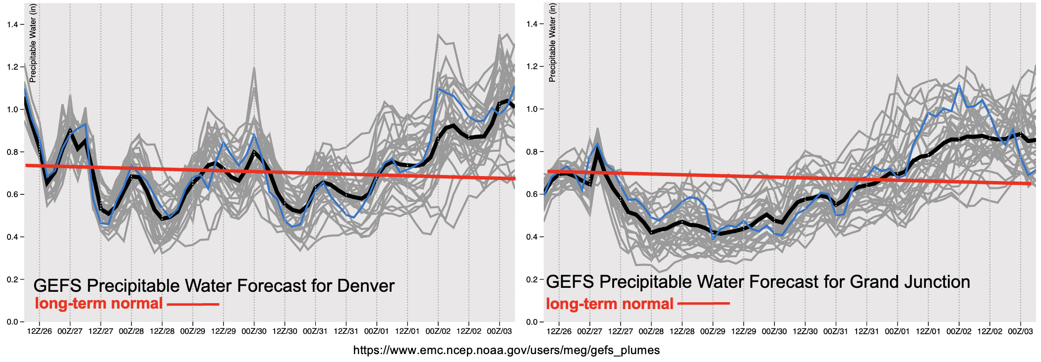
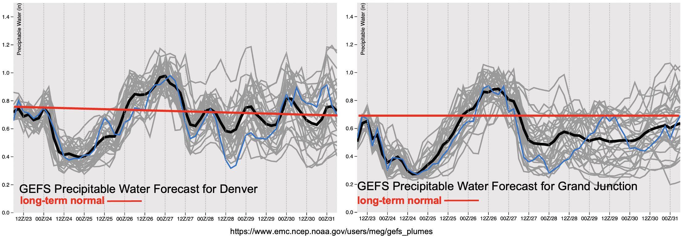
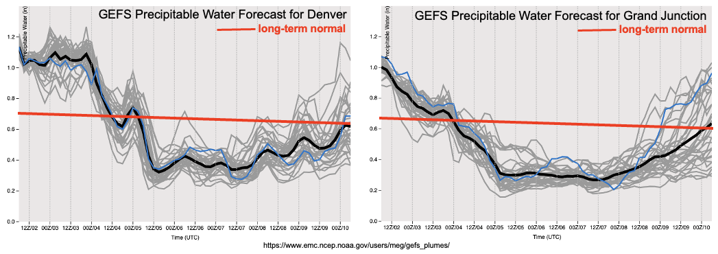
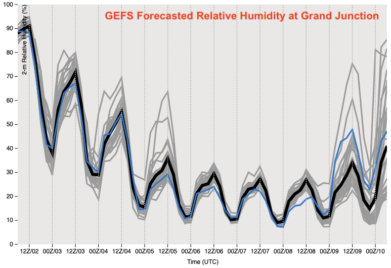
After the passage of Event #1, an abrupt shift back to a hot and extremely dry pattern looks likely beginning Sunday for western Colorado and spreading over the entire state by Monday. This is clearly depicted by forecasted PW plumes for both Denver and Grand Junction. PW is expected to drop into the 0.2-0.3 inch range across the state, which would be close to record low values for early September. Also shown below is the forecasted dewpoint temperatures at Grand Junction, which are expected to be below 20F during the afternoon hours from Sunday – Thursday. In addition, high temperatures are expected to hover near record levels at least during several afternoons as a strong ridge, and strong subsidence, develops just west of Colorado. Thus, several factors that support an enhanced wildfire threat will be met. Fortunately, soil moisture has just been replenished over the Western Slope so this will take a while to dry out. Additionally, wind speeds are currently not expected to be particularly strong, which is a positive sign. Nonetheless, the wildfire threat will certainly increase, as seems to be a recurring theme during the past few autumns across our state.

By late next week, guidance suggests a rebound in moisture for most of Colorado (Event #2). However, the mechanism by which this occurs is highly uncertain. Some guidance is suggesting a weak push of monsoonal moisture, while other guidance suggests a frontal passage or two. In either situation, less that 0.5 inches of precipitation is expected so there is No Apparent Flood Threat with Event #2 at this time.

The two identified precipitation events are described in more detail below.

Event #1: Friday – Saturday (September 3 – September 4)

Elevated Flood Threat, Including During The Overnight Hours, Mainly For Southeast Plains; Severe Weather Also Possible

An active period is expected for eastern Colorado during this event. Afternoon and evening showers and thunderstorms are likely on Friday, with the highest coverage along and just east of the three ridges: the Cheyenne Ridge, the Palmer Ridge and the Raton Ridge. Early activity could produce up to 1 inch per hour of rainfall. However, as storms organize into complexes by late afternoon and evening, heavier rainfall is expected towards the KS and NE border with up to 2.25 inches per hour possible. Isolated flash flooding will be possible with this intensity. Severe weather is also possible across most of eastern Colorado on Friday as sufficient wind shear overlaps with ample instability. Overnight storms are also a concern for the Southeast Plains on Friday night, where localized amounts up to 2.5 inches are possible.

By Saturday, rainfall activity will drop in coverage a bit, and shift south and east as dry air begins to infiltrate into northern Colorado. Isolated heavy rainfall still appears possible over the entire Arkansas River valley, mainly towards the KS border. Up to 2 inches per hour is possible, which could cause more isolated flash flooding.

Event #2: Friday – Saturday (September 10 – September 11)

Precipitation Chances To Return But No Apparent Flood Threat At This Time

After a prolonged dry stretch, rainfall chances look to return to Colorado, although the mechanism is uncertain at this time. Guidance suggests the possibility of both marginal monsoon moisture, as well as the possibility of frontal rain arriving from the north. In either situation, less than 0.5 inches of total precipitation is currently expected, so no precipitation map is needed.

FTO 08-30-2021: Late Season Monsoon Event Before Drying Trend

Issue Date: Monday, August 30th, 2021
Issue Time: 3PM MDT
Valid Dates: 8/31 – 9/14

A late season monsoon event is forecast to begin on Wednesday as the upper-level High/Low pattern paves the way for a subtropical moisture surge. For the most part, this will be a mountain rainfall event, although storms may spill into or develop over the adjacent eastern plains beginning on Thursday. Prior to the main moisture arriving on Wednesday to western CO, expect another day with hot temperatures. Above average temperatures are also forecast over eastern Colorado for the next couple of days before the cool down arrives. The set up for Event #1 begins tomorrow, as the High (marked below) begins to build northward. By tomorrow evening and into Wednesday the Low over Canada moves south and then east, which will push the center of the High over Texas/Oklahoma. With the ridge axis displaced to our east, an increase in south and southwesterly flow is forecast. This will first pull the moisture, that has been sitting south of our border, northward, and then, it will move across the western border on Wednesday. Some lighter rainfall may be possible tomorrow afternoon over western CO with the incoming jet, but with a dry surface layer, the main threat from the scattered storms that develop will be lightning and strong outflow winds.

As is typical for a monsoon surge, moisture will first arrive to the western border and then be pushed east. Widespread showers and rainfall are anticipated to reach the western border beginning on Wednesday morning with plenty of lift moving through the flow through Thursday. This extra lift should help increase the intensity of the storms throughout the day on Wednesday and increase the coverage of thunderstorms and rainfall on Wednesday and Thursday. With the subtropical jet overhead, PW quickly climbs to above 1 inch over Grand Junction, which means that heavy rainfall will likely accompany the storms over the region on Wednesday and Thursday. PW then begins to rapidly rise over eastern CO as the moisture arrives on Thursday, and it remains elevated over the region through Friday. A HIGH/ELEVATED flood threat has been issued for this period. Dry air quickly moves in behind the system, so expect a rapid drop off in storm coverage beginning on Friday (west) and Saturday (east). Scattered to isolated mountain storms will be likely through the beginning of next week and with the residual moisture and some storms may develop over the eastern plains, but there is No Apparent flood threat.

Scroll down below to read more details about this event.

Event #1: TuesdayTuesday (8/319/7)

A late season monsoon surge will cause a HIGH/ELEVATED flood threat to be issued for Wednesday into Friday.

Best chance for flood issues, especially over recent burn areas, will be on Wednesday (west) and Thursday/Friday (east). There are two limiting factors to the flood threat for this event. The first is that instability may be limited with ongoing showers from Wednesday morning into Thursday. This could cause a downtick in afternoon thunderstorm develop (higher rainfall rates) and cause rainfall to be more stratiform in nature (lower rainfall rates). The second is that faster steering flows are anticipated with the subtropical jet overhead, which should limit the flood threat from any individual storm. However, with the abundance of lift and moisture over the mountains, where training storms or longer duration precipitation can develop, the flood threat will increase. Thus, the three day HIGH/ELEVATED flood threat. Antecedent moisture, possible development of pockets of instability and the potential for training or long duration rainfall will all be tracked more closely in the daily FTB. So, be sure to tune in for the finer details of this event as it unfolds.

FTO 08-26-2021: Isolated to Scattered Mountain Storms Over the Weekend

Issue Date: Thursday, August 26th, 2021
Issue Time: 3PM MDT
Valid Dates: 8/27 – 9/10

A general troughing pattern with a few shortwaves moving through the flow will help to produce isolated to scattered storms over the weekend (Event #1). However, this pattern should promote more westerly flow aloft, which will likely decrease the overall available moisture for storms and in turn, reduce the flood threat. For the most part, measurable rainfall should be confined to the mountains, and with the near surface moisture lacking, accumulations should be on the lower end. A quick moving cold front on Saturday could produce some stronger storms over the plains, if they can break the cap, and help with more widespread storm coverage Sunday over the eastern mountains. This scenario on Sunday would likely only occur if there was decent moisture return behind the front. More on that in the next section.

There will be a slight break in rainfall on Sunday/Monday as the dry air marked below moves into western, then eastern Colorado. Heading into Tuesday, the ridge begins to re-build over the state. A deepening trough to our northwest and a potential land-falling hurricane to our southeast could generate strong and sustained south/southeast flow across the state, which would pull sub-tropical moisture northward. The potential for this late season monsoon surge is looking more likely at this time, although there is still a lot of uncertainty around the amount of moisture and how far north it would travel.

There’s No Apparent flood threat for Event #1 as PW drops both east and west after today. Another accumulation inhibitor will be faster steering flows with the jet sitting at the base of the trough. Better chance for rainfall accumulation during this event will be south, closer to the moisture rotating around the High. Over eastern Colorado there is a slight bump in moisture behind that previously mentioned front, but even with PW at near average values, the flood threat remains low. Best chance for a flood threat would be over a small area of the far eastern plains on Saturday, which will depend a lot on the timing of the frontal passage. Overall, for Event #1 the main threats from the scattered storms will be gusty outflow winds and dangerous lightning.

The PW images above do show an upward trend in values starting on Sunday with well-above average PW east and west by Thursday. The NAEFS (GEFS and GEPS) show PW values reaching from about 1 to up to 1.6 standard deviations above normal for Event #2. Equally, the EPS has been consistently picking up on this event over the last couple of days. With the potential for this one last monsoon surge, in what has been a long and robust season, an Elevated flood threat has been issued. Scroll below for more details about each event in this FTO.

Event #1: Friday – Sunday (8/27 – 8/29)

No Apparent flood threat for isolated to scattered, diurnal driven storms over the mountains and Northeast Plains for the weekend.

Storms on Friday will most likely occur over the southern Southeast and San Juan Mountains where there is a bit more residual moisture. On Saturday, storms coverage may pick up over the Front Range and Palmer Ridge in addition to another round of storms over the southern high terrains. There is the possibility for a couple stronger storms out east along the front, depending on when the front moves through on Saturday. So as far as the flood threat for FTB, this will be what we watch for Event #1. Sunday, it will be much cooler behind the front over eastern Colorado. More widespread storms over the eastern mountains will be possible in this post-front upslope flow scenario, as long as the atmosphere isn’t too stable.

Event #2: TuesdayMonday (8/319/6)

Late season moisture surge looking more likely, so an Elevated flood threat is issued.

Like before, there is still a lot of uncertainty in the forecast this far out in regard to moisture amount and northward movement of the sub-tropical moisture. However, with all guidance consistently indicating a late season monsoon surge, it is worth putting out an Elevated flood threat. The precipitation map below is a combination of output from guidance and climatology. This looks like it will mostly be a western Colorado event, which is excellent for the ongoing drought. Late season events such as this are also good before we move into a more typically dry period in September. The highest peaks may end up seeing a dusting of snow, but for the most part, it looks like a rainfall event. More to come next week, so be sure to tune back in on Monday afternoon.

FTO 08-23-2021: Hot Temperatures Continue & Uptick in Rainfall Chances by Mid-Week

Issue Date: Monday, August 23rd, 2021
Issue Time: 2:35PM MDT
Valid Dates: 8/24 – 9/7

We still have at least another dry day ahead of us before showers and storms return to the state on Wednesday, and especially Thursday. Hot temperatures are also forecast to continue, and near daily record values are possible over Colorado Springs and Alamosa tomorrow and Wednesday, respectively. There should also be a slight cool down statewide on Thursday as the next well-defined shortwave moves across the state (Event #1). Due to the extra dynamics and increase in moisture over the state on Thursday, there will be a one-day peak in the flood threat. With the troughing pattern holding on through the weekend, scattered storms are anticipated each afternoon over the mountains with the best chance for accumulation over the south and central mountains near the Continental Divide.

There’s a slingshot in moisture availability from the beginning of this week to mid-week, which can be seen in both the PW forecasts below. During this initial dry period, fire weather over the Northwest Slope and Northern Mountains is a concern. A Red Flag Warning has been issued on Tuesday for the Northwest Slope. Dry WSW flow loft will become more moisture-rich as an active tropical season and strengthening upper-level High begin to pull moisture northward beginning on Wednesday. Initially, the dry boundary layer will likely limit rainfall rates and produce some gusty outflow winds. However, by Thursday, rainfall efficiency is expected to increase and extra dynamics from the passing shortwave will help to spark more numerous and stronger thunderstorms. A one-day Elevated flood threat has been issued for this reason. Slightly faster steering flows are forecast from a jet associated with the approaching trough, so the flood threat should be limited in coverage if one is issued. For Friday and over the weekend, more average PW is likely, so expect your typical diurnal flow storms favoring the southern and central mountains for accumulations for this event. There is No Apparent Flood threat for this period. There’s an outside chance for a few storms over the Southeast Plains during Event #1, but the daily chance for precipitation will depend on the combination of moisture and lift availability.

Keep scrolling for more information about Event #1 and #2 below.

Event #1: WednesdaySunday (8/25 – 8/29)

Elevated/No Apparent threat as the next trough moves through and hangs around through the weekend.

Mentioned a lot of the details for this event above. Initially, on Wednesday, scattered storms should be confined to the mountains, although there is a chance for some storms over the Southeast Plains as well. Depending on the speed of the trough’s movement, there could be some overnight showers across the western border. More intense rainfall is forecast for Thursday with the main shortwave arriving. Thunderstorms will develop with this feature over the mountains (west) and move east through the day and into the evening hours. Higher moisture will increase the flood threat during this period, but fasting moving storms should limit the flood threat over any one area. Friday and Saturday, the best chance for rainfall looks to be over the southern mountains. Higher accumulations are anticipated south near the moisture source and mid-level lift. There is a chance for some additional storm coverage over the adjacent eastern plains (south). Sunday, storms should mostly be over the central and southern mountains. Precipitation totals should be limited to around 0.50-0.75 inches each day, so there is No Apparent Flood threat for this period.

Event #2: Monday – Thursday (8/30 – 9/2)

Late season moisture surge? At this time, there is No Apparent flood threat.

There’s an interesting (potential) set up for next week due to an increase in tropical activity (Event #2). Both the EPS and GEFS show a late season moisture surge that begins west before spreading east by the end of the week. Still a lot of uncertainty in the forecast this far out, but it could be another good soaking for the western portion of the state and mountains. At this time, it looks like there would be a prolonged period of rainfall, which could help temper the flood threat by limiting the amount of instability that can build. However, higher local accumulations over a 6-hour period could be possible depending on the moisture, which is the big question. Be sure to stay tuned to the FTO this Thursday and next week as the forecast details will likely be modified. Due to high uncertainty, no precipitation map has been drawn for this event.