Issue Date: Monday, August 30th, 2021
Issue Time: 3PM MDT
Valid Dates: 8/31 – 9/14
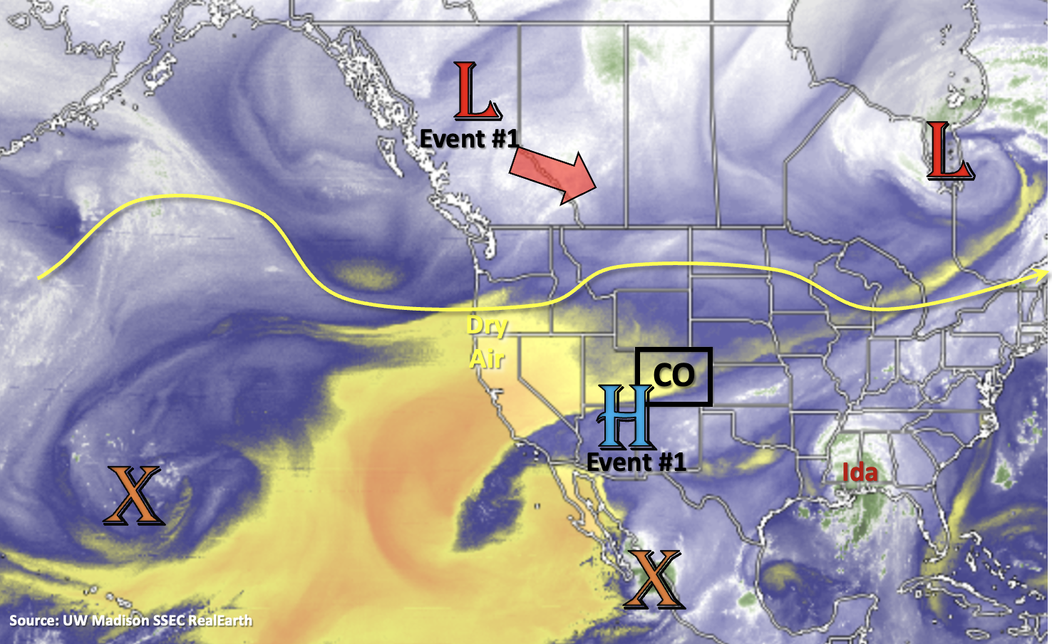
A late season monsoon event is forecast to begin on Wednesday as the upper-level High/Low pattern paves the way for a subtropical moisture surge. For the most part, this will be a mountain rainfall event, although storms may spill into or develop over the adjacent eastern plains beginning on Thursday. Prior to the main moisture arriving on Wednesday to western CO, expect another day with hot temperatures. Above average temperatures are also forecast over eastern Colorado for the next couple of days before the cool down arrives. The set up for Event #1 begins tomorrow, as the High (marked below) begins to build northward. By tomorrow evening and into Wednesday the Low over Canada moves south and then east, which will push the center of the High over Texas/Oklahoma. With the ridge axis displaced to our east, an increase in south and southwesterly flow is forecast. This will first pull the moisture, that has been sitting south of our border, northward, and then, it will move across the western border on Wednesday. Some lighter rainfall may be possible tomorrow afternoon over western CO with the incoming jet, but with a dry surface layer, the main threat from the scattered storms that develop will be lightning and strong outflow winds.
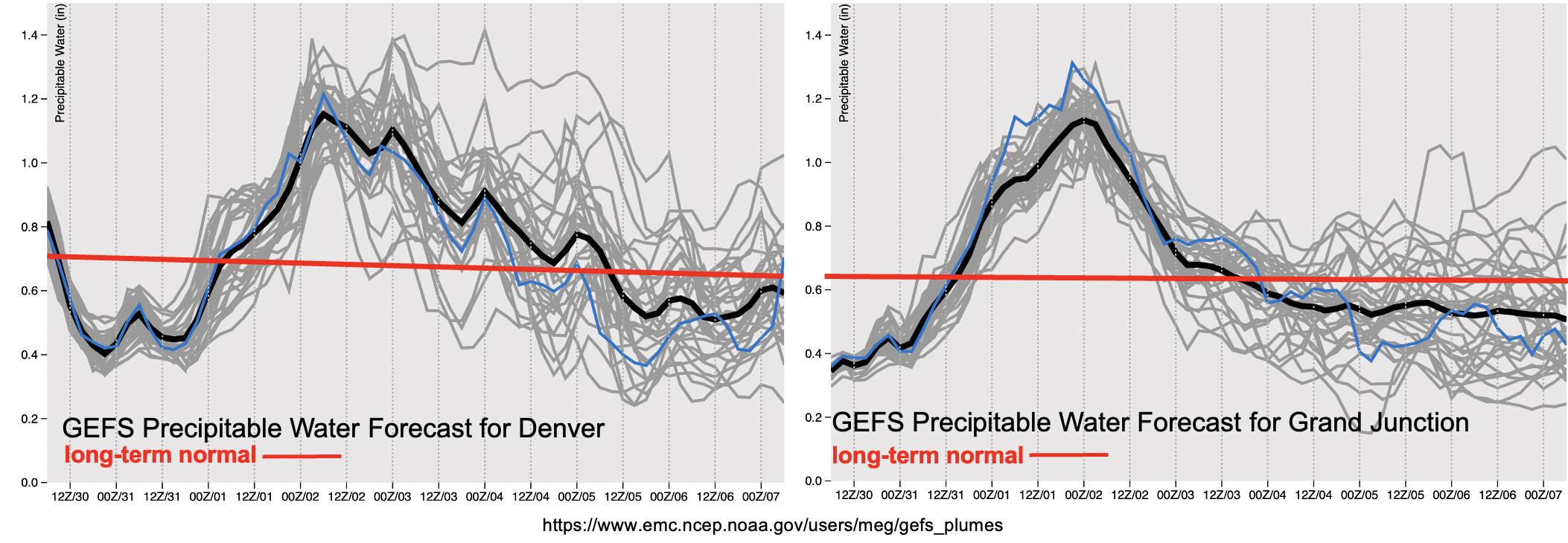
As is typical for a monsoon surge, moisture will first arrive to the western border and then be pushed east. Widespread showers and rainfall are anticipated to reach the western border beginning on Wednesday morning with plenty of lift moving through the flow through Thursday. This extra lift should help increase the intensity of the storms throughout the day on Wednesday and increase the coverage of thunderstorms and rainfall on Wednesday and Thursday. With the subtropical jet overhead, PW quickly climbs to above 1 inch over Grand Junction, which means that heavy rainfall will likely accompany the storms over the region on Wednesday and Thursday. PW then begins to rapidly rise over eastern CO as the moisture arrives on Thursday, and it remains elevated over the region through Friday. A HIGH/ELEVATED flood threat has been issued for this period. Dry air quickly moves in behind the system, so expect a rapid drop off in storm coverage beginning on Friday (west) and Saturday (east). Scattered to isolated mountain storms will be likely through the beginning of next week and with the residual moisture and some storms may develop over the eastern plains, but there is No Apparent flood threat.
Scroll down below to read more details about this event.
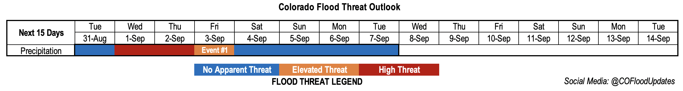
Event #1: Tuesday – Tuesday (8/31 – 9/7)
A late season monsoon surge will cause a HIGH/ELEVATED flood threat to be issued for Wednesday into Friday.
Best chance for flood issues, especially over recent burn areas, will be on Wednesday (west) and Thursday/Friday (east). There are two limiting factors to the flood threat for this event. The first is that instability may be limited with ongoing showers from Wednesday morning into Thursday. This could cause a downtick in afternoon thunderstorm develop (higher rainfall rates) and cause rainfall to be more stratiform in nature (lower rainfall rates). The second is that faster steering flows are anticipated with the subtropical jet overhead, which should limit the flood threat from any individual storm. However, with the abundance of lift and moisture over the mountains, where training storms or longer duration precipitation can develop, the flood threat will increase. Thus, the three day HIGH/ELEVATED flood threat. Antecedent moisture, possible development of pockets of instability and the potential for training or long duration rainfall will all be tracked more closely in the daily FTB. So, be sure to tune in for the finer details of this event as it unfolds.