Issue Date: Thursday, September 2nd, 2021
Issue Time: 1:15PM MDT
Valid Dates: 9/3-9/17
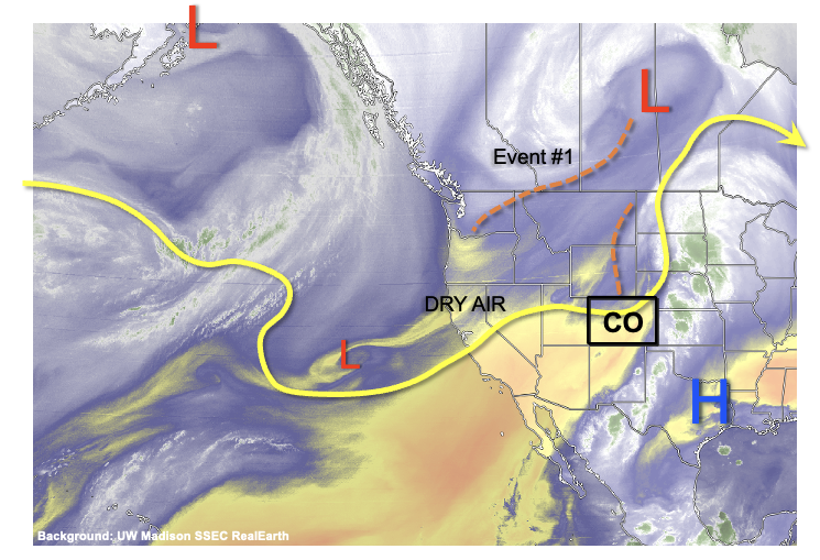
As shown in the water vapor image, below, Colorado is under the firm influence of a large-scale trough that is centered over west-central North America. Although dry air is beginning to infiltrate into western Colorado, significant moisture will continue to hold out over the eastern Plains leading to an interesting 48 hour period Friday-Saturday with a potential for heavy rainfall along with isolated severe weather. An Elevated Flood Threat is warranted for this event (Event #1). The main feature responsible for Event #1 is a shortwave trough currently located along the US/Canada border. As this feature moves southeast, a developing surface low wil support moist upslope flow over eastern Colorado, raising Precipitable Water (PW) to as high as 1.3 inches over the Arkansas River valley. This is significantly above the normal value of about 0.8-0.9 inches during early September. Key factors that will dictate the flood threat severity will be (i) extent of early morning cloud cover, and (ii) whether boundary layer moisture can hang around. At this time, it appears that at least isolated heavy rainfall, and the threat of flash flooding, is probable both Friday and Saturday. In addition, stronger winds moving in aloft will support a threat of severe weather, mainly in the form of large hail and damaging winds, although a tornado threat could also exist mainly along the NE/KS border counties.
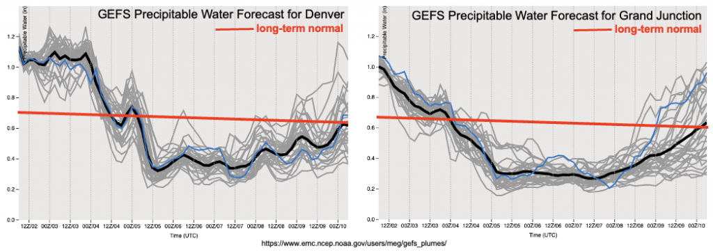
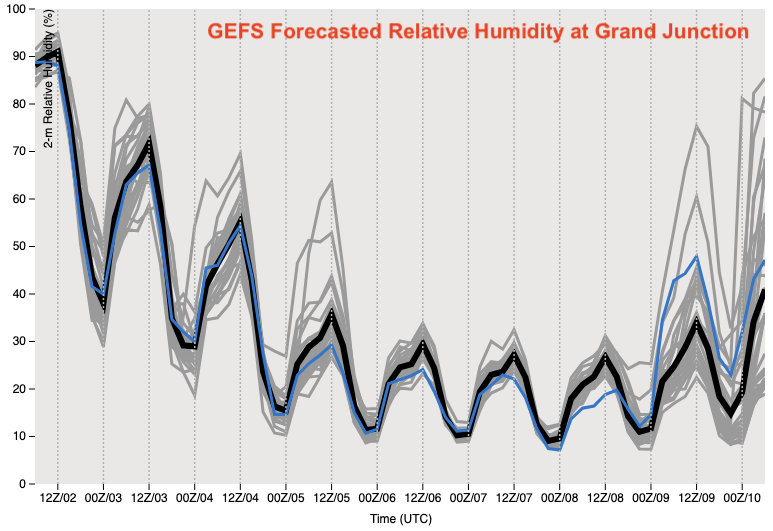
After the passage of Event #1, an abrupt shift back to a hot and extremely dry pattern looks likely beginning Sunday for western Colorado and spreading over the entire state by Monday. This is clearly depicted by forecasted PW plumes for both Denver and Grand Junction. PW is expected to drop into the 0.2-0.3 inch range across the state, which would be close to record low values for early September. Also shown below is the forecasted dewpoint temperatures at Grand Junction, which are expected to be below 20F during the afternoon hours from Sunday – Thursday. In addition, high temperatures are expected to hover near record levels at least during several afternoons as a strong ridge, and strong subsidence, develops just west of Colorado. Thus, several factors that support an enhanced wildfire threat will be met. Fortunately, soil moisture has just been replenished over the Western Slope so this will take a while to dry out. Additionally, wind speeds are currently not expected to be particularly strong, which is a positive sign. Nonetheless, the wildfire threat will certainly increase, as seems to be a recurring theme during the past few autumns across our state.
By late next week, guidance suggests a rebound in moisture for most of Colorado (Event #2). However, the mechanism by which this occurs is highly uncertain. Some guidance is suggesting a weak push of monsoonal moisture, while other guidance suggests a frontal passage or two. In either situation, less that 0.5 inches of precipitation is expected so there is No Apparent Flood Threat with Event #2 at this time.
The two identified precipitation events are described in more detail below.
Event #1: Friday – Saturday (September 3 – September 4)
Elevated Flood Threat, Including During The Overnight Hours, Mainly For Southeast Plains; Severe Weather Also Possible
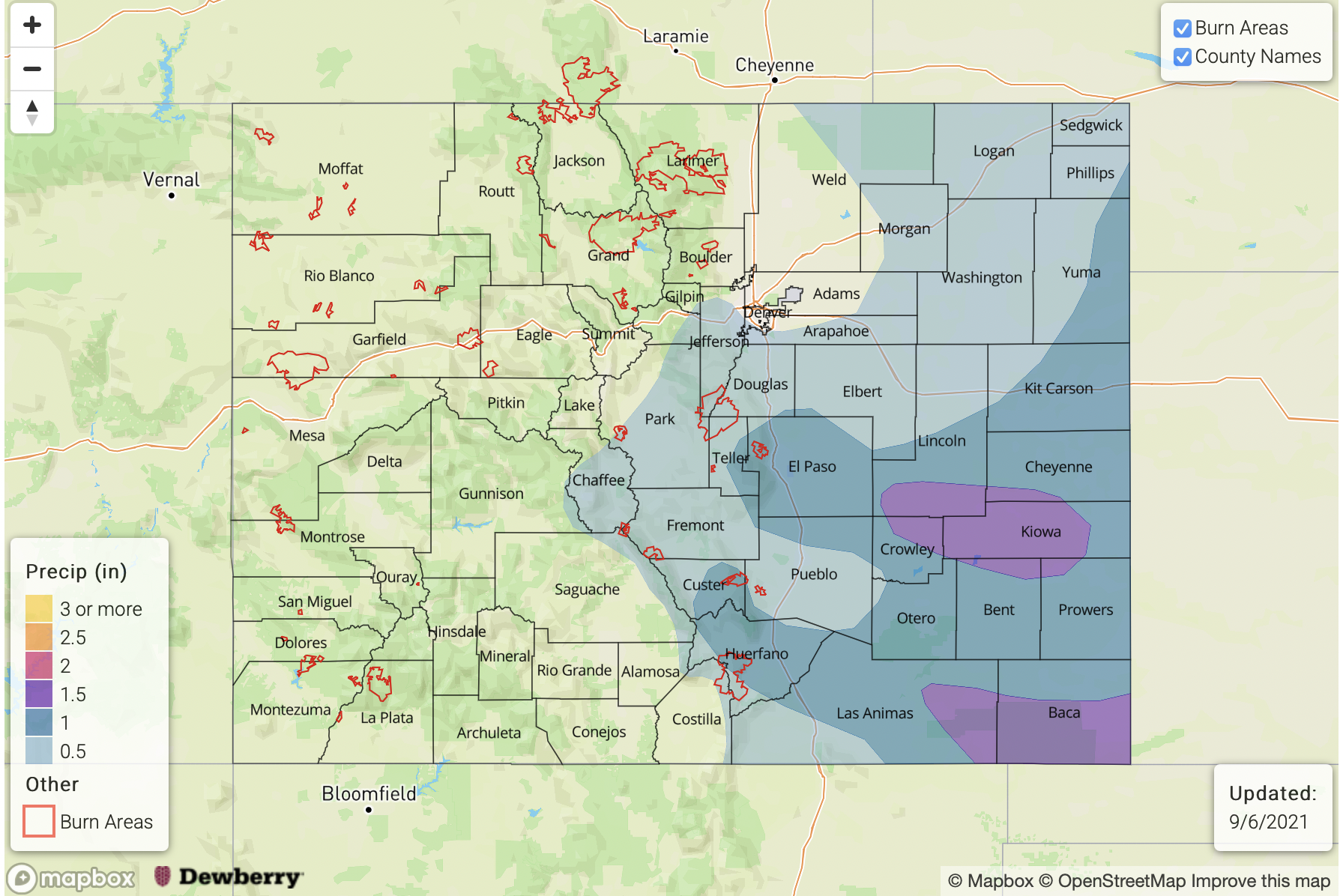
An active period is expected for eastern Colorado during this event. Afternoon and evening showers and thunderstorms are likely on Friday, with the highest coverage along and just east of the three ridges: the Cheyenne Ridge, the Palmer Ridge and the Raton Ridge. Early activity could produce up to 1 inch per hour of rainfall. However, as storms organize into complexes by late afternoon and evening, heavier rainfall is expected towards the KS and NE border with up to 2.25 inches per hour possible. Isolated flash flooding will be possible with this intensity. Severe weather is also possible across most of eastern Colorado on Friday as sufficient wind shear overlaps with ample instability. Overnight storms are also a concern for the Southeast Plains on Friday night, where localized amounts up to 2.5 inches are possible.
By Saturday, rainfall activity will drop in coverage a bit, and shift south and east as dry air begins to infiltrate into northern Colorado. Isolated heavy rainfall still appears possible over the entire Arkansas River valley, mainly towards the KS border. Up to 2 inches per hour is possible, which could cause more isolated flash flooding.
Event #2: Friday – Saturday (September 10 – September 11)
Precipitation Chances To Return But No Apparent Flood Threat At This Time
After a prolonged dry stretch, rainfall chances look to return to Colorado, although the mechanism is uncertain at this time. Guidance suggests the possibility of both marginal monsoon moisture, as well as the possibility of frontal rain arriving from the north. In either situation, less than 0.5 inches of total precipitation is currently expected, so no precipitation map is needed.


