Issue Date: Monday, August 23rd, 2021
Issue Time: 2:35PM MDT
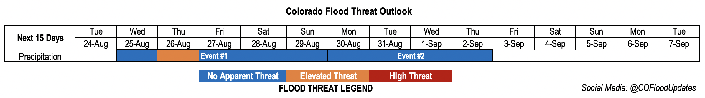
Valid Dates: 8/24 – 9/7
We still have at least another dry day ahead of us before showers and storms return to the state on Wednesday, and especially Thursday. Hot temperatures are also forecast to continue, and near daily record values are possible over Colorado Springs and Alamosa tomorrow and Wednesday, respectively. There should also be a slight cool down statewide on Thursday as the next well-defined shortwave moves across the state (Event #1). Due to the extra dynamics and increase in moisture over the state on Thursday, there will be a one-day peak in the flood threat. With the troughing pattern holding on through the weekend, scattered storms are anticipated each afternoon over the mountains with the best chance for accumulation over the south and central mountains near the Continental Divide.
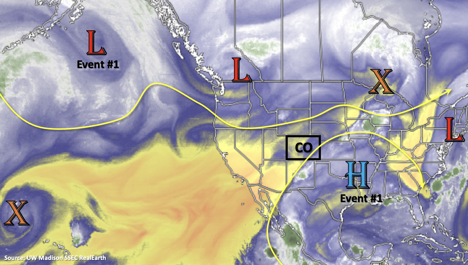
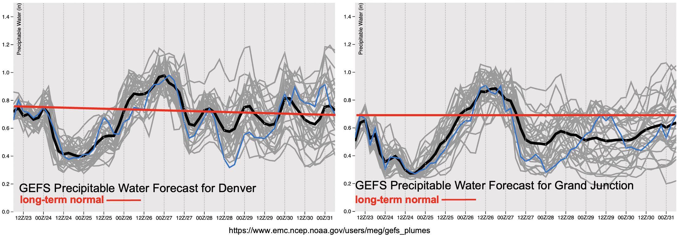
There’s a slingshot in moisture availability from the beginning of this week to mid-week, which can be seen in both the PW forecasts below. During this initial dry period, fire weather over the Northwest Slope and Northern Mountains is a concern. A Red Flag Warning has been issued on Tuesday for the Northwest Slope. Dry WSW flow loft will become more moisture-rich as an active tropical season and strengthening upper-level High begin to pull moisture northward beginning on Wednesday. Initially, the dry boundary layer will likely limit rainfall rates and produce some gusty outflow winds. However, by Thursday, rainfall efficiency is expected to increase and extra dynamics from the passing shortwave will help to spark more numerous and stronger thunderstorms. A one-day Elevated flood threat has been issued for this reason. Slightly faster steering flows are forecast from a jet associated with the approaching trough, so the flood threat should be limited in coverage if one is issued. For Friday and over the weekend, more average PW is likely, so expect your typical diurnal flow storms favoring the southern and central mountains for accumulations for this event. There is No Apparent Flood threat for this period. There’s an outside chance for a few storms over the Southeast Plains during Event #1, but the daily chance for precipitation will depend on the combination of moisture and lift availability.
Keep scrolling for more information about Event #1 and #2 below.
Event #1: Wednesday – Sunday (8/25 – 8/29)
Elevated/No Apparent threat as the next trough moves through and hangs around through the weekend.
Mentioned a lot of the details for this event above. Initially, on Wednesday, scattered storms should be confined to the mountains, although there is a chance for some storms over the Southeast Plains as well. Depending on the speed of the trough’s movement, there could be some overnight showers across the western border. More intense rainfall is forecast for Thursday with the main shortwave arriving. Thunderstorms will develop with this feature over the mountains (west) and move east through the day and into the evening hours. Higher moisture will increase the flood threat during this period, but fasting moving storms should limit the flood threat over any one area. Friday and Saturday, the best chance for rainfall looks to be over the southern mountains. Higher accumulations are anticipated south near the moisture source and mid-level lift. There is a chance for some additional storm coverage over the adjacent eastern plains (south). Sunday, storms should mostly be over the central and southern mountains. Precipitation totals should be limited to around 0.50-0.75 inches each day, so there is No Apparent Flood threat for this period.
Event #2: Monday – Thursday (8/30 – 9/2)
Late season moisture surge? At this time, there is No Apparent flood threat.
There’s an interesting (potential) set up for next week due to an increase in tropical activity (Event #2). Both the EPS and GEFS show a late season moisture surge that begins west before spreading east by the end of the week. Still a lot of uncertainty in the forecast this far out, but it could be another good soaking for the western portion of the state and mountains. At this time, it looks like there would be a prolonged period of rainfall, which could help temper the flood threat by limiting the amount of instability that can build. However, higher local accumulations over a 6-hour period could be possible depending on the moisture, which is the big question. Be sure to stay tuned to the FTO this Thursday and next week as the forecast details will likely be modified. Due to high uncertainty, no precipitation map has been drawn for this event.