FTO 05-26-2022: Cool and Very Active Pattern But Limited Flood Threat, For Now

Issue Date: Thursday, May 26th, 2022
Issue Time: 3PM MDT
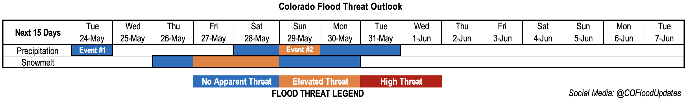
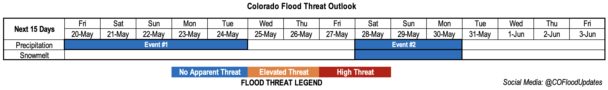
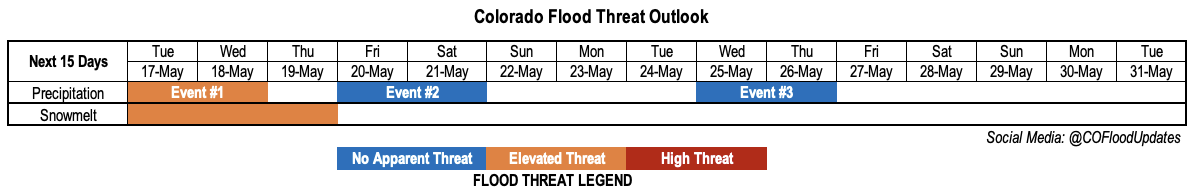
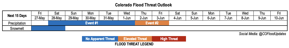
Valid Dates: 5/27-6/10

NOTE: Unless conditions warrant, the next Flood Threat Outlook will be released on Tuesday, May 31st. Flood Threat Bulletins will continue to be issued daily over the Memorial Day weekend.

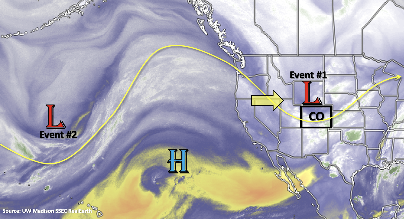
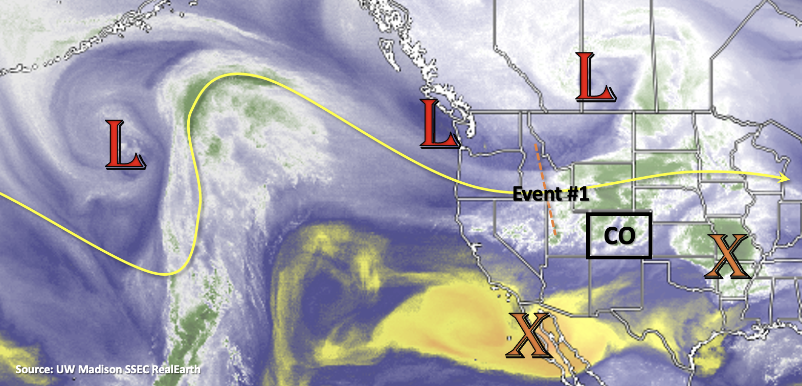
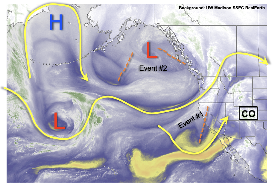
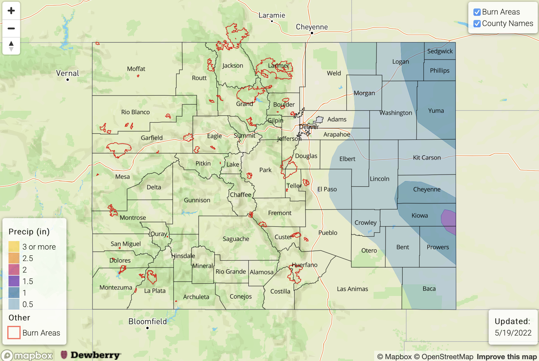
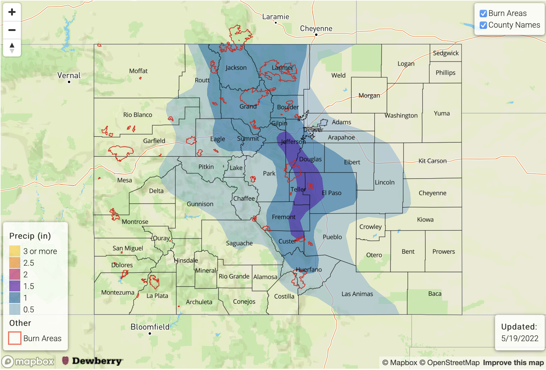
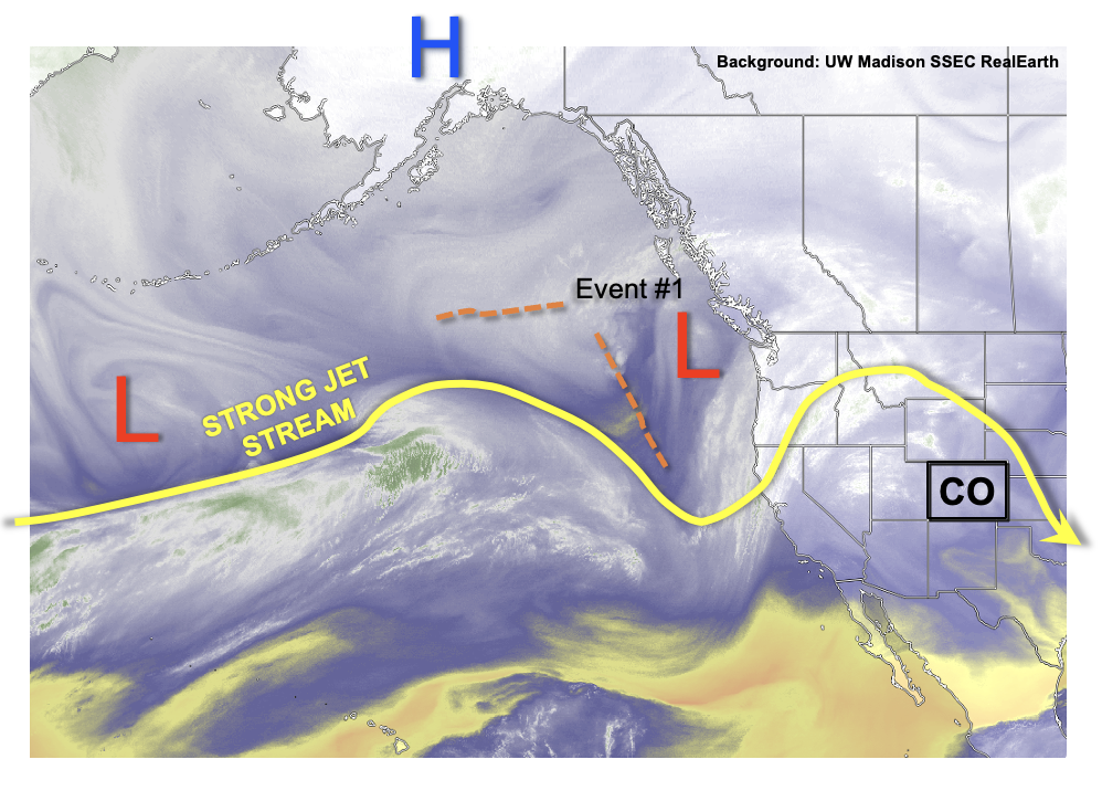
For central and northern Colorado, it seems that Mother Nature heard all of our griping about the dusty, dry and windy April. Over the next week or so, as shown in the water vapor image, below, a strong jet stream will continue to favor troughs and/or cut-off disturbances over Colorado. With the availability of moisture continuing its seasonal ascent, this will continue to favor scattered to widespread precipitation beginning late Saturday and into the middle of next week (Event #1). After a brief 48-hour warm-up, the other major story will be the continued below normal temperatures that will persist statewide, but especially over the central and western areas. Overall, all but southwest Colorado is expected to see beneficial precipitation from Event #1. The good news for the Southwest Slope is that cooler conditions should somewhat temper the fire threat.

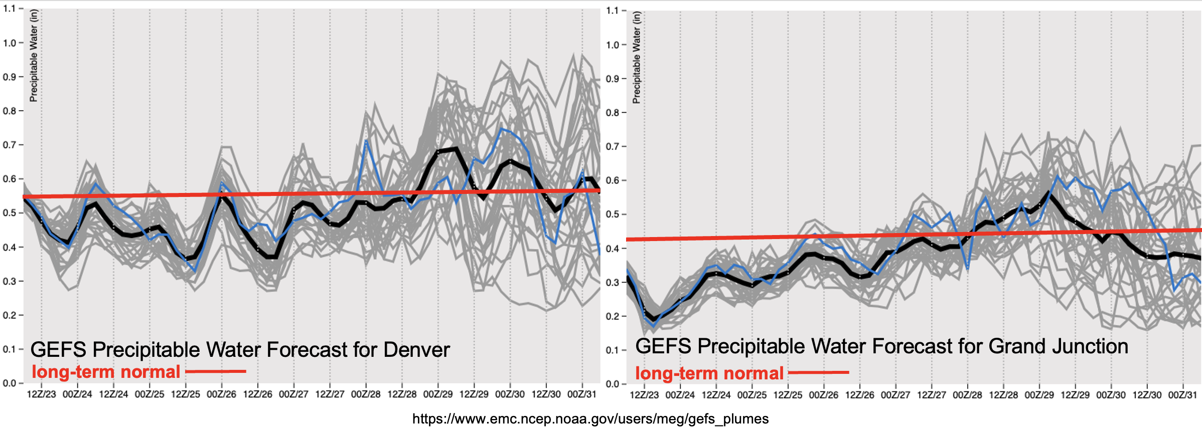
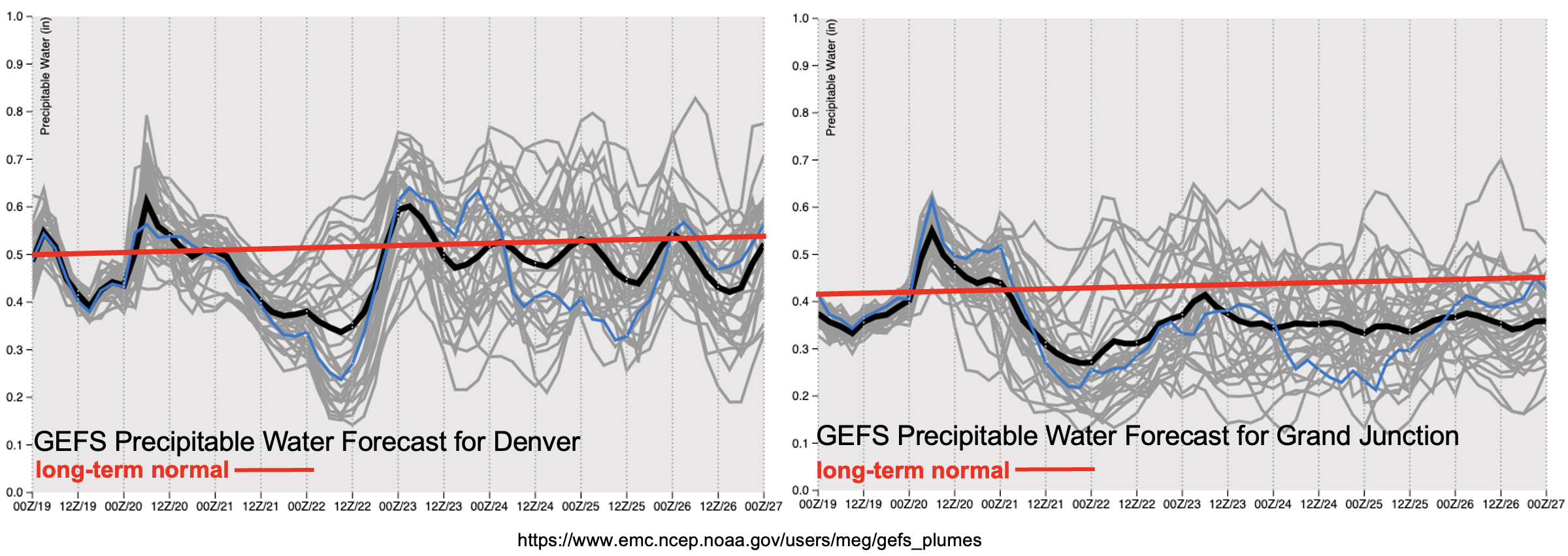
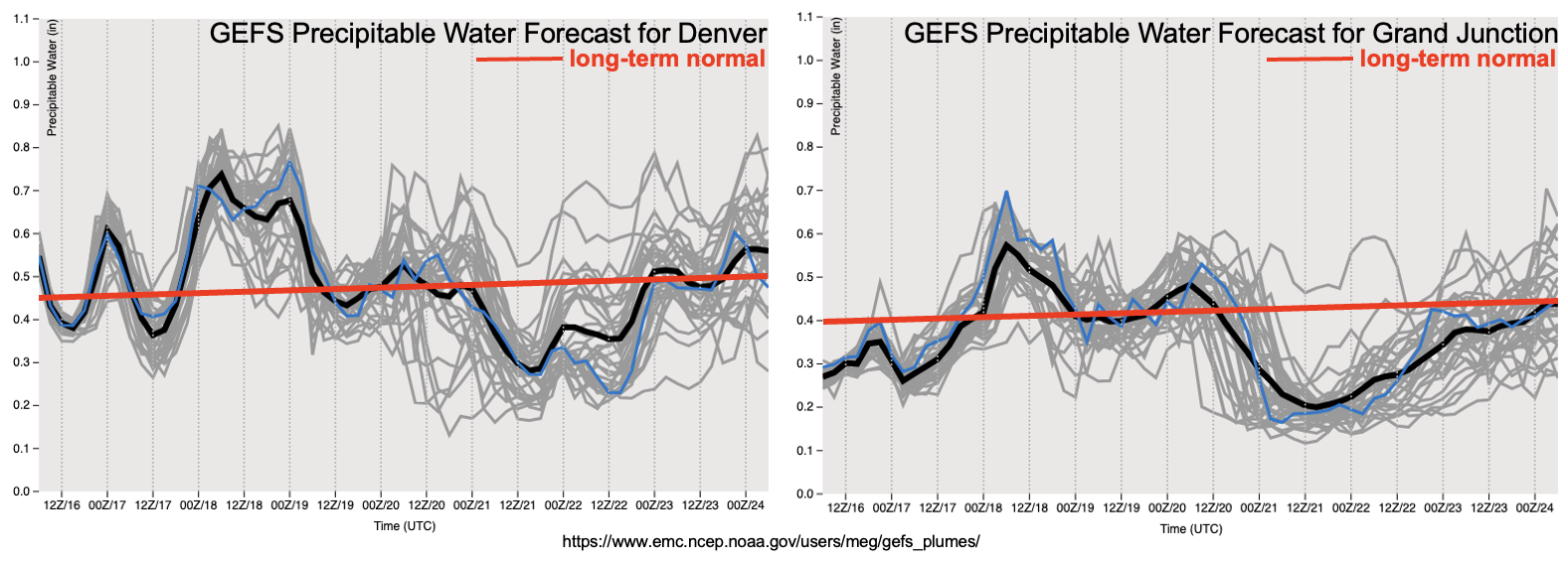
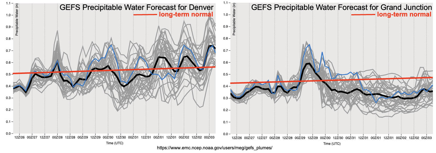
As shown below, the forecast PW from the GEFS shows generally above normal moisture content for Denver, while staying near or slightly below seasonal normal at Grand Junction. Regarding Event #1, there are two important factors that will generally limit the heavy rainfall threat. First, with the jet stream and/or jet streaks expected to reside over the Four Corners through next week, steering flow will continue its spring theme of being very fast (limiting convective rainfall at any given point). Second, although overall moisture content will be near seasonal normal, boundary layer moisture will be marginal. Thus, little in the way of flooding is expected, with widespread stratiform rain and snow events instead being the preferred precipitation mode.

Things do become more interesting by late next week when the atmospheric dynamics are expected to settle down, instead being replaced by a weak upper-level ridge. Residual moisture after a frontal passage is expected to pool over the southern Great Plains, with some of it extending back into southeastern Colorado. With much weaker flow overhead, and the appearance of instability, likely exceeding 1,000 J/kg, the risk of isolated heavy rainfall-producing storms appears high enough to warrant a Low-end Elevated flood threat (Event #2).

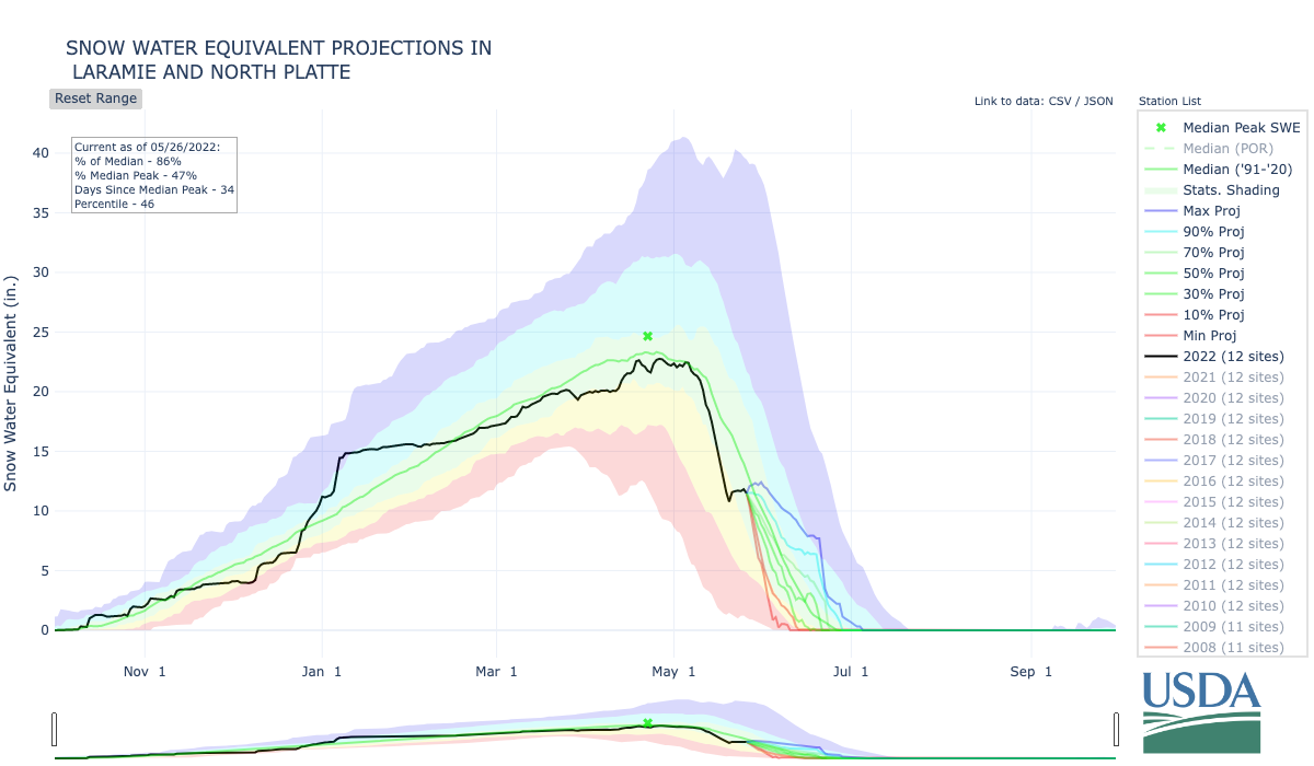
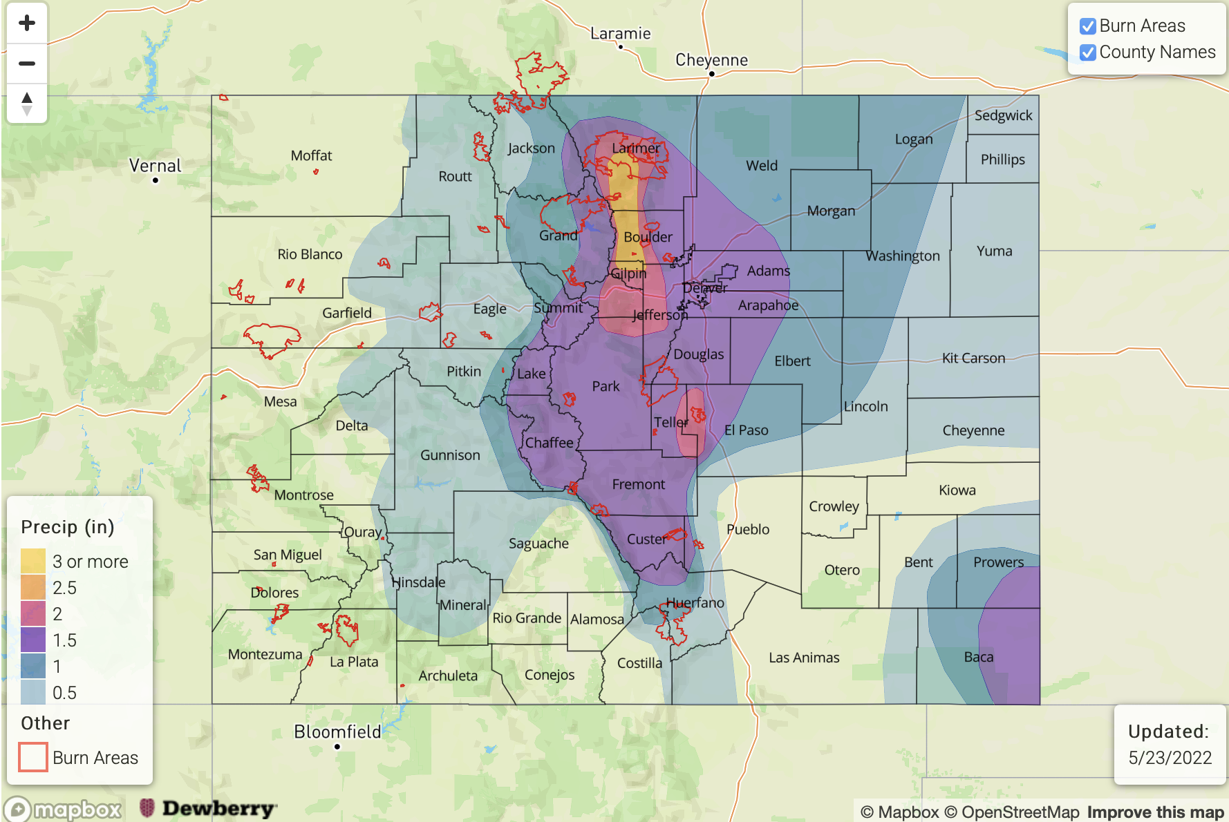
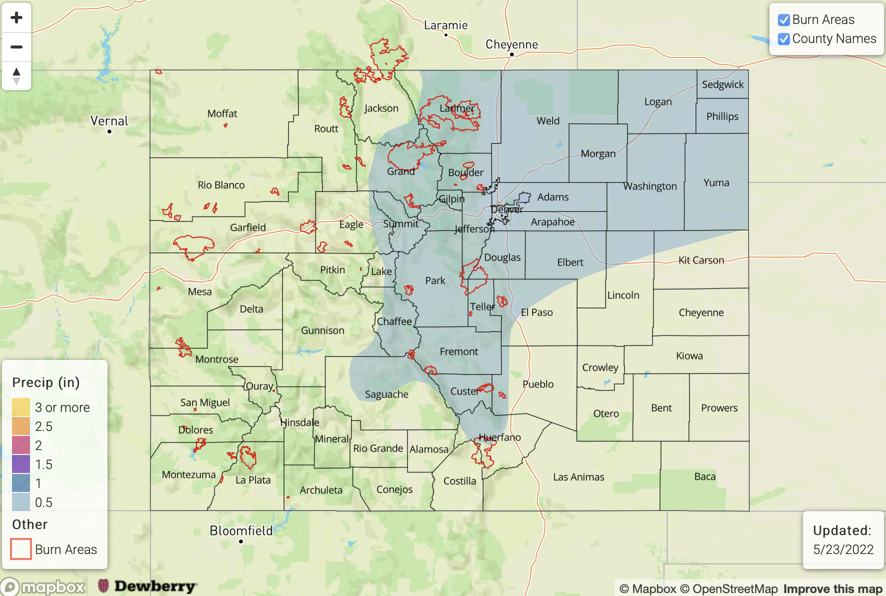
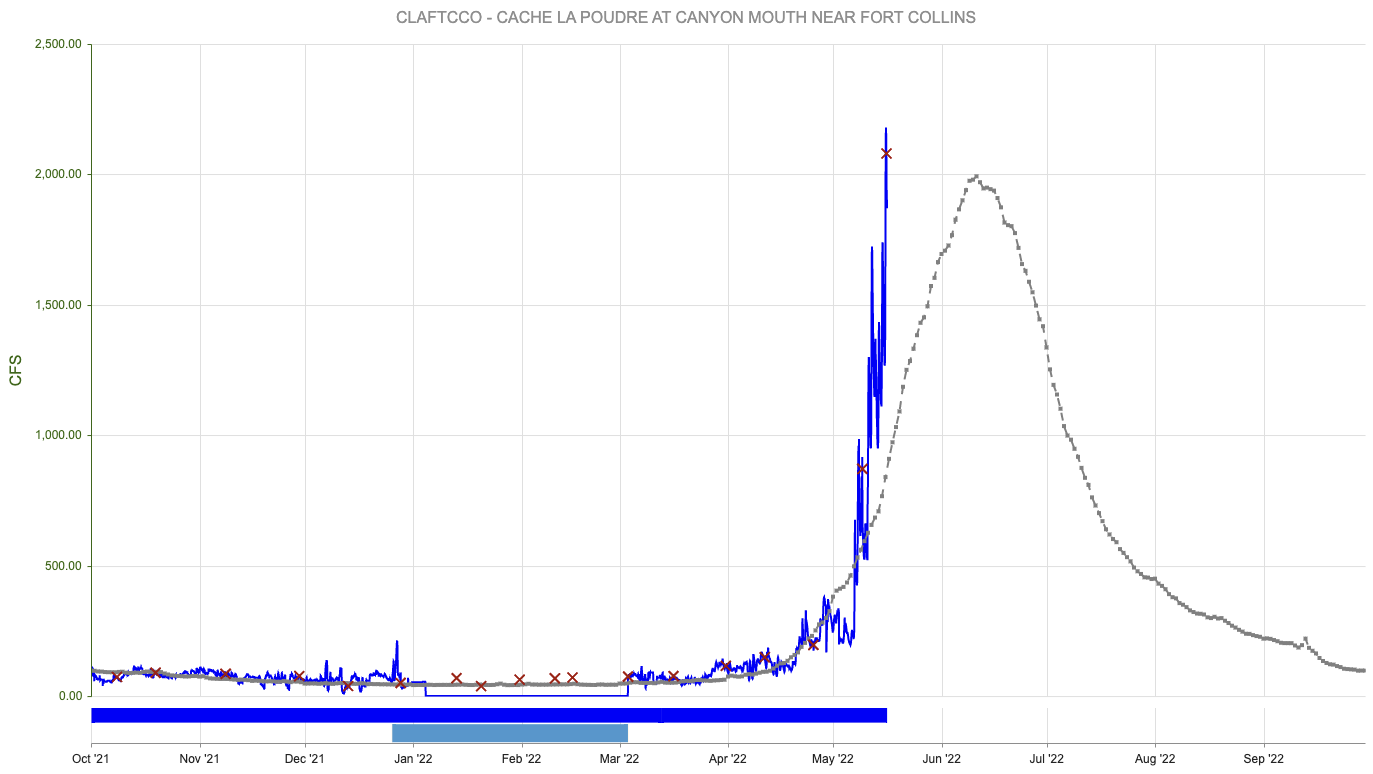
Before discussing the precipitation events in detail, let’s touch on the snowpack situation. With the recent cool conditions, the snowpack over central and northern Colorado continues to hold up. In fact, as shown above for the North Platte/Laramie basin SWE scenarios, with relatively minimal melting expected over the next 48 hours, an additional ~1.0 inch of SWE (as is expected during Event #1, see precipitation map below) will bring the average snowpack near or above seasonal normal for the first time since earlier in May. This is great news for the water supply situation, at least for parts of the Northern and Central Mountains.

The identified precipitation events are described in more detail below.

Event #1: Saturday – Wednesday (May 28 – June 1)

No Apparent Flood Threat As Widespread Rain And Snow Expected, Mainly North

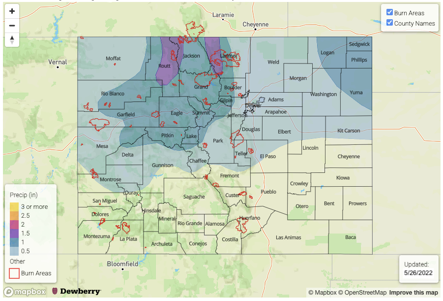
At least two separate periods of precipitation are expected within this timeframe. The first will occur over the 36-hour period beginning late Saturday through early Monday. At this time, it appears that a widespread 0.5 – 1.25 inches of rain and higher elevation snow will fall over the Northwest Slope, Northern Mountains, Front Range and northern portions of the Central Mountains. The snow level will drop down to 7,500 feet by Monday morning. A second batch of precipitation is looking more likely from Tuesday into Wednesday, this time favoring the eastern portions of the Northern Mountains and into the Front Range. Another 0.25-0.50 inches of rain and snow is expected with this event.

Further east over the plains, scattered rain showers are expected with both events with amounts perhaps totaling in the 0.5 – 0.75 inch range for localized areas. The Northeast Plains look to be favored. Convection appears to be minimal over this period, hence flooding is not expected at this time, although areas right along the KS border will be watched closely.

Event #2: Thursday – Friday (June 2 – June 3)

Low-end Elevated Flood Threat As Residual Moisture And Instability Combine For Southeast Colorado

The passage of a Pacific cool front will leave residual moisture over southeast Colorado, which combined with weak steering flow and expected sunshine should generate enough instability to produce isolated to widely scattered thunderstorms. The preferred region, at this time, appears to be the Southeast Mountains, Raton Ridge and Southeast Plains on Thursday. Then, by Friday, the focus will be mostly over the Southeast Plains. Isolated storms could produce 1.25 inches per hour of rainfall, which is enough to warrant a low-end flash flood threat.

FTO 05-23-2022: Drying Out With Hot Temperatures Returning By Thursday

Issue Date: Monday, May 23rd, 2022
Issue Time: 2:05PM MDT
Valid Dates: 5/24 – 6/7

The amplified pattern will stick around for the week and last into Memorial Day weekend, which means relatively active weather continues minus a pause in precipitation that begins mid-week. The slow-moving trough will sit over the state today, and tonight’s precipitation over the eastern plains and Southeast Mountains should continue into tomorrow. The Low eventually moves to the eastern border by early afternoon, and the wrap around precipitation should begin to diminish over the eastern plains by the evening hours. This will end Event #1 with some additional afternoon precipitation forecast tomorrow over the Front Range, Southeast Mountains, and western Palmer/Raton Ridge.

For today and tomorrow, PW remains below normal over western Colorado. A shortwave and a slight uptick in moisture is forecast to move through the area during the afternoon tomorrow, so isolated, light precipitation may be possible over the mountains near the Continental Divide. More widely scattered storms are forecast to develop over the Front Range and Southeast Mountains during the afternoon and evening hours. With steering flow becoming NNW behind the trough, accumulation should mostly stick to the mountains, but widely scattered storms may spill into the adjacent eastern plains.

Subsidence and drying moves in on Wednesday as the ridge axis shown above pushes eastward. Expect near normal temperatures to return for the majority of the state as the warmer air fills in from west to east. By Thursday, looking at above average temperatures for the forecast and much above average high temperatures for Friday as well. This is anticipated to begin the next round of widespread melting. More on that below.

There will likely be an uptick in moisture again for the holiday weekend, which is associated with the next incoming trough (Event #2). Low confident on the details, but it looks like the trough should drop another cold front through the state late Saturday or Sunday. Whether or not this trough lingers near the state or there’s a second shortwave that moves through the flow, there may need to be an extension to the Elevated threat on Thursday (next FTO).

High temperatures rebound into the 90Fs (lower elevations) and 70Fs (mountain valleys) by Thursday and Friday, which means the next round of snow melt will begin. There’s still quite a bit of snow over the northern mountains at the higher elevation sites. Paired with the widespread snow over over the lower elevation mountains from this last event, significant melting could cause local streams and creeks to run high. Less worried about the larger rivers at the moment, especially as they have receded quickly from the melting over the weekend, but we will be watching the gages along the South Platte, Arkansas and Cache La Poudre rivers. Over western Colorado, there is still some decent snowpack over the Grand Mesa and Elk Mountains, so local streams and creeks may be running high by this weekend over these regions. While large riverine flooding is not anticipated at this time, an Elevated threat has been issued for smaller streams and creeks across the higher elevations on Friday and Saturday.

Event #1: Tuesday (5/24)

No Apparent flood threat for stratiform rainfall (east) and rain/snow mix (west).

This is a quick 1-day event to round out Event #1 from last week’s FTO. Expect stratiform, wrap around precipitation to continue near the Low over the Southeast Plains, Southeast Mountains and Raton Ridge as it tracks east. This will fall as snow down to about ~9.5K feet, and the rainfall (east) is forecast to end by the evening hours. There should be some decent, localized accumulation throughout the day (up to 0.75 inches), but there is NO Apparent flood threat at this time. Additional scattered mountain rain/snow mix will be possible during the afternoon favoring areas near the Continental Divide for accumulation. The Front Range could receive isolated totals just under 1 inch. Rainfall may spill into the immediate adjacent plains with the best chance for this occurring over the Palmer Ridge and Southeast Plains. There is No Apparent threat issued with rainfall winding down statewide by late evening.

Event #2: Saturday – Tuesday (5/28 – 5/31)

Elevated/No Apparent flood threat for Memorial Day weekend when rainfall returns to the forecast.

Still a lot of uncertainty with this forecast, but it’s looking more likely that rainfall will return to the state over Memorial Day weekend. There’s enough moisture return both east and west with the next system, that scattered to numerous storms may be possible. It looks like a cold front will drop through the state sometime late on Saturday or Sunday. Could see some longer duration rainfall and heavier rainfall near the eastern border during this time, so there has been an Elevated threat issued for this reason. Cooler temperatures should stick around through Monday and Tuesday, possibly into Wednesday, along with the chance for scattered precipitation.

FTO 05-19-2022: Spring Storm to Bring Widespread Precipitation & Significant Snow to the Mountains

Issue Date: Thursday, May 19th, 2022
Issue Time: 2:40PM MDT
Valid Dates: 5/20 – 6/3

A very amplified atmospheric pattern and unusual spring weather is on tap for Event #1. Beginning tonight, a strong cold front will drop through the state as the trough axis marked below sinks south over the western US. Plenty of news outlets and the FTO have been covering this powerful system as it will bring significant snow to the high country along with some snow accumulation across the Urban Corridor and Palmer Ridge. Yep, you read that correctly. It’s hard to believe that the 80F and 90F temperatures today will plummet so quickly, but then again, it’s not too abnormal for Colorado to have 50F drops in temperature. Very strong dynamics with a jet overhead are forecast from Friday into late Saturday night, which will be the window for significant snowfall favoring the Front Range for the highest accumulation.

PW shows a nice uptick behind the front that will pass through tonight both east and west. That means that there will be plenty of moisture for meaningful accumulations, especially when comparing to the (lack) of rainfall as of late. There is also consensus with a drop in PW from Saturday evening into Sunday Morning. So, precipitation should begin taper off during this time, although there is still a good shot for more accumulation over the Southeast Mountains and Palmer Ridge Saturday afternoon into Saturday night. Temperatures should begin to warm up slightly on Sunday, although they will still be well-below average.

PW returns to near normal values to start the work week (east), which will keep widely scattered precipitation in the forecast until the ridge axis moves overhead on Wednesday. The lack of moisture return at Grand Junction (right) is related to this ridge axis sliding in from the west. So, expect the weather to dry out and warm up by mid-week with temperatures returning to above average values by Thursday.

Still watching the streamflow climb over the northern mountains. Elk River near Milner (Steamboat Springs area) reached into Action stage the last couple of days (shown below). Cache La Poudre above Fort Collins has also been running higher along with the Yampa River and Gore Creek near Minturn. None are expected to reach flood level, especially as the cold air moves in and shuts off the melting. When the above average temperatures return mid to late next week, snow melt will likely resume with some extra snowpack at the lower elevations contributing to runoff. There is No Apparent flood threat issued at this time as rivers and local streams should recover over the next few days, and thankfully there is little to no rain forecast over the mountains next week. We’ll still be keeping an eye on this next round of melting, so be sure to tune on Monday for the latest update.

Event #1: Friday Tuesday (5/20 5/24)

No Apparent flood threat as a late season spring snow event hits Colorado.

Hopefully you haven’t replaced your winter comforter with your summer quilt yet because it is going to get very cold Friday and Saturday night. Precipitation should begin with the passage of a cold front this evening over the northern mountains. The crossover to snow should happen very quickly, so not expecting much rainfall for the high elevations before the snow begins. Coverage of the precipitation is forecast to increase from Friday into the overnight hours across the Northern, Central and Front Range Mountains and the adjacent eastern plains. Temperatures nosedive statewide by Friday evening as a secondary push of cold air occurs. This is when the snow line should drop rapidly and snow should begin to accumulate in the adjacent plains. While some melting is anticipated, still looking at a few inches of snow for the Urban Corridor and 6-12” for the Palmer Ridge Saturday night as the temperatures drop. Over the northern mountains, for the duration of this event, widespread amounts of 2.5 inches of liquid equivalent are possible. Hazardous travel to say the least during this period. Be sure to unhook your hose and knock the snow off your trees and bushes to avoid broken branches.

Precipitation strength and coverage is expected to decrease Saturday into Sunday, but still expecting a rain/snow mix for the Southeast Mountains and adjacent plains on Saturday afternoon into the night. Monday and Tuesday, rainfall is forecast for the elevated ridges and adjacent eastern plains, but at this time there is No Apparent flood threat.

Event #2: SaturdayMonday (5/28 – 5/30)

No Apparent flood threat for Memorial Day weekend, but chance for rainfall returns.

Just wanted to mention that isolated to widely scattered storms could return to the forecast around Memorial Day weekend. Confidence is on the lower end for Event #2 this far out regarding timing, location and amount of rainfall. But it looks like the atmospheric pattern will stay active, which is always nice to see after such a dry spring. Temperatures should be near normal to slightly above average for the weekend, which will be welcome after this weekend’s cold snap.

FTO 05-16-2022: Very Warm With Storms Early, Then Major Pattern Change With Widespread Snow & Rain Event

Issue Date: Monday, May 16th, 2022
Issue Time: 2:30PM MDT
Valid Dates: 5/17 – 5/31

As discussed in today’s Flood Threat Bulletin, a bit more moisture and even precipitation, as meager as it may end up, is finally back in the forecast for parts of the state. As shown in the water vapor image, below, today will be a precursor to a fairly active week of weather for Colorado. Over the next two days, a modest disturbance that is currently entering the California coast will trek across out state. Within this disturbance (Event #1) will be multiple small shortwave features, amplified by our diurnal cycle (i.e. favoring high-elevation afternoon storms) that will provide scattered to locally numerous showers and storms over mainly the eastern half of the state.

As has been the story for many weeks now, and not entirely unexpected given that we are only in mid-May, moisture will be the primary limiting factor for the heavy rainfall threat. But, below, the forecast PW plumes from the GEFS ensembles do show a gradual increase in PW from today’s 0.4 – 0.7 inch range to 0.6 – 1.0 inches by Wednesday afternoon. Instability will also be modest, but sufficient enough to drive an isolated heavy rainfall threat mainly towards the NE/KS/OK borders. Isolated severe storms also appear likely, with the primary threats being damaging wind due to the dry sub-cloud layer, as well as large hail. By Thursday, drier, mainly westerly (downsloping) upper-level flow will drop PW and precipitation chances, instead the moisture possibly being replaced by a brief period of wildfire threat.

By Friday, things get really interesting as an entire large trough currently over the Gulf of Alaska will make Colorado its target (Event #2). This will lead to a 36-48 period of strong dynamics, sufficient moisture and cold enough air to blanket most of the higher terrain with a significant late-season snow, along with lower elevation rain. In fact, at least a short-term period of snowfall will be possible for the lower elevations, below 6,000 feet. We do not anticipate any major flooding issues with this event, although streamflow will certainly rise due to the combination of rain early in the event, as well as the ensuing snowmelt beginning on Sunday.

Speaking of snowmelt, the warm temperatures over the next 72 hours will push melt rates higher over the Northern Mountains. A glance over all gauged mountain streams reveals two possible trouble spots (see below). First, snowmelt is in full swing for the Elk River basin north of Steamboat Springs. The Elk River flow could reach the “Action” level (roughly 4,800 cfs) during the overnight hours Tuesday – Thursday this week (keep in mind snowmelt-induced flow in lower elevations typically peaks during the late evening/overnight hours due to the lag in meltwater response). Second, for the Cache La Poudre, snowmelt is about halfway complete but will increase through Thursday. This river may also reach “Action” level (roughly 3,500 cfs) mainly upstream of Fort Collins. In both situations, however, there is no major flooding expected.

The identified precipitation events are described in more detail below.

Event #1: Tuesday – Wednesday (May 17 – May 18)

Scattered PM Storms Mainly Over Eastern Plains; Low-end Elevated Flood Threat

Scattered showers and thunderstorms are expected over mainly central and eastern Colorado on the Tuesday and Wednesday afternoons. Max 1-hour rainfall up to 0.7 inches may occur for higher elevations above 5,500 feet. For the lower elevations of the Northeast Plains and Southeast Plains, max 1-hour rainfall up to 1.6 inches looks possible on Tuesday and up to 1.9 inches on Wednesday as PW approaches 1.0 inch. An Elevated flood threat is posted for this event, due to the risk of short-term flash flooding. Coverage of storms will be highest over the Northeast Plains on Tuesday and then the Palmer Divide and Southeast Plains on Wednesday. Isolated severe storms will be possible both days with strong straight-line winds being the primary threat. However, hail up to 1.5 is also possible over far eastern areas.

Event #2: Friday – Saturday (May 20 – May 21)

Widespread Snow and Rain Event; No Apparent Flood Threat

Widespread rain and snow is expected beginning Friday morning over northwest Colorado and transitioning south and east through the day. Total event precipitation of up to 2.0 inches looks attainable over parts of the Front Range and perhaps Southeast Mountains where local meteorological dynamics are maximized. However, widespread precipitation amounts exceeding 0.5 inches are expected for most of central Colorado. Over the Northern Mountains, we are watching the interplay of how higher pre-event streamflow due to snowmelt coincides with the new runoff expected from this storm. At this time, however, there is No Apparent Flood Threat.

Event #3: Wednesday – Thursday (May 25 – May 26)

Isolated Storms Return To Forecast, But No Apparent Flood Threat At This Time

A Pacific cool front is expected to reach Colorado sometime by the middle of next week, leading to an increase in moisture. At this time, the orientation of steering flow in a mainly westerly fashion leads to skepticism as to how much moisture return will be possible this early in the season. However, isolated thunderstorms are likely to enter the forecast by the middle of next week, with the highest coverage expected along the NE/KS/OK borders. At this time, there is No Apparent Flood Threat and precipitation amounts less than 0.5 inches are expected.