Issue Date: Thursday, May 19th, 2022
Issue Time: 2:40PM MDT
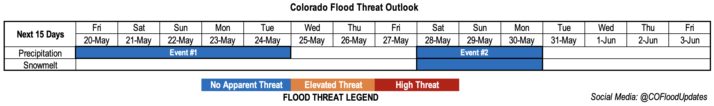
Valid Dates: 5/20 – 6/3
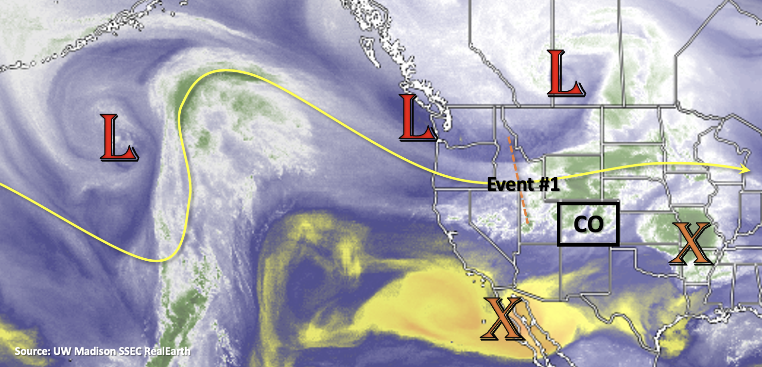
A very amplified atmospheric pattern and unusual spring weather is on tap for Event #1. Beginning tonight, a strong cold front will drop through the state as the trough axis marked below sinks south over the western US. Plenty of news outlets and the FTO have been covering this powerful system as it will bring significant snow to the high country along with some snow accumulation across the Urban Corridor and Palmer Ridge. Yep, you read that correctly. It’s hard to believe that the 80F and 90F temperatures today will plummet so quickly, but then again, it’s not too abnormal for Colorado to have 50F drops in temperature. Very strong dynamics with a jet overhead are forecast from Friday into late Saturday night, which will be the window for significant snowfall favoring the Front Range for the highest accumulation.
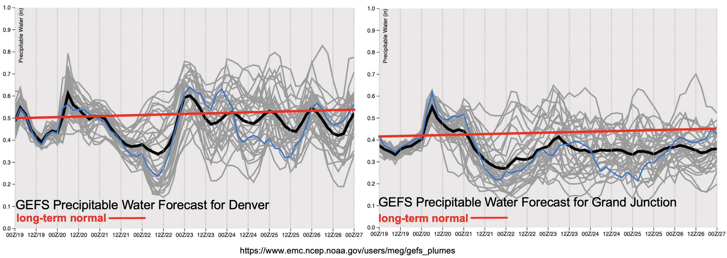
PW shows a nice uptick behind the front that will pass through tonight both east and west. That means that there will be plenty of moisture for meaningful accumulations, especially when comparing to the (lack) of rainfall as of late. There is also consensus with a drop in PW from Saturday evening into Sunday Morning. So, precipitation should begin taper off during this time, although there is still a good shot for more accumulation over the Southeast Mountains and Palmer Ridge Saturday afternoon into Saturday night. Temperatures should begin to warm up slightly on Sunday, although they will still be well-below average.
PW returns to near normal values to start the work week (east), which will keep widely scattered precipitation in the forecast until the ridge axis moves overhead on Wednesday. The lack of moisture return at Grand Junction (right) is related to this ridge axis sliding in from the west. So, expect the weather to dry out and warm up by mid-week with temperatures returning to above average values by Thursday.
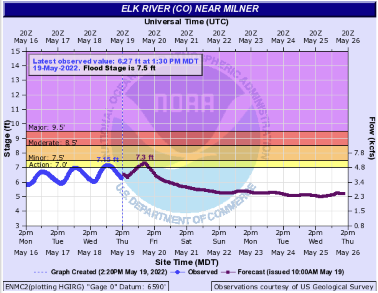
Still watching the streamflow climb over the northern mountains. Elk River near Milner (Steamboat Springs area) reached into Action stage the last couple of days (shown below). Cache La Poudre above Fort Collins has also been running higher along with the Yampa River and Gore Creek near Minturn. None are expected to reach flood level, especially as the cold air moves in and shuts off the melting. When the above average temperatures return mid to late next week, snow melt will likely resume with some extra snowpack at the lower elevations contributing to runoff. There is No Apparent flood threat issued at this time as rivers and local streams should recover over the next few days, and thankfully there is little to no rain forecast over the mountains next week. We’ll still be keeping an eye on this next round of melting, so be sure to tune on Monday for the latest update.
Event #1: Friday – Tuesday (5/20 – 5/24)
No Apparent flood threat as a late season spring snow event hits Colorado.
Hopefully you haven’t replaced your winter comforter with your summer quilt yet because it is going to get very cold Friday and Saturday night. Precipitation should begin with the passage of a cold front this evening over the northern mountains. The crossover to snow should happen very quickly, so not expecting much rainfall for the high elevations before the snow begins. Coverage of the precipitation is forecast to increase from Friday into the overnight hours across the Northern, Central and Front Range Mountains and the adjacent eastern plains. Temperatures nosedive statewide by Friday evening as a secondary push of cold air occurs. This is when the snow line should drop rapidly and snow should begin to accumulate in the adjacent plains. While some melting is anticipated, still looking at a few inches of snow for the Urban Corridor and 6-12” for the Palmer Ridge Saturday night as the temperatures drop. Over the northern mountains, for the duration of this event, widespread amounts of 2.5 inches of liquid equivalent are possible. Hazardous travel to say the least during this period. Be sure to unhook your hose and knock the snow off your trees and bushes to avoid broken branches.
Precipitation strength and coverage is expected to decrease Saturday into Sunday, but still expecting a rain/snow mix for the Southeast Mountains and adjacent plains on Saturday afternoon into the night. Monday and Tuesday, rainfall is forecast for the elevated ridges and adjacent eastern plains, but at this time there is No Apparent flood threat.
Event #2: Saturday – Monday (5/28 – 5/30)
No Apparent flood threat for Memorial Day weekend, but chance for rainfall returns.
Just wanted to mention that isolated to widely scattered storms could return to the forecast around Memorial Day weekend. Confidence is on the lower end for Event #2 this far out regarding timing, location and amount of rainfall. But it looks like the atmospheric pattern will stay active, which is always nice to see after such a dry spring. Temperatures should be near normal to slightly above average for the weekend, which will be welcome after this weekend’s cold snap.