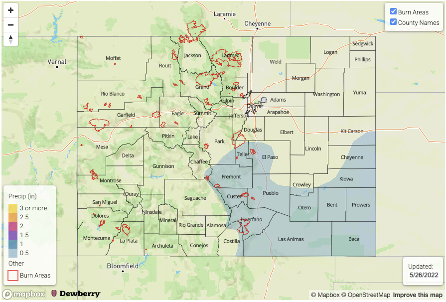
Issue Date: Thursday, May 26th, 2022
Issue Time: 3PM MDT
Valid Dates: 5/27-6/10
NOTE: Unless conditions warrant, the next Flood Threat Outlook will be released on Tuesday, May 31st. Flood Threat Bulletins will continue to be issued daily over the Memorial Day weekend.
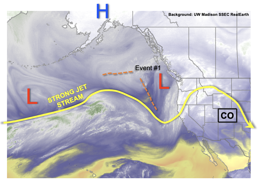
For central and northern Colorado, it seems that Mother Nature heard all of our griping about the dusty, dry and windy April. Over the next week or so, as shown in the water vapor image, below, a strong jet stream will continue to favor troughs and/or cut-off disturbances over Colorado. With the availability of moisture continuing its seasonal ascent, this will continue to favor scattered to widespread precipitation beginning late Saturday and into the middle of next week (Event #1). After a brief 48-hour warm-up, the other major story will be the continued below normal temperatures that will persist statewide, but especially over the central and western areas. Overall, all but southwest Colorado is expected to see beneficial precipitation from Event #1. The good news for the Southwest Slope is that cooler conditions should somewhat temper the fire threat.
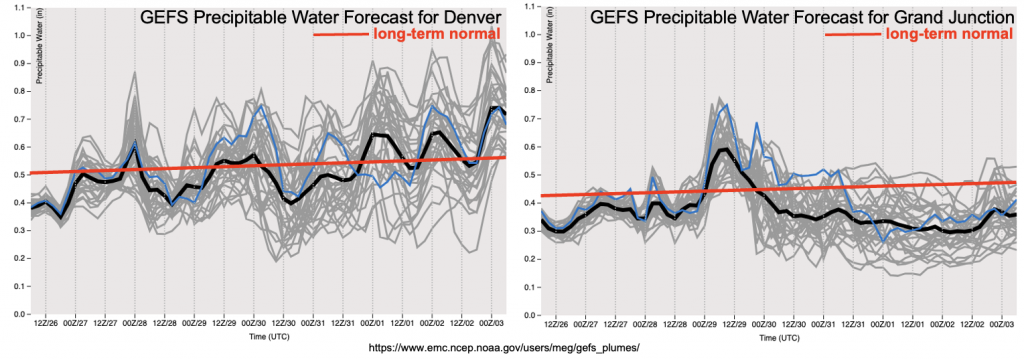
As shown below, the forecast PW from the GEFS shows generally above normal moisture content for Denver, while staying near or slightly below seasonal normal at Grand Junction. Regarding Event #1, there are two important factors that will generally limit the heavy rainfall threat. First, with the jet stream and/or jet streaks expected to reside over the Four Corners through next week, steering flow will continue its spring theme of being very fast (limiting convective rainfall at any given point). Second, although overall moisture content will be near seasonal normal, boundary layer moisture will be marginal. Thus, little in the way of flooding is expected, with widespread stratiform rain and snow events instead being the preferred precipitation mode.
Things do become more interesting by late next week when the atmospheric dynamics are expected to settle down, instead being replaced by a weak upper-level ridge. Residual moisture after a frontal passage is expected to pool over the southern Great Plains, with some of it extending back into southeastern Colorado. With much weaker flow overhead, and the appearance of instability, likely exceeding 1,000 J/kg, the risk of isolated heavy rainfall-producing storms appears high enough to warrant a Low-end Elevated flood threat (Event #2).
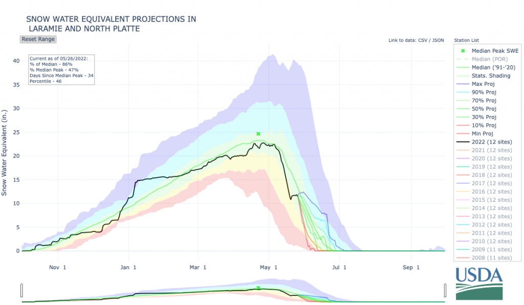
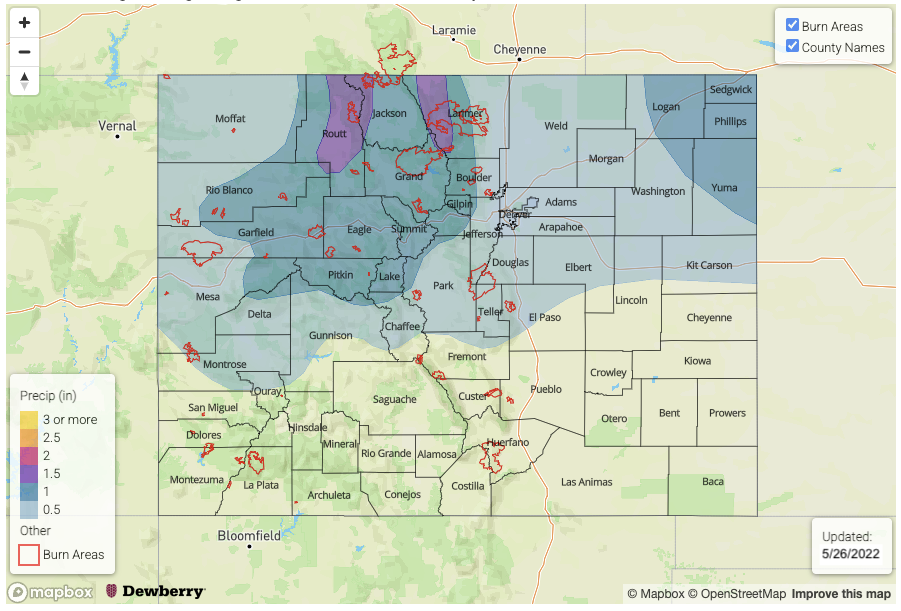
Before discussing the precipitation events in detail, let’s touch on the snowpack situation. With the recent cool conditions, the snowpack over central and northern Colorado continues to hold up. In fact, as shown above for the North Platte/Laramie basin SWE scenarios, with relatively minimal melting expected over the next 48 hours, an additional ~1.0 inch of SWE (as is expected during Event #1, see precipitation map below) will bring the average snowpack near or above seasonal normal for the first time since earlier in May. This is great news for the water supply situation, at least for parts of the Northern and Central Mountains.
The identified precipitation events are described in more detail below.
Event #1: Saturday – Wednesday (May 28 – June 1)
No Apparent Flood Threat As Widespread Rain And Snow Expected, Mainly North
At least two separate periods of precipitation are expected within this timeframe. The first will occur over the 36-hour period beginning late Saturday through early Monday. At this time, it appears that a widespread 0.5 – 1.25 inches of rain and higher elevation snow will fall over the Northwest Slope, Northern Mountains, Front Range and northern portions of the Central Mountains. The snow level will drop down to 7,500 feet by Monday morning. A second batch of precipitation is looking more likely from Tuesday into Wednesday, this time favoring the eastern portions of the Northern Mountains and into the Front Range. Another 0.25-0.50 inches of rain and snow is expected with this event.
Further east over the plains, scattered rain showers are expected with both events with amounts perhaps totaling in the 0.5 – 0.75 inch range for localized areas. The Northeast Plains look to be favored. Convection appears to be minimal over this period, hence flooding is not expected at this time, although areas right along the KS border will be watched closely.
Event #2: Thursday – Friday (June 2 – June 3)
Low-end Elevated Flood Threat As Residual Moisture And Instability Combine For Southeast Colorado
The passage of a Pacific cool front will leave residual moisture over southeast Colorado, which combined with weak steering flow and expected sunshine should generate enough instability to produce isolated to widely scattered thunderstorms. The preferred region, at this time, appears to be the Southeast Mountains, Raton Ridge and Southeast Plains on Thursday. Then, by Friday, the focus will be mostly over the Southeast Plains. Isolated storms could produce 1.25 inches per hour of rainfall, which is enough to warrant a low-end flash flood threat.

