Issue Date: Monday, May 16th, 2022
Issue Time: 2:30PM MDT
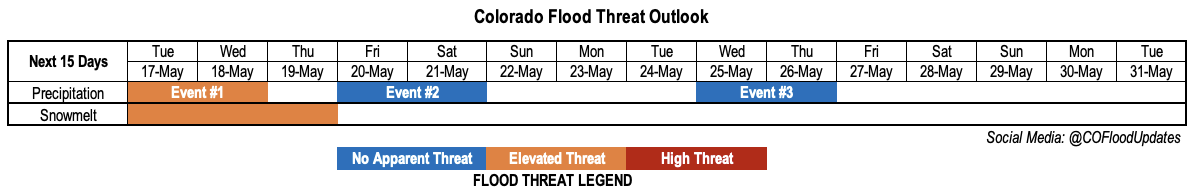
Valid Dates: 5/17 – 5/31
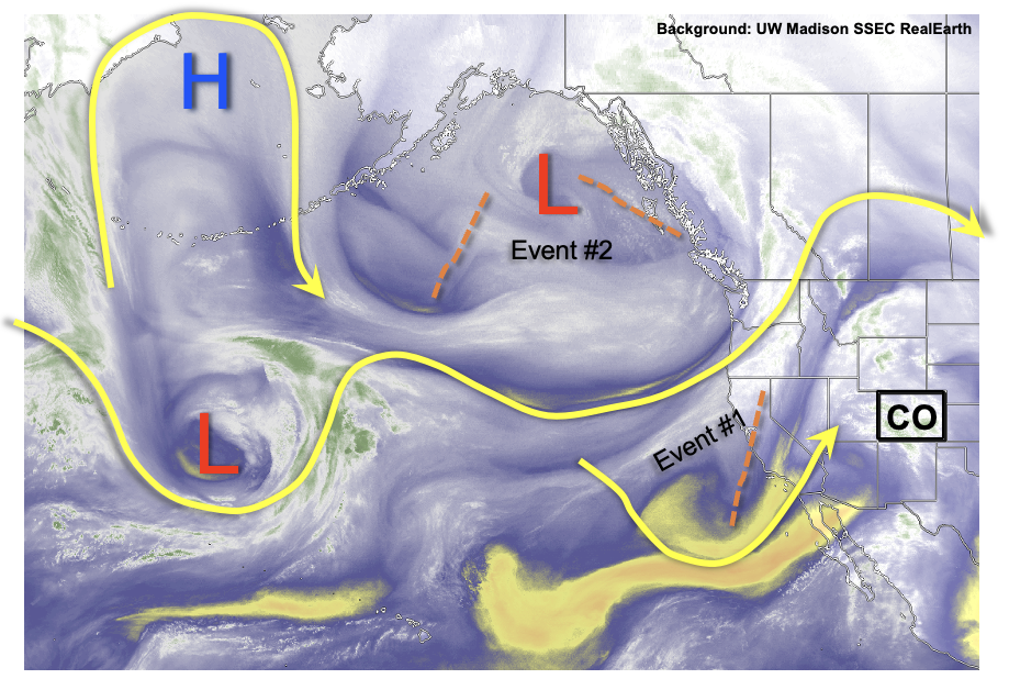
As discussed in today’s Flood Threat Bulletin, a bit more moisture and even precipitation, as meager as it may end up, is finally back in the forecast for parts of the state. As shown in the water vapor image, below, today will be a precursor to a fairly active week of weather for Colorado. Over the next two days, a modest disturbance that is currently entering the California coast will trek across out state. Within this disturbance (Event #1) will be multiple small shortwave features, amplified by our diurnal cycle (i.e. favoring high-elevation afternoon storms) that will provide scattered to locally numerous showers and storms over mainly the eastern half of the state.
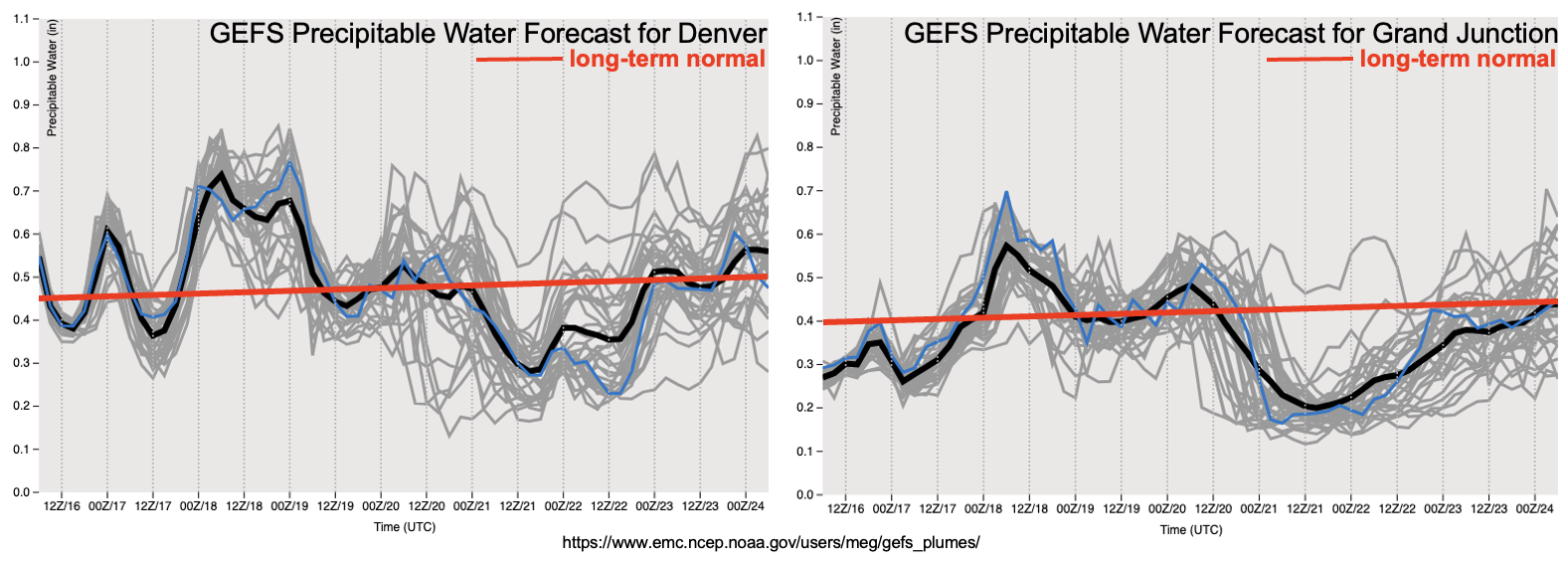
As has been the story for many weeks now, and not entirely unexpected given that we are only in mid-May, moisture will be the primary limiting factor for the heavy rainfall threat. But, below, the forecast PW plumes from the GEFS ensembles do show a gradual increase in PW from today’s 0.4 – 0.7 inch range to 0.6 – 1.0 inches by Wednesday afternoon. Instability will also be modest, but sufficient enough to drive an isolated heavy rainfall threat mainly towards the NE/KS/OK borders. Isolated severe storms also appear likely, with the primary threats being damaging wind due to the dry sub-cloud layer, as well as large hail. By Thursday, drier, mainly westerly (downsloping) upper-level flow will drop PW and precipitation chances, instead the moisture possibly being replaced by a brief period of wildfire threat.
By Friday, things get really interesting as an entire large trough currently over the Gulf of Alaska will make Colorado its target (Event #2). This will lead to a 36-48 period of strong dynamics, sufficient moisture and cold enough air to blanket most of the higher terrain with a significant late-season snow, along with lower elevation rain. In fact, at least a short-term period of snowfall will be possible for the lower elevations, below 6,000 feet. We do not anticipate any major flooding issues with this event, although streamflow will certainly rise due to the combination of rain early in the event, as well as the ensuing snowmelt beginning on Sunday.
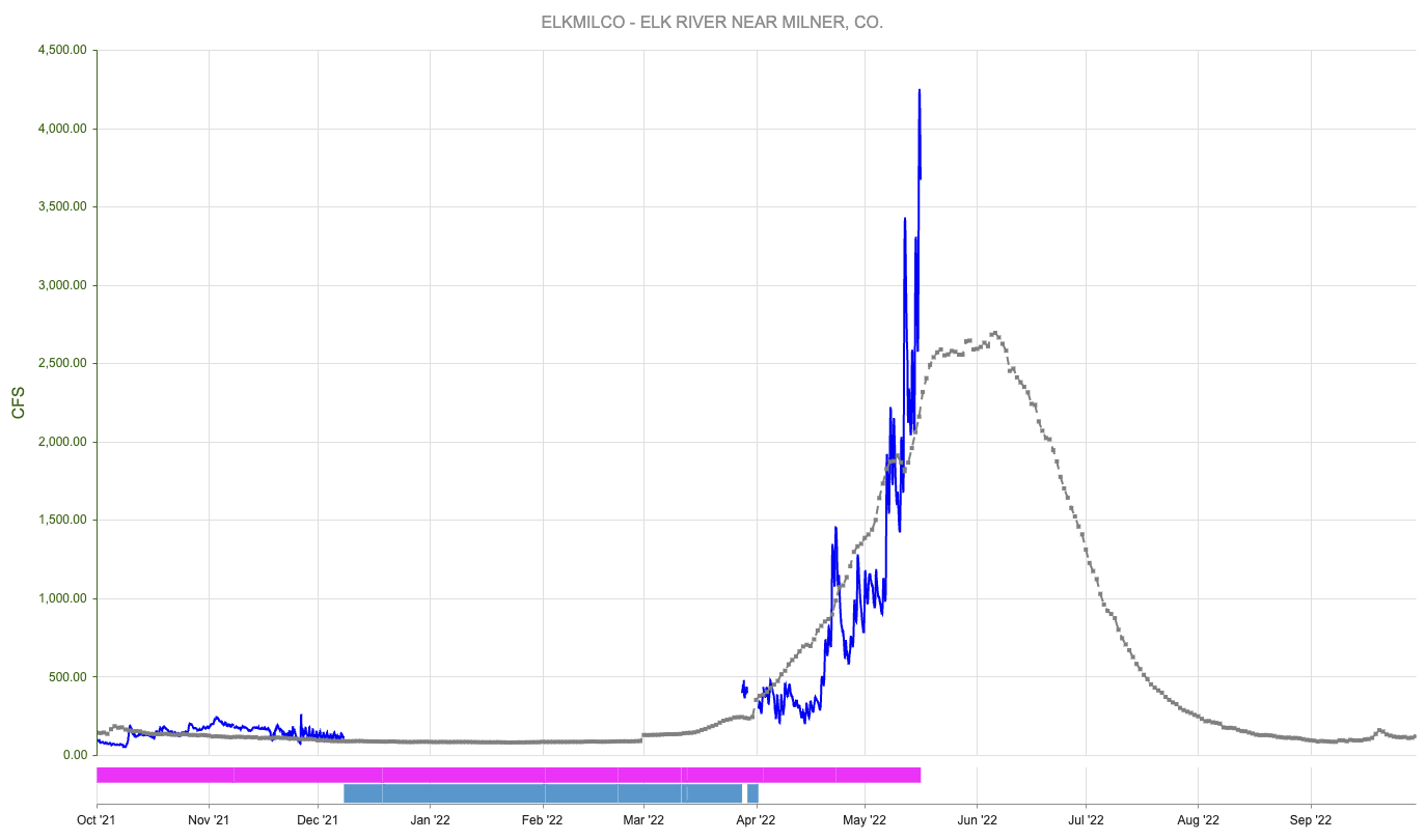
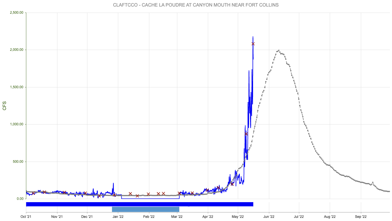
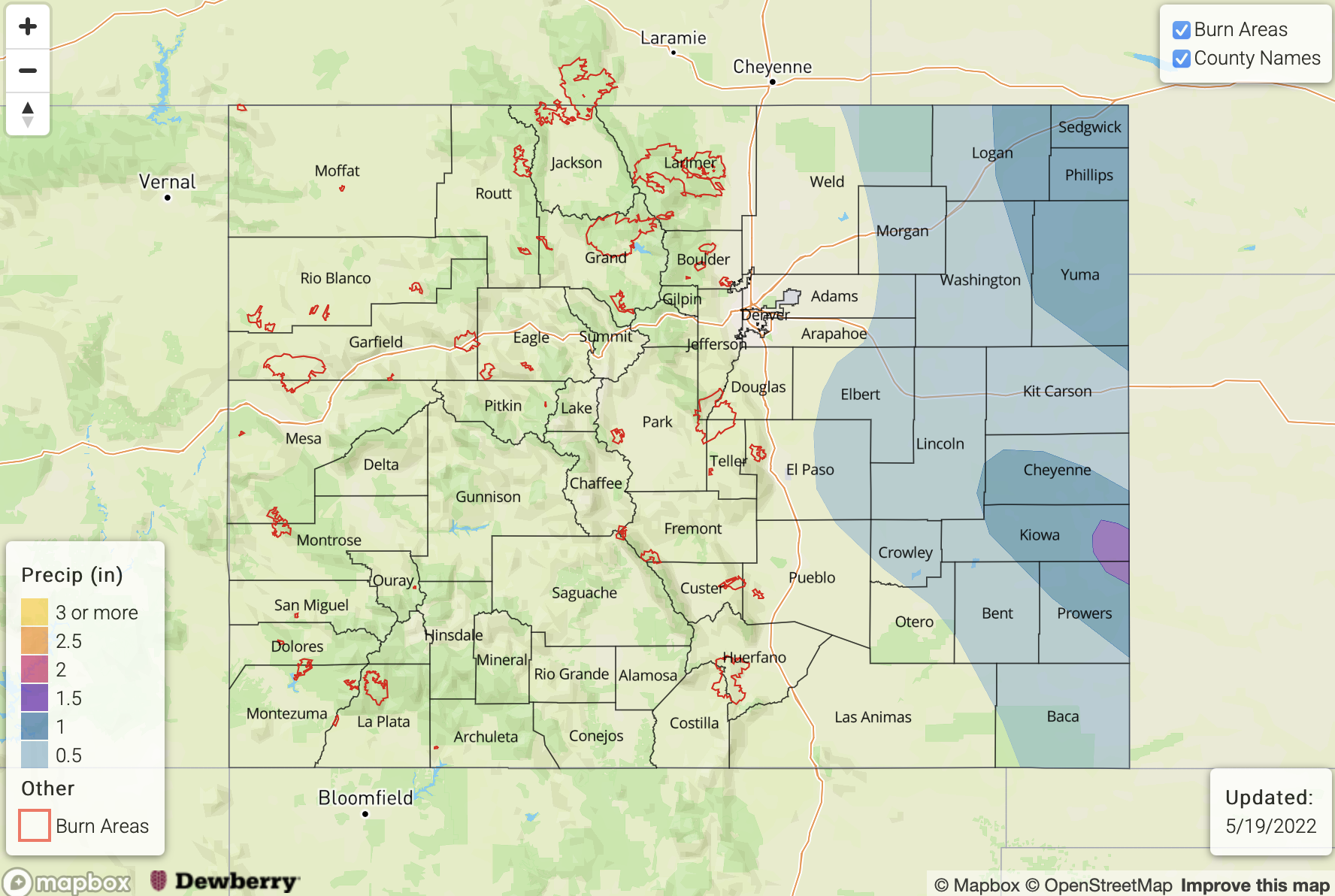
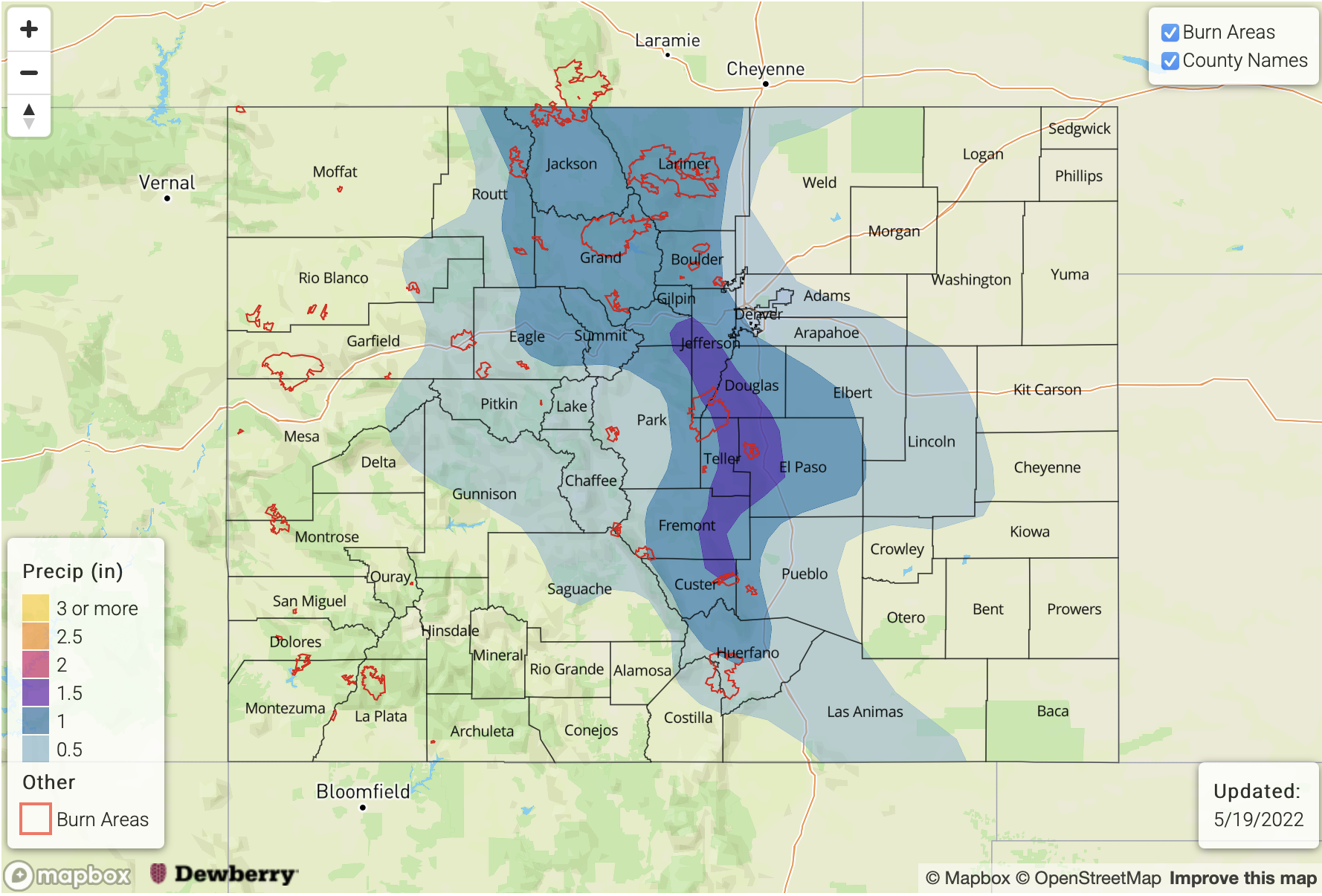
Speaking of snowmelt, the warm temperatures over the next 72 hours will push melt rates higher over the Northern Mountains. A glance over all gauged mountain streams reveals two possible trouble spots (see below). First, snowmelt is in full swing for the Elk River basin north of Steamboat Springs. The Elk River flow could reach the “Action” level (roughly 4,800 cfs) during the overnight hours Tuesday – Thursday this week (keep in mind snowmelt-induced flow in lower elevations typically peaks during the late evening/overnight hours due to the lag in meltwater response). Second, for the Cache La Poudre, snowmelt is about halfway complete but will increase through Thursday. This river may also reach “Action” level (roughly 3,500 cfs) mainly upstream of Fort Collins. In both situations, however, there is no major flooding expected.
The identified precipitation events are described in more detail below.
Event #1: Tuesday – Wednesday (May 17 – May 18)
Scattered PM Storms Mainly Over Eastern Plains; Low-end Elevated Flood Threat
Scattered showers and thunderstorms are expected over mainly central and eastern Colorado on the Tuesday and Wednesday afternoons. Max 1-hour rainfall up to 0.7 inches may occur for higher elevations above 5,500 feet. For the lower elevations of the Northeast Plains and Southeast Plains, max 1-hour rainfall up to 1.6 inches looks possible on Tuesday and up to 1.9 inches on Wednesday as PW approaches 1.0 inch. An Elevated flood threat is posted for this event, due to the risk of short-term flash flooding. Coverage of storms will be highest over the Northeast Plains on Tuesday and then the Palmer Divide and Southeast Plains on Wednesday. Isolated severe storms will be possible both days with strong straight-line winds being the primary threat. However, hail up to 1.5 is also possible over far eastern areas.
Event #2: Friday – Saturday (May 20 – May 21)
Widespread Snow and Rain Event; No Apparent Flood Threat
Widespread rain and snow is expected beginning Friday morning over northwest Colorado and transitioning south and east through the day. Total event precipitation of up to 2.0 inches looks attainable over parts of the Front Range and perhaps Southeast Mountains where local meteorological dynamics are maximized. However, widespread precipitation amounts exceeding 0.5 inches are expected for most of central Colorado. Over the Northern Mountains, we are watching the interplay of how higher pre-event streamflow due to snowmelt coincides with the new runoff expected from this storm. At this time, however, there is No Apparent Flood Threat.
Event #3: Wednesday – Thursday (May 25 – May 26)
Isolated Storms Return To Forecast, But No Apparent Flood Threat At This Time
A Pacific cool front is expected to reach Colorado sometime by the middle of next week, leading to an increase in moisture. At this time, the orientation of steering flow in a mainly westerly fashion leads to skepticism as to how much moisture return will be possible this early in the season. However, isolated thunderstorms are likely to enter the forecast by the middle of next week, with the highest coverage expected along the NE/KS/OK borders. At this time, there is No Apparent Flood Threat and precipitation amounts less than 0.5 inches are expected.