FTB 07-08-2020: Hot & Dry

Issue Date: Wednesday, July 8th, 2020
Issue Time: 8:20AM MDT

— Flooding is NOT expected today

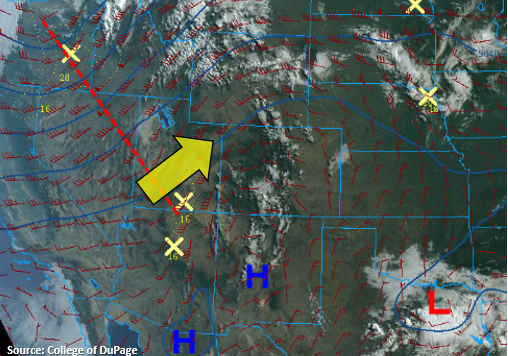
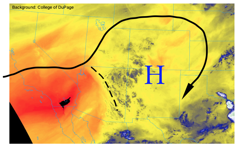
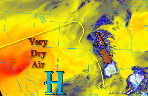
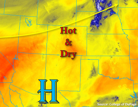
Weak southwesterly flow is present over the state as the trough from yesterday continues its eastward migration (north of Colorado). At the same time, the High (to our south) will begin to reestablish itself, so flow aloft is anticipated to become more zonal by this afternoon. This westerly wind will pull in an even drier, hot air mass, which can be seen by the dark orange/red over Utah, and downsloping winds will mix out any remaining moisture over eastern Colorado. All in all, it will be too dry for rain across the majority of the state, so expect only broken, mid-level cloud cover for the mountains and adjacent eastern plains this afternoon and evening. There is an outside chance (30-40%) for some weak rainfall over the northern border as storms fire off the Cheyenne Ridge. However, surface moisture will be limited, so rain totals are expected to remain under 0.25 inches.

Lastly, elevated fire danger is anticipated again. A Red Flag Warning has been issued for all of western Colorado and the high country today as relative humidity drops into the single digits and southwesterly/westerly surface winds increase to 10 – 20 mph. Please use extreme caution with any activity that can produce a spark.

Today’s Flood Threat Map

For more information on today’s flood threat, see the map below. If there is a threat, hover over the threat areas for more details, and click on burn areas to learn more about them. For Zone-Specific forecasts, scroll below the threat map.

Zone-Specific Forecasts:

Southeast Plains, Northeast Plains, Palmer Ridge, Raton Ridge, & Urban Corridor:

It’ll be too dry for much rainfall today except along the northern border where a weak storm may wander off the Cheyenne Ridge. Max 1-hour rain rates up to 0.25 inches will still be possible, but with the dry surface layer, rain totals are anticipated to closer to 0.15 inches. Brief gusty winds will also be possible as the storms dissipate. Other than that, only a slight increase in mid-level cloud cover is forecast over the Palmer Ridge and I-25 corridor. Highs will be similar to yesterday, but may be a degree or two warmer. Flooding is not forecast.

Primetime: 3PM to 8PM

San Juan Mountains, Central Mountains, Northern Mountains, Southeast Mountains, Front Range, Northwest Slope, San Luis Valley, Grand Valley, & Southwest Slope:

A Red Flag Warning has been issued for these regions from noon today to 9PM tonight. Southwest/westerly surface winds in the 10 to 20 mph are anticipated (gusts up to 35 mph) with relativity humidity values dropping to below 10%. This will cause another day of elevated fire danger for the state. Highs will be similar to yesterday with a slight uptick of a degree or two possible, so it’s going to be hot! Rainfall is not forecast.

FTB 07-07-2020: High Fire Danger Over Western CO & the Mountains with Weak Convection Forecast for the Eastern Plains

Issue Date: Tuesday, July 7th, 2020
Issue Time: 8:55AM MDT

— Flooding is NOT expected today

The trough to the northwest will start to move eastward today (red dashed line) causing flow aloft to become more southwesterly west of the Continental Divide (yellow arrow) and more westerly over eastern Colorado. This will entrain a very dry, hot air mass, which will mix out the mid-level moisture causing the morning cloud cover over the mountains. With large dew point depressions this afternoon (limited surface moisture), only weak, scattered storms are anticipated to form over the eastern mountains. Some extra mid-level energy from the trough will likely help kick off this high-based convection and allow the convection to survive as it moves off the mountains. If storms can stay intact, they should somewhat intensify as they make their way into the eastern plains and across the Raton Ridge where slightly better moisture will reside. Flooding is not expected from storms today, and gusty outflow winds will be the main threat due to the dry boundary layer. Over the far eastern plains and southern Raton Ridge, a couple stronger storms may produce some small hail, but severe storm chances are low.

Back to the west, relative humidity values are expected to drop fast with the hot, dry air moving overhead. Additionally, the passing trough will increase southwest surface to 10-20 mph (gusts up to 35 mph), so a Red Flag Warning has been issued for all of western Colorado and the mountains. A Red Flag Warning has also been issued for portions of the Northeast Plains and eastern Palmer Ridge with westerly surface winds anticipated to reach the 15 to 20 mph range and relative humidity dropping into the single digits. Please tune into your local NWS office for the latest on fire danger over your area.

Today’s Flood Threat Map

For more information on today’s flood threat, see the map below. If there is a threat, hover over the threat areas for more details, and click on burn areas to learn more about them. For Zone-Specific forecasts, scroll below the threat map.

Zone-Specific Forecasts:

Southeast Mountains, Front Range, Southeast Plains, Northeast Plains, Palmer Ridge, Raton Ridge, & Urban Corridor:

Expect high temperatures to be on the rise this afternoon with upper 90Fs forecast for the Urban Corridor and 100F over the eastern plains. High-based convection will kick off over the eastern mountains with the help of some mid-level energy. Expecting storms to produce more wind/cloud cover today than wetting rainfall; especially back west. The storms that can survive the dry environment, and make it into the eastern plains, will be capable of producing small hail and max 1-hour rain rates up to 0.75 inches. The best chance for storm survival looks to be along the southern Raton Ridge. Total rainfall up to 0.90 inches will be possible. Storm activity should end a couple hours after sundown as instability drops off.

Primetime: 1PM to 10PM

San Juan Mountains, Central Mountains, Northern Mountains, Northwest Slope, San Luis Valley, Grand Valley, & Southwest Slope:

It’s going to be dry and hot with Elevated fire danger this afternoon. A Red Flag Warning has been issued for all of these zones. High temperatures over the Grand Valley will flirt with the century mark, and highs over the mountain will reach the upper-70Fs to low 80Fs. Only broken cloud cover is forecast this afternoon near the Continental Divide, so be sure to keep yourself hydrated if you’re outside.

FTB 07-06-2020: Scattered High-Based Storms to Start a Very Hot Week

Issue Date: Monday, July 6th, 2020
Issue Time: 8:30AM MDT

—Flooding is NOT expected today

This morning’s water vapor image, below, shows that an upper-level ridge continues to hold its place over Colorado. However, it is not in top shape, as there is some monsoon-origin mid and upper-level moisture anchored to a weak mid-level disturbance making its way northeastward towards the Four Corners. This disturbance will provide mainly (welcome!) cloud cover and little rainfall this afternoon as the boundary layer has dried out over the past 24-48 hours. This morning’s PW at Grand Junction and Denver was 0.58 inches, below normal for this time of year. Thus, expect another slight downturn in this afternoon’s shower and thunderstorm coverage and intensity. The best coverage will be over the Central and Northern Mountains as well as the Palmer Ridge and Northeast Plains. However, flooding is not expected today.

With dewpoint temperatures falling below 20F this afternoon, an elevated wildfire threat will exist over most of western Colorado this afternoon. Check out the Twitter #COFire thread for updated fire information.

Today’s Flood Threat Map

For more information on today’s flood threat, see the map below. If there is a threat, hover over the threat areas for more details, and click on burn areas to learn more about them. For Zone-Specific forecasts, scroll below the threat map.

Zone-Specific Forecasts:

Northwest Slope, Grand Valley, Southwest Slope, San Luis Valley, San Juan Mountains:

Partly cloudy and very hot with isolated to widely scattered showers and thunderstorms possible this afternoon and evening. The best chances are in higher elevations above 8,000 feet. Maximum 1-hr rain rate up to 0.3 inches. Flooding is not expected today.

Northern Mountains, Central Mountains, Front Range, Urban Corridor, Palmer Ridge, Southeast Mountains, Raton Ridge, Southeast Plains, Northeast Plains:

Sunny early then partly cloudy and hot with widely scattered showers and thunderstorms this afternoon and evening. Maximum 1-hour rain rate up to 0.6 inches over eastern areas below 6,000 feet and 0.4 inches above 6,000 feet. Flooding is not expected today.

FTB 07-05-2020: Scattered Storms Return to the Forecast with a Decrease in the Flood Threat

Issue Date: Sunday, July 5th, 2020
Issue Time: 9:15AM MDT

— Flooding is NOT expected today

There is some very dry air to our west and southwest, which will start to fill in over the state as the 500mb High shifts slightly to the west throughout the day. That means the moisture tap from the south will be shut off, and storm coverage will begin to decrease across the state. Storm motion will also become more southwesterly due to the location of the High. The dry air has already started to work its way into western Colorado at the mid and upper levels of the atmosphere, and a downtick in moisture is expected throughout the day from west to east. There will be enough residual moisture for another round of scattered storms over the mountains this afternoon (favoring mountains east of the Continental Divide), but coverage and rain rates are expected to decrease for the most part. As the storms roll off the high terrains, coverage of storms over the adjacent plains is also expected to lessen. A couple storms will likely be able survive over the elevated regions of the Cheyenne Ridge and Palmer Ridge, but most other storms will produce only light rainfall and gusty outflow winds as they dissipate. Although some local, moderate rain rates are likely under the stronger storms, they should remain below flood threat criteria.

Additional scattered thunderstorms will be possible over the far southeast corner of the state as the disturbance marked in the water vapor image below (orange “X”) moves counterclockwise around the high. Storms are not anticipated to become as severe due to limited shear, but some gusty outflow winds and smaller-end hail will still be possible in the pulse-like storms. Wetting rainfall and high, localized rain totals will be possible over the area with higher dew points still intact, which is great news for the ongoing drought (Baca County was recently upgraded to the D4 category). However, with the dry soils/growing crops and small heavy rainfall cores, flooding is not expected outside of some nuisance field ponding. Therefore, no flood threat will be issued.

Today’s Flood Threat Map

For more information on today’s flood threat, see the map below. If there is a threat, hover over the threat areas for more details, and click on burn areas to learn more about them. For Zone-Specific forecasts, scroll below the threat map.

Zone-Specific Forecasts:

San Juan Mountains, Central Mountains, Northern Mountains, Southeast Mountains, & Front Range:

Best chance for wetting rainfall from storms today will be along and east of the Continental Divide (Front Range & Southeast Mountains). Weaker storms will less coverage are expected over the western high terrains as the dry air moves overhead. Max 1-hour rain rates up to 0.15 inches (west) and 0.75 inches (east) will still be possible. Most storms over the eastern mountains will produce only 0.20 to 0.40 inches. Storms will have less coverage than yesterday as well, but will be capable of producing some brief, gusty outflow winds. Confidence is much lower that a storm will form over a burn area this afternoon, and rain rates are not likely to meet flooding thresholds. None the less, follow NWS Pueblo for all burn area flash flood warnings. Flooding is not forecast.

Primetime: 1PM to 10:30PM

Southeast Plains, Northeast Plains, Palmer Ridge, Raton Ridge, & Urban Corridor:

Storms will likely dissipate as they move off the mountains except over elevated ridges (Palmer and Cheyenne). Max 1-hour rain rates up to 0.90 inches will be possible with most storms producing only 0.50 inches. With southwesterly steering flow, storms are not anticipated to make it into the eastern plains. Additional storms will be possible over the far Southeast Plains associated with a disturbance moving south around the High. Severe weather parameters are on the low-end, so the main threat will be very localized heavy rainfall and strong outflow winds. Outside of nuisance field ponding, flooding is not anticipated.

Primetime: 2PM to 10PM

Northwest Slope, San Luis Valley, Grand Valley, & Southwest Slope:

It’s going to be dry and hot today with isolated, weak storms possible over the higher terrains of Rio Blanco/Garfield Counties and the Grand Valley. Storms will likely only produce sprinkles, but isolated totals up to 0.20 inches (north) will be possible. High temperatures will flirt with the 100F mark over the western valleys with 80Fs forecast for the San Luis Valley. Flooding is not forecast.